
Having weathered some significant winds on our last couple of trips to Eastern Nevada (Mid-Winter Mojave) and the Mojave Preserve (Short Days and Long Hikes), the gusty winds that kicked up around 2:00am didn't bother me in the least - even as they blew directly in the door of the tent. Happy that I'd put in my earplugs, I just snuggled down into the comforters, cozy as could be.
The next thing I knew, it was about three minutes before I'd set my alarm to go off, a partly cloudy sky fueling my hopes for a dramatic sunrise. In search of a similar experience to the previous morning, I decided to head up an intermediate mesa behind camp to watch the moonset and - hopefully - sunrise.

Oh look, we had a neighbor at Potato Bottom, and didn't even realize it!
The clouds - I suppose, since I couldn't see the horizon - must have stretched quite a distance over the sky, a subtly striking sunrise the result of the limited light making its way over landscape.

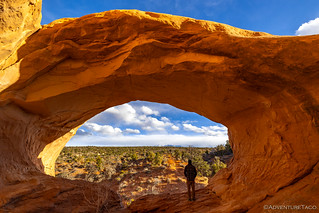
Once I realized that dramatic pinks were unlikely to spill across the sky, I found myself curious about the formation on which I found myself. Sure, I could just head back down to camp the way I'd come, but the more interesting was the terrain behind me - the mesa continuing up a couple of levels, and then a series of small canyons working themselves down into Potato Bottom Basin. With everyone still asleep, I opted for the more interesting route.

After climbing a few hundred feet, I dropped into a side canyon/wash at a slickrock dry fall.
As I wound my way down one side wash after another, I realized that while I was in no trouble of getting lost - this maze would ultimately spit me out into the main was of Potato Bottom Basin - I was definitely in for a longer hike than I'd planned!

Even in these small side canyons, lots of undercut sandstone. And, it's turning into another beautiful day.

Layers and fins. Almost reminiscent of Little Finland in Gold Butte National Monument.
Turns out, I need not have worried. I arrived back in camp just after 8:00am, just the way I'd left it - everyone else still snuggled away in their tents. Ben @m3bassman was the first one up once I started getting my breakfast assembled, and I was surprised to hear how windy he'd felt like the night had been - he'd even gotten up to close up his swingout; worried about the wind catching it and wreaking havoc on his hinges.

As everyone began to stir, talk of the amazing wind storm of the night before initially filled the conversation (clearly, I must have been more tired than I thought to have slept through it), and then shifted to our agenda for the day. Ben had planned on a hike not far from camp - to the ruins at Fort Bottom - as one of the highlights, but Angie's foot, while better, was still not in any shape to make the three mile trek. And so, we decided that Ben, Kirsten and I would head that direction as Will @willhaman21 and Angie took it easy in camp and then made their way to Moab and the urgent care center ahead of us.
It was 9:00am when we parted ways, hoping to meet back up just after lunch to form a plan for the afternoon. As we ascended out of Potato Bottom we began our climb up Hardscrabble Hill - probably my favorite section of trail so far - before pulling off the side of the road at the trailhead to Fort Bottom.

Up we go.

Setting off on foot.
The first half mile of the hike to Fort Bottom is deceptive. Reasonably flat, it makes its way over a peninsula that was formed by a large horseshoe bend in the Green river. Even from the trailhead - with young enough eyes or a pair of binoculars - one can see the highlight of the hike: an Anasazi ruin perched on the top of a butte at the end of the peninsula, a few hundred feet below.
None of us were young enough to see it.

Let's meander out there.

We only noticed (could see) the ruin as we got closer.
Though there were a couple steep sections as we climbed between buttes on the peninsula, the trail was not difficult, and the best section of trail - in my opinion - was a narrow rock bridge that transported us from the base of the peninsula to its head.

Wider than it looks.
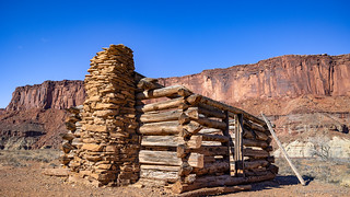
As we made our way out, we spotted the remains of a small cabin far below. Angie had told us of this cabin - rumored to be a stopping point for tuberculosis patients on their way down-river, but more likely the cabin of an early homesteader and rancher who found the fertile soil a perfect place to call home - and I think we all started looking for a side trail to make our way down.

A typical 12' x 14' footprint - the size required by the Homestead Act.
With plenty of eye candy along the way, it felt like we arrived at the Fort Bottom ruins in no time. A final scramble to the top of the mesa, and we were greeted with a tower whose function we'll never definitively know. Perched in this location, and with line-of-sight to Turks Head further downstream, perhaps it was part of a communication chain. Or, with such a well-positioned and defensible overlook of the Green River, perhaps it served a military purpose.

A taller tower, and attached side room.
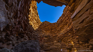
Looking up from the inside.
The tower has survived surprisingly well over the years, though it's clear that some old wooden platforms on the inside have disintegrated, and an old access hole, its top header made of wood, has been filled in with rocks in order to keep the structure standing.
Our primary goal reached, it was a quick discussion to make the decision to find a way down to the cabin closer to the river's edge. The trail ended up being obvious as we got closer, and I found the cabin construction nearly as interesting as the rock ruins above.
Home or hospital?
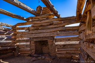
When you've got holes in the wall, good heat is a must.

Hand hewn.
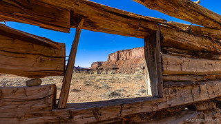
Location, location, location.
Having accomplished our goal for the hike, we made relatively quick work of the trek back to the trucks - a mile and a half with maybe several hundred feet of elevation gain, no big deal. We had maybe a dozen or so miles of the White Rim trail to run - wrapping up the twisty narrows of Hardscrabble Hill, and then making short work of the reasonably well-graded road would lead us to a final set of switchbacks, up and out of Horsethief Bottom, and the end of our two day journey.

A trail of never-ending views.

An arch-in-training.

A lot of work went into BLM-129, and this section would make a good rally route!
At the top of the switchbacks, dirt continued, but it was clearly of a more graded caliber than what we'd become accustomed to. We encountered little traffic as we made our way to UT-313 and back toward Moab, stopping only for lunch at a roadside information kiosk where the wind whipped through our sweatshirts, making lunch a quick proposition!


Arriving in town, we met up with Will and Angie - just wrapping up at the Moab Urgent Care Center - and got the good news that Angie's foot was not broken, and they were 100% up for finishing the rest of the trip with us. Thrilled to have not lost our travelling companions, we all pointed our trucks north and headed out of town and toward a trail I knew well from the only other time I've been to Moab - one we'd travelled at the tail end of the De-Tour - a short section of the Kokopelli Trail, and Dome Plateau.
For me, it was a bit of full-circle - this trip having started across the highway at the Dewey Bridge as I ventured up to Top of the World just a couple days earlier. Today, we'd head west - first out into the plateau, but then to a place I'd never visited: Arches National Park.

Will had aired up on his way into town, so we spent a few minutes getting him back in shape for the most technical trails of the trip.
The entire Dome Plateau area is a spot worth exploring, and while the trails aren't terribly difficult, there are a few places where experience and a good line can mean the difference between a fun day and a bad one. Luckily for us, nothing outrageous happened as we climbed up ledges and through the rock fields that serve as gatekeepers for what lay ahead.

Good clean fun.

Winding our way along the Kokopelli Trail.

The sun finally broke through the clouds that had been increasing throughout the day, and bam! Orange.

Stepping up onto the plateau.

Easy going from here, mostly.
It was right around this time that we had a decision to make. See, Ben had scoped out a new-to-everyone camp spot that he thought would give us a good view down onto some of the arches of Arches National Park. Of course, we also knew of an amazing spot - at the edge of Dome Plateau - that continues to be one of my all-time favorite sites. The problem was, we had about an hour of sun left, and about the same amount of time to drive to either location. We had to make a choice.
I radioed ahead to Ben that we should stop and take a quick look at the map in order to make our decision - perhaps even turning back to another nearby site that I knew of, since I wasn't sure we'd even make it to either of his planned camp sites prior to darkness setting in. I was quickly convinced that pushing forward was the right idea however, when Ben said something along the lines of, "Should we go to the site we know is awesome (Dome Plateau), or should we go to the one we've never been to before (Arches)?"
For me, everything clicked at that moment; maybe it did for Ben and Will too. We were here on an adventure; exploring. We had to go to the site in Arches, because it was the unknown!

Steeper than it looks.

The side steps and trailer hitch of the Tundra did not appreciate this set of ledges.
Having made our decision, I suggested one final stop on the way to camp - at the La Boca Arch. Not within the boundaries of Arches National Park, this little gem was only a quarter mile or so off our route and happened to have the sun dancing across its gentle curve just as we climbed out of our trucks. An indication of things to come, perhaps!

A common perspective, but not the best one.
Ahh, that's better.
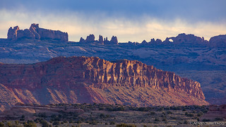
From the La Boca Arch, it was another 10 miles or so to our own little spot along Winter Camp Ridge, just inside Arches National Park. The road here was in surprisingly good shape - a fact that would come in handy as we exited the following day - but that didn't mean we made good time. In fact, this was one of the slowest sections of road for me in particular, as the views to our southeast - of Castle Valley and the La Sals, as well as arches along a ridge in the park - enough to stop my Tacoma several times as I made my way west.

Evening rays.
Dramatic arch.
Eventually I got to camp, the other two trucks already set up and everyone out enjoying the view from what was a beautiful spot. The views - while perhaps not quite so dramatic as Dome Plateau - were spectacular, the sun even highlighting Delicate Arch for us in the distance.

Delicate Arch.
Soon enough, I got my tent deployed as well, and we all set about dinner preparations, hoping to get cleanup done with a little bit of daylight still available.

Camp with a view.
Of course, the sun had a different plan, peaking below the clouds for a couple minutes as it raced towards the horizon, all of us scurrying for our cameras to capture the final rays on the undulating sandstone to our south.

Overlooking the sandstone bowl of Salt Wash.

And then, it was gone.
Dinners were quick as the cold set in. We huddled for a while, none of us wanting to admit that the trip was nearly over, and yet all of us looking forward to the warmth of our beds to shield us from the relentless gusts of wind that seemed to claw its way through every layer of clothing. In the end, we didn't survive long, calling it a night not long after 8:30pm.
It'd been a fantastic trip over the course of three days. Two trails I'd wanted to run for several years done in one shot. Time spent with buddies around the "fire." Even though I'd be headed home at 3:30am the next morning, I went to sleep with a smile on my face, and dreams of the next time I'd make it to the red rocks of Utah.
The Whole Story
 - Canyonlands #1")


Love Canyonlands? Check out
Canyonlands Index
for all the amazing places I've been in and around this special place over the years.
Sir you never fail to amaze me with your photos and written accounts. For the places I haven't visited yet my appetite is growing and for the ones I have visited fond memories return. Kudos to you and your crew.
Thanks so much Ralph! I'm happy to hear that you're enjoying the stories, and hope you do get a chance to return or discover anew, any places that tickle your fancy! ?
I love these trips. Cannot do this as often as we use to, but getting a treat watching and reading your adventures. I AM HOOKED. I cannot get enough. The American so-west is pure heart-stopping joy whever I see any of it. THANK YOU!
I love the too Jeannie! Glad you're enjoying and I hope you continue to into the future. If you aren't already, you can enter your email here to make sure you get notified when there's a new trip posted (and that's the only way your email will be used)
https://adventuretaco.com/subscribe/
WOW that was pretty epic there looking at the la sals and delicate arch.