
Sleeping in our own little private wash was magical. If there was a lick of wind, it went right over our heads and at one of our lower elevations for the trip, it was reasonably warm as well. I think we'd gone to bed exhausted around 9:00pm, and when I woke up at 6:45am for sunrise, I was ready and raring for a new day! The view - a couple dozen short steps up the wash walls behind camp - was a nice motivator as well.


I soaked in the solitude for a while and then whistled down to @mrs.turbodb that it was time to get up. We'd noticed over the course of the trip that the clearest time of day was generally the first several hours after sunrise, and I wanted to make sure that we visited our first stop for the morning - Little Finland (aka Devil's Fire) within that window. We'd even considered camping below the cliffs, but decided against in just in case others had the same idea. This turned out to be a good decision, as the crisp early morning air easily carried a few voices across the desert to my position on the overlook!
A quick breakdown of camp - without the concern that everything was filled with sand this time - and we were on our way.

Like many of the sites we visited this trip, Little Finland is a place with no set trail. A place where one simply wanders, experiencing the magic of the site through their own eyes and in their own way. Should a formation catch one's attention, the route changes on the fly, ultimately resulting in as many routes as people who've visited.


It was no different for @mrs.turbodb and me. We entered the jumble of weathered fins - hence the name - together, but within minutes, if not seconds, we were each on our own path. It was one of the few times I've seen her pull out her phone and start taking photos - an exercise she generally leaves to me on trips. The place was just that unique.


We wandered for over an hour. First here, then there. Separate, then together, then separate again. We'd whistle for each other - to show a swirl in the sandstone here, or a shape in the formation there - then meander apart again. And, arriving just as the sun was peaking over the lowest clouds on the horizon, we had the whole place to ourselves - even the folks camped below weren't out exploring, yet. We really couldn't have asked for anything more.


But eventually we got hungry. We hadn't eaten back in camp because it was so early when we'd left, but now it was getting on 8:00am and our stomachs were letting us know that it was Cheerios time. Employing a circuitous route in order to extend the exploration, we made our way back to the Tacoma to appease our appetite, our view of Bitter Ridge now even more brilliant than it'd been when I'd first woken up.

Having seen what we'd come to see - or at least, what we could see in a couple hours - at Little Finland, we'd nearly completed our loop of Gold Butte. All that was left was to continue along Mud Wash Rd, back towards Whitney Pockets, where we'd head east - on dirt - towards the Grand Canyon. As usual, I make that sound more straight forward than it actually was - since sights along the way were sure to delay what could probably have been a simple 4 hour drive.

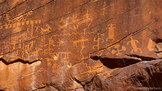
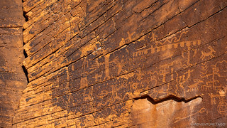
The first of those stops was less than 2 miles away at the Mud Wash petroglyph site.

Composed of a few panels, high above the wash - perhaps even authored when the bottom of the wash was several feet higher than it is today - these glyphs were reasonably bright given their location on a main thoroughfare. I wonder how many folks go blasting by on their UTVs, completely unaware of what they are missing.
Finally, we set off towards Whitney Pockets. How far would we make it? Probably only far enough for another photo.

Now, the plan at Whitney Pockets had been - as with the previous day - to just drive on through, since we'd explored the CCC cistern and a few other sites only a year ago on our first trip to the Eastern Mojave. But, as we slowly drove through the area, we realized that the throngs of people who'd been there for the long weekend had already left, rendering it nearly deserted.
How could we resist a quick look at the dam? I know I couldn't.

Somehow, we kept our visit to five minutes, and soon we were headed out of Gold Butte National Monument on Whitney Pass Road - a byway that would shuttle us east into Arizona and the Grand Canyon-Parashant National Monument.


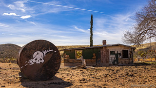
As we tooled along - the road in pretty great condition since there hadn't been any rain recently - we were making good time until the glint of windows on the ridge above us caught my eye. A cabin, with a 2-track road leading off the main route - how could we not go see what that was all about? Having also gotten cell service as we hit the ridge, @mrs.turbodb was also fine with this little detour, though I couldn't resist ribbing her that she was missing life buried in her cell phone.

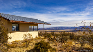
Descending the pass, we were treated to another display of red-and-orange rock outcroppings - but the thing that caught our eye was another cabin. From a distance, this one looked like it might be occupied, but on closer inspection it was far from habitable. Obviously an old ranch, the structure itself had been vandalized over the years, and only the water trough seemed to be in use, judging from the tens of thousands of cow patties in the area.
It was getting on noon by this time, and our stomachs once again were firing their alarm bells to let us know that it was time for potato chips. We decided that the right place to stop was probably the same stretch of road where we'd turned around last time - the mud too deep, and my tires too slick, to continue.

I should note that as we stopped, we noticed that the wind was starting to pick up again - as it had every afternoon - and once again it was blowing in the exact opposite direction of our travel. Seriously - it was as though for the entire trip, if anyone needed to know which direction the wind was blowing, you could assume our truck was a windsock, pointed into the wind.
But now I'm just ranting, when I should really be thankful for the tuna sandwiches, which were once again, delicious.
Lunch complete, we soon completed our jaunt on Whitney Pass Road (which I suppose became Mojave County Road 101 in Arizona) and joined up with Mt. Trumbull Loop road - which would shoot us south to Whitmore Overlook and the very edge of the Grand Canyon.
As you can imagine, as we turned south, the wind shifted as well. Just saying.


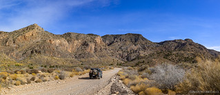
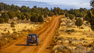
Still quite early in the afternoon, we were in no real rush to reach the end of the road, as we figured that - what with it being the middle of the week - we'd be the only ones there. And so, as we travelled along, I stopped at several of the more interesting places along the way to show @mrs.turbodb some of the awesome things I'd seen for the first time on the F.U.Rain trip back in 2018.


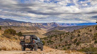
The trip along Mt. Trumbull road initially climbs as you head south - up to 5,500' or so - before dropping down again towards the Colorado River. And let me tell you, the dropping down part is spectacular. I'd forgotten how great this approach was, and I was quite regularly out of the truck in order to take photos of the landscape as we shed elevation.

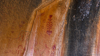
It was @mrs.turbodb who spotted a rock - high above the road, at the base of and adjacent plateau - that she thought contained some petroglyphs. Using her binoculars, I was pretty sure it didn't, but we had plenty of time before sunset and what better way to spend it than parking the Tacoma on the side of the road in the middle of nowhere and hiking to a random jumble of patinaed rocks in search of ancient art?
That might sound sarcastic, but I'm serious.

I don't want to say I was right, but let's just say that as we got closer, it was clear that there were no petroglyphs on the rock that we'd set out to investigate. However, along the way we had come across a BLM marker urging us to protect our heritage, so we knew there must be something worth finding in the area. So, with nothing to go on but the orientation of the marker, we set off - this really was turning into quite the treasure hunt!
It took nearly a mile of hiking and glassing with the binoculars before we hit the jackpot. It wasn't rock art that I ultimately spotted, but another marker. And, once we arrived at the marker, there was only one place nearby that looked out of the ordinary.

There, under the shelter of the wave, were pictographs. These were special - bright and polychromatic, they contained geometric shapes, animals, plants, and even humanoids. How lucky were we? I mean, except for the headwinds, obviously.


As we marveled at this extra-special discovery - all the more satisfying since we essentially set off on a whim - the sound of an engine rumbling down the road reached our ears. Uh oh. There was obviously nothing we could do about it - and I knew there were a couple of sites at Whitmore Overlook should someone get there before us - but we headed back to the Tacoma regardless, as we didn't want to end up coming all this way for nothing.
It probably took us twenty minutes to retrace our steps - our pace much faster now that we were no longer in "hunt mode" - and just as the truck came into view, so did a full-size Dodge Ram sporting a pop-up camper. And there was no way we were going to be on the road ahead of them.
Well, crap.
We hustled down to the road as the truck rumbled by, and quickly climbed into the Tacoma as I pressed the skinny actuator in the foot well just a little harder in order to catch up. We did, reasonably quickly, and to my surprise the Dodge pulled to the side to let us by!  For the next mile or so I continued to work the skinny pedal liberally, drifting through a couple corners in order to put a little distance between our vehicles.
And the view kept getting better.


And then - surprising both of us - oncoming traffic. A rental Jeep carrying two young whipper-snappers came gingerly up the road towards us. Could it be? Were we really lucky enough that the engine we'd heard earlier belonged to this Jeep? All we could do was hope.
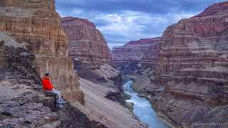
Then, we arrived. And we were alone.


Eventually - nearly half an hour later, as we were setting up camp - the pop-up camper arrived; but after a few photos, they retreated to a nearby spot a little further from the cliff's edge - neither of us able to see the other in this grand place.

We didn't wander far from the edge for the rest of the evening, so dramatic was the experience. We ate an early dinner so as to take advantage of the warm temps (at only 2,500') and make clean-up a breeze. And then, we enjoyed the sunset.
Watchin' the tide roll away.


It was by far our favorite site of the trip, and one that I was excited to finally share with @mrs.turbodb. And still, as perfect as it all was, and as sure as we were as to our plans the following day - things always have a way of working themselves out differently, and tomorrow would be no exception!


 - Mid-Winter #4")


Awesome as usual....! Thanks for sharing! Pictographs with a fish-bone motif... Wow!
--Paul
Brilliant photography and write up, as usual. Awesome surprise pictograph find under such an unusual rock shape. One can only imagine the different people over centuries, even millennia, having conversations under that rock and leaving their mark on it. The pink and purple of your final shot are incredible.
Thanks Mark! The pictograph was splendid to come upon, a highlight of the day for sure.