 Bradshaw Trail #4")
Right smack in the middle of my Bradshaw Trail adventure, I was presented with an option - travel the trail as outlined in my guidebook - Gold Road to La Paz, an Interpretive Guide to the Bradshaw Trail - or take a 75 mile detour north over Graham Pass to a nearby desert attraction - Corn Spring.
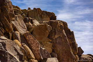
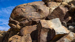
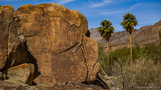
Normally, I'd probably have opted to just keep going, but this time the decision was a tough one. While not on the actual route, my book had included a photo of some petroglyphs at Corn Spring, and if I'm a sucker for anything, it's rock art.
Early on in my trip - and even as I started the Augustine Pass loop from Chuckwalla Bench, I'd hoped to make it to a BLM campground at Corn Spring to spend the night. That all flew by the wayside as the loop took me longer than anticipated, and it was 9:15am the next day when I finally reached the intersection of the Bradshaw Trail and Graham Pass Road.

Unlike the Bradshaw Trail - which at this point in the route was a rather high-speed raceway - the road leading between the Chuckwalla Mountains to the south and the Little Chuckwalla Mountains to the north was anything but high speed. Still, I made the 5-mile journey in a little more than 15 minutes, so it's not like I was crawling along, either.

Descending the pass, and then all the way across the valley floor, things got a lot better. The road was wide and smooth, and it was only my aired down tires that kept my speeds limited to 50mph. I made good time on the next 35 miles of trail, stopping only a few times for some quick photos before arriving at Corn Spring.

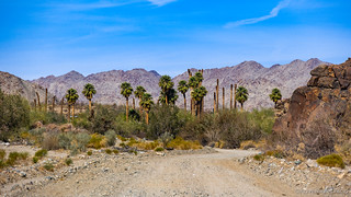
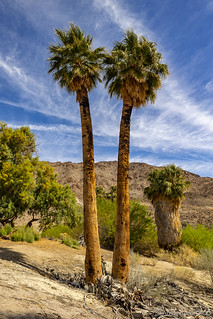
I nearly arrived at Corn Spring just before 10:30am, the sight of the palm trees quite stunning against the backdrop of ragged ridges. Even so, I must admit that it wasn't what I'd been expecting, with a full 50% of the palms missing their fronds.
Having done a bit of research prior to setting off on the trip, there were several aspects of this place that I was looking forward to exploring. There were - of course - the petroglyphs, but there was also an old cabin and mine, as well as what looked like a cluster of houses several miles deeper in the mountains. Finally, some 10 miles from the spring, what appeared to be the remnants of a mining operation. Really, as I look back on it now, there's no way I was going to pass this up!
The petroglyphs being at the top of my list, I set out immediately to find as many panels as I could. There are quite a few, and I recommend spending a bit of time broadening your perspective if you should visit this area yourself; not all the etchings are in one area!


My exploration of the petroglyphs complete, I headed the final little way to Corn Spring campground. Located just above the spring, it was a desolate place on this hot spring day, only a single campsite - of ten - showing any sign of life. Even then, I'm sure the resident would have quickly vacated the area, had just about anyone show up.

Corn Spring itself was no longer the gurgling oasis that I imagine it once was - no water was present above ground, and everything around seemed quite dry. To further add to the arid feel, it appeared that a fire had ravaged the palms, leaving many of them topless.

What with it being only 11:00am at this point, I resisted the grumbling of my belly for lunch and pushed on into the mountains. I figured that I could either find a place further up the road to break out the taco fixings, or at the very least, I could stop by Corn Spring on my way out and set up the kitchen in the shade of one of the largest salt cedars I've ever seen. For now though, adventure called.
Just a mile or two up the road, I made my first stop.

This was Gus Lederer's cabin. Perched above the wash on a claim he called "The Little Chad," Gus Lederer moved to this site in 1915 where he built a small two-room cabin for himself and another for passers-by. Using Corn Springs as a headquarters, he'd venture out on prospecting trips - never striking it rich, but making enough to get by.

Besides prospecting, Lederer was also an artist, philosopher and animal lover. He had a cadre of nearly 20 burros, for whom he would make flapjacks every morning. Eventually, people began referring to him as the “mayor” of Corn Springs, always friendly and helpful to anyone who happened by. He died in December 1932, when he was unable to receive treatment quickly enough after being bitten by a black widow spider.


From Lederer's cabin, I continued along the same road, curious as to what I would find. I'd seen some structures from my pre-trip planning, and wondered if there were perhaps some residents that still lived in this area, far from civilization but happy for the solitude. In other words, desert lovers like Gus.
The first building I came to looked to be in pretty good shape, but it was also quite clear that there was no one around - at least at the moment. It turns out that this was the Gold King Mine, and was mostly abandoned. I say mostly, because the lower level porch was packed with stuff as though someone had been living there. It was a bit creepy, really, and I decided that hanging around was probably not the best of ideas.


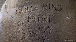

It was when I saw the spray paint on a back wall that read, "At the Gold King we mine our own business - so should you," that I made a beeline for the door and continued on my way. As the road forked, I realized that the "town" I'd seen was on a short spur off the main road, and initially I headed that direction. However, as I neared the buildings, I couldn't tell if they were occupied, and not wanting to bother any of the residents if they were, I decided to back off and take a few photos from a distance.
One thing is for sure - the residents of a place like this would need to be hearty souls, and they'd definitely put in a lot of work to their desert home.

With that, I carried on towards the end of the road. Unsure if I'd even find anything of note there, I enjoyed the trail as it wound in and out of a a wash, slowing gaining elevation in the middle of the Chuckwalla Mountains. The landscape here reminded me of Alabama Hills - weathered granite outcroppings reaching up towards the sky.


I reached the end of the road right around noon, the sun high in the sky and my air conditioning blasting away in the cab trying to keep me cool. It was generally successful as long as I didn't turn the engine off, so as I got out to take a few photos, the Tacoma continued to sip on - what was now - just a little fuel that remained in the tank.
There wasn't a lot at this old mine, but what there was told a story. A couple of adits and some old metal sleds over which buckets of ore were dragged before being dumped over the side of the hill and collected in chutes below.


"A cracked granite rock you say? Sounds like the perfect place to grow." -Barry the Barrel Cactus.
My exploration complete, there was no doubt now that it was time for lunch. I considered - for a full three seconds - having lunch here at the end of the trail, but with no shade to be seen and temperatures easily over 100°F, I quickly pushed that thought to the back of my mind and bee-lined it for the shade of Corn Spring.


Originally, I'd planned for Corn Spring to be my only side trip as I ventured away from the Bradshaw Trail. However, as I'd climbed into the tent the evening before, I'd made the mistake of checking my phone for service. I was sure I wouldn't have any, given my location deep in the Chuckwalla Mountains, so you can imagine my surprise when I had one full bar - and sometimes two - of LTE signal.
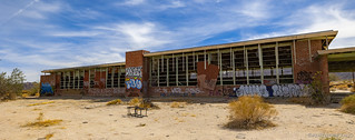
As if to prove that it wasn't real signal, I fired up a bookmarked I'd created to Mike's @mk5 trip reports for the Bradshaw Trail, just to see if there was anything I was forgetting. While I seemed to be doing just fine on the trail itself, I took note of a recent visit to Desert Center - a town along I-10 that has fallen on hard times and is slowly turning into a ghost town. Only another eight miles up the road, I decided that I really ought to check it out.
As I often say, "I'm closer now than I will be when I'm home!"
Not really knowing much about this crazy town - I hadn't done any reading about it at all before showing up at the freeway offramp - I didn't really know why it was abandoned or when people had decided to leave. What I can say after visiting, is that it has a strange feeling to it - people seem to have simply walked out of their homes, not taking anything with them. The school building has been destroyed, but all the furniture is still inside. It's almost as if people were forced to flee, some invisible catastrophe necessitating the evacuation.
But, as far as I know, that was not the case at all.


Still in a state of misunderstanding - I don't really know how to better describe it - I made my way back to the Tacoma and along the high-speed route to Graham Pass. I squirreled away in the back of my mind a desire to find out more about this strange place, but for now, I just wanted to get back to a happier place - the middle of nowhere; the desert!

As usual, my goal - to get back by 1:00pm in order to continue the Bradshaw Trail - was really more of a wish, as it was just after 3:30pm when I turned the Tacoma east again towards the last section of the Chuckwalla Bench and the Mule Mountains. Like any adventure, this one had been totally worth it. Leaving me with more questions than answers, I reveled in the unknown - knowing only that there was more of the same to come!

Hope you enjoyed this adventure. There are, of course, many more to come!


Interesting! Way back in the 1960's when my friends and I did a lot of desert and mine exploring there were some amazing things to find, more than now. On one trip near Yermo we found (out in the middle of nowhere up a dirt road), full wooden kegs of nails, some old pallets of military axle grease (dated 1940's) covered with tarps shredded by the wind, an various rusted out metal tools. Took some of the cans of grease which lasted us many years (yes, it was still sealed and good). Not likely to find anything like that anymore. A few days ago my mint copy of the guidebook arrived (Gold Road to La Paz) and it's quite a good read with good maps, locations, etc.
Hello: I have read all installments of this adventure and found your work to be very entertaining, as always. I am curious about two things -- Why didn't you take this trip in the Winter, rather than the Spring? (While the nights would be cooler, the daytime high temperatures would be much more comfortable.) And, how do you dare to travel alone? Even though my Jeep is fully stocked with recovery and repair equipment, I cannot conceive of traveling these desolate desert trails without at least one other vehicle. (I guess you are just braver than I am.) Great stories. I enjoy them very much. Thank you for creating them. Oh, and one other thing: What camera do you use? I am a long-time, die-hard Nikon fan and I still have all of my old film cameras and lenses, but I now shoot in the digital domain.
Hi Bil, I'm happy to hear you enjoyed the stories (and that it sounds like you've read others as well); it always puts a smile on my face when I hear that someone got a little something out of one of my adventures. I also really appreciate it when folks ask questions - since I feel like the most valuable form of communication is conversation rather than a single voice, so thank you for these and feel free to reach out any time! OK, so on to your questions...
Stay safe out there and of course, have fun! 73s
Hello, Again:
I was not going to reply to your answer but there is something I need to clarify. So, I will do that and then make a few other comments.
I did not say, nor do I feel, that you are crazy. Maybe that word does not hold as much gravitas for you, but it makes a powerful statement for me -- One that does not reflect my position regarding your travel choices.
That said, I understand and appreciate the freedom inherent in solo travel.
I did minimal research on the travel guide you recommended. Until then, I did not realize that it is actually an historical document and has long been out of print. It must be very coveted because one vendor is asking $505.00 for a single copy. Perhaps it is, or will be, available as a reprint, at a lower cost, in the future.
I followed the hyperlinks you supplied and found them to be equally enjoyable. My heart broke for you when I learned that you smashed your camera and favorite lens. I could somewhat sympathize because, many years ago, my car was broken into, in New York City, (ironically, while I was touring the Statue of Liberty), and all of my camera equipment (except the single body and lens I was carrying) was stolen. The saddest part of this episode was that the thieves also took about 50-cassettes of exposed 35mm Ektachrome 160, which represented all the photos I had taken, thus far, during a three-month tour of North America I was doing. That tragedy taught me to use pre-paid mailers and ship each roll of film to the processor, as I finished it.
Finally, I know that Canon vs. Nikon is a lot like Ford vs. Chevy -- a lot of emotion is involved. Even though I have been a dyed-in-the-wool Nikon owner for 50-years, I am pleased that you are so happy with your Canons. That said, I cannot imagine using any DSLR (or mirrorless, with which I have no experience) camera equipped with an electronic viewfinder. You have adopted that technology, and given reasons why you find it superior, so I respect your choice. But, I cannot foresee ever going that route.
As always, it is a pleasure to read your reports and I want you to know how much I enjoy them.
<>
Hi Bil,
Apologies if I used the word "crazy" in a way that you didn't mean it. I suppose that to me - at least in the context of using it about myself - I meant it only as "different," and your clarification is a good reminder that the words we use can have different impact on different people!
I do enjoy the freedom, and I also enjoy the self-sufficiency that solo travel provides. Or maybe the self-sufficiency is really a combination of the adrenaline derived from being in situations where I'm problem-solving and the excitement of discovering things I've never seen/encounter before.
As for the other bits I linked for you, and you enjoyed - I am thrilled to hear it! Certainly, your camera story is much more tragic than mine - what a bummer that must have been! For me, though I was bummed at the time, it has turned out to be roughly a non-issue, since the new camera is even better and the incident forced me to splurge on some new glass; a good thing in the long run. ?
For the viewfinder - I had to go back and read what I wrote. Like you, I am not a fan of the electronic viewfinder; I think it is my least favorite thing about the mirrorless cameras. There are a couple reasons for that:
All that said - and while I'd go back to a glass viewfinder in a heartbeat if I could - I think electronic viewfinders are the way of the future. Hopefully they - and battery tech - will get better and better over time, as will the gripes I have about them. One thing I've found is that the EV is a nice way to review photos when it's bright outside, since, with your eye up to the viewfinder, you get a nice, bright playback, rather than trying to find a good angle to view the screen under sunlight.
Thanks again for finding your way here and sharing your thoughts and enjoyment, I really do appreciate it!
By the way Bil - I forgot to mention that the book is one that should be picked up second hand, or from some place other than amazon (though I linked it there, as I suspect that it is the most likely link to persist into the future). A good (alternate) place to purchase it is here: https://mdhca.org/cart/gold-road-to-la-paz
HI ~
Real quickly: I just wanted to let you know that I used the hyperlink you supplied to buy a copy of the "Gold Road" book. When I got to the MDHCA Website, I realized that it was the same place where I bought all four volumes of the East Mojave Heritage Trail Guidebook. Thanks for the tip!
<>
Another great read, Dan. These last two in the series were interesting, as I had never done these branches from the Bradshaw in my travels, and usually found the last section of the trail rather uninteresting. Part of the reason is we usually needed to hurry to finish the trail in a weekend.
As for Desert Center, I have been there, and can add a bit of history. The "town" was founded by Desert Steve Ragsdale in the 1930's, I think. He opened a gas station and garage for travelers across the desert between Blythe and Palm Springs. He was quite the character. There are several articles about him early in The Desert Magazine, as you will see. After he died, his children apparently had little interest in keeping up the family businesses, and the town declined.
Thanks Tim! I look forward to reading about Steve and shedding a bit of light on the strangeness that is Desert Center today. My understanding is that Kaiser (of the health insurance business) also got his start there, as one of the first places where a small amount of a worker's pay was deducted from their salary and used to cover future medical costs, which is an interesting tidbit!
You are partially correct about Kaiser. I don't know all the details. The Eagle Mountain Iron Mine was owned by Kaiser Steel. The railroad you crossed several time on the Bradshaw carried the ore from the mine, located NW of Desert Center, down to a main line at the Salton Sea and on to the Kaiser Steel plant in Fontana. I believe this was in the 30's and 40's. The plant is still there and operational, but much smaller. (Some of the land was sold off to build the California Speedway racetrack)
Around the same time, the Colorado River Aqueduct was under construction to carry water from the Colorado River to Los Angeles. The path of the Aqueduct passes close to the mine, and much of it is in long and deep underground tunnels through the mountains. Old topo maps show the path of the aquaduct, both above and below ground.
It was the workers on the CRA who had a small part of their pay deducted for medical costs. There was a headquarters camp for the CRA in Berdoo Canyon, on the SW side of Josua Tree NP. Near this camp was a vertical shaft for tunnel workers along the midpoint of the tunnel through the San Bernardino Mountains. The camp had a small but well equipped hospital which is what the workers pay deduction paid for.
At some point, the doctor that ran that camp hospital got together with Kaiser to form what would become Kaiser Permanente.
Some of this I got from magazine articles, and some from a doctor friend who used to work for Kaiser.
The camp is still accessible, with only building foundations remaining. You can drive a bit forther up the hill to where the shaft was, but the area has been smoothed over.
It is fascinating to me how so many seemingly unrelated things are, in fact, interrelated.
Looks like I got some details wrong, but the gist of the story is correct. Look up Kaiser Permanente in Wikipedia for the full history .
In 1973 when I started at Eagle Mtn. the workers ins was covered by Fireman’s fund not kaiser which seemed odd to me, I quit 1980 July
I worked on the drills, shovels, D9, loaders .
Thanks Richard - that is odd, I agree. Also, I have to admit a fascination with how people like yourself - who have a relation to a place that I visit - stumble upon my stories. I know this wasn't specifically about Eagle Mountain, but I hope you enjoyed a bit of a time warp back to your experiences in the area! ?
What's with the saguaro in the photo with the place with the firewood stacked up outside? Had to have been a transplant... but why? I guess somebody moved from the Sonoran Desert and wanted some reminder of home, because it sure didn't grow there naturally.
I'm sure you're right Dick - there were a few of those around some of the properties there, so I suspect that perhaps several folks from the same family lived in the area, or perhaps just good friends with similar tastes.
Also, I was under the impression that this was part of the Sonoran Desert (that the Colorado Desert is a sub-region of the Sonoran). Would you say that once you head north of the Chuckwalla Mountains, you're no longer in the Sonoran/Colorado? Not that the saguaro is native to this area, I'm just trying to get my bearings! ?
The southern half of Joshua Tree NP is considered to still be in the Colorado Desert, which I think is just north of the Chuckwallas, isn't it? Lower elevation and warmer temperatures than the Mojave in the northern part of the park. I know in name it's the Sonoran, but it doesn't much look like it to me, lacking saguaros. I suspect the reason they don't grow there is because the summer is dry, as opposed to the Sonoran in southern Arizona/northern Mexico, which gets practically half of its yearly rainfall from the summer monsoon.
Fascinating! I had no idea that the Sonoran in southern Arizona/northern Mexico got/gets so much of its rainfall from the summer monsoon. What I'm realizing is that I've really not spent enough time in the Sonoran - something I'll need to change in the coming years!
I bought five acres a few miles south of the Bradshaw Trail in 1992, just off the road that used to go through Salvation Pass in the Gunnery Range. Have been adventuring out there since, even though I live more than 2,000 miles away now. Thank you so much for these articles and pics!
Wow, that's awesome! I'm surprised you were able to get land on the south side, since I thought that was all gunnery range down there. I'd love to hear more about it, and your experience adventuring in the area!
(and sorry for the slow reply, I just found a bunch of comments that were incorrectly marked as spam, so I'll need to dig into the guts of the site to figure out what's going on)
Hello from Colorado, expecting more snow tonight and tomorrow. I yearn for the desert.
The Bradshaw Trail has been on my list, not a bucket list, for some time. I have thoroughly enjoyed your four articles on the subject, and I have saved a lot more of your adventures. I love Mrs.Turbodb and now you've added a Mini.Turbodb.
I have the Gold Road to Paz, but I didn't get it from Amazon. It is so new I'm afraid to open it.
I have used Nikon cameras since the 70s, first film, now digital plus a point and shoot. You're supposed to be able to use older lenses on the newer digitals, but it doesn't always work out real well. It has been my intent to travel alone since 2013. I have two great traveling companions, but they have restricted my movements. Now I go where I want, stay however long I want, and do whatever I want (with caution). I have a great support group at home, I leave itineraries with family, and call my husband every day I have cell service. Now my daughter gets those calls. My husband wouldn't let me go out again until I got a PLB in 2017. I've never used it, but it's additional insurance for safety.
It's a great adventure to car camp, like your tent, but I do it in a Jeep Grand Cherokee. I also have had my share of mishaps, but have been able to handle them. The desert isn't as lonely as one would think, but I love the solitude and quiet. I have a small bin with car supplies, another with camping supplies, and I pack milk crates with food and water. Oh, and don't forget a cooler or two. You're likely to find me in the desert in July. On purpose.
Please don't stop writing about your adventures.
Darlene - what a story, thanks so much for sharing it! I can imagine that winter is hitting hard right now in Colorado; comes with the territory I suppose, given the elevation and terrain. Still, a great place to be in the summer and fall - some of my favorite trips have been to Colorado.
Like you, the desert calls to me in the winter. We don't have as much snow up here in the PNW, but it's always wet and raining; such a good time to head south to the vast openness in which roaming for days without seeing another soul is still possible. As you mention, a quiet place, but not lonely.
I hope you have a chance to get to the Bradshaw. The book is a good guide, but be aware that a couple of the side trips are now in wilderness areas and shouldn't be driven. Still, there's so much history to explore along the way - and the military range to the south provides constant entertainment (if you're into that kind of thing) if you go during the work week - that it's well-worth spending a few days in your Jeep, enjoying it all. (And definitely head over to Corn Spring (at the very least), it is fantastic!
Enjoy yourself out there, and any time you have something to add to one of my stories, or if one of them reminds you of one of your own, I'd love to hear how you've experienced the desert or an adventure!
?
Great to get your reply. At least we have desert in Colorado. The state is considered high-altitude semi arid desert. But when it rains or snows, it pours, and it gets bad. We're expecting a foot of snow where I live about 25 miles east of the front range. I've lived in Colorado all my life, and my mantra is I'll believe it when I see it. With all the weather upheaval in California, we could get anything.
I'm going to have to leave comments at your other articles, instead of including everything here. So much to share.
Looking forward to the comments Darlene! I usually think of high mountain peaks when I think of CO, but I suppose that's only part of the story - in the same way that I think of my home state of WA as being a wet rainforest of tree tunnels, but in reality, the eastern 2/3rds of the state is desert!
Great read. I am spending some days in the Chuckwalla's and Wiley's Well District. I cannot find much info on graham pass road from the I-10 to the Bradshaw Trail as far as difficulty. Hoping to start my journey on the north side of the Chuckwallas and then cross over to Bradshaw.
I too like to travel solo, but not without doing a bit of homework. I have a Tacoma TRD Off Road, stock 4x4. Is graham pass difficult; are there technical areas that pose much risk for a solo, moderately equiped and experienced desert traveler?
Hey Marcos, I think you'll be fine. There might be a couple places where you have to go slow, but there's nothing super-technical about the route!
I was just through Desert Center yesterday on my way home from my first ever trip to Joshua Tree. Running out of the desert, just before the big storm hit!