

As you may recall from the previous story, we left off in Gold Point - so far, our favorite sort-of-ghost-town of the trip, and I promised two naked ladies and a penguin in the desert.
I should warn you now - I probably oversold it. But anyway, let's get started. A little before 11:00am, we pulled out of Gold Point, excited for the next segment of our adventure, and happy to be back in the truck and out of the already 94°F heat that was getting oppressive in the desert. In the distance, Death Valley's Inyo Mountains rising tall, and still with a bit of snow.


A sign, as we exited town, reminded me of our next pit stop, the Hardluck Mine Castle, some 10.5 miles away.

We had - perhaps predictably - another set of hills to climb and descend before reaching the Hardluck Mine, but as we crested the ridge that served as our saddle through the Gold Mountains and the landscape opened up before us, any monotony we'd felt about the desert terrain was quickly quelled, the mountains, valleys, and playas on full display for us from this vantage point.


Now about halfway to the castle, we proceeded down the mountain until we could see it perched above us - nestled on a finger on a neighboring ridge. The Hardluck Mine Castle, like the Stokes Castle we'd seen before, was stretching it - in my opinion - with the term "Castle."

No matter. In a few minutes we reached the spur road that served as the mine's entrance and driveway, several signs present along the road. One of course was the name of the mine, clearly now a tourist destination.

The other was a less welcoming sign alerting visitors to only proceed up to the mine if it was between 11:00am and 2:00pm, and they were committed to a $10/head paid tour. We weren't, but that didn't mean we weren't going to snap a photo of our first naked lady in the desert before continuing south.

Now, one of the things I find most fun about desert travel is that every now and then, something completely unexpected crops up - or, perhaps more correctly - is stumbled upon. That's exactly what happened to us as we were descending down a long alluvial plain into the valley and something unnatural caught our eye along the side of the road.
It was a shrine. To a pickup truck bed trailer.

Lovingly - and perhaps a little jokingly - created by its owner, the shrine was complete with a compass, sundial, solar lighting, and a fish called Wanda. Definitely legit when there's a fish in the desert.


Still chuckling and chatting about the various knick-knacks strewn about the trailer as we headed further down the trail, it wasn't 15 minutes later that we came to another unexpected discovery along the route - or at least reasonably close to it: an old mine site, its smelter still in amazingly good shape.


Built of a combination of wood, metal, and stone, it was clearly newer than some of the other ruins we've come across in our travels, but we've only ever visited the site of one other smelter - in Valley Wells, in the Mojave National Preserve - and none of the actual building was still present there.
Here, not only was much of the structure still standing, but piles of ingots were strewn about, the crucibles used to form them, cast to the side.


To top it all off, a few of the old mine buildings - likely administrative buildings, housing, and perhaps a dining hall - were still standing, though had seen better days. Even in what was now 100°F heat, we spent a good 20 minutes poking around!

Eventually though, all good explorations must make way for the next, and the road beckoned us onward toward the unknown. Well, unknown in that it extended - completely straight - for 30 miles into the distance, and we could see nothing but desert.

This road, though it was straight, was also in terrible shape. Rocky, rutted, and full of holes, we made slow progress as the landscape passed unchanging for more than 90 minutes. It was long enough and boring enough that @mrs.turbodb snuck in a nap, and I considered doing the same.
But then, actual intrigue - a fence! As we pulled up, a smile spread across my face as I made out the writing on the sign. Was it true? Could it be? Were we really entering one of my favorite National Parks?

I'm sure that not many people visit Death Valley's Nevada territory, so it's fun to say that we have - and the views were nothing to scoff at either! We had - because @mrs.turbodb is a better planner than I - brought along our copy of Hiking Death Valley, but alas, there was nothing noted in this little corner.


We'd left the truck on - the A/C keeping the interior cool(-ish) given the complete lack of any shade at this time of day, and after re-stowing our gear in the bed, we were on our way. Roads were sparse here, but there were a few that wound their way off the main drag, onto various hillsides - something to investigate once we returned home, possibly for a future exploration of the remote corners of the park!

For now though, we stayed the course, making our way into Rhyolite - yet another mostly-uninhabited ghost town just west of Beatty, NV and just east of Death Valley. Between 1905 and 1907, Rhyolite once had 8,000 - 12,000 residents and three regional rail lines, until a financial panic in 1907 triggered the town's downfall. By 1910, only 675 residents remained.
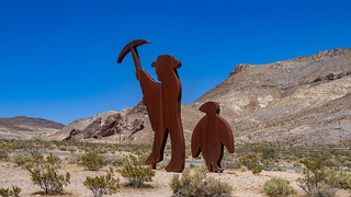
Just outside of Rhyolite is the Goldwell Open Air Museum, where several works of art have been installed on the grounds. We'd stopped here on our first trip to Death Valley back in 2018, but we figured it was worth another look. After all, there was a second naked lady and a penguin in the desert!


From the museum, we continued a few hundred feet up the hillside into Rhyolite proper. So close to the park, the ruins here have been very well preserved despite the throngs of tourists that it sees every year. Unfortunately for us - or perhaps fortunately depending on how you look at it - the town seemed to be closed this year, and one of the attractions we were looking forward to - the bottle house - was locked away.


Most interesting - to us - in our tour of Rhyolite, was the route we took out of town. We've previously always treated the road as an out-and-back, but it turns out that if one continues through town and past the old train station, that dirt roads lead nearly all the way to Beatty. Perfect!


Fueled up - the Arco in Beatty now accepting credit cards, making the process so much easier - we headed east into the Bare Mountain area. Not expecting to see much so close to town, the colors in the rock of the mountains were a nice surprise - a bit reminiscent of Artist's Pallet in Death Valley. Plus, off of the route a way, a mining cabin tucked into dozens of tailings piles was enough to lure us over for a look.


With that little detour, it was nearly 4:00pm when we climbed up to the top of Bare Mountain for a 360° view of our surroundings - under the watchful eye of a large radio tower of some sort perched at the top.

Update 2020-08-19
That's an old AT&T microwave long lines site. Those distinctive antennas on the top are called Hogg horns and are unique to that network. The equipment building is made of reinforced concrete to survive moderate blast from relatively distant nuclear blasts as this was considered a critical network in the cold war. This site is a simple repeater connecting other sites on the opposite horizons. The site to the north is on Gold Mountain right near Gold Point. The site to the south is right by Mercury on the edge of the NTS.
These sites were how most long distance phone calls were connected from the 1960s through the 1980s. Television broadcasts were also sent nationwide through this network until satellites became a more cost effective method to link local stations. In the US this microwave network remained competitive with coax cable based networks until the dawn of fiber optics. The economics of fiber optics are simply astounding compared to coax cable or microwave and so AT&T divested themselves of this network in the 1990s. Most of the sites were sold to tower holding companies who lease them to other users now. Many of the sites still have the original now unused Hogg Horns sitting on top of them like this one. You can see on this site there are two new smaller conventional drum shaped antennas pointed in the same directions the pairs of Hogg Horns are pointed.Ken @DVExile


Down the east side of Bare Mountain, we were headed towards Yucca Flat. We'd never make it into the flat proper of course - that area being off limits as part of the Nevada Test Site where 739 nuclear tests, and 827 detonations took place between 1951 and 1992. It's now known as "the the most irradiated, nuclear-blasted spot on the face of the earth," (Nuclear America: Military and Civilian Nuclear Power in the United States 1940–1980)
But that wasn't what caught our attention at the time. No, for us, the highlight of our short time near this famous place was running into wildlife we'd see nowhere else on this trip - the first roadrunner we'd ever seen (!), and a bunch of burros!


Old mines in the area meant that the roads here were wide - and speed limit signs reading 45mph meant that they'd apparently been well groomed at one point in time - but that time was long past and the little rain and plentiful wind had definitely taken a toll on the roads. For 10 miles or so we made slow time, until - in the distance - a huge sand dune was visible on the horizon.

Our route took us immediately next to the dune along its western edge, and we considered for about 2 minutes stopping here to camp so that we could hike the dune as we've done in Eureka Valley, Hidden Dunes, and Kelso Dunes on previous trips.
But here in the Amargosa Valley, the temps were the hottest we'd seen, and even a little after 5:00pm, they it was still stifling whenever we'd get out of the truck, so we decided it'd be better to leave that hike for another day and we'd try to find somewhere a bit cooler to call home for the night.


From Big dune, the route took us south and east, crossing over the could see that to our south, we'd be passing through OR-373 and towards a spot on the map that looked green - Ash Meadows National Wildlife Refuge.
I don't know about you, but green on a map always makes me think "cool mountains and forest," though I knew - even at the time - that it was really just a way of differentiating the wildlife refuge boundary from the surrounding BLM land. Regardless, we headed that direction, hoping that gaining even a little elevation in the low mountains we'd be passing through would give us some relief from the sun.


We only touched the top corner of the refuge - the area definitely greener than its surroundings - before popping back into BLM land and onto the dry playa that is Amargosa Flat.

I don't know if the playa is dry year round, but two things are certain here: First, much of the playa is part of an active clay mining operation - the white clay a relatively rare commodity, apparently. As such, the condition of the playa in general is far from pristine. Second, the surface of the playa is very different than the surface of other playas we've been too, such as the Alvord Playa and The Racetrack in Death Valley. Unlike those surfaces which are hard, dry, and cracked, the surface of the Amargosa Playa was extremely flat-and-powdery, and the surface seemed almost a little squishy. Though the Tacoma didn't really sink in at all, it was an unnerving feeling - as though at any minute we could break through the surface and be stuck in a sticky situation. Even walking on the playa was weird - the ground seemingly cushioning every step on this vast surface.
We didn't spend longer than we needed to on the playa, instead making our way up the alluvial fan to the south east, where we found a nice spot overlooking the playa to camp for the night. It was still hot, but we'd driven long enough that the sun was low on the horizon, putting us in the shade of the mountains to our west.
It was time to relax for a bit before another delicious dinner of taco-rittos.

The sun dipped and the moon rose, and we talked about all we'd seen through the day. And we wondered - would the next day be our last? We had a little more than a stage remaining - some 200 miles - so it'd be long, but it also seemed possible...

It was still hot enough - over 90°F - that we didn't want to go to bed, so we sat out in the desert for another hour or so. At one point I figured I should turn on the truck - to let the alternator charge the house battery and cool the fridge down one last time before relying on the battery for the remainder of the night. I failed miserably in my attempt however, having forgotten that I'd manually separated the house battery from the starter using the Blue Sea ML-ACR; so the alternator only charged the already full starting battery! 
Day 5
Sunrise in the desert is always - I find - a special time. Prior to the sun cresting the horizon, temperatures can be cool - even a bit chilly - and then, in a matter of what seems like seconds, the temperatures rise dramatically as the sun begins its long trek across the sky. It's my favorite time of day, a time I wish I could hit pause and just enjoy for an hour or two!

Soon enough, @mrs.turbodb was baked out of the tent and we were getting on with our morning routine. Cheerios with nectarines turned out to be a great combination, and the low mountains separating us from the Ash Meadow National Wildlife Refuge were a great view for us to admire while we ate.

It was already 80°F when we rolled out of camp at 7:30am and we were into the refuge shortly thereafter.

And then, less than 10 minutes after starting our day, we got our first joyous surprise - the route would take us right past Devil's Hole!
Devil's Hole isn't part of the Ash Meadow National Wildlife Refuge at all - it's a completely standalone, disconnected-from-the-rest, part of Death Valley National Park; and it's famous for its little blue pupfish, that are found nowhere else in the world.
This, of course, means that it's all extremely well fenced off, and video cameras are setup everywhere to monitor the comings and goings of visitors - so the hole itself is rather unimpressive. But the pool-and-cave system that the pup fish call home is hundreds of feet deep, stretches for more than 100 miles to the northeast, and is affected by tsunamis in Japan. (Afoot and Afield: Las Vegas and Southern Nevada: A Comprehensive Hiking Guide)


From Devil's Hole, we decided to make one more short detour from the official NVBDR route to check out the Point of Rocks Spring where a short hike would - hopefully - allow us to feast our eyes on some different, but closely-related-to-Devil's-Hole-pupfish, pupfish.

Sure enough, the warm spring water was full of the little guys - their blue bodies glinting in the sun as they chased each other away from the best algae - not that they stood any chance of eating it all!

Having sidetracked ourselves for over an hour by this point, we piled back into the Tacoma, determined to make up some of that time so that we'd have a shot at finishing the route today, and we enjoyed the lesser-seen side of Death Valley's Funeral Mountains to our west as we once again headed south.

There wasn't much between Ash Meadows and the end of the stage at Pahrump, NV. The only thing of interest - to us at least - was the 500 foot foray we made back into California at one point, and the fact that the road we were travelling seemed to be right along the border. That meant that everything to our west - the passenger side - was in California, while the east was Nevada.


And with that, another stage was in the books!
Pahrump - at approximately the same latitude as Las Vegas - meant that we'd travelled much of the state, but we still had a long way to go to reach the end of the route in Oatman, Arizona. Whether we'd make it today or not depended on many factors, and we should have known that the biggest hurdle would be our own desire to investigate everything along the way!
The Whole Story


Interested in traversing entire states? Check out
More BDR's
for all the amazing routes we've run over the years.
Good story. I ride out to DV a few times each year , been to the car Forest, but haven’t seen the roads. Good job. Scott
Thanks Scott! Glad you enjoyed the story. ? Lots of cool stuff to explore out there for sure!
I first saw the Hardluck castle in 2003 when only the basement was complete and the first floor was open air. I met Randy Johnson, the owner at the time.
The big mill structure by the Hardluck Castle is at the site of Bonnie Claire. The mill was built as the Lippincott Mill, the ores from the Lippincott Mine south of The Racetrack. The location was accessed by two railroads, the Las Vegas & Tonopah; and the Bullfrog-Goldfield. You traveled south on one or both. And you traveled the LV&T between Rhyolite and Beatty. The Tonopah & Tidewater Railroad took over the LV&T and was abandoned during WW2. A portion of the ties were sold to supply firewood at nearby Scotty's Castle.
I camped here with my wife in 1976 and woke up sick as a dog the following morning. The mill structure was largely intact in those days.