
Introduction
It seems that every year for the last several years, we've run a BDR - a Backcountry Discovery Route - during the summer. This year, as we were in the middle of our adventure, I wondered aloud to @mrs.turbodb - "How'd we get started with these anyway?" A bit of pondering and theorizing and we determined that it was really just dumb luck. Well, not luck so much as misfortune.
See, back in 2017, we'd gone camping with my Dad and Uncle down to the Malheur National Wildlife Refuge in Oregon. Actually, it was the same trip where we'd picked up the CVT RTT. Anyway, hoping to get a few nights of nice camping in once we parted ways, we'd decided to use the Oregon BDR route from Seneca to Walla Walla as our way home. We failed, miserably, while having a great time; vowing to come back and conquer the trail.
So now, four years later, we're still at it - this time, through Nevada!

Nevada's BDR is known to be a bit different than some of the others. Most interesting is the temperature differential between the northern and southern ends of the route - even as the north is still covered in snow, temps in the south reach over 100°F. For that reason, a lot of travelers split the trip into two - doing the southern route in winter or early spring and the northern bit come summer.
But not us; we're not that smart. Well no, that's not it exactly - it's just that the time we had to do the trip happened to mean we'd be doing it all in one shot. And we'd be doing it from north-to-south, just because we thought that'd be logistically easier.
At least, that was the plan.
Day 1

We'd made a long trek from home to just north of Jarbidge, NV the previous day, and we awoke to clearing skies after a night of rain in the Big Cottonwood Campground - an undeveloped BLM campground that also served as our starting point when we ran the Idaho BDR.

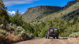
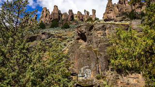
A quick breakfast of cereal and a towel to dry off the tent, and we were on our way. This section of road - Jarbidge Canyon - from the Idaho-Nevada border to Jarbidge is a great one. Winding alongside the river, interesting rock formations, an arch, and spires rise up along both sides. We were enjoying ourselves already!

We also made a quick stop along this part of the route at a painting of a Native American Indian in full ceremonial garb that we'd known about from our previous visit - the colors just a little worse for wear from the preceding winter.

Before long we were on the final approach to Jarbidge - the canyon opening up a bit - to reveal the green grass of spring time on the hillsides. Oh, and some snow!

Being mid-summer, we noted and dismissed the snow as we pulled into Jarbidge - I mean, surely we were late enough in the season that it wouldn't be an issue!


It's surprising to me that Jarbidge is as happening as it is, but the Inn/Café, Community Center, and fuel are all still there - keeping this little town humming along.
Jarbidge's name is an adaptation of the western Shoshone word Tswawbitts, the name of a horrible, human-eating evil spirit said to live in the Jarbidge Canyon. Tswawbitts was so huge he could step over mountains. He was said to carry a basket on his back that he stuffed with the people that he captured. Roadside History of Nevada


With over 700 miles in front of us, we didn't spend long before heading out - up into the Jarbidge mountains, the grade over 20% in some places.


It was here too that we got our first taste of spring wildflowers! In full swing, the hillsides were covered with a yellow blanket as we made our way up and out of Jarbidge.

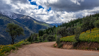
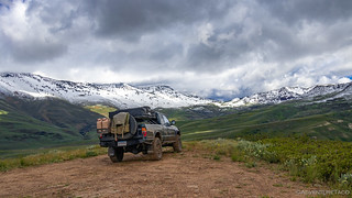
Up and up we climbed. At 7000' things were a bit wet but still normal, but as we passed through 7500', we discovered that even on the last day of June, these parts are still blanketed in the white stuff.


The snow was a double-edged sword - or perhaps more accurately, a blessing in disguise. The experience up here - with puffy white clouds in the sky, and the bright greens, yellows, and purples of spring pushing up through the snow on the ground, it was a feast for the eyes!
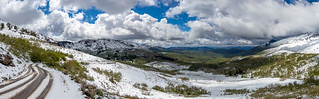

We crested the ridge at nearly 8500' and made our way slowly back down, the snow melt having turned the roads into a nice goopy muck, with even less traction than the snow itself! Oh, how I hate mud.

That was the last we'd see of the snow on this trip; an element of the adventure that could have stopped us in our tracks had we run the route a week earlier - and yet, also one that I knew we'd wish was with us as we (hopefully) completed the southern portion of our journey.

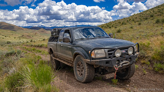
Without the melting of snow, the roads dried out quickly and we made good time on our journey south. As we did, the roads varied from well-groomed to lightly-travelled, the variety adding interest to the day.


Through the rolling green hills, we eventually found ourselves on the Wildhorse Mountain alternate - and purportedly more advanced - route, which I can only describe as "fun." While the going was slower, there was nothing difficult here, and the Tacoma enjoyed the little extra flexing that the overgrown-in-spots terrain offered.

Nearing the end of the alternate, a small, well-maintained cabin presented itself as @mrs.turbodb opened only her second or third gate of the day. Not sure if we should stop given how early we were in our journey, we ultimately decided that we were here, now - and so why wouldn't we?
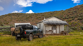

This approach - stopping as much as possible and not worrying about "staying on schedule" for the longer journey - is something that I think many folks have a hard time with. I know that I definitely struggled with it on my first several trips to Death Valley, and as I've gotten comfortable with knowing that I might spend an entire trip in one small part of the park, the trips have gotten much more enjoyable!
Looking back, we had no reason to feel rushed - it wasn't even lunch time yet, and we got another few miles in before our stomachs protested in earnest that it was time to stop when the next stare-at-it-while-you-eat view presented itself.

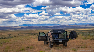
After a half-hour lunch of tuna sandwiches and potato chips we were back on road. I should note that this was our first time having tuna on a trip and it was delicious and easy given that we'd prepped it before leaving, and so just needed to spread it on bread and add lettuce and pickles. Highly recommended.
On the road, we were now in a bit of a transition zone between green rolling hills and the hotter high desert, meandering creeks making their way through the grazing land. Nothing to complain about from a views perspective, that's for certain!


Coming out of the mountains, we were starting to see more civilization. Where we’d only seen were roads, cows, and fences for miles, we now found ourselves bumping along next to new-fangled alien-looking high voltage power lines, their single pivot point and large head giving them a bit of an Area 51 appearance.

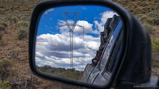
New-style towers can be air lifted into place and don't require level ground to deploy.
It was also at about this time that we found ourselves in a sticky situation, literally. As we came over a crest, the road plunged down into a low area that was still marshy from winter run-off. Extra cautious given our previous experience with mud, I got out to investigate with the shovel. The situation wasn't good. Shovel in hand, the entire blade easily plunged down into thick, gooey clay beneath an inch or two of water through which 2-foot tall grass was growing.
I could see where four motorcycles had attempted to cross, two with more success than the others. I tested it on foot, and my shoes would be muddy the remainder of the trip. Still, it was only about twenty feet across, and if we decided to bail on it, the re-route was nearly 40 miles - something we wanted to avoid.
So, I looked at @mrs.turbodb and asked if we were being foolish if we attempted to cross. "Yes," she said.
"I think we can make it with momentum," I replied and told her to hold on. She may have screamed a little bit as we blasted through, mud splashing everywhere but the tall grass acting as a bit of a carpet to keep us from sinking too deeply into the muck.
We made it! (And I have no photos). 
Not long after the muck, we ran into a deep ditch where erosion had clearly taken its toll on the road. I knew we weren't turning around, so with a, "We might have to do a little digging," to @mrs.turbodb I nosed down into the ditch. And then up the other side.
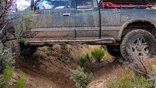
As the rear end eased down into the ditch I dragged the bumper, but that's why it's there, and the reasonably good approach and departure angles of tha 1st gen Tacoma made what could have been a shoveling situation, a non-event for the day!
Now, only a few miles from Elko, we looked at each other and smiled - surely the excitement was over, at least for the day.
But no, excitement is never really over on these sorts of adventures and as we rounded the next several bends, an interesting sight presented itself - a strange looking compound in the distance, surrounded by a large fence.

It reminded us of the compound we'd seen near Wickahoney in Idaho and never identified, and but even as we took a side road to try and get closer, we were stopped by a Private Property sign and locked gate.
In the end though, its front entrance turned out to be immediately off the highway (which we would be taking for a few miles from this point into Elko) and with that, the mystery - of this building - was solved!

 )
)From there, we putzed along the highway - keeping the speeds to 45mph given the fact that we were aired down - until we reached the outskirts of then end of our first stage - Elko, NV.
There, we fueled up - something one should take every opportunity to do on an adventure like this - and continued on; Elko might have been the end of the stage, but it wasn't the end of our first day on the trail!
The Whole Story


Interested in traversing entire states? Check out
More BDR's
for all the amazing routes we've run over the years.
Did you continue on past Elko mountain into spring creek to see the Ruby range?
We ended up going down south through Jiggs and then heading west (which I cover in the next part of the story). The Ruby's on on my list though for the future, and also checking out Lamoille Canyon, which looks spectacular.
Well then you saw the views I’m used to there in SC. You had to turn off the lamoille highway to get to jiggs unless you went the back way along the south fork river into reservoir.
We definitely had some great views of the Ruby's from our camp site. Check them out in the next part. Should be up in a day or two, and you can sign up here if you want to be sure to not miss it: Don’t miss the next adventure!
Next...
But first - how did you get out of that ditch?! 58”?!
Hi!
I was curious about the route from Jarbidge to Elko as it is posted on https://ridebdr.com/nvbdr.
Did you hit Highway 225 at the junction of North Fork Charleston Road, or were you on dirt until closer to Elko?
Just curious if the route is showing 60 miles of pavement to get to Elko, if there are other dirt trails that parallel the highway, or if you took a different route.
Thanks!
Hey J.D. ?, we did hit pavement there and rode it all the way into Elko. The reason for that - I think - is that a lot of the land through there is checkerboard, so it's hard to find a route where the (plethora of) landowners allow access. The good news is that you're not missing much up there, and the rest of the route is pretty awesome. Regarding the checkerboard - we ran into that on the Wyoming BDR this year, and I discuss it a bit here: Centennial to Elk Mtn - Top of the World - WYBDR 2. Hope that helps!