
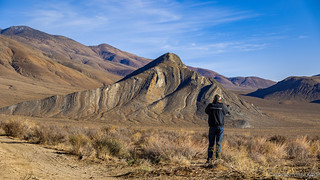
I've found no place in all my exploration of Death Valley National Park that I like more than waking up to a view of Striped Butte. You can imagine then - sleeping in our tents less than a mile away - that I had more than one alarm set in order to ensure my alertness when as the sun began to illuminate the sky.

With the skies clear after an evening of rain, and before the sun even crested the horizon, I soaked in one of my favorite sights in the world.
I spent nearly an hour hopping around behind, in front, and around camp - sometimes snapping photos, other times just watching from a momentarily comfortable rock - as the sun crept into the sky, bathing the mountain and valley with long orange rays.

First light on the hillsides, the sun still below the horizon.

Still asleep.

Nature's candy cane. Remember, these colorful layers were originally deposited horizontally.
It was - I'd later realize - the perfect start to a wonderful day. A day where everything seemed great on the surface. Just like it does in the eye of a storm. 
 Of course, now I'm getting ahead of myself.
As others began to stir, I took the opportunity to dig into the transfer case issue I'd noticed just before we rolled into camp the previous evening. Around the campfire, I'd theorized that the sounds I'd heard almost exactly three years and 100,000 miles earlier - and the resulting mud-colored oil I'd removed from my transfer case at the time - could have been the first indicators of a problem that had simply taken this long to surface again. Still, Zane @Speedytech7 and Monte @Blackdawg had suggested that I take off the J-shift, just to see if the problem was the bushing - an easy fix.

A few screws and bolts were all that was necessary to access the top of the transfer case. Unfortunately, it was in perfect working order.
Buttoning everything back up, eating breakfast, and putting away camp took another 50 minutes, and like clockwork we rolled out of our site just after 8:45am - everyone looking forward to the day ahead, and thankful that the less-than-ideal weather had tamped down the dust, making for much a much more pleasant caravan.
I wasn't the only one who was soaking in the views.
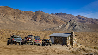
Not far from camp, we stopped in at the Geologist Cabin. While we could have set up camp at this location, I've always felt that the spot by the rocks is nicer, making the cabin a nice place to check out on the way into - or in our case out of - Butte Valley.
It's unlikely that our engines had even warmed up by the time we were parked again.

I'd wager that this is the most well-known, and perhaps the most nicely maintained, backcountry cabin in the park.

Did someone say Diet Caffeine Free Coke? Clearly, they knew I was coming!
Built in 1930 by Asa Russell (aka Panamint Russ), the cabin served as his living quarters as he worked a mine claim high up the side of old Manly Peak. An article, written by Russell himself in the April 1955 edition of Desert Magazine details some of his adventures in the area.
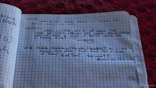
Left a little note for future explorers. Perhaps one day, they will find their way to this trip report!

Good advice, no matter where you may find yourself exploring.
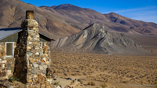
Even if there's a better place to camp, it's still hard to complain about the view.
From Butte Valley, we headed east. Our travels on this gorgeous day would take us through Warm Spring Canyon - stopping at several mines along the way - before dumping us out near the southern end of West Side Road. From there, we'd head north - exploring some of the more touristy sites the park had to offer - before finding camp somewhere in the Funeral Mountains.
Our first stop along this route was at Warm Springs Camp.

Lined up and - apparently - ready for Christmas.

The old Gold Hill Mill sits near the road near Warm Springs Camp.

An arrastra next to the mill. Ore was dumped into the stone lined trough and as the arrastra turned, large stones connected to the four arms were dragged over the ore to crush it.

Getting artsy with some of the mill's old components.
The history of Warm Springs Camp, the Warm Springs Talc Mine, and the Gold Hill Mill is not a pretty story.
In 1929, Louise Grantham - one of very few women in the mining industry - leased land from Bob Thompson, a local Timbisha Shoshone man. The springs were his ancestral homeland, but after signing a five-year lease and making just one payment, Grantham sued him for ownership.
With the legal battle underway, Grantham occupied this site and posted an armed watchman to guard against "trespassers." The courts eventually supported Thompson 's claim. For over a year, attempts were made to evict Grantham (including by federal marshals enforcing a court order), but she refused to comply.
Eventually, Thompson walked away from his claims. Grantham assumed total ownership and operated the most successful talc mine in the region until her death in 1969.-NPS
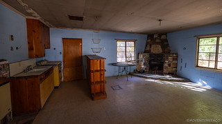
The interior of the mess hall, one of five main buildings that made up the camp.
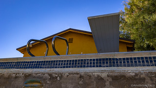
Grantham's personal residence was renowned for having the only swimming pool in Death Valley.
After looking around the buildings - and commenting on the rather shitty way in which this place transitioned to become the property of Louise Grantham - we wandered over to the entrance to the White Pine Talc Mine - an opening large enough to drive a truck into.
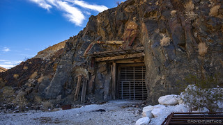
The wood framing that supported the entrance to this mine was sketchy enough that Mike @Digiratus was content to stay back while the rest of us peered through the steel bars, wishing we could squeeze past.

This shaft - seemingly supported by scraps of whatever the miners could find around camp - tunnels several hundred feet into the mountain.
Unable to go inside, Monte and I climbed 50' to an upper shaft - the remnants of an old generator and ore track still clinging to the side of the cliff.

Sometimes when you need a generator to pull ore carts out of a mine, the front half an old truck fits the bill perfectly.

Looking back up the canyon toward Butte Valley.
It was already 10:45am by the time we wrapped up our exploration of the Warm Springs Camp and continued to make our way east towards Death Valley. Just before reaching another of Grantham's Talc Mine sites, Monte spotted a group of Desert Bighorn off the side of the road. Naturally, any sense staying on schedule was thrown to the wind, and we stopped to watch as the animals scaled the steep terrain as though the footing couldn't have been better.

My first sighting of Ovis Canadensis Nelsoni in the park!

Neither of these two sheep were happy to have their photos taken.
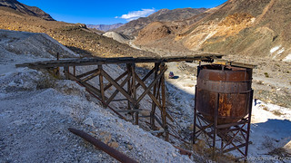
The loading bin at the lowest talc site along Warm Springs Road, the platform of the ramp towering 60 feet off the ground, and no longer stable enough to walk on.

Err... I didn't think anyone caught that on camera.
The last of the talc sites explored, we regrouped at the road and picked up speed as the surface became increasingly smoother as we exited the canyon and descended the alluvial fan into the valley. It is a grand entrance to be sure, the Black Mountains rising almost vertically in the distance, and yet the true scale of their prominence still completely deceiving.

Nothing like a 6,500' prominence to make you realize how tiny you really are.

"Now this is a shot worth taking." -Mike (and apparently everyone else)
With such a great view and reasonable temperatures - plus, knowing that there'd be very little, if any, traffic along this road at 11:30am on weekday - I suggested that perhaps this would be the perfect spot for lunch.

Anyone hungry?

All of us, apparently.
As we ate, we admired the view. To the east - obviously - the Black Mountains were the most prominent, but the view to the northwest was stunning as well - there, poking out of the clouds, was Telescope Peak, the upper elevations covered in a dusting of snow from the weather that'd rolled through the previous evening.

The snow on Telescope Peak wouldn't last long - it was completely gone by early afternoon.
After a leisurely lunch - with no traffic at all - and thoroughly enjoying our vantage point on the alluvial fan, it was time to continue down into the valley of death. We'd play tourist for the afternoon, checking out the sights that most people come to see when they visit the park. We'd start with the most famous: Badwater Basin.
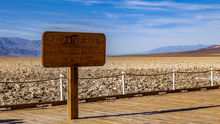
At 282 feet below sea level, Badwater Basin is the lowest point in the western hemisphere. Like most places below sea level, Death Valley wasn't created by erosion, rather, shifting of the earth's crust has dropped it to such a low elevation.

Only two inches of water falls to the Death Valley floor every year. The water near the boardwalk is produced by a spring, the water spoiled by the surrounding 200 square miles of salt flats.

A salt island.
From Badwater Basin, we made our way a few miles north and soon we were headed out into the salt flats, this time to wander our way through the Devil's Golf Course. Here, crystallized salts compose jagged formations of a most forbidding landscape. Deposited by ancient salt lakes, they are shaped by winds and rain, the formations ever changing.

Walking out into the salt formations is a strange experience - the entire landscape is both delicate and as hard as a rock at the same time.

Tiny tendrils rise up out of the salty surface.

Away from the trampled main routes, delicate salt arches reach for the sky.
Continuing north - the early afternoon sun of this most pleasant day to our back - our time on Badwater Road was short, a detour into the northern end of the Black Mountains the final touristy spot on our days agenda.

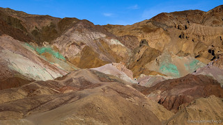
Headed into the colorful hillsides of Artists Palette.
I think the best way to enjoy the stunning colors - the result of volcanic deposits rich in compounds such as iron oxides and chlorite, which creates a rainbow effect - is to park and hike into one of the many narrow canyons, or into the palette itself. For us though, a few stops along the road, and at the main overlook would suffice - not that we had anything to complain about except the crowds.
Someone spilled their mint ice cream on the hillside.
Having enjoyed the mainline attractions, but ready to get back out of the crowds - if a couple dozen people can be called crowds - we pointed our Tacomas toward the hills and began our 10-mile trek into the Funeral Mountains by way of Echo Canyon.
Like Gohler Wash - and Titus Canyon before that - a few rocky sections help to keep the riff-raff at bay, but in general, the lower section of Echo Canyon is a relatively easy drive as long as you have the right vehicle. And on this trip, we wouldn't be tackling the much-more-difficult-upper section at all, so we leisurely wound our way between the soaring walls, stopping now and again to capture particularly photogenic formations.

Back on dirt and headed toward camp!
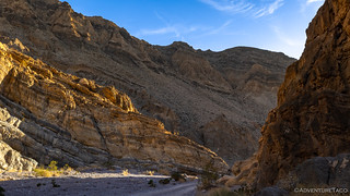
Afternoon sun streamed into the canyon, the long low rays adding a glow to fingers reaching down into the wash.

Oranges contrasted with blacks as we wound our way toward camp.

Halfway to our destination, we made a quick stop at the Needles Eye Arch.

Rainbow uplift.
Our day almost done, I called out over the radio that we'd soon be passing the Inyo Mine. Knowing that getting to camp while it was still light was high on the list of priorities - especially given our late arrivals the last couple of evenings - I mentioned that we'd continue on to camp, and then anyone who was interested could drive back to check it out.
I took the silent response as a hint: I might be the only one turning around for a look.
We reached camp just before 3:45pm - a full 45 minutes before sunset, and a good 90 minutes before dark. At the end of a road and the edge of wilderness, we all - myself included - set up our tents, the lure of a relaxing evening outweighing the draw of the Inyo Mine. We could - I realized - visit it on the way out in the morning.

As the sun eased below he horizon, calm pinks and purples illuminated the clear skies above. A glorious end to a beautiful day.
Once again, we'd covered a lot of ground, seen some of my favorite sights in the park, and we'd done so without a single worrisome noise from the underbelly of my Tacoma. Suffice it to say, it'd been a great day. Not only that, but the next two promised to be just as wonderful - our route taking us to Eureka and then Saline Valley.
But then, I find that it's rare that anything ever really goes to plan...


Excellent write up! Gave me a nice break from my work from home monotony.
Awesome, glad you enjoyed it and that it can give you a bit of a break - I certainly know how important breaking up the monotony of email can be! There's always more to read of course, and I hope you find other stories just as enjoyable! https://adventuretaco.com/index/destination.
Thanks again Dan for your wonderful post of information and photos. The abundant colors surrounding every turn are breathtaking. The photos encourage me, even more, to get with it and get an adventure rig.
Safe Travels!
Thanks Kenny! Hope you find that rig soon, and always happy to help with the search.
Loved Echo Canyon! Spent two nights there...at the beginning and end of our Death Valley experience.
Thank you, Dan!
Very cool! Where did you camp in the canyon? I think most people camp closer to the entrance, but I've always tried to get as far away as possible. My favorite area is in the upper canyon, but that requires quite a bit of work to get over the dry fall - more than most rigs can handle. Still, highly recommended if you can swing it!
We camped about 4 miles in. Just past the 1st bends where the canyon walls narrow. We were secluded...up against a canyon wall. Nice spot. Not as far as the mine. But we were tired from the long drive from Phoenix. I'd send a picture but don't see how from here. This was my first outing. Had a truck bed tent. It worked....but....lol.
I'm now set up with an overland tent on a rack over the truck bed. Much nicer!
Truck still stock.
Striped Butte has gotta be one of the most soulful views in all of North America. Wonderfully photographed by turbodb. Thanks Dan...!
Another awesome trip report! I visited Butte Valley and hiked up Stiped Butte a couple of years ago... looking forward to visiting again, but Eureka Dunes is next on the list... the history of Warm Springs between Louise Grantham and Bob Thompson piqued my curiousity. Lots of fascinating details in this document from the library of congress website in case anyone else was interested...
http://lcweb2.loc.gov/master/pnp/habshaer/ca/ca3000/ca3003/data/ca3003data.pdf
I completely agree with your assessment of standing in the presence of the Stripped Butte. One senses one's place in the scheme of things. At least I did. I want my ashes scattered in front of the Geo facing the Butte in all her majesty. Watching the sun come up every morning, and go down lighting up those magnificent stripes. As I've said before I need to get back there. Cheers.