
In all of our exploration, we've done relatively little in our home state of Washington. Partly, this is because the weather window here is relatively short each year; partly, it's due to our desire to explore lands further afield; and partly it's due to the landscape.
Western Washington is so wet that finding a route that is more than simply a tunnel through trees can be challenging. Roads are quickly overrun with brush, structures rot away in the blink of an eye, and with much of the land owned or leased by logging companies - the roads are gated and locked, "for safety."
Still, I've always wondered if we could find something amazing in the far west of our state. There is - after all - an entire National Park, surrounded by a National Forest, on a peninsula larger than many states. And so, keen to satisfy our curiosity, we set our sights on an Olympic Traverse.
Unlike 98% of our trips, this one wasn't going to require 20 hours of driving just to reach our starting point. In fact, less than an hour after loading up in the Tacoma, we were aboard a ferry that would shuttle us across the Puget Sound and onto the Olympic Peninsula.

Unlike Inland Ferries in Canada - which I enjoy every time I experience them - these are most definitely not free.

The MV Spokane was looking fine under mostly clear blue skies as it carried us from Edmonds to Kingston.

As we sailed across the sound, we passed the MV Puyallup, and the Victoria Clipper speeding to the north.
Disembarking just after 8:30am, we covered the last few miles of pavement before arriving at our entry to the loop that would be our Olympic Traverse. As with all well-laid plans, ours - to complete the loop in a counter-clockwise fashion, starting and ending in Quilcene - would soon be foiled, but for now, we dove into our first tree tunnel, eager for the road ahead.

Our route would take us along more than 750 miles of roads around the peninsula.

The vast majority of that distance would become monotonous, as the tree tunnels seemed to never end.
As we wound our way through the first 50 miles of trees, the landscape took an early toll on both of us. I wondered whether there'd be enough attractions along the way in order to keep us occupied, as @mrs.turbodb dozed in the passenger seat.

Eventually, a small break in the trees afforded us a still-partially-obstructed view.
(I had to stand on the tent just to get this photo.)

Even elements that wouldn't normally have held our attention were welcome variety along the way.
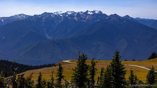
Despite the shady start, it wasn't all that long before we found ourselves at the Hurricane Ridge entrance to Olympic National Park where we picked up a new America the Beautiful Pass and began the long climb towards the tree line. We'd spend the entire rest of our day exploring the highest roads and trails of the trip, in an area which, for me, encompasses the best views that the peninsula has to offer.

Climbing up out of the trees, we finally got a taste of the Olympic Mountains.
The only problem - if you could call it that - was our arrival time. I'd hoped that we would arrive later in the afternoon so that we could camp at Obstruction Point before going for an early morning hike along Lillian Ridge to kick off day two. However, as we pulled into the parking area on Hurricane Ridge, it wasn't yet 1:00pm; it was way too early for us to stop for the day!
After a quick discussion, we decided on our first - of many - adjustments to the plan. Rather than tackling the 5-mile hike along Lillian Ridge the following morning - when I'd hoped for cooler temperatures and light pouring in from the east - we'd hike the trail in the evening, capturing sunset along the way. Even then, we had several hours to burn, so we decided that a quick hike up Hurricane Hill - and then a mid-afternoon nap - would be a fabulous way to pass the time.

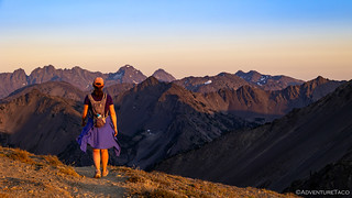
As we set out towards Hurricane Hill, the views couldn't have been more magnificent.

Glaciers - receding quickly - still dot the upper reaches of the Olympic Range.
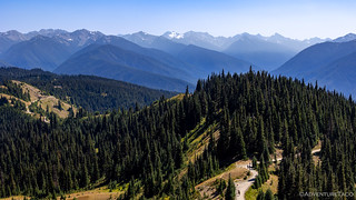
At 3.5 miles roundtrip - a mere 2.5 miles longer than we'd expected  - the Hurricane Hill hike is one of the more popular hikes in the area as it affords 360° views - of the Olympics as well as the Puget Sound - almost the entire time.

This trail is not one that can be called "remote," though we could tell that the 700 feet of elevation gain did take their toll on many of the hikers.

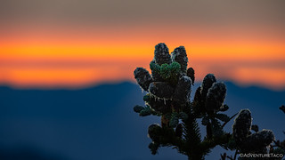
Sticky cones of the subalpine fir.
Gazing west, our views only improved as we gained elevation.

As we reached the summit, Ediz Hook and Canada stretched out to the north.

To the east, Mt. Angeles was significantly lower than the ridges to the east, but its proximity made it the most prominent peak around.

"For information, write the director, Washington DC."

This little guy - and a bunch of his buddies - were enjoying the afternoon just as we were.
In no rush at all, we spent a while at 5700', admiring the landscape as it stretched up and down approximately the same distance. Even at this elevation, temperatures were over 80°F, and after soaking in the views we decided to head back the way we came. It was time to leave pavement behind and find a spot to open up the tent for an afternoon siesta.
If anything, the views on the way down were even better than they'd been on the way up.

From the Hurricane Ridge Visitors Center, we headed out the road to Obstruction Point.

Majestically glorious views.
It was just after 3:30pm when we found ourselves in the Obstruction Point parking area at the trailhead for Lillian Ridge. With sunset slated for a little after 7:30pm, we had a few hours before blast-off, so I setup the tent and we climbed up for a little reading, shut-eye, and shade as various folks came and went from this relatively popular trailhead.
I think I was more relaxed than @mrs.turbodb during this process, and at 6:15pm she poked me awake, wondering if it was time for us to go. I still thought it was a bit early - thinking it wouldn't take us all that long to do a five-mile roundtrip hike, if we wanted to catch sunset along the way - but after a few minutes we climbed down out of the tent. After gathering up our headlamps, water, and our plethora of electronics, we headed up onto the ridge and into the Olympics - a warm evening hue lighting the way.

Onto the ridge.

Almost immediately we ran into a family of grouse poking around in the tall grass. Stand still, grouse!
For the most part, the first three-quarters of the out-and-back trail was easy going. Mostly uphill, the trail gained 1,700 feet over its length, but nothing seemed overly difficult and of course the scenery was second to none. Towering ridges, distant lakes, and long shadows were everywhere, the sun orange as it streamed through a hazy sky to the west.

Layers of ridgeline, all of them, roadless.

Just below the ridge, our trail passed through green, brown, and even a little white as we climbed higher into the wonderland.
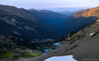
Below us, lakes - best viewed from afar due to the millions of mosquitoes - sparkled like jewels.
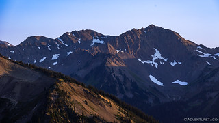
Scarce amounts of snow, even on the northern faces.

Even as the sun was still reasonably high, a hazy orange hue on the horizon backstopped the smokey blue landscape.
As the minutes ticked by, we pushed on, the temperatures getting more and more pleasant as the evening progressed. I didn't know it at the time, but @mrs.turbodb was really worried about the hike back. Having talked about seeing sunset on the trail - and having packed our headlamps - it seemed obvious and by design to me that we'd be heading back in the dark. To her though, finding our way along the trail - navigating the undulating terrain - was not high on the list of "fun."

She can see what we cannot. Until...
Splendor.

Headed to the large patch of snow in the distance.
Eventually, as we climbed through some steeper, rockier, and all-around sketchier stretches of trail, we began to have a discussion about just how far we intended to go. With only a few minutes until sunset, we'd clearly be reaching the high point of the ridge after the flaming ball moved below the horizon, and with a narrow scree trail between us and that point, @mrs.turbodb wasn't sure that was such a good idea.
In the end, as much as I wished we'd reach the high point of the trail, I realized that the trade-off of forcing us to push onward wasn't going to be worth it. Instead - to enjoy these last few minutes of light as much as we could - we made our way to a rocky point that afforded us 360° views that were probably just as good as any we'd see.

Shadows were quickly creeping up the hillsides as the sun neared the horizon.

The sky behind Mt. Olympus seemed to catch fire before our eyes.

Won't be long now!
Subalpine fir, dripping into the night.
Turning around, we began to retrace our steps - the light seeming to change more quickly with each passing moment. We'd entered the magic hour - that time when shadows no longer cover the land, and the sky puts on a show of its own. As one of us pushed to move quickly before dark, the other slowed down to snap photos.
Frankly, it was a recipe for disaster.

Looking back as we retreated from our goal.

To the south, the new moon wasn't far behind the sun as it raced towards the western horizon.

Setting into a sunset.
Having hiked for nearly two hours at this point, the last of the light faded from the sky during our 90-minute trek back to the Tacoma. Eventually, as even the ambient light wasn't enough to illuminate the trail, our headlamps came out, ushering us the final half-mile or so.

Past green grass and snow drifts.

Under a stary sky.
After a couple - what turned out to be fantastic - experiments with long exposures, the frustrations we'd both felt along this hike boiled over. Each of us felt that we hadn't got what we wanted, and as happens sometimes, the situation overheated.
And with that, we were done with the trip. Our week in the Olympic Peninsula cut short to a single day, it was time to head home.

Of course - despite the unfortunate events on the trail and the ensuing battle on the long drive home - we'd eventually work through the frustrations and find ourselves wondering what we'd left behind.
Surely there was more worth seeing, and so a few days later we set out again. Back to complete our traverse through the Olympic Peninsula's Passages.


I'm so glad you two pushed through the conflict. Never leave a conflict to fester and brew! Thanks for the honesty in the post and beautiful pictures to go along with them. Relationships take work and I appreciate you showing a little bit of that here.
Thanks Brian, initially I wasn’t sure how to write this story, but in the end, I decided that – as you mention – all, relationships experience arguments, and as much as Instagram would like us to believe that everything is always perfect, there’s not really any reason to hide reality. Ultimately, when we read this story a few years from now, it will be good for us to remember that everything isn’t always happy go lucky, and yet still always tends to work out.
Hope you enjoy the rest of the trip as well, as I get it posted! ?
Yes, the area is beautiful. I had a sister who lived in Quilcene and visited a few times so am familiar with the area, Sequim, Port Townsend, etc. Their home had water frontage, lots of forest, but the winter could be brutal. I'd love to see the area again but it's a very long drive from down here in the Mojave and, as you said, the season is very short so doubt we'll ever see it again so I'm thankful for your photos and narration!
That's a beautiful area - your sister was lucky to live there (except for the winters, as you note, which can be long and cold and extend until... July! ?)
Glad as always that you enjoyed the story. Lots more - and more "typical rainforest" coming in the next parts.
If we don't have some difficulties once in a while we tend to forget how good the good times are.
I am proud of you both.
God bless!
Kenny
Thanks Kenny! Difficulties are part of life, for sure! I'm hoping for maybe one more trip down to SE Oregon in a couple weeks. Just have to hope that the weather clears up (right now, rain is predicted, but we both know that the weather guessers are just tossing a coin for forecasts two weeks in the future). Will find somewhere else to explore if it's wet though. No need to get that mud on *everything*!
Safe travels!
I read your blog. Now heres the crux of all your problems and worries - a schedule. Schedules ruin all adventures.
LOL, I know what you mean! Luckily, our schedules are just "suggestions" of the things we want to see, or general times of day we want to be in a place for some specific lighting or whatever. We never really stick to them, and more often than not, we find ourselves doing something completely unplanned! For a great example of "Schedules, what are those?" check out this trip we took to Death Valley at the beginning of the year. ?
Hope you enjoyed the story and will come back for the rest of the trip! ?
Stunning photos and inspirational area. Like posters above, I appreciate the honesty that so often gets replaced or hidden from others behind endless beautiful scenery and exploration. Glad as well that cool heads prevail and that we can continue to expect more great runs and tales in days to come
Thanks Holly - glads you enjoyed the story and photos as always! Open lines of communication can work through pretty much anything - would be great if society as a whole could get back to that way of thinking/operating/interacting. So much "us" vs. "them," that we have a hard time stepping back and realizing that we're mostly the same.
America the Beautiful. You both see it and bring us along for the ride. Thanks for capturing parts most will never see!!
You're always ?% welcome Bill. So nice to have regulars along to enjoy this stuff with us.