
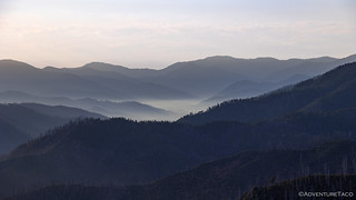
Having gone to bed with smoke so thick that we could barely see the mountains a few hundred feet away, and wondering if the smart move would be to head home rather than push through the remainder of the Siskiyou Crest Adventure Trail, I let out an audible whoop as I unzipped the tent door to greet the morning light.

At some point during the night - I couldn't tell you when since I'd zipped up all the doors of the tent to keep as much of the smoke outside as possible - the wind direction shifted nearly 180 degrees. Blowing the pea soup out to sea, it resulted in the clearest morning of our trip, and certainly lifted our spirits as we prepped for our six-mile hike to Pearsoll Peak, the highest in the Kalmiopsis Wilderness.

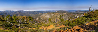
Following what we'd later discover was an old mining road, the trail wound its way along the Kalmiopsis Rim, gaining elevation at a constant - but reasonable - pace. All around us, views extended for miles farther than we'd been able to see the day before, and our heads were on a constant swivel as we soaked it all in. I can't convey the sense of glory and relief I had, especially after my apprehension the night before.

We expected the road to deteriorate as we climbed, but to our surprise, it was in good condition - even actively maintained - in areas that would naturally wash out due to the presence of drainages and springs that were still sending water down the mountain.
We'd discover the answer to this mystery later, but for now we wondered if we'd somehow missed the route that might have allowed us to engage in some good old-fashioned "American Hiking." You know the kind with a skinny pedal and 4WD.

Of course, we were enjoying our time on foot, as we'd had plenty of driving over the previous two days.

Around each of the springs - and as far as we could see along their waterways - life was abundant. California Pitcher Plants seemed more spectacular than the curated display we'd seen the previous day. Wild blackberries - smaller and more delicious than the Himalya variety found in supermarkets - were perfectly ripe. And orange tiger lilies dangled daintily over the rushing water, all manner of pollinators partaking in their bounty.


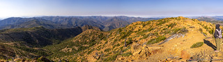
We passed five springs - the only ones along the route - in just under a mile. From there, the trail leisurely switched back and forth a couple times, our rate of elevation gain nearly constant from the time we left camp to our emergence on a narrow ridge where we got our first glimpse of our destination.


Across the ridge, the road crossed a scree field. This was the first place where it started to seem a little sketchy - not due to width, but because the lower track had started to slide down the hill over the years and it was reasonably off camber. Passable? Perhaps. But, "it wouldn't be fun backing down this section if there's nowhere to turn around," I remarked to my hiking partner to copious nodding.
And then, maybe 500 feet beyond the scree field, we reached the end of the road. From there, nothing but a footpath continued on to the lookout, still more than 500 feet above us.
It wasn't obvious at first, but as I glanced around - wondering why the road ended at this particular location, I realized that we were standing at the bottom of an old ore chute. Above us - and below it would turn out - adits plunged into the mountain, discarded waste rock well-camouflaged by the already-crumbling hillside.


Having identified tailings piles a hundred feet up the hill, we had a couple options - the easiest would be to ignore the possibility of an explorable adit and continue on up to the lookout. The funnest (that is a word), would be to scramble up the hillside to investigate.
We decided to do both - in that I started scrambling, and @mrs.turbodb called up to find out if I'd discovered anything interesting.


After describing the situation with the collapsed adit - and having watched my slippery ascent up the scree-covered hillside - @mrs.turbodb decided that she was good down on the trail, but surprised me by asking a question that I hadn't even considered:
"Do you want to just keep climbing up to the lookout from there, while I take the trail?"
My answer should have been obvious and quick. After all, I'd just seen the lookout as we'd walked across the ridgeline saddle. But, looking up the crumbling hillside, it seemed like it might be doable to pick my way up. Pulling out my route navigation device - an 8" Lenovo Tab M8 FHD that works really well with the topo maps on Backcountry Navigator XE - the ascent didn't seem that much worse than the ascent of the trail, so I decided to give it a go. Assuming it worked, I'd have only about a quarter the distance to travel as my companion, and I wouldn't have to find a way back down to the trail.
Now, before I continue with the story, I feel it is important to highlight two elements of that last sentence.
- "Assuming it worked" - we all know what they say about "assume," but in this case I was the only one involved. So, perhaps I was twice the (dumb)ass that I might normally be.
- "I wouldn't have to find a way back down" - even from my current position, I was already concerned about downclimbing my way back to the trail. What idiot would continue up when running into an impassable section above would necessitate going even farther back down. Oh, right, this guy between the keyboard and screen.
Hindsight of course is 20/20, and as I climbed up the next hundred feet, I quickly realized I'd made a mistake. Unfortunately, this is where point #2 came into play. Plus, knowing she had a longer distance to go than I did, @mrs.turbodb was nowhere to be seen as I started picking my way down the loose, 65 degree slope.
It only took a descent of about 15 feet for me to realize that "down" was really not an option.
And so, up I went, grabbing every piece of vegetation I could, testing each crumbly piece of Serpentinite before transferring my weight. It was slow going. I cut my hand on a rock. The wind picked up as I skirted a narrow ledge. I was dumb enough to let go of everything so I could snap a couple photos.

Eventually I reached a shallower ridge leading up to the lookout. I'd survived. I quickened my pace in the hopes that I could at least salvage a win by reaching the top first. And then @mrs.turbodb popped her head around the lookout and asked me if I was OK, adding, "My route was amazing, through the most beautiful garden-like setting."
I just smiled - a mixture of defeat and success - as I climbed up the final 15 foot ledge to the lookout.


Initially, as we walked around the exterior, it appeared that the lookout was all locked up. We'd expected as much from the descriptions we'd read, knowing that - at the very least - it had been abandoned as an active lookout sometime between its installation in 1954 and its restoration by the Illinois Ranger District and the Sand Mountain Society in 1994. In fact, prior to this building, a cupola-style lookout was erected onsite in 1920, as reported in the local paper:
We have at last completed the Pearsoll Peak Lookout house; it is one of the ready cut standard type and it sure is a real house. We bumped up against a few minor mistakes which caused not a little grief, for instance, the plans call for tower windows size 33 1/2" x 38" but when we came to fit the windows we found they were 30"x38". A lot of swearing naturally followed. Further, the bevels on the quarter round were all cut only on one side; four of the jack rafters were four inches too short. Most unfortunate, while the table for the fire finder conforms exactly to the specifications, it is at least 14" too low. On a downward slope of 45 degrees or more, one could never sight the base of a fire looking through the sights of the alidade.July 1920, Siskiyou Bulletin
Then, as I more closely inspected the steel bars securing the shutters, I noticed that they could be lifted out of the way without the need for a key, allowing the shutters to be raised and the door to be opened. A few minutes later, we were inside!


After poking around in the pile of tools for a few minutes, we stashed the documentation back in the tupperware we'd found it in and retraced @mrs.turbodb's steps down from the summit.

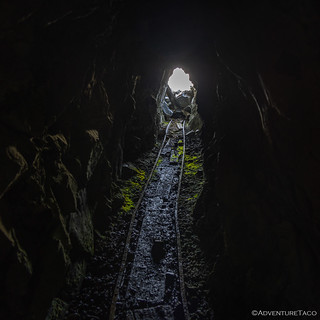
We couldn't come all this way without inspecting the lower workings of the Pearsoll Peak Chromium Mine, and a few minutes later our curiosity paid off - a second adit, this one leading much deeper into the mountain.


After venturing a few hundred yards into the mountain, I'd had enough. I can't be certain, but the tracks in this adit suggest to me that it was likely connected to the adit further up the hillside that I'd explored earlier in the day via a vertical shaft. Ore would be sent down the shaft and then moved via ore cart to a truck waiting at the entrance.

It was a lot of fun exploring the mind, but @mrs.turbodb was relieved when I mentioned I was ready to go. Unlike me, she's not dumb enough to climb herself into places she can't climb down, or venture into adits that are "totally safe."


We reached camp just before 11:00am, both of us ready for lunch after our morning workout. And, with only about 60 miles of Siskiyou Crest Trail remaining, we decided that we might as well eat the tacorittoes we'd planned to have for dinner, easy to do since the Tacoma was still set up in camp.
Then, just as we were about to light the stove, I caught movement in my peripheral vision. Two hikers - their packs stuffed to the brim - appeared from the west. There was a trail into the Kalmiopsis Wilderness there - though not one I'd have considered hiking, and it turns out that our new friends were just as surprised to see us parked at the pass as we were to see them.
After warm hellos, we each shared our stories - these two, part of the Siskiyou Mountain Club, an organization that maintains all of the hiking trails in the region. They'd camped with a sizable group far below us the previous night, and were hiking their way along the Kalmiopsis Ridge Trail to shuttle two vans that we'd seen at the wilderness overlook we'd visited the previous afternoon.
Turns out that the woman in the group - whose name I've forgotten but starts with a "K," was the "K" of "N+K" in the Pearsoll Peak Lookout logbook, having visited nearly a year earlier!
Seriously, what are the chances?
After a few more minutes of chatting - the SMC folks extremely interested to hear about the road conditions we'd encountered in reaching Chetco Pass via mechanical means - we all bid each other well and settled back into our routines.


Upon reaching the river, there was only one thing on our mind - cooling off with a dip under the suspension bridge we'd passed on our way in the previous evening. Donning our swimsuits - one of us eased her way into the water, the other diving headfirst into the pleasantly cool pool.

Refreshed, it was just a few minutes after noon when we stashed our already-almost-dry gear in the back of the Tacoma and began our climb up, and then along, the Illinois River towards a water crossing of Briggs Creek and the closest we'd get to the still-only-17%-contained Flat Fire.


We initially thought that these plants were skunk cabbage when we saw them without blooms, but they are apparently a corn lily (Veratrum californicum), and extremely toxic.
As we rounded a bend near Flat Top Mountain, we caught a glimpse of smoke rising from the southern leg of the Flat Fire. As I got out to snap a photo, @mrs.turbodb pulled out her binoculars and spotted two helicopters working the area, each of them releasing load after load of water onto the flames.

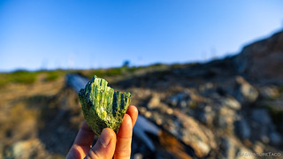
It was 2:30pm when we embarked on the final leg of our route. Chrome Ridge Road derived its name from the ore mined here during World Wars One and Two - the same chromium that miners at Pearsoll Peak had tunneled into the hillside to retrieve - which was used to create a hard, rust-resistant armor for battleships and tanks.
Since that time, loggers, miners, the Civilian Conservation Corps, and the US Forest Service have used the Chrome Ridge Road as a major thoroughfare, a fitting end to our travel through the region.


Within a few minutes of airing up we hit pavement in Galice, Oregon along the banks of the Rogue River. From there, we followed the mighty Rogue east, eventually flowing into a sea of cars making their way north on I-5.
It'd been a great introduction to the Siskiyou, and I'm sure it won't be long before we return.


REALLY ENJOY UR PICS AND ADVENTURES. I LOVE TOYOTA'S TOO. HAVE TWO TACO'S AND A GAS GUSSLING TUNDRA. HAVE OWNED TOYOTA'S SINCE 92. WON'T BUY ANYTHING ELSE. BEEN LOOKING AT UR PICS AND ADVENTURES FOR SOMETIME. LIVE IN DESERT IN SOUTHERN CA. (JOSHUA TREE). DO ALOT OF HUNTING IN AZ, NV, UT, NM, KS AND CO. KEEP UP THE GOOD WORK. WONDER IF WE WILL EVER CROSS PATHS. IF U SEE A CAMO TACOMA THATS ME. GOOD LUCK, BE SAFE AND KEEP UP THE GOOD WORK.
Glad you're enjoying the stories and photos Jeff! You're in a great place down there, with some interesting weather this summer, ehh? I've spent a ton of time in Death Valley, but just made my first trip to Joshua Tree earlier this year. Also really enjoyed the Dale Mining District! Was a bit crowded in the park (along the roads) but I did very much enjoy getting off onto the (lesser travelled) trails and seeing some of what there was to offer. Will certainly be back, and hope to spend more time there this fall/winter/spring, especially if DV remains largely closed.
THANKS FOR RESPONDING TO MY POST. JOSHUA TREE HAS BEEN PACKED FOR THE LAST FEW YEARS. I WILL BE HONEST, TRYING TO GET OUT OF THIS STATE AS FAST AS WE CAN. WAITING FOR HOME PRICES TO GO BACK UP AND PERCENTAGE RATES TO GO DOWN. LOOKING AT IDAHO, NEVADA, ARIZONA OR LIKE STATE. LET ME KNOW WHEN UR BACK THIS WAY AND MAYBE WE COULD MEET TO SAY HELLO AND SWAP STORIES. I'M RETIRED UNITED STATES MARINE AND RETIRED SAN BERNARDINO SHERIFF'S DEPUTY. 21 YEARS IN THE CORPS AND 21 YEARS DEPUTY. BE SAFE OUT THERE AND KEEP TAKING THE GREAT PICS.
Would you mind emailing me where you crossed Brigg's Creek id like to drop a pin there for my google maps. Great trip report this is an area I've not thought about traveling to until now.
We are thinknig of doing this trip in July. Is this trip do able pulling a small "adventure" trailer w/ a jeep? Great pics btw.
Hey Josh, When you say "this trip," do you mean the full Siskiyou Crest Adventure Trail (Aug 2023), or just this bit to the Kalmiopsis Wilderness? In general, pulling a small trailer should be fine on the larger trip. Heading up to the Kalmiopsis will be a bit tight in places (with a lack of turnarounds until you get to the top) but should also be doable with a bit of skill.
The one thing to be aware of at that time of year is snow at elevation. If there's snow, I wouldn't head up to the wilderness with the trailer! Have fun out there!
Just the Siskiyou trail...We'll be going mid july..Thanks for the feedback