
When I'd marked the spot we camped in Valley Wells, I hadn't really done any research on it. I knew it was on a road that would take us to the Copper World Mine, and I'd seen what looked like some ruins during my route planning in Google Earth, but that was the extent of my research. Shoot, I didn't even know that it was called Valley Wells! 
What I did know when we went to bed though was that we were well positioned for a colorful sunrise - if some clouds showed up overnight. Lucky for us, they did, stretched all across the southern horizon and above both the Clark and Ivanpah Mountains.


I'd been up for 45 minutes or so when the sun finally peaked above the horizon at 7:05am, and I'd waited till then to start exploring the area - my curiosity piqued by the little bit of looking around I'd done during sunrise.
It turns out that Valley Wells is the site of several historically interesting remains, which @mrs.turbodb related to me from Hiking the Mojave Desert. The smelter here was constructed in 1898 to process ore from the Copper World Mine - the next place we planned to go explore!
Today, there are only foundations and a slag pile left over from the smelter that worked from 1899-1904 and 1917-1918, but they are still interesting to explore. The foundations have been vandalized as is often the case with easily accessible locations, though the artwork is eye catching.


The slag pile on the other hand, looks mostly untouched. Having not read any details about it when we were there, we initially thought it was some sort of volcanic flow, it's surface glossy and glass-like, similar to obsidian. However, it turns out that this is actually a mixture of iron, copper, and calcium silicates that was the "waste" from the smelter. As it was poured, it cooled rapidly into what is essentially a metal-rich glass. If you visit this site, refrain from walking on the slag piles, as their glassy surfaces are very brittle, and doing so destroys them over time.

While in retrospect, the slag pile seems the most interesting part of Valley Wells to me, at the time I was more intrigued by the troglodyte ruins that are visible along the banks of the wash system that weaves its way through the site.

These dugouts were used by the miners in the Valley Wells community who noticed that the top layer of ground in this area was harder than the layers under it. They then excavated one perfectly rectangular room at a time to create dwellings, many of the rooms containing amenities such as nooks for shelves, and even chimneys. While many are in various states of erosion, they were definitely a cool thing to wonder about as we looked around.


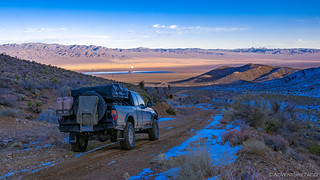
By 8:15am, we'd completed our exploration - for this trip anyway - of Valley Wells, and were headed east from Valley Wells to the mine from which the vast majority of its copper ore had originated - the Copper World Mine in the southern folds of the Clark Mountains.

While not a difficult road, we still weren't sure what to expect given we'd be reaching elevations of 5500', but we were relieved to see that the hillsides seemed to be mostly free of snow - or at least deep snow. After about five miles we reached the bottom of the massive pile of tailings - nearly 200 feet tall - which was where the truck would stop and our hike would start.

The Copper World Mine was the East Mojave's richest copper property, and it's clear with even just a cursory glance that there is a lot of copper still left at this site after it was worked from 1898-1918. To get a closer look - and and because we wanted to do a little exploring of other mining claims on the other side of the ridge - we made our way up the tailings pile as quickly as possible, which is to say slowly given the many stops to check out all the ore.
And then, as we neared the top, all the stops and bits of green we'd seen suddenly seemed like the minor leagues. Here, the entire side of the hill was green, shafts all around indicative of the riches that lay within the mountain. It was stunning.


While the tailings of the Copper World Mine are obviously still quite evident, unlike other sites where various human debris seems to be scattered across the landscape, there were no buildings or machinery that we could find. We knew however that just on the other side of the ridge - in the next wash over - were the remains of the Copper Commander Mine, so that's where we headed next.
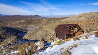
Not as successful as the Copper World Mine, the tailings of the Copper Commander were much smaller and split into four distinct levels leading up the side of the mountain. At the bottom, an old cabin - recently (in the last 6 years) reduced to just a roof when the walls collapsed - an ore chute, and the frame of a collapsed mine shaft dot the landscape. The wood used to build these structures may be crumbling, but judging by the nesting materials inside, they are still providing shelter to many a small animal.


There's a nice loop hike from the Copper Commander Mine to nearby Pachalka Spring, but that's something we'll have to explore next time - for on this trip we'd planned to head back over the ridge and tailings pile that we'd climbed to get here in order to visit a third copper mine in this area - the Dewey Mine.
The Dewey was on our list because of its relatively unique tram that lowered copper ore nearly 550 feet down the mountain side to a stone loading platform at the end of a steep mountain road. This structure was an engineering marvel at the time, and though the lower half has collapsed, it's easy to see how it made material removal significantly easier for the miners.


The mine shaft at the top of the Dewey mine is still accessible, and appears to be in reasonably good shape. It's hard to see here, but the ceilings are nearly 12' tall in the lowest areas, and the maze of tunnels here is one of the most complex in the preserve. It, along with several other shafts we'd seen on this trip left me wondering if it might be worthwhile to learn a bit more about exploring these dark wonders - something even fewer people do, and so perhaps even more special.

With that, we bid farewell to the Copper World Mine area and headed north. Our destination was Alaska Hills - a place I'd planned for us to spend the first night of the trip, when we'd been stopped by snow on our way up to the Colosseum Mine.
To get there, we'd make a clockwise loop up Excelsior Mine Road to a power line road that heads east. All I can say is that this route was torture. I've previously named both Cottonwood Canyon Road, and then Saline Valley Road in Death Valley as the worst washboards ever. Both pale in comparison to the conditions we encountered on the power line road. Even speed wasn't our friend here, and we ultimately decided to air down even further and drive slowly.

After an excruciating six miles that took upwards of 30 minutes, we were relieved to turn south into Alaska Hills - the uneven rockiness of the Yates Well road a welcome respite from the washboard.
Not to mention the views of the Clark Mountains rising up in front of us. Even if the amount of snow their north slopes still held was a bit... worrisome.


Before long we arrived at the end of the road and the beginning of what we'd envisioned to be a 4 mile hike. Already at 4600' on the north slope, the snow was 4 inches or more deep as we parked the truck next to the ruins of some old rock buildings. Headed to 5500' up some reasonably steep slopes, we knew there was a good chance that we would be stumped again - just as we'd been on the first day.

But - we were here, and after a quick lunch we set out. As in Caruthers Canyon, I led the way in my Muck boots, @mrs.turbodb following in the path I plowed. We decided that we'd take the loop I'd put together one destination at a time, starting with the Beatrice Cabin. High up on the hillside of a canyon to the southeast, there is no road that leads to this cabin, which serves as its own landmark from far below.


With snow depths reaching 12 inches or more in the shadier spots, it was quite the trek to achieve the half-mile and 500 vertical feet to the cabin - taking us nearly 45 minutes! But boy were they worth it -the cabin, its nearby silver mine shaft, and the views were worth every second of the slog.


From the Beatrice Cabin, we could see that the hike got even trickier. Strong winds had blown snow drifts more than three feet deep. That, in addition to a scramble down a steep tailings pile back into the canyon were enough to give @mrs.turbodb a bit of vertigo, and we decided it was time to turn around and head back the way we'd come. And, while we may not have been 100% successful with our initial loop, I was happy to have reached the cabin - the main reason I'd put the loop together in the first place! Plus, now we have another great reason to return. 
Back at the truck, we now had a decision to make - we could either head back out the way we'd come - over the washboard-power-line-road-of-death, or continue south on Yates Well Road. I knew the Yates Well road would eventually - if it were passable - connect to the Colosseum Mine, and we both felt that we needed a bit of redemption in that department, so we decided to give it a shot - after all, the worst that could happen is that we'd have to turn around.
Well, the worst that could happen is that we'd get stuck in the middle of nowhere and die from the cold, but that was unlikely. 
With the decision made, we started south!

There wasn't much to see as we wound our way through Alaska Hills and up a ridge on the north side of Clark Mountain. Or rather - there was a lot to see, but it was all buried under snow as we passed by, and so we'll definitely need to return to this area when we can get out and walk around to explore the mines and cabins that dot the landscape.

With every mile we ticked off, and every hundred feet of elevation we gained, we looked at each other and smiled - our fingers mentally crossed that we might actually achieve our goal! Turning the final corner and climbing the last 50 feet, we finally made it - we'd reached 5700', one of our highest elevations of the trip - and it was astounding.


From my research - and the name - I knew that the pit mine would be large, but nothing prepared us for how large it actually was. Worked for many decades, the profitable years for this mine were 1987-1993 when more than $100 million in gold was blasted out of the pit. During this time, it produced nearly 7000 oz. of gold per month, moving over 800,000 tons of material per month to accomplish the task. The operation ran 24 hours a day, and produced more than all the preserves other historic mines combined! (Hiking the Mojave Desert)
It was also - as you can imagine from the photos - cold. Already later in the afternoon, we took that as a hint to snap our photos and make a decision about how we would exit. Once again, we had the choice to return the way we'd come or try something new - the "new" being to continue south, exiting out the road we'd attempted a week earlier. Once again, we choose to push on - hoping that the snow on the south-facing hillsides above the Ivanpah Power Plant would be lessened by now.

Sure enough, as we made our way down the mountain, the affect of the sun over the previous week became evident. As we passed the location where we previously turned around, there was very little snow left on the trail. It was a good feeling for sure - and by the time we reached the bottom of the road, we were kicking up the first and only dust of the trip - imagine that!

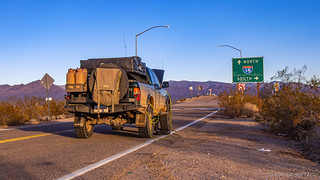
With the sun nearly set, we knew we weren't going to make it too far before needing to find a place to camp, so we aired up the tires for the last time and set out west on I-15. Our destination - just past Baker - was a town named Zzyzx, it's name chosen so as to be "the last word in health." We'd arrive in the dark, but along the way we were treated to such a show in the sky that we couldn't help but to pull over on the side of the highway - passing motorists likely wondering, "What the heck is that guy doing standing on the roof of his truck?" as I snapped photos of the light show above.


We'd start our journey home the following day, but not before checking a couple last sights off of our Mojave Preserve bucket list.
The Whole Story


Hi friends, very entertaining, your trip through the Clark mountains. I am a field trip leader for Searchers, Anaheim. We are planning a trip for 10-05,6-024. It appears from our research that the area we want to collect is just slightly into the MJPreserve which forbids collecting and managed by the Firest Service. Wondering if we should risk driving up the hill from our camp @ Cima road to collect on the dumps and risk the ire of any forest service staff that might happen by. Thanks, Rick Webber
Hi Rick, glad you enjoyed the story. I noticed on your organization field trip page that you're hoping to head to The Copper World Mine. That mine - as well as several others nearby - is well within the park boundary, so any collection there is forbidden (as you know). NPS has stepped up their patrols through the Preserve, especially in the Clark Mountains due to some questionable behavior taking place at the old Colosseum Mine - but even if they hadn't, I'd hope that the Searchers organization would want to follow the rules of our public lands. Hopefully you can find another place to collect - there are many in the Mojave!
Yep, got it my brother.
Peace and Happy Trails 😊