
Hoping for a repeat of the previous morning, I was up early to capture a sunrise that never materialized. With few clouds in the sky - especially above the eastern horizon - there was nothing for the sun to highlight as it made its daily appearance just before 7:00am.


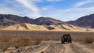
Having gotten a taste of some really nice talc mines the previous day, our final day in the park was going to be a whirlwind of the same. Before lunch, we'd visit two more - The Superior and Whitecap - a little further north in the Ibex Hills, and after lunch we'd head to the southern edge of the Black Mountains where the Pleasanton, Monarch, and Moorehouse mines all exploited the white powdery substance around the once-oasis, Ibex Spring.
It would be a day out of Veruca Salt's (who always wanted everything for herself) Willy Wonka. I could just hear her incessant voice screaming "mines, mines, mines - all mines!" So, without losing a beat, we set off toward the Superior, our anticipation for what we'd find, high.
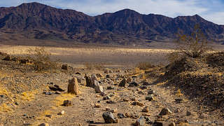
The hike to the Superior Talc Mine was a little less than a mile up a sandy wash - easy peasy in comparison to earlier forays. Consisting of three claims, this mine was owned and operated by the Southern California Minerals Company from its inception in 1940 until recent years. Easily the most developed and productive talc mine in the southern Death Valley region, the Superior Mine produced 141,000 tons of ore between 1940 and 1959, its most active period.
Interestingly, in a 1981 Historic Resource Study, the NPS determined that the general state of the Superior Mine - which remained in intermittent operation through the early 1960s and is now owned by Pfizer, Inc. - was unworthy of any preservation efforts.
The Superior Mine, reflecting its greater period of production, has more extensive structural remains. These are, however, of a more modern period than found elsewhere in the region, and consist of tin and frame living shacks and mine buildings, as well as a steel headframe. In a mining sense, this site is the most important one in the area, but it is also the most unsightly and the least historic. Judging from the condition of the camp, operations in the last years were carried out on a shoestring budget. As a result, the area today resembles a modern garbage dump more than a possible historic site. When the underground talc lodes ran out, the company resorted to stripping operations before giving up, leaving the area pitted with large and small gouges and holes, and destroying the possibility of interpreting the earlier years of activity. This general condition of the site, coupled with the modern flavor of the remaining structures, makes the Superior mine unworthy of any preservation efforts.A History of Mining
Since the resource study, the entire footprint of the Superior Mine has been cleaned up and graded. While no structures or adits remain, we still found the site fascinating - a huge white trench only hinting at the scale of this operation.


Without any structures to explore, we set our sights on a treasure hunt of sorts. Our ever-present companion - Michel Digonnet's Hiking Death Valley - suggested that if we poked around enough, we might discover some rusty old carcasses of Southern California Minerals Company vehicles.
Challenge accepted.


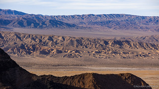
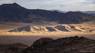
Perhaps predictably, in the course of finding the forgotten carcasses, we discovered the real treasure this place has to offer: the views. Up here at the top of the Ibex Hills, it felt as though we were on top of the world.

From the summit above the Superior Mine, it was a bit more than a mile down the west side of the northern Ibex Hills - all along an old mining road that would have connected to the same road we'd hiked in the opposite direction the previous afternoon - towards the final talc mine of this cluster - the Whitecap.

As we continued to lose elevation - that we'd have to gain on the return trip - we started to question when we'd find what we were looking for - one of the best-preserved headframes in the area. It was only as I consulted the map that I'd saved to my phone that we realized that such a prize no longer sat at the end of this trail. Looking down over the obvious location of the mine, there was no structure to be seen!
Could the Whitecap have been restored similarly to the Superior? We doubted it, given my pre-trip research, but knew that anything was possible as we covered the final approach to the site.


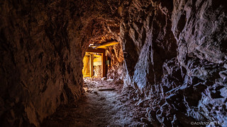
As we were checking out the adits, I looked down on the ground an immediately had a sinking sensation. In a pile of nails, I'd discovered the fate of the headframe.


It was @mrs.turbodb who first spotted the tricycle. She mentioned it as I was taking a photo of the upper pully, and I thought she was making a joke about the large wheel surrounded by beams. Only as I poked around a bit more, looking for various bits of scorched wood that told the story, did I see the actual child-sized mode of transportation sitting a little way from the remains.

With what remained of the Whitecap explored, we retraced the two miles to the Tacoma, continuing to wonder aloud when the burn occurred.
Note: I emailed DEVA NPS upon our return and was told that the headframe burned more than a decade earlier. In fact, some photos from 2013 show that it'd burned prior to the 2016 publication of Hiking Death Valley, Second Edition. Strange that Digonnet didn't update the description!


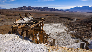
After a short stint on Ibex Spring Road we pulled up to the Pleasanton Mine where our first order of business was to consume the last of our tuna, chips, and an unfortunately-soapy-tasting Honeycrisp apple while enjoying the extensive workings that rose up the hillside behind us.

As with the proliferation of mines that we'd explored over the previous 24 hours, a group of mines also sprinkled the hillsides here at the southern end of the Black Mountains. Many of the claims were located by John Moorehouse in the mid-1930s, though as is commonly the case with mining in Death Valley, the vast majority only produced small amounts of talc.
Eventually, Moorehouse leased his claims - as did other owners in the area - to the Sierra Talc Company. Between 1942 and 1945, his mine - along with the nearby Pleasanton and Monarch Mines - were extensively developed, and by 1959 more than 115,000 tons of ore had been extracted.


This middle level of the mine appeared to be where most of the activity took place - via several adits. Excited, I immediately started climbing up the hillside behind the headframe, while @mrs.turbodb followed a path around the hillside to a series of shafts. This turned out to be slightly inconvenient, since as soon as I got to the top, I realized that she was carrying the lens I wanted to use!


After checking out all the levels of the Pleasanton, it was time to move on to the Monarch mine just a bit further up the road. Accessing the same talc body as the Pleasanton - and after both mines were leased by the Sierra Talc Company - they were connected by a 950-foot tunnel that follows this ore body most of its length!


From the Monarch mine we had only one more mine to explore - that of Moorehouse who'd uncovered this talc-filled region in the 1930s. But first, a quick side trip was in order. Impossible to miss during the entirety of the drive to the Ibex Spring area were a cluster of palm trees rising up out of the desert. These - of course - were clustered around the once-prolific spring that supplied water not only to the miners who lived here, but also to the mines themselves. Today, easily accessible via vehicular traffic, the area around the spring is badly vandalized, and no surface water is present.


After seeing the state of the springs and surrounding area, we spent even less time there than we did at the Monarch Mine. Luckily the bad taste in our mouths wouldn't last long as we made our way to the final mine of the trip. Unsure what to expect - and really, with relatively low expectations - we slowly made our way up the road toward the Moorehouse.
This road - unlike the others - was in rough shape. Years of erosion have taken their toll, resulting in several places that were tight even for a 1st gen Tacoma. Throw in loose rocks and steep grades, and you can understand why I'd highly recommend hiking this 2-mile-long route rather than driving.

The extensive complex of adits, ore bins, ore chutes and tramway networks at the Moorehouse was impressive to say the least. Completely by accident, we'd saved the best for last! In relatively good condition, these structures are massive - extending several hundred feet up the hillside and several hundred feet to each side of the dual ore chutes. As we parked the truck and began our exploration on foot, I'm sure @mrs.turbodb would have told you that I could barely contain my excitement.


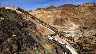

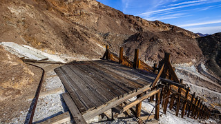
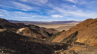
After looking over the main structure and ensuring proper operation of the ore chutes  we headed up the hillside to the additional levels of the site. Mined all the way to the ridgeline, the road often reached grades well over 30%, and with decades of neglect have nearly become dry falls.
At several levels though, the views made the struggle to the top, worth it.


Now just a bit before 3:00pm, we turned to each other and agreed that this had been the perfect way to end a trip that we'd planned to be entirely different. It's funny how that happens sometimes - plans made and then upended, experiences treasured that may otherwise have never been. It's a good reminder that staying flexible and keeping an open mind are one of the most important aspects of exploring a place like this.
As we headed back down the mountain, our conversation turned toward the long drive home. The best option - we agreed - was to shoot for a bit of BLM land outside of Beatty where we could spend the night with reasonable temperatures. Then, at way-too-early-o'clock, we could begin the long slog north - across the frozen high desert of Nevada and Oregon - only to to hit the sack once we got home, 19 hours later.

We left Beatty just before 3:00am, a cool breeze and 33°F temperatures reinforcing our decision to camp at lower elevations even though it meant a long drive home. It was a reminder we'd get more than once as the miles ticked away.


Oh, and through it all, the new transfer case performed perfectly. We'd put lipstick on the pig, and damn, it worked!


On the last mine--i can see how carts on rails moved talc powder-rocks-stone-? But how did the talc go down the hill in chutes? Dry-wet-or like bowling balls? any ideas?
Hi Mark, when the talc was sent down the chutes, it was dry. All of the chutes had enough pitch/grade to them that gravity would pull the talc down to the bottom, where it'd either be collected in a bin (to be loaded in a truck/rail car) or would end up in a pile that they would scoop up again later.
Hope you're enjoying the stories!
Always enjoy each chapter of your adventures. I hope to, someday soon since my days are numbered, get a 4WD and be able to explore some the places you've shown along with some old places we explored 50 years ago with all my desert loving friends (all but one gone now). My 2003 Ram 1500 quad is great but with 2 wheel drive is not up to some of those roads. Funny, about 50 years ago I got my hands on an old Diamond Rio that had been used for desert mining. Fixed it up and had some fun, 2 speed rear end and a bunch of gears including a "granny gear" and your photo of the mining truck with the shift instructions reminded me of that old Diamond Rio.
Hi John,
Great to hear that you're enjoying the adventures. I originally started writing them so my family would know what I was up to, but then found that friends enjoyed them as well. It's always nice to hear when they bring back memories for someone, or help encourage another person to get out for their own adventure (whatever that may be).
I bet that Ram would be pretty great for a lot of what I do, since it sounds like you have some experience driving it (and other vehicles) on adventures. The driver is, I think, more than 50% of the equation much of the time.
I'd love to hear about some of the places you enjoyed exploring back in the day. I always find that recommendations from others, and the memories they have there, can add a lot of enjoyment to a place for me!
Cheers,
Dan
Moorehouse. What a find! I'm going to be enjoying this chapter over and over.
You have taken me places I know I can no longer go. Age has put an end to my climbing and exploring the way you and the Mrs do. I know and respect my limitations. Rats!
I do think another trip to Death Valley needs to be on the calendar at some point soon for me.
Thank you again, Dan!
So.....Where to next?
Grins!
D
Glad you're enjoying the stories David! Always nice to hear when that's the case for anyone. Without fail, it puts a smile on my face.
As for where to next... it's back to Death Valley of course! A bit of excitement when driving, and some of the most amazing hikes I've encountered. You'll get the emails when I post if (of course), but you can read the teaser here if you'd like. ?
After that, well, I'm not sure yet!
Cheers, Dan
Hi Dan,
Thank you for your reply and explanation. I was fine with what you wrote and agree.
There are people who just don't get it regardless...
Moot point. Yep. Sigh!
David
P.S. looking forward to next chapter...grins.