
Growing up in Northern California, I always thought of "the mountains" as The Sierra. I had no idea at the time that there was another range - one that I'd become familiar with in Washington - The Cascades. With their southern end in the Lassen National Forest, they stretch all the way into Canada.
Conveniently - having recently completed the Plumas National Forest Discovery Trail - we found ourselves at the border between the Plumas NF to the south and the Lassen NF to the north. And so, with a couple days to explore, we made the decision to climb into California's Cascades.

Camped on a ridgeline just south of Lassen NF, we awoke to a beautiful sunrise - made richer by a bit of smoke in otherwise blue skies.

Unsure how long the route would take, we were up by 6:00am, ready to get an early start to the day.

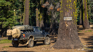
We'd camped in a stand of Sugar Pine, their cones more than 12" long.

After a quick tear-down of camp, we quickly covered the last few miles to a random intersection in the middle of the woods - the edge of the Lassen National Forest.
As with the Plumas NF BDR, the good folks of the USFS have put together a Lassen National Forest BDT trail guide for this 186-mile* trail. With five sections and 25 discovery points, the route can take 2-5 days depending on how much time is spent making forward progress each day.
* Since many of the discovery points are off the main route, the actual length of the trail is closer to 275-300 miles.
Section 1: Sierra Nevada - A Gathering of Forces
250 miles long and 50 miles wide, the Sierra Nevada tilts up along its eastern edge, exposing its history in huge granite boulders. The first section of the trail would wind its way through the northern reaches of this range, as we made our way toward the much younger Cascades.
Dropping down off the ridge that defined a political line between two forests, we found ourselves driving along Yellow Creek. The temperature here was a good 20°F cooler than it'd been at our higher elevation, and we kicked ourselves for not covering the ground the night before - sleep so much easier when you're not sweating buckets through the night.

Yellow Creek - surrounded by trees singed in the Dixie Fire - was cool and refreshing on a windless morning.
We pushed on, into Humbug Valley. Used for ceremonial purposes over thousands of years by the Maidu Indians, the valley acquired its current name from miners in the 1840s when their prospecting didn't result in the buckets of gold that were uncovered elsewhere in the region. The valley was eventually acquired by PG&E - for use as a reservoir to feed a hydroelectric plant - but was never developed, as nearby valleys proved to be better suited to the purpose.
PG&E ownership continued until 2019, when the Maidu Indians were given back the land on and around Yellow Creek in Humbug Valley. They run the Yellow Creek campground where we should have camped. (Thanks to Greg for this additional information.)

Until Dixie, this road sported matching fences along each side. Today, only some charcoal remnants and a lack of grass where the fence once stood are all that remains on the left side.
After the fire, there's not much left to explore in Humbug Valley - both Soda Springs and an old cabin mentioned by the guide, destroyed - so we continued on, the roads allowing for relatively high speeds, towards a spot where the road crossed the Pacific Crest Trail (PCT).
There were four hikers at Cold Springs when we showed up at 8:15am, all of them breaking camp and filling their water bottles for what I can only describe as a torturous trek through the hot, dusty landscape over the course of several months. Rather than disturb them, we pulled a few things out of the truck to gain access to our refrigerator and cold milk, and ate breakfast while we waited for them to set out for the day.

Penstemon (Penstemon gracilentus) covered the hillsides, with plenty of sun streaming through the charred trees.

Some enormous trees - centuries old - still stand, for now.

Cold Springs - a welcome sight for the weary PCT traveler.
A few miles on, we crossed the PCT once again, this time just under the summit of Humbolt Peak. On a cooler day, we'd probably have made the 1.6 mile trek to the top, but with temperatures already climbing, we decided it was better to simply make our way along the PCT - to explore the old wagon road that was constructed from Chico to Honey Lake in 1863.

From just below Humbolt Peak, we got our first glimpse of Mt. Lassen in the distance.
It has to be a little depressing when you've come this far (from Mexico), and the sign reminds you that you've still got more than half the trail to go.

Who needs a pack? This trail is easily done in a morning. 

Not too far along the PCT, the old wagon road has been supporting modern travelers for more than a century and a half - if you know where to look for it.
Trekking back to the Tacoma, my first act upon starting the engine was to flip the A/C to full blast. It may not yet have been 9:30am, but the temps were already reaching 90°F and we were getting sticky. Then, with our little cocoon of cooling air, we pushed onward toward the Colby Mountain Fire Lookout.
We always enjoy lookouts - both for the views, but also for the chats with friendly staffers - but when we arrived at the top of Colby Mountain, we were greeted by a "Sorry, Closed Today" sign stretched across the bottom of the stairway. A couple contract fire fighters - their F650 idling nearby - let us know that this was one of the keepers days off, but that we were welcome to walk as far up the stairs as we could get. Naturally, we obliged.

A bit of a bummer to get to a lookout, only to find it empty. Originally built in 1912, it was replaced with the current structure by the Civilian Conservation Corps (CCC) in 1934.

We see you getting closer, Mt. Lassen.
Section 2: Land of Ishi - Guide of the Yahi Yani Indians
Named for the last survivor of the Yahi Yana Indians, the Ishi Wilderness is a congressionally designated portion of the Lassen NF, set aside to preserve its primitive character and "provide opportunities for solitude." Of course, people have lived here for more than 10,000 years. Most recently, the Yahi Yana Indians called it home for 2,000 years, followed by emigrants in the mid-1800s - rushing west towards the promise of gold in the Sacramento Valley.

Dropping down toward Rush Creek, the foliage thickened.

Light filtering through the Maple understory.
We'd cross several rivers through the Land of Ishi, the first being Rush Creek, which wasn't Rushing but was one of the final places we'd see significant burn areas. From here - to our joy and relief - the forests we'd travel seemed unscared by recent fires, allowing us to enjoy a more pleasant and varied terrain as we made our way north.

Rush Creek - colorful in the morning light!
Not quite yet 11:00am, we were both getting a little hungry and decided that we should start looking for a place to eat lunch. It was hot - again - so shade was a must, with views being desirable-but-not-required. We hoped that McCarthy Point Lookout would fit the bill.
Turns out that we didn't really understand what McCarthy Point Lookout was until we arrived. It is certainly on a point - overlooking a valley - but it is not a fire lookout at all. Rather it is a "room with a view," constructed by the Civilian Conservation Corps (CCC) in 1936. While it was used for observation until the mid-1960s, it is now rentable as a place to stay; otherwise, it is locked to visitors.
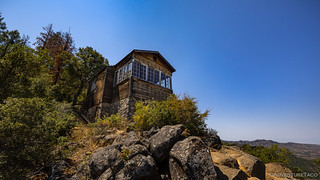
A nice perch, if you can get it.
Instead, we continued on, deeper into the Land of Ishi, towards another promising-sounding spot: The Narrows. Again though, it wasn't what it seemed - a narrow canyon with water and shade - but rather a narrow ridge basking in the sun! Here, we didn't find a place to eat, but we did find a memorial to Ishi and a California Trail marker.

It was neat to see a marker for Ishi, who I learned so much about in school as a kid.
From this narrow ridge, you can see north into Mill Creek Canyon and south over Deer Creek Canyon. In 1848-50, wagons had to negotiate this ridge on a trail barely 30 feet wide. The experience of negotiating this fine line between canyons must have caused stomachs to roil and heads to spin - almost every diary written along this route tells of this spot. In “Recollections and Opinions of an Old Pioneer” (1880), Peter H. Burnett remembers:
“Old Peter Lassen insisted that our wagons should keep on the top of the ridges, and not go down to the water … Our pilots … discovered a strip of ground, about thirty feet wide, between the heads of two immense and impassable ravines, and connecting the ridge we were compelled to leave with another. It was like an isthmus connecting two continents.”

"There is an immense abyss on each side. We could look down thousands of feet, the side of the ridge seeming almost perpendicular." -Charles Glass Gray, Sep. 29, 1849.
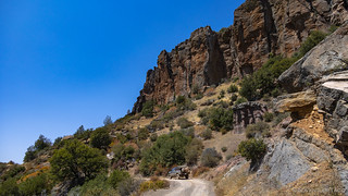
Dropping down off of the ridge - which I will be the first to say was not at all narrow or scary - we rounded a corner with audible gasps escaping both our lips. In front of us, Black Rock rose up out of the valley. The hardened throat of a plug dome volcano, plug of lava is denser than the cone surrounding it, and eventually the cone erodes away entirely.
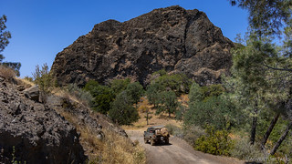
Black Rock was a sight to behold.
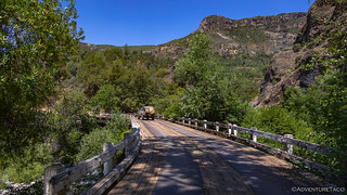
Just beyond Black Rock we crossed Mill Creek on a cool, curved bridge.
Mill Creek looked super inviting for a swim in the now-over-100°F temps, but with poison oak lining both sides of the water, we settled for an unimproved campground with a shady table to indulge in some cool sandwiches and way too many - but just the right amount - of potato chips.
Even in the shade, it was hot. As such, we didn't hang around longer than it took to eat lunch and put two jerry cans full of fuel into our quarter-full tank - hoping it'd be enough to get us to the end of the route - opting instead to climb back into the air conditioned cab for the climb out of the canyon.
Up the other side of Mill Creek Canyon we go!

Travelling the ridges, we caught glimpses - here and there - of Mt. Lassen, getting closer!
Side Trip: Turner Mountain Loop and Lookout
For the next couple dozen miles, we made quick progress along Ponderosa Way (FS Road 28N29). Originally called the “Ponderosa Way and Truck Trail,” it was one segment of a 700-mile fuel break built by the Civilian Conservation Corps in the 1930s to limit the spread of catastrophic wildfire across the Cascade and Sierra Nevada ranges. For us, it was a veritable highway leading to the town of Mineral, the end of the stage, and the jumping off point of a side trip to the Turner Mountain Lookout.

To reach Turner Mountain Lookout, we circumnavigated the base of the mountain, driving through blazingly green forests.
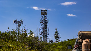
Now that's a tall tower! Sure doesn't look very big though!
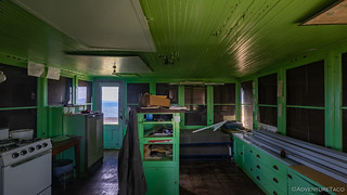
And now we know why the lookout tower is so small - the living quarters of this lookout are located nearby.
Appears that this lookout hasn't been used for some time, but is still in relatively good condition.

Brokeoff Mountain and Mt. Lassen were easily visible from the cabin. Perhaps the tower wasn't necessary at all.
Naturally, I wasn't about to pass up the opportunity to climb the 102 stairs to the top of the tower, and - to my surprise - I was able to convince @mrs.turbodb to come as well! (Note: I'm not sure she was happy about that decision once we got about halfway up, and she certainly wasn't happy for the first half of the way down. ) The views from the top - as you'd imagine - were spectacular.

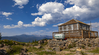
To the right, our home away from home.

To the left, the primary use of Turner Mountain today.

And straight ahead, Mt. Lassen.

Someone was happy to be back nearer the ground.
Back on firm footing, it was a little after 5:00pm when we arrived - once again - in Mineral. Decades ago - when this route was created - there was fuel here, and the station still sports a price board listing regular grade gas at $1.799. Obviously that was some time ago, and since the Lassen NF BDT doesn't pass through any other towns, it is now a requirement to carry extra fuel onboard - 17 gallons for us - to complete the trail without driving 60 miles into Chico or Chester.
Luckily, having siphoned 11 gallons in at lunch time, and with an additional 6 gallons in reserve, it was looking like we'd have enough to make it the rest of the way - assuming we didn't run into some sort of trouble.
For now, having chosen not to camp at Turner Mountain Lookout since it was still quite hot and the sun wouldn't let up for another four hours, we had a decision to make - continue on to the third leg of the route, or look for somewhere nearby to camp.
Ultimately, I'm not sure we made the right decision. At the same time, I'm not sure we could have done anything differently...

So back a few years ago the Maidu Indians were given back the land on and around Yellow Creek in Humbug Valley that was originally theirs. They run the Yellow Creek campground that you may have seen. No more PG&E.
At one time back in history yellow Creek held trophy trout.
That's very interesting/cool - we had no idea! Thanks for the clarification, Greg. We did stop a bit as we went through Humbug valley, and though I didn't include the photos in the story, there was a nice carved stone near Soda Springs with a Maidu blessing on it. That certainly makes a lot of sense, now.
I've updated the story with your additional information, thanks again.
That tall lookout tower looked like it was in the fire, is it really smoky black? I'm not sure (personally) I make it up to the top although I've climbed communications towers for many years due to my work (MW radio). Overseas (Army) I would go up the more than 200' tower on a regular basis if a beacon needed to be replace or there was a cable problem. Usually take lunch up with me since it took a while to climb up and down. Had a great view but if the wind came up it was scary and time to clip my safety belt in. Now I limit myself to a 17' ladder and only when I need to inspect my home's roof! LOL
The tall lookout was not in a fire, it was just aged from weather and lack of maintenance; that "smokey black" is just unpainted plywood - or significantly in need of paint plywood - hahaha! You may have noticed the lookout "quarters" in the (much lower) cabin below - I think that the cabin is actually the lookout now, if the mountain is ever staffed. It doesn't have quite the 360 degree view, but it still has a good command of the surrounding area.
The tall tower - with several of the stairs missing - is there for historical purposes. The room at the top was only 8'x8' or so, including the hatch to enter from the stairs - tiny!
Stay safe out there; even a 12' ladder can cause some big troubles. Ask me how I know ?. Of course, I'm still young(ish) and dumb, so if it looks sketchy-safe, I'm all for going up, LOL!
I may not have seen all of your stories but I have read every one since I started following you about nine months ago. While you make reference to your wife fairly frequently (usually in regards to making meals and napping while underway), you usually show her only in photos taken far away or with her back turned. (I presume this is to preserve her anonymity.) This was the first installment in which you included a number of shots which clearly showed her face. I am curious as to why the change in policy. Also, I don't believe I have ever seen a photo of you. Finally, as you know from my previous comments, I am also a photographer and I have enjoyed some of the "shop talk" we have shared. I was somewhat started to see that you had placed one of your lenses on the ground, in order to illustrate the size of the pine cones. I am pretty sure I would never do that to one of mine -- not without putting down some sort of clean cloth first. As I have indicated before, I am thrilled with your photographs and I believe they add an indispensable dimension to your stories. Thanks, as always, for sharing.
Well, this put a big grin on my face as I read it; I appreciate the kind words. Seriously, thank you! There are several points you touched on, I'll try my best to answer them all. If I miss any, or if anything else pops into your mind as you read my answers, feel free to ask more!
My wife. I'm going to break this down into a couple points that I think are worth addressing.
Me. I rarely have photos of myself because I'm mostly behind the lens. I do try to get at least a photo or two of myself using the tripod on a trip, but only some of those make it into the story. The most likely situations for this would be a sunrise scene (from Redhead Down #9), perhaps peering into a mine shaft, or - during the winter months - climbing a dry fall in Death Valley (really, in search of Grand Views). There are also a few of me as a whipper-snapper in the post I wrote about How I Got Started with Offroad Adventuring.
Bonus - here's a shot (admittedly old) of the whole family, from an adventure we took to Canada, way before we started to get serious about adventures. The small one is much less small now. ? Family trips in general - with the kiddo - tend to have more photos of all of us, because you know, family. (The curious can find most of our family trips, here.)
Camera Lens. I have to admit that I've never really thought about not setting my gear on the ground. I'm careful to ensure that caps are always on when I do it - at least on the "end" that connects to the body - but the guys I "learned from" on my very first trip (see The De-Tour) are much less careful with their gear than I am. Looking at it now, I'm glad for that, because it allows me to not worry that the gear I paid so much for is getting dusty or dirty; to me, that's just part of what comes along with using it in the types of situations I find myself in. Secondly, even the interior of the Tacoma gets super dusty on these trips, so I imagine that it's no more hospitable in there than it is on the ground. And lastly, I've done much worse to my gear. #DisasterouslySadDay. Of course, that meant I could get even better toys.
At any rate, I figure that all my camera equipment should really go in for a good cleaning... the problem of course, is that would mean postponing a trip so I could wait for the back-and-forth in the mail. Perhaps there will come a time where I think that's worthwhile. Or maybe it just means I should have a second body to tide me over! (LOL, I wish!)
Hope that answers your questions for now, I had a great time thinking about them all as I wrote up this - probably too long - reply!