
The night was chilly, but by using some Little Hotties inside our socks while we slept, we were able to stay nice and toasty in the tent. Still in the shade since we'd parked reasonably close to the hillside to shelter us from the wind, we walked out into the desert to enjoy our breakfast and soak in the long rays of the sun as it peaked over the southeastern horizon. By the time we were done, the sun was just starting to hit the tent, and as @mrs.turbodb got the kitchen put away, I stowed the tent for our days activities.
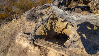
Retracing a few of our steps from our first Mojave Road trip, one of the things I wanted to see was something we'd completely missed in the dense fog the last time we were here - the collection of frogs (and other figures) near the Mojave Mailbox. Heading west from our camp spot, the first thing we came on was the turn-off to Marl Springs. I had thought we'd found the springs last time, but it turns out I'd simply found some other ruin along the Mojave Road, so it was nice to discover the mouth to an old mine shaft, the spring itself, and an old arrastra this time around.
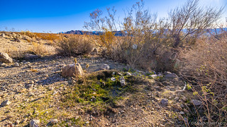

From Marl Springs, it isn't much further to the Mojave Mailbox, and our only stop along the way was along the top of a low ridge where we'd transitioned from sun to pea-soup fog the previous year.
And with that, we reached the mailbox - looking as snazzy as ever out in the middle of the desert. As always, we took a look through the various trinkets and left a note for future travelers.


But that's not why we were here - we were here to see the collections of figures that have taken up residence behind the mailbox over the last several decades. There are several groups, the most famous of which are a group of frogs - but we explored them all, the trucks and gnomes also bringing smiles to our face :).


As it turns out, these collections are being removed by the National Park Service (NPS) in February 2020, and a sign at the location states as much. I'd heard about this from various internet rumblings prior to our visit, and initially felt like it was a bit of a bummer. In my mind the collections weren't really doing any harm, though of course I understood that they aren't natural and so don't technically belong. I also thought that it'd probably only be a matter of time until people started other, new collections!
I've since discussed with more reliable sources, and it sounds like there are some good reasons for the removal - and that even in the removal, all is not lost. In fact, the NPS is going to transfer the figurine collections to the Mojave Desert Heritage and Cultural Association Museum in Geoffs, where they will create a replica of this section of road, complete with the frogs, trucks, and gnomes! So, that's pretty cool. 
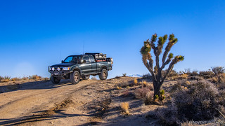
From the mailbox, we could clearly see that another place on our agenda was snow-free, and so without further ado we continued down the Old Mojave Road until we hit the pavement that is Kelbaker Road. From there, it was just a quick jaunt north to our turn off on the Aiken Mine Road towards the Cinder Cones.


We had three stops planned here, but our first stop along this route was not for a cinder cone at all - rather, it was for a lava tube that's been made accessible for exploration with the installation of a metal ladder that ushers curious hikers down into the depths of the earth.

The lava tube itself is formed when molten lava flows down a slope and its exterior cools enough to solidify. Inside this crust, the lava is still molten and flows through its own self-made pipe. In situations where the lava all drains out of the tube - and the tube isn't filled by a future flow - a hollow lava tube remains for future explorers to discover. In the case of this tube, two skylights (cave-ins) exist in addition to the main access - also a cave-in - making for some dramatic photos when the lighting is right.

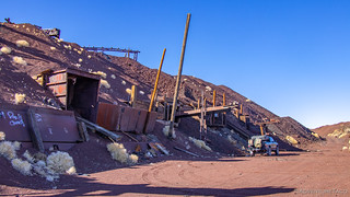
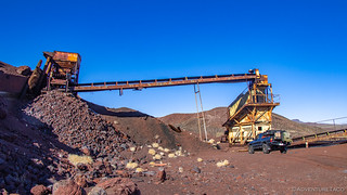
The tube itself isn't long - perhaps only a couple hundred feet - so we were soon off to our next volcanic destination - the Aiken Cinder Mine. One of several cinder mines in the 60-square mile region, it's one of the best preserved, having been abandoned in 1990 when it was no longer financially solvent. Prior to that, it'd been in operation for nearly 40 years, hauling out on the order of 1.28 million tons - the volume of a tall building - of cinder, used for construction in Las Vegas and southern California. Much of the mines machinery still stands dormant now 30 years later, as do 8 million tons of additional cinder that have been stockpiled around the property, waiting for the day that the price of the material might rise high enough to make its sale profitable. (from Hiking the Mojave Desert: The Natural and Cultural Heritage of Mojave National Preserve)


Having experienced some of the human interaction with the cinder cones, we decided next that hiking to the top of one would be a fun activity. We choose the youngest cone to hike, for no real reason except that it was the first one we came upon when approaching from the southwest! This cone, like nearly all the others, had an old road that traversed its sides, making the climb up much easier than if we'd had to navigate the cinder scree pile directly.

As we made our way up, we didn't really have any idea what to expect - but as we rounded the cone and could see the western flank, it became clear that there was more than met the eye from ground level. For nearly a mile to the west, a lava flow that occurred from the base of the cone stretched out into the distance. Only some 10,000 years old, few plants have established themselves on the flow, making for a dramatic contrast with the surrounding valley.


The hike itself was reasonably easy. At a little under a mile and ~400' of elevation gain we completed it in under an hour - including the time we were rock hunting and taking photos and joyously leaning into the 30+ mph winds at the top of the cone. And the views were great. We even spotted a group of Jeeps out exploring the preserve as we were on our way down.


We'd eaten lunch out of the back of the truck prior to our little jaunt up the cinder cone, so upon our return we were able immediately escape our windy surroundings and start off towards our next destination. It was at this point - as I recall - that the idea of exploring the route I'd initially planned, but doing it in exactly the opposite order than I'd planned it, was floated. That meant we'd head south, towards the town of Kelso, to explore a few highlights in that area.
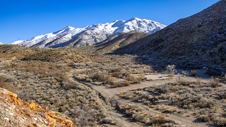
With the Providence Mountains rising tall and snow-covered in front of us, neither of us had any complaints as we drove the Kelbaker road towards Kelso.

In fact, it turned out to be a race - as in the distance, we could see a long dark line - the 1:27pm Untion Pacific Los Angeles Limited - heading towards Kelso Station.

I hoped to get there in time to photograph it coming through, but unfortunately we arrived just as the engines were passing through the crossing. By the time I jumped out of the truck it was too late to get anything but some freight cars making their way through, not to mention the fact that I was at completely the wrong angle! Win some - lose some!
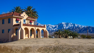
Still, Kelso Station, which has been restored and is now the main NPS visitor center for the Mojave National Preserve didn't disappoint, its stucco walls gleaming bright under the early afternoon sun. The inside has been turned into a museum, and we spent a few minutes reading up on history of the area, and admiring the various stuffed wildlife that we might stumble on in the preserve.
Oh, and I asked a park ranger there if he knew whether there was snow at a few other places in the park, since I thought that might be something they were keeping tabs on, given the rarity of the white stuff here. Turns out nope - he was completely oblivious to the fact that there was snow anywhere or that it might be of any interest to visitors. "There's no snow here, I don't know about anywhere else." he said. 

From the station, our plan had been to go strait to the Kelso dunes, but as we made our way further south, @mrs.turbodb took a look at the map I'd printed out and remarked, "Hey, you know the Vulcan Mine is nearby, and might be at a low enough elevation that there won't be snow, right?"
It turns out I didn't recall that, but I was happy nonetheless, so a few miles later we turned east and headed up into the foothills of the Providence Mountains. The snow level was still right around 3500', and we hoped that the south-facing nature of the Vulcan Mine would mean that we'd be able to explore it even though we'd be reaching elevations as high as 4100'.

As we continued up into the mountains, the road remained clear of snow and the Kelso Dunes rose up out of the valley floor in our mirrors. Before long, we'd arrived at the first of two access roads to the mine - this one allowing us to check out an old foundation that more recent visitors have started converting into a picnic/grilling area. 


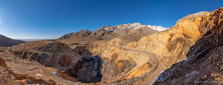
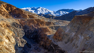
The real reason for the trip to the Vulcan Mine - naturally - was to see the large pit that was excavated primarily between 1942 and 1947 by Henry Kaiser. He was the same man who would go on to start Kaisier Permanente Health Care, but at the time he was building ships for the US Navy to assist in fighting WWII. In 5 years of production, his company pulled 2.64 million tons of iron ore out of the area - double the production of all other California iron mines combined! So, we continued to the second access road and then headed out on foot to explore the pit and the kaleidoscope of colors still strewn around on the ground.

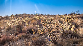
Also plentiful were cholla cactus - their arms extended and glowing as they were backlit by the sun. We'd see these for our entire trip, and it's always hard to capture their sun-lit beauty - but I think this photo does a reasonable job of just that.
Now, it turns out that my original plan had been to access the Vulcan mine from the eastern side of the Providence Mountains via a natural gas line road, and even though we knew that today we'd be headed back west towards the Kelso Dunes, we decided we'd check out the road to the east, just to see if it would have been passable. We first passed by the foundations of the old Vulcan Mine town site, and then reasonably quickly climbed a couple hundred feet in elevation as the snow increased dramatically.

We soon came to the spot where everyone before us had turned around - the slippery incline and gravity too great to overcome. The snow was still only about 6 inches deep, so I figured we might as well give it a shot ourselves. The first attempt got us within 100 feet of the summit, and the second within about 30 feet. Surely a third attempt would allow us victory - but we decided that there was no real reason to tear up the road any more than we already had - after all, we'd be heading out the opposite direction anyway.

So, I backed down to a turn around and we set off for our final destination of the day - the Kelso Dunes.

It was 3:45pm when we arrived at the dunes, only 45 minutes until sunset - and we had a decision to make: should we try for a quick hike up the dunes, or should we just soak them in from below? Well, even though we presented it to ourselves as a decision, it never really was one - we were going to go for it! So, the question then became: are we going for the top, or do we just want to get into the dune field? The answer to this was less clear if you were @mrs.turbodb.  At any rate, we set off at a good pace, still undecided... stopping here and there for a few seconds to really soak in our surroundings.
Upon reflection, perhaps it wasn't really "soaking."


The higher we got, the more the wind picked up - the sand whipping at our legs, both of us glad for the log pants we were wearing. Soon, we had a decision to make - push on to the last ridge, or call it a day and start back towards the truck? Unable to agree, we were able to agree that I could make a run for it. So, I found a place where I could get up into the last rays of sun and @mrs.turbodb snapped a few shots as I conquered the backbone of the Kelso Dunes.

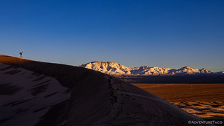
Now, with limited light, we booked it back down, along with just about everyone else who was out on the dunes for sunset. About a total elevation only 600 feet higher than we'd started, the Kelso Dunes aren't as dramatic as the Eureka Dunes in Death Valley, but they are a worthy trek nonetheless - one made even more worthwhile if you can experience the booming of the dunes, a phenomenon that has been observed at only about 30 dunes around the world.
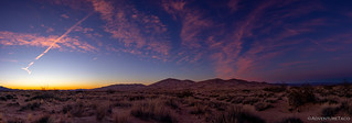
Just as we reached the bottom of the dune field, the sun set over the Granite and Old Dad Mountains to our southwest, the warm orange light giving way to a pinkish purple hue behind the Providence Mountains to our east. Here, we really did spend a few additional minutes to soak it all in.


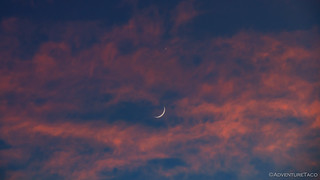
Ultimately we made it to the truck and then just a short distance to our camp site for the night at the base of the dunes. As we got setup, the sky - above the dunes and above the Granite Mountains - put on its own show, full of dramatic colors combined with a moon-star combo that couldn't be beat.

A full day of exploring behind us, we bundled ourselves up for a couple hours in the truck prior to climbing into the tent. There, our conversation focused on our plan for the following day. Our conversation with the ranger at Kelso Station left us wondering - would we once again be stopped in our tracks by snow, or would we have another great day in the preserve as we'd had today?
Only time would tell, but that's part of the fun, isn't it?
The Whole Story


")

")


")

")
")


")
")
")

")


Really enjoyed this episode. Great pictures.
Thanks Philippe! Another installment coming tomorrow morning I hope :). By all means, if you aren't already, you can sign up here for an email when I post it: Don't Miss the next Adventure