
Camped in a casino parking lot, it was a noisy night - at least comparatively. But, by the time we woke up the rain had stopped, a light breeze was blowing, and the skies to the west - where we were headed - were mostly sunny!

The tent still needed a little drying, so I set about that task as @mrs.turbodb got breakfast ready to go. We ate while admiring the long line of cars still backed up on I-15, and then turned on the heater as we slotted ourselves into the line of traffic. Luckily, we only had a few miles to go before our exit - at the Ivanpah Power Station - which would lead us to the Colosseum Mine.
The Ivanpah Power Station it turns out is almost worth the trip alone. It's an amazing set of structures, literally lighting up the landscape. So dramatic was our first view - and I'm sure the snow-covered mountains in the background helped - that we pulled over on the side of the highway to snap a photo.

It turns out we needn't have pulled out of traffic - our designated route was going to take us through the heart of the plant, not that we minded!
Built between 2010-2014, the Ivanpah Power Station is a solar thermal power plant that uses nearly 175,000 mirrors to focus sunlight on three boiler towers to generate steam and power special turbines that generate electricity. Capable of producing 392 megawatts, it was built on public land as a joint project between California and the U.S. Government - at a cost of $2.2 billion. Ironically, despite being a solar thermal plant, it burns natural gas for several hours each morning to warm up the boiler towers, emitting nearly twice the pollution that California allows for power plants and factories.wikipedia
As we drove through the plant, we stopped several times to capture the towers, each one seemingly reaching toward their "mother sun," trying to please her with their brightness.


Now, as I previously mentioned, our first destination was the Colosseum Mine - high in the Clark Mountains - where we'd have lunch before dropping down the other side into Alaska Hills. However, as we neared the mountains, we were pretty sure that those plans were about to change.

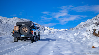
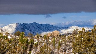
We hadn't hit any snow at 2500 ft, but by the time we hit 3000 ft, the white stuff was everywhere. It wasn't all that deep - and it was definitely beautiful - so we continued on.
The higher we went, the deeper the snow got. By 4000 ft, it was a good 8-inches deep; at 4500 ft, it was 10-inches - just deep enough that the rear diff was starting to drag a bit here and there. We still had another 1000 ft of elevation to go, and we could see that the road got steeper a head. Reluctantly, we made the call to abort our visit to the Colosseum Mine and Alaska Hills - because even if we'd made it, everything we'd planned to see was clearly under a foot or more of snow!
It was time to re-think our plan. We took a look at the route we'd planned - it was a clockwise loop starting from the northeast and working our way south, then west, until we finally reached Zzyzx in the northwest. That clearly wasn't going to work - with many of the initial locations in the 5000 ft range as far as elevation was concerned.

So instead, we headed west - towards some of the lower elevations - hoping that we'd find something salvageable. Otherwise, would we just head home and try again another time?! 
And - as we headed west on I-15 toward Shadow Valley - we noticed that Cima Dome seemed a little less snow-covered than we expected. Perhaps, just perhaps, we could start there - hiking to the top to get a view of the Mojave around us. So, with the Clark Mountains rising white behind us, we turned south and started down Cima Road.
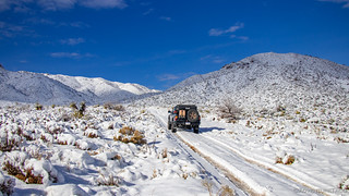
Now, I will say that one of the nice things about all the snow is that it made the roads feel soft and fluffy even without airing down. As we arrived at our turn-off to hike Cima Dome, we saw a Jeep parked at the turn-off taking photos of the snow-covered side road. They were clearly sticking to the main drag in conditions like this. With a big smile on both our faces, we didn't even slow down - we just turned down the road and pressed the skinny pedal - it was hilarious!
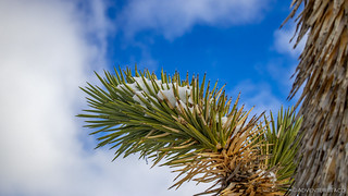
We had several miles to go before the trailhead, and let me tell you - it was surreal. It's not often that you see the desert - Joshua Trees and all - covered in snow.

It was lunch time when we arrived at the corral that designated the end of the road, and the trailhead. This corral was put in place to protect a spring there - though with the gate left open, I don't think it was doing much in the way of protecting. I did a little exploring while @mrs.turbodb whipped up some quick PB&Js for us.

Our bellies happier, we set off. Cima Dome is an extremely symmetric dome that rises from 2100 ft to near 5000 ft over the course of a couple miles. As such, the hike is usually quite easy, as the incline is so gradual. But today was different. With six inches of snow on the ground, the 6-mile loop was a lot of work. So much in fact that we cut it short, turning it into a 4-mile out-and-back.
But, I'm getting a little ahead of myself.

The top of Cima Dome was a little anti-climactic if I do say so myself. Its symmetry is intriguing, but is on such a large scale that - in real life - it's essentially flat. As such, it's hard to really get a good view any direction, and is therefore nice if you're looking for an easy hike in a Joshua Tree forest, but otherwise I think it's something that can be skipped if you're short on time.

Soon enough, we were back down the mountain, and wondering where we'd go next. At 3:15pm it was getting late - relative to sunset at 4:30pm anyway - and so we decided that we'd head further west. That would take us down to more reasonable elevations - and camp along the Mojave Road, at the base of the Marl Mountains.

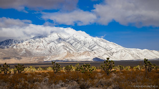
Along the way, the views were spectacular. I'm not sure they were once-in-a-lifetime, since it seems that the desert gets snow on a fairly regular basis - but they were rare for sure!


Eventually of course, we reached the more common views of the preserve, the Dr. Seussian Joshua Trees dotting the land, the ground immediately around us dry. Of course, in the distance, it was clear that these were not normal times.

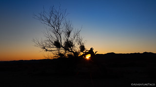
We pulled into our home for the evening just as the sun was setting - it was 4:29 pm. This is quite clearly the biggest problem with winter exploration - with less than 10 hours of daylight, the time to see everything is so short!
Still, how can you not enjoy cool crisp sunsets in the middle of a vast wilderness, the sliver of a moon in the distance!


The sun down past the horizon, our light was now limited. We set about our usual evening tasks - I set up the tent, @mrs.turbodb set up the kitchen. It was tacos and guacamole for dinner - one of our favorites, and we enjoyed them in the waning evening light, the purples of twilight enveloping us in camp.

But with the sun down, it also got cold, fast. After dinner, we found ourselves back in the truck, bundled up in our puffy coats just to keep warm. I mean sure, we could have climbed into the tent, but it was only 5:20pm!  Instead, we read for a few hours - something that would become a tradition on this trip - before brushing our teeth and calling it a night.
We also decided that we'd see if we could salvage one more day in the preserve at some of the lower elevation destinations we had planned. If they turned out anything like this day, we knew we'd have a hard decision to make - because neither one of us really wanted to go home...
The Whole Story


")

")


")

")
")


")
")
")

")


Id like to retrace your route on some of your adventures in the Mojave Preserve. Do you have a .gpx for these adventures?
Thank you
Robin
Hi Robin, I don't share GPS tracks anymore, after having some end up places that'd I'd have preferred they did not. However, if you read through a trip report and follow along with a map, you can generally do a very reasonable job of rebuilding the route. Along with my route planning series of posts, that should definitely get you where you need to go in the Preserve for a trip like this!
I'm always happy to discuss very specific questions if you have them as well, I'm just not giving the entire thing out anymore to "random" folks on the internet! Hope you understand.