
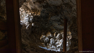
Our spirits still high having hiked Funeral Slot Canyon and from our encounter with the F-16 as we climbed past Father Crowley Point, we turned off onto Saline Valley Road, just a little after 3:45pm. It was 45 minutes before sunset, and with quite a few miles to go before we reached the area we wanted to camp, which - to this point - I'd only narrowed down to somewhere on Hunter Mountain.

While airing down, I saw a spec in the distance. A bird, I thought initially, turning to tend to the next tire. But something in my brain urged me to take a second look. It couldn't be a plane at this time of day, could it? - it was too close to sunset, surely. But boy, that spec wasn't moving like any bird I'd seen; I grabbed the camera just in case. As the solo F-18 roared overhead a few seconds later, an involuntary smile spread across both our faces - the experience always a novel one for those of us who don't live near a base.

Saline Valley Road was as corrugated as ever, but with the tires aired down and ADS suspension, we made good time - soon finding ourselves in the Joshua Trees of Lee Flat, their Seussian shapes, like aliens on the landscape.

We wound our way through the flat toward South Pass, Hunter Mountain growing larger in front of us with every passing moment.

Except for a looking at each other an noting that we were in new territory for the both of us, we didn't even pause as we transitioned off of Saline Valley Road and onto Hunter Mountain. this is an intersection that I've driven through perhaps half a dozen times - or more - in the last several years, at first not knowing where this road led, then unable to travel it due to conditions. I was probably a bit more excited than I should have been, but you'd never have known it from our nonchalant attitudes!
It didn't take long for us to gain enough elevation that snow started to appear not only along the side of the road where it was shaded by Pinion Pines all day, but also along the road itself! Nothing deep or hard to traverse, but a reminder that the road might not be passable for that much longer - not until spring at least.

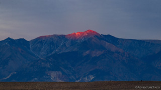
We wound our way up, cresting the top at 7,100', the air significantly cooler than it'd been when we started our hike some 100' below sea level, earlier in the day. And, with the sun now below the horizon, we got a bit of a show, as the whispy clouds picked up the last of the light.

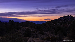
It was nearly dark as we pulled turned onto the road leading to Hunter Cabin, our fingers crossed that we'd find it vacant, with a flat area to setup camp. We were in luck, and within just a few minutes we were all setup and dinner preparations were under way.
It was chilly, and after a tasty meal - chicken salad with avocado, bell pepper, and tomato - it didn't take much convincing to get us out of the cold and into the tent. Already - though it was only 6:00pm or so - we could see the moisture from our breath as we exhaled, and I hoped that the little bit of shelter we had from the pines would be enough to keep any ice from forming on the outside of the tent, since we'd likely be out of camp before it had a chance to melt.
With plenty of time to sleep, we'd gotten nearly a full night's rest when we heard another vehicle coming down the road around midnight. They must have noticed us as well, finding a spot nearby - but out of view - to set up for the remainder of the night. We'd end up chatting with them for a few minutes the next morning when they came over to check out the cabin - a nice couple of guys in a 4Runner, out enjoying the remote reaches of the park... same as us.

Built in the 1860s by William Hunter, the cabin served as a home base where he raised pack mules used to haul material for nearby mines - including Cerro Gordo - and making a considerable profit in the process. The cabin was abandoned by the early 1900s, though it was used sporadically for ranching as late as the 1950s.
We'd arisen early again, and as the sun broke the horizon, we were already cleaning up after breakfast and stowing the tent for the day - one I'd been anticipating for some time: my first exploration of Hidden Valley. We rolled out of camp and along the ridge leading northwest well before 8:00am.
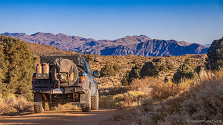
The entire way, the views were tremendous. To our west, the Sierra Nevada Mountains just peaked over the top of the Inyos. To our south, range after range shown blue in the distance.

Well hello, Sierras - I see you peaking out there.

Panamint Valley in the morning sun.
Eventually, we got our first glimpse of the valleys north of Hunter Mountain - not Hidden Valley yet, but Ulida Flat. Separated from Hidden Valley by a small set of hills, as we dropped down off the mountain and onto the flats, a relatively dense grove of Joshua Trees covered this section of our route - one that I can only assume is seen by significantly fewer than some stands in other areas of the park.


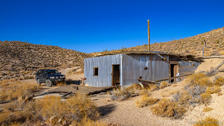
I'd marked a few places that I'd found to explore prior to setting out, but given that the entirety of my research had been done from the comfort of my desk at home, I wasn't sure whether the roads - which looked passable on satellite, but you really never know - would be in good enough condition for us to traverse. Luckily, things looked promising as we turned into the Cottonwood Mountains for our first side trip - the Ubehebe Talc Mine.
Cresting the ridge - the mine just on the eastern side - we got our first glimpse at the old cabin used by miners who worked this area, for some 40 years - starting in the mid-1940s.
Production through the mid-1950s totaled several hundred tons, with shafts sunk into the mountain along the 500' talc zone. In the mid-1970s, the mine's present owner - Cyprus Industrial Minerals Company - acquired the property with the intention to continue development. However, mining operations have been hampered by the site's inaccessibility and by the narrowness of the access road, which the National Park Service would not allow the company to widen. (Go NPS!  )
)
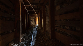
The site itself was actually quite interesting to explore. With lots of narrow gauge rail still installed and snaking between the shafts and ore chute, it was intriguing to think about how things were moved around up here some 50 years ago.
Some serious engineering went into this site.
Secondary shaft with dual access. Follow the talc, wherever it goes!

This enormous ore chute had dual loading doors.
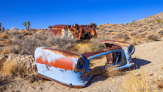
As we explored the mine above the cabin, we noticed an old automobile carcass down in the valley. We could have easily just passed it by, having already explored around the cabin, but what fun would that be? A quick detour as we headed back toward Ulida Flat and Hidden Valley was well worth it to check out this baby-blue-beauty.
Back on the main road, we climbed the small rise south of Hidden Valley just after 9:30am. It was an exciting moment, though perhaps a bit anticlimactic given the rather pedestrian nature of the view - at least compared to other more colorful valleys and ranges in the park - as we continued down to the valley floor.

Comparatively pedestrian, but still a sight to behold.
Situated between the Cottonwood and Dutton Mountains, Hidden Valley is significantly less flashy than its sibling to the west, The Racetrack. With no meaningful dry playa, grandstand, or sailing stones, it's no wonder that Hidden Valley sees orders of magnitude fewer visitors than its neighbor. To us, this was a good thing, as we had the whole place to ourselves, free to explore at our leisure.

I'd considered - and even mapped - a hike up into one of the canyons in the Cottonwood Mountains, but in the end we left that for a future trip, as it was apparent to us both that there was plenty to keep us occupied in Hidden Valley for much longer than the single morning we'd allocated on this trip.

Dry, this was a fun, silty road. Wet, it would be treacherous.

I spy with my little eye, a fault. Or the backbone of a mountain.
One place that we did decide was worth an extended exploration was one of the more popular attractions in the area - The Lost Burro Mine. As we pulled off the main road and up to the Lost Burro camp, @mrs.turbodb read a bit from Hiking Death Valley to give us a sense of the history of this place.


Gold was originally discovered in April 1907 when Bert Shively, fortuitously stumbled upon it while rounding up his burros. For the next few years, the property was worked alternately by Shively and lessees, the workings exploiting a vein up to 10 feet thick and valued at $15 to $18 per ton, as well as a smaller pocket that produced samples worth as much as $1,000 per ton. Within two years, $30,000 worth of ore had been stockpiled at the mine.
In 1915, the Montana-Tonopah Company bonded the property with ambitious plans. To cut down on transportation costs, the company began constructing a 50-ton, five-stamp mill, expected to recover up to 85% of the gold. However, for unknown reasons, it's unclear whether the mill was ever completed, and activity at the mine stopped around 1917.
It was during the 1930s that Andy McCormick, who had been associated with the Lost Burro since its early days, worked here with a partner and recovered $85,000 in gold. After changing hands again in the 1940s, the mine was worked sporadically until the 1970s, and all told, the Lost Burro Mine produced close to $100,000 of gold - one of the richest in the Ubehebe Mining District. Hiking Death Valley
Reasonably well preserved for a reasonably accessible mine, after checking out the small cabin at the bottom of the camp, we peeked into the dugout before heading up the wash to check out the remains of the mill, still standing guard after all these years.


As well, we ventured further up-canyon to several of the mine shafts and tailings piles that littered Lost Burro Wash. Barrels, still full of ore lined the pathways, mine shafts in various states of disrepair peppered the hillsides.

Eventually we made our way back down to the Tacoma, talk of the various relics we'd seen, and when we could come back to explore Hidden Valley in more detail, the focus of our conversation.

At that point, I think we both thought that we'd be heading north out of Hidden Valley and then west towards Teakettle Junction and The Racetrack. But, as often happens, we were distracted by something along the way, and soon we were headed up the a side canyon in Lost Burro Gap to check out the narrows and dry falls.
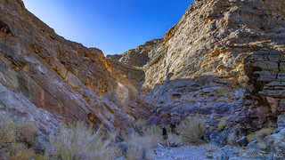

I don't know if it was lucky or not, but only the first dry fall was climbable, and we reached the second - a 25-foot tall, impassable wall - only a quarter mile or so up the canyon. That meant that we lost almost no time with our little detour, and still got to see some seriously cool geology!
And from there, we continued back on our planned route, pulling up to Teakettle Junction just as three other vehicles were leaving; we were definitely back in the "well-travelled" portion of the park!

A few minutes looking at tea kettles - the entire collection of which were less than three weeks old (!) - and it was time to head south towards an icon of the park: The Racetrack.

We'd been to The Racetrack once before - on our very first visit to Death Valley, but it's a bit out of the way and we'd never been back since. We both really enjoyed our walk out to The Grandstand the last time we'd been here, and so pulled over to give it a go again this time around.

It was a nice stroll, and The Grandstand is most certainly an interesting island in the middle of a geometrically fractured landscape, but it was interesting to experience for a second time. There were two aspects of the experience that I found surprising. First - the degree to which - what must be a huge amount of - foot traffic between the parking area to The Grandstand flattens the parched playa. Get off the main line a few hundred feet, and the cracking and shrinking of the top layer of mud is much more pronounced - something I hadn't noticed on our first trip a few years earlier. Second, as cool as The Racetrack is, I find the Alvord Playa much more alluring. I don't know why that is exactly - perhaps the surroundings, or maybe the history with Jessi Combs, or maybe just the fact that it's even more remote than Death Valley - but I found myself "ready to go" much sooner than I thought I'd be, the draw of this popular place in the park no longer as strong as it once was.
And so, before long, we found ourselves eating lunch at the top of Lippincott Pass, its imposing sign standing guard above the grade.

Lippincott has quite the reputation amongst Death Valley fans. Perhaps due to the sign, or maybe because of the way the road is cut into the mountain, there are tales of woe about traversing this route. Personally, I've never found it all that interesting from a road perspective - even when it hasn't been graded for a while, and portions are washed out, it has always seemed reasonably tame to me.
I mentioned to @mrs.turbodb - perhaps a little too hopefully for her taste - that maybe it would be different this time.

The views - as always - as we dropped down into Saline Valley, were breathtaking, our progress slowed dramatically by my constant desire to hop out of the truck to snap a few photos.


The views back up canyon were nothing to scoff at either, the south end of the Last Chance Range colorfully gleaming in the mid-day sun.

In the end, we reached the bottom of Lippincott with just about as much drama as we'd expected - none. We did, however, notice that the old Death Valley National Monument sign that stood guard several years earlier was no longer there - a bit of a bummer, given its historical relevance.

Great views the entire way down.
And with that, we'd reached the end of our trip and the beginning of the drive home. Sure, we still had the entirety of Saline Valley Road to drive, as well as the climb up and out of North Pass (another first for us), but those are corrugated highways as far as we are concerned. With no time to venture up side roads, we made our way over the endlessly bumpy terrain as quickly as we could - stopping only once - when we couldn't resist a final shot of the Inyos rising up before us.

Eventually - much butt-rattling later - we reached Big Pine-Death Valley Road where we aired up for the last time - another great trip in the books. We'd gotten through most of what we'd planned - tying up several loose ends from pervious adventures and opening up new possibilities for the future.

And - to cap it all off - as we headed north past Bishop on US-395, the sun set over the snow-capped Sierras, the last of the light illuminating the highest peaks in the Inyos as though they were on fire! I can't think of a better end to such a fun few days!

The Whole Story


Love Death Valley? Check out
the Death Valley Index
for all the amazing places I've been in and around this special place over the years.
We have found that Lippincott for the most part is pretty tame if you have the right vehicle. One year as were approaching Saline Valley road after coming down Lippincott we were flagged down by a guy in a small Toyota sedan with street tires. He asked if he could make it up Lippincott, we replied that it might not be a good idea in that vehicle. I asked him if it was a rental car and he said it was. After some consideration he made the smart decision and turned around and headed back south on Saline valley road. We waited till his dust settled and soon followed at a much slower pace. I assume he made it back to CA-190 as we did not see him again.
Good job helping them out - whether they realize it or not, it was some dang good advice!
I find that is amazing that people do not think things through. We live the end of a dirt road in the Boise mountains and get people knocking on our door looking for help since they are stuck past the NO WINTER MAINTENANCE sign that is just up the road from us. The county pushes up a snow berm to discourage people from going any farther but it must be like waving a red flag at some people as they have to drive over it. Invariably they are unprepared with street tires, no shovel, no chains, no traction material and not dressed for the weather.
I see what looks like Mt Whitney peeking (peaking; Lol) over the Inyo's. Great write up as always. You've inspired me to not only get there more but to do some extensive research and routing before heading out. Did Saline Valley in Sept and just got back from the Black Rock Desert.
Glad you’re enjoying the trip or forts, they are so much fun to put together and it’s nice when other people get a little pleasure out of them as well! That is Mount Whitney peeking over the Inyos!
Glad I was able to help you get out there, I can’t wait to get to the Black rock desert myself!
I just came over the Lippincott Pass on Sunday and the Death Valley National Monument sign is there - maybe you missed it?
Yeah, I've been through since as well and saw it. I think it might have been knocked over (unlikely) when I went through back in 2020, or I missed it as you suggest. Whatever the reason, I'm glad it's still there!
Hope you had a good time up there. What was your route and where did you visit in the park?
I stayed at Sunset Campground and one day did west side road to warm springs - butte valley - mengel pass - barker ranch - ballarat - aguireberry point - skiddoo - and back.
The next day out and back to saline valley road - lippincott pass - racetrack - lippincott mine.
That was all the time I had until next time!
Nice! That sounds like a couple of really full days, but some beautiful country that you explored! How was the route (road conditions) up through Warm Springs Canyon and Goler Wash? I would assume "pretty normal" given what I've seen around, but someone else was asking me about it the other day.
It was fine. Mengel Pass was a little hairier than I was expecting, but certainly not difficult for a 4x4. The rest was all fine. I was alone in Butte Valley for probably an hour and a half, then when I was heading out, passed several groups heading in. I guess I got lucky. I was also alone at the racetrack for an hour plus.