
I always look forward to the changes of spring. Warmer weather pushing north means that the snow melts, opening up more places for exploration. For a short time, everything seems so green and colorful. Flora showing off their brightest colors to the world - perhaps with the exception of fall aspen - celebrating the longer days with enthusiasm.
Usually - no matter where I'm headed - I look for routes that are through - or at least loop - routes, giving me as much new terrain as possible over my limited time in the outdoors. That - naturally - leaves some out-and-backs left untraveled, and me even more curious about their secrets.
So, like spring, it's time for a change; a trip of out-and-backs to Oregon's Owyhee Canyonlands seems like the perfect solution! Plus, I'm not complaining that it's less than 10 hours from home; a much more reasonable drive than my usual 20+ hour winter jaunts to the desert.

There was still plenty of daylight when I transitioned onto dirt along Succor Creek Road, at the northeast edge of the Owyhee Canyonlands.

I might have been a week or two early, this cottonwood tree only just beginning to leaf out for spring.
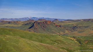
I don't often drive the Succor Creek Road. Though it winds through a beautiful canyon, it tends to be more populated than other parts of Owyhee, and there are plenty of less-crowded roads that lead to the really special spots. Still, with a trip that was all about changing up my strategy, I decided that wandering down the canyon on a Wednesday at the beginning of spring was probably one of the better times to do so, and I soon found myself amazed at the contrasting green and orange surrounding me.

This FJ Cruiser hit a top speed of about 3mph, and I completely understood why.

After pulling over in this camp site for a few minutes, I made a mental note - perhaps camping here on my final evening would be a nice way to end the trip!
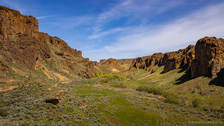
Climbing out of the south end of Succor Creek, the green floor was a sight to behold.
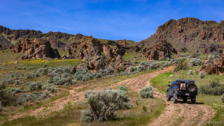
The trip through Succor Creek also afforded me the opportunity to take a road I'd never previously travelled, west towards Three Fingers Rock and the trailhead at Painted Canyon. Except for a bit of new terrain, I didn't really expect anything special from this road, but at this time of year, it proved difficult to travel more than a quarter mile without feeling as though I was in a wonderland.
I felt like I was driving into the orange.
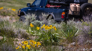
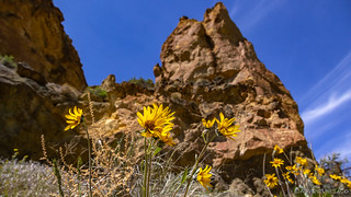
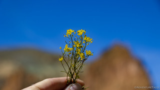
Wildflowers all around! (Balsamorhiza Sagittata - Arrowleaf Balsamroot)
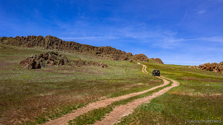
It was nice to get off the heavily graded gravel road and onto a two-track, all the more prominent with a fresh growth of grass.
Soon, I approached Three Fingers Rock - one of my favorite features in the canyonlands - from an angle I've not previously experienced. Only an hour into my journey, I reminded myself that I'd never get where I was going if I kept stopping for photos... as I applied the emergency brake and hopped out of the truck.

I didn't notice when I took the photo, but I like the prominence of the fence line in the grass where cows have been grazing.
At this point it was already noon, and with a nine-mile hike in front of me - before a three-hour drive to my planned camp location - I really did need to pick up the pace for the final push towards Painted Canyon.

Just one more stop. 
Eventually, I did arrive at the trailhead, and I quickly transitioned from driving to hiking mode. Mostly, this entailed putting electronics in my pockets rather than various mounts in the Tacoma, and without further ado I used the inReach Mini to send a quick message that I was now on foot befor trekking off into the canyon.

At least I knew I was in the right place!

Almost immediately, I found myself in a rather steeply descending wash, with several medium-sized dry falls that I had to descend.

I'd say there's a bit of iron oxidation going on.

I wasn't the only one enjoying the sun! (Anise Swallowtail)

Oh, to fly!
As I'd set off along the Painted Canyon trail, I hadn't really known what to expect. In fact, I'd not heard of this hike until a few days earlier when I started researching places to go, but the few reviews I'd found suggested that it was a nice one.
Actually, the hike - as I'd seen it documented - was always described as a loop hike, connecting Painted Canyon to its neighbor to the east, Carleton Canyon. However, I'd also read that there wasn't much in the way of views through Carleton Canyon, and in the spirit of my out-and-back-themed trip, I decided I'd simply hike down Painted Canyon and turn around - still a nine-mile excursion.
Best decision ever? Maybe. 

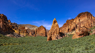
After dropping down through the narrow head of the canyon, it opened up a bit. I'd arrived.

The volcanic geology in this area - Painted Canyon is part of the Honeycomb Wilderness Study Area - is just so fabulous, a little arch sitting high above.

There's no question as to why these formations are called "Honeycombs."
Hiking down the canyon was remarkably easy going. One of our first forays into the Owyhee Canyonlands back in 2016 was a hike to The Honeycombs, just a couple canyons west of Painted Canyon. I'd remembered that hike as being a serious slog - something I'd been a bit worried about when I'd found this hike - but with the scenery in Painted Canyon starting immediately and the incline relatively gradual for much of the journey, I found myself wondering how the best hike in the Owyhee's had eluded me for so long!

Green and orange around every bend.

Outcroppings of volcanic tuff reaching for the blue sky.
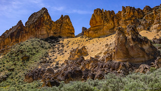
The colors here reminded me of Utah, though this is no sandstone!

Honeycomb sunstar.
Wondering how long this wonderland would last, my progress on foot seemed to mirror my Tacoma-based travel earlier in the day - slow. In fact, I soon found myself wondering whether I should be ignoring some of the scenery, since I'd experience it again on my return trip, and if I was stopping in both directions, I might end up back at the trailhead sometime around sunset. Or, maybe I should make it a loop, just to save myself time on the way back!

Honeycomb window.

Water stained.

Cave view.
Finally - after a couple hours - I made it to the mouth of Painted Canyon. It was striking how quickly the landscape changed - the volcanic formations giving way to the sage-covered hills so common in Owyhee. Beautiful, but no match for what I'd just experienced; what I wanted to experienced again!

Looking back where I'd come, the green of spring winding it's way amongst the jagged rock.

Robed woman feeding a beaver.
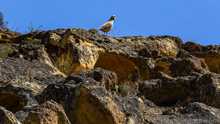
As I soaked in the mouth of the canyon, this Chukar Partridge taunted me from on high.
Having decided that I'd make a concerted effort to enjoy myself at a less leisurely pace on the way back, I stuck with my original out-and-back plan as I re-entered the canyon.

If only I could just keep walking.
I couldn't just keep walking.

Hiking up the canyon was like entering a cathedral, even more than my trip down had been.
In the end, I did make better time on the way back than I had on the way down - thank goodness - and it was just after 5:00pm when I found myself ascending the last of the dry falls before reaching the trailhead. With sunset at 8:15pm, I had just three hours to cover a series of trails that I expected to take all of that time - assuming of course, that I didn't run into any trouble along the way.

Almost back.
From Painted Canyon, I had approximately 65 miles of bumpy backroads between me and my planned camp on a formation seemingly called The Tongue. A long, narrow plateau reaching out into the Owyhee Canyon and looking down onto Lake Owyhee, it seemed like a great place for sunset and sunrise, and I'd hoped to arrive with plenty of time to get setup before our big ball of fire dropped below the horizon. I knew now, that it was going to be a race.
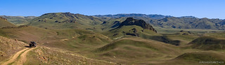
Rolling hills of green as far as the eye can see.
Still a bit of snow up on the top of Mahogany Mountain, around which I would be driving.

I'm not sure I've seen so many cows grazing in the Owyhee's as I did on this trip.

Going solo.
It was as I was nearing Mahogany Mountain that a Swainson’s Hawk rose up out of the sagebrush along the side of the road, a four-legged furry bundle falling from its grasp. Bummed to have ruined its dinner, I drove a little way up the road before stopping the Tacoma and returning on foot, hopefully to witness a retrieval of its prize.

My approach did not go unnoticed.

Target acquired.

A blurry attack!
Excited to have seen the hawk do its thing, my stomach reminded me that - even if the sun still hung in the sky - it was time for dinner. Unfortunately, the digital clock on my dash suggested that dinner now would most definitely mean that I'd arrive to camp well after sundown. I pushed on, south along Mahogany Gap Road, to - what I expected to be - an intersection with Mahogany Creek Road. Except that instead of an intersection, I found an old homestead!

Seeing the flag flying, I wasn't sure if someone still lived here.
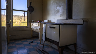
A little poking around answered my question - while ranchers might occupy the cabin sporadically, it was no longer a primary residence.

When you're really into angus.
Wandering around the homestead turned out to be advantageous in more ways than one. While the intersection I'd been looking for was nowhere to be found, I spotted a faint trail that seemed to lead in the approximate direction I'd hoped to travel, and figured that - if I was to stand a chance at arriving before dark - I ought to give it a try.
Which was a great idea, until the road dead-ended at the edge of a 4-foot deep beaver pond!
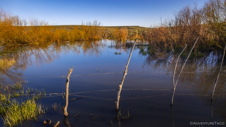
Seriously, beaver!?
After squishing my way through the sticky mud in my muck boots - looking for some way across, but finding nothing - I retraced my route for several miles, convinced that any hope I had of arriving before dark was now lost. Ultimately though, it was another unmarked trail that connected me to Fish Creek Road, saving me from an additional 25 miles - half of them heading east to Highway 95 on Mahogany Gap Road, before retracing those same miles west - on Jordan Craters Blowout Reservoir Road, just a little to my south.
Needless to say - as it became apparent that I was going to find my way through - I was elated! Still, I'd soaked up valuable time as I'd investigated my reroute, and the sun was already on the horizon as I passed an abandoned cabin along Upper McCain Spring Road at the base of The Tongue.

This cabin has seen better days, but the setting seemed perfect to me as I passed it on my way to camp.

Headed out on The Tongue, the colors I'd hoped to enjoy from the edge spilled across the sky above me.
Having allocated three hours, my three-and-a-half-hours journey to the edge of The Tongue meant that I enjoyed the sunset as I drove, rather than - as I'd planned - from the cozy confines of the tent, after leisurely deploying camp. Still, as I looked out over the vast wilderness below me - the wind gusting to 40mph - I couldn't help but marvel at the wonderfully beautiful glimmer of the river as it flowed north under a purple sky.

After a cloudless day, a windy evening brought visual interest to the sky and color to the landscape below.
At this point, I had a decision to make - brave the windy conditions out here in the open, or look for an alternate location to setup camp for the night. I wrestled with this decision for quite some time - on the one hand, hoping to get a quiet night sleep, on the other, knowing how much I would enjoy waking up in this place.
Looking back now, I think I knew the answer to where I would camp even before I considered looking for an alternate location - the draw of camping on The Tongue just too great to be denied - and soon I was orienting the Tacoma into the wind and setting up the tent in what would be one of the windiest nights I've endured.
Still, with earplugs, and after a long day on the road, I hoped that the gusts would rock me to sleep, rather than keep me awake. Only time would tell, but no matter the outcome, I knew that I had another day of out-and-backs to enjoy, and that was enough to put a smile on my face as I closed my eyes on another great day in Owyhee.
Spring Flowers of Day 1
Usually I sprinkle a flower here and there throughout a story, but I saw so many on this trip that I figured I might as well save them up for the end of each post and highlight them as a group where the variety of color can really be enjoyed.
Balsamorhiza Sagittata - Balsam Arrowroot

Indian Paintbrush
Wild Mustard

Sweet Pea

Showy Phlox

Daffodils


Great write up, thanks for sharing!
You're welcome! Glad you enjoyed it! More to come on this one (and a couple more trips in the works). If you haven't already, you can get emails when I post them, here: https://adventuretaco.com/subscribe/
A most beautiful trip indeed, I love the section of tuff volcanic rocks. I did a session of night light painting down this road to the reservoir. Did you get to see any sheep? Was the trail along the river exposed so you could drive it to Watson's?
Other than hiking I have traveled almost all the roads and trails in the area. Thanks for sharing Dan.
Hey Kenny, I didn't get to see any sheep on this trip (plenty of cows though, the place is crawling with them, given all the spring green grass). For the trail along the river - I've got two more parts of the trip coming, hopefully next week. Maybe Sundday if I can get my act together, hahaha!
Glad you enjoyed the story as always, I definitely find myself wondering - as I wander through an area - when it was that you last enjoyed the same area, and how cool it would be to wander around with you and pepper you with questions about the history!
love that area, are there any petroglyphs in that area? I look but have not found any
I don't know of any petroglyphs in the Succor Creek area, but there are quite a few throughout the Owyhee region, so I'm sure that there probably are some. I just posted the next part of this trip - A Little Drama in the Sky - Out-and-Backs #2, closer to the river - where I found some petroglyphs, if you're interested.
That would be really cool. We usually get out there once or twice a year for some fishing. I always look but haven't seen any. I'll start taking my 6yrld this year, and I am sure he would be interested to see some.
Have you ever done the Rome to Juntura road? Its a pretty short trip, (3 hours or so) and the scenery is amazing.
If you broke down out there it would be a long walk out and cell service is spotty at best.
I haven't done the route from Rome to Juntura, but I have explored the western side of the river (see Owyhee West). We made our way north from Chalk Basin to Nyssa, which was a really fun trip - completely different than we expected when we set out to explore that side of the river for the first time. We'll definitely be back, and I'd like to start near the north end of Fields-Denio Road off of OR-78 - there's a dirt road that takes off to the north there, and wandering through the area between that and Juntura seems like it could be a blast!
Hello: It's been several weeks since I enjoyed reading about your last adventure -- and exchanging a few comments with you. In that time, I have gone on a pretty aggressive shopping spree and, between Amazon and eBay, I have now completed my new collection of Nikon DSLR's and all the necessary accessories. Now, I'd like to learn how you protect all your photographic equipment from becoming contaminated while out on the trail. When I am driving off road, especially in the desert, the interior of my Jeep becomes covered in a fine layer of dust -- even though I keep the windows up and the air conditioner on, with recirculation engaged. There does not seem to be any way to stop those fine particles from intruding. When I was a young man, I foolishly took my new (film) SLR to the beach and it ended up costing me almost as much as I had paid for the camera to have it cleaned and repaired. Therefore, I am very concerned about protecting my gear while I am in nature. I would appreciate you sharing the techniques you employ to keep your cameras safe.
Hi Bil, Congrats on picking up a new camera set up - that's always a fun proposition, even though it's not always fun on the wallet! As far as protecting my gear on the trail goes, the reality is that I'm not all that careful. This is perhaps most obvious in the demise of my first camera and favorite lens! Since that episode, I made a promise to myself that I'd never set the camera on the truck again. As you can imagine, I've mostly upheld that promise - only setting (and nearly forgetting) the camera on the tires or bumper about 5 times since then ?!
In all seriousness though - I have the same dust problem that you do, and my approach is to try to be careful about it, but also to not over think it. By that, I mean the following: my setup consists of one body (R6) and two lenses (one 24-240mm zoom and one 15-35mm wide-angle). As I am changing lenses, I am careful to turn off the camera (thereby closing the shutter) and change the lenses as quickly as possible, and in as dust-free way as possible - introducing as little dust into the apparatus as I can. Besides that though, I don't worry about general dust in the Tacoma. Dust (and even water) on the outside of the camera/lens isn't really that big a deal - at least with the Canon system - as the body and lenses are sealed against weather and dust. I will wipe off the lens glass (with my t-shirt) as I notice it getting dusty, but other than that, I don't do much when I'm out on trips. Lastly - for this body, I purchased CanonCare, which gives me a couple cleanings over a 4 year period. I haven't used any of those cleanings yet, but I plan to use one after about two years, and the final one at the end of the term.
Hope that helps!
The yellow flowers are actually Arrowleaf Balsamroot, not Balsam Arrowroot. The leaves look a bit like arrowheads I guess. https://www.fs.fed.us/wildflowers/plant-of-the-week/balsamorhiza_sagittata.shtml. We have a ton of them around our house in Tahoe.
Thanks Ron!