

Stage 4 of the New Mexico Backcountry Discovery Route - Reserve to Fence Lake.
I don't know if it was entirely due to our disappointment at lunch, but at least partially due to our disappointment in how our visit to Reserve turned out, we decided to forego purchasing fuel in town since we still had half a tank plus 11 gallons in the Military Scepter Jerry Cans. That was plenty to get us the 132 miles too Fence Lake - the end of the next stage - and really, it didn't matter since there was fuel some 75 miles away in Luna.
Or so we thought.
At any rate, ready to be done with Reserve, we headed out - once again on pavement for the first 20 miles.

Blue skies as we headed west. These wouldn't last long.
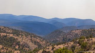
A meandering path first took us southwest - before turning north - and eventually we were back on dirt as we made our way along Pueblo Park Road. Already the sky was changing, the blue becoming gray, the air around us hazy.

Southwesterly winds were carrying smoke from Arizona's fires, less than 50 miles away.

As we climbed out of the taller pine trees, the smoke became even more prominent.
It was most noticeable as we rounded a local ridgeline - to the north, clear blue skies; to the south, smoke.

I hope we're headed into the blue!
Glad the winds weren't so strong in the morning, that's where we came from!
At this point, our track was headed due west, the BDR planners clearly keen to get riders to the Arizona border before turning north to continue the route to Colorado. Of course, that was cool with us, and we were curious to see if there was a Welcome to New Mexico sign at this crossing; we hadn't seen one when crossing in from Utah or Texas.
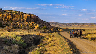
Some cool rock formations here in the Gila National Forest.

Guess we're not entering Arizona - at least not in any significant fashion.
The closure (USFS Order No. 03-01-21-16) affected the entirety of Arizona's Apache-Sitegreaves National Forest and prohibited "going in or being upon the restricted area." The reason, of course was public health and safety due to extreme fire danger. Obviously, a clear and present danger given what turned out to be two large fires burning in the area.
Oh, and there was no Welcome to New Mexico sign at the crossing, though the Arizonian's were kind enough to post that crossing west would result in your being in Arizona. C'mon New Mexico, you're dropping the ball!
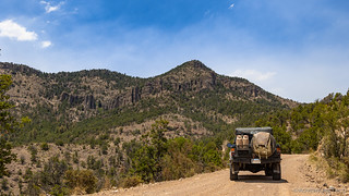
By this point, we were reasonably close to Saddle Mountain, and I'd marked a lookout perched on top, so we made a quick side trip to check it out. At the very least we hoped that we'd get a better view of the fires - though I think both of us were hoping for another friendly lookout operator to chat with!

As we neared the lookout, it appeared to be staffed! 
And as we pulled up to the parking area, we were greeted with a familiar sight - another Toyota Tacoma. I think about 75% of lookout staffers drive a Tacoma, 4Runner, or Toyota Truck. It's awesome.

"Of course it's a Tacoma." -@mrs.turbodb (as she rolls her eyes)
After carefully parking away from any dry material - a fact surely noticed by the lookout staffer - we wandered our way slowly towards the tower, giving ourselves plenty of time to be looked over and evaluated before we requested permission to climb.

Well positioned between two plumes of smoke!
We were invited up and spent 20 fun minutes talking with the woman - who's name we never caught - about all manner of topics. Our trip, of course, but also how her summer was going. Friends with Raszik - who we'd met earlier in the day - she pointed south and noted that while we couldn't see it now, Bearwallow Lookout was, "Usually right over there." Even more interesting was the fact that this - the Saddle Mountain Lookout - wasn't usually staffed. In fact, she was only here because her normal lookout - the Mogollon Baldy Lookout, New Mexico's highest at 10,774 feet - had to be evacuated by helicopter due to the Johnson Fire just a week earlier!
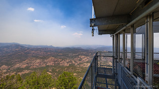
Southwesterly winds pushing smoke from Arizona into New Mexico.

Everywhere we went, there were posted signs praying for rain. It has been the driest few years on record.
After thanking her for everything she was doing and wishing her the best for the remainder of the summer, we climbed back down to the Tacoma and set off to the north. Most striking now was that we'd been completely overtaken by the smoke - it was thick in the air - and everything around us had that orange tinge.

Such a strange sensation. The ground here - obviously - is the color of my shadow, not red as it appears from the smoke-tinted sun.
I was actually quite bummed about the smoke situation - so much of a BDR is about the views from the trail of one's surroundings - but I figured that it was what it was as we continued our trek north. And then - to my delight - as we neared Luna, we drove out of the smoke. It really was that abrupt of a change - almost like driving through a wall - and once again, the skies were blue!

I was so happy to be out of the smoke, I didn't even mind the pavement.
My joy was short lived however, as we arrived in Luna to discover that the lone gas station there had been closed for quite some time; the nearest fuel was in ... Reserve.


Not only that, but closer inspection of the map showed that there was no fuel at the terminus of this stage - Fence Lake - and we'd be cutting it close with our remaining fuel + jerry cans if we tried to push forward. So it was back to Reserve we went - luckily only 20 miles on pavement - to fill up as we should have at lunch. Lesson learned - even when you're grouchy about a poor experience, always get fuel when it's available.

An hour after entering Luna the first time, we were back with a full tank of fuel, the sun a little lower in the sky, but the air still free of smoke.
We pushed north along the western edge of New Mexico, the Gila National Forest once again presenting itself as California; the roads nicely graded and our speeds capped at 50mph only because our tires were aired down to 17psi.

Our regular view.

No time to stop, we're moving right along.

Our first antlered elk, this guy was a loner.
We hadn't been able to see the column of smoke from Saddle Mountain Lookout - the winds had blown it too far and too broadly from its source. Here however, a bit further north and with a different perspective, we got a good look at what was causing all the fuss.

Not a small fire.

We were lucky that all the smoke would remain to our south for the remainder of the trip.
As we neared the northern edge of the Gila NF, it was fascinating to watch the landscape change. It happened first within the forest. Dirt gave way to rocky outcroppings. Then, we popped out into a meadow, a final rocky range and Bill Knight Gap rising up in the distance.

Something is different.

Somewhere in the distance, Bill Knight Gap.
A dozen miles or so later, we found ourselves nearing the gap - really just a pass through the final range, named for some guy named Bill Knight - the significance of whom I never learned. Regardless, the ruins of a cabin - which turned out to be rather pedestrian - got us to stop, and it was a great thing we did - the badlands rising up behind us, striking in their contrast to what we'd seen so far.

Pink badlands. Marvelous!
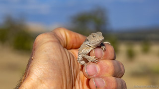
And then, as if the badlands weren't enough, I caught movement out of the corner of my eye. Another horny lizard!

This guy was just a youngin'.
Why'd you wake me from my nap in the sun?

Back where he belongs, still as grumpy as ever.
Now, I've caught more than my fair share of lizards in my life - hundreds if not a thousand or more - but I've never caught a horny lizard before. Heck, this is only the third one I've seen so needless to say I was unsure whether I was asking for trouble with all those little spikes. Turns out they're for show - or at least this guy didn't feel I was any real threat - and once I had him in my hand he felt like any other baby dinosaur I've admired. Just remember - these guys are our friends and they deserve our respect and admiration, please be kind to them.
A big smile on my face, I held my little buddy up so he could scowl at @mrs.turbodb before we climbed back into the truck and a few minutes later left Bill Knight Gap in the rear view mirror. It was getting on 6:00pm at this point, so the shadows were starting to get longer and it was time for us to start looking for somewhere to call home for the night.

Out of the national forest and into the rolling plains.

What do you think - a volcano? (Hint: a volcano.)
As usual, the roads were in great shape, and that meant that even with just over two hours until sunset, we could still pack several dozen miles under our belts. We wouldn't make it to Fence Lake to finish the stage, but that's never a good strategy anyway on a BDR. Rather, you want to spend the night mid-stage somewhere so you can camp out in the open, away from civilization.
The rolling plains gave way to a rocky, mesa-like landscape. Now this is what I expected from New Mexico.

The Cerro Pomo Ranch - marked by a modern petroglyph.

Ruins of the old ranch house? A stable?
We continued through this landscape for the better part of two hours, temperatures still in the low 90s °F, our air conditioning helping to keep things comfortable. Part of us wasn't sure quite what to do - the lack of trees, and sandstone that'd been baking in the sun all day, making for a rather warm existence.
As always, we trusted that something would present itself, and in the end, we were rewarded once again - this time by the Zuni Salt Lake.

That's not ice, it's over 90°F down there.
Surrounded by BLM land, but part of the Zuni Reservation, we hoped to camp at the edge of the lake - a desire that proved impossible when we found the road gated. However, after a couple failed attempts - due to infestations of ants - we were able to find a spot nearby where we setup camp and ultimately spent a pleasant night once the temperatures dropped to something a bit more reasonable.
But I'm getting a little ahead of myself. First, we had a salt lake to investigate.

The salt house. At one time - perhaps still at some times - one must have been able to drive or boat out to this location for the gathering of salt.

Salty reflection.

There were two of these old block buildings, and one crumbling warehouse near the shore.
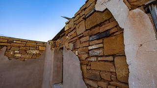
I especially liked the weathering of the interior - the crumbling stucco revealing the craftsmanship beneath.

Fire, the apparent demise of the buildings.
The coolest part of the entire area - for me - was at the edge of the salt lake. There, we had the opportunity to see - up close - the reason this caldera is prized by the Zuni. All along the shore - stretching out across the water - was a salty crust over two inches thick. Pilings, installed many years ago, were covered in the stuff. It was beautiful.

These posts tell a story - of water levels and time. And each is capped with salt that wicked up through the post over the decades.

I'm not sure what type of snake this guy little fellow is, but a few strikes toward the camera suggested that he wasn't as friendly as grumpy horny lizard.
Our investigation of the lake complete, we headed back to camp for a rushed dinner of taco-rritos and guac - a plethora of bugs attacking our headlamps as we ate - plus a few pictures of the sun as it traced its final few degrees through the sky.

Sun star and rays through the clouds.

Camp kitchen.
Sleep would come quickly as usual - long, hot days making for tired campers.
The Following Morning...
Having refrained from reading - in order to keep the lights out and bugs at bay - after going to bed just after sunset, I didn't feel like it was too early when my alarm woke me at 4:35am. Out here in the flats, and with clouds in the sky for sunset, I hoped to get a nice sunrise coming up over the horizon.

Good morning, sunshine.
But hopes are not reality, and the cloud cover was minimal to say the least. There was some smoke however, so I pulled out my chair and grabbed my Kindle and hoped for the best. Nothing really developed, but the orange horizon was still enough to make me glad I'd gotten up, and soon enough I heard @mrs.turbodb stirring as well. It was time to get under way.

Hey, look, more "dirt" roads.
As we'd done the previous evening, we kept the speedometer pegged at 50 mph for the final 20 miles or so to Fence Lake, as we scanned the airwaves with the Kenwood D710G ham radio, which I'd learned to program prior to this trip with the hopes it would give us a bit of listening entertainment.
We were not disappointed. Right away, we settled on a repeater that was being used by the "Made it Through the Night" club, each of the members checking in to let their fellow hams that they were in fact still alive and would check in again the next day. An indication of the average age of operators, perhaps? 
At any rate, the final 20 miles flew by, and by 6:30am we'd reached Fence Lake. This was by far the smallest checkpoint on the BDR so far, the entire "town" consisting of perhaps two intersections. There, the most prominent building was at the base of a cell tower, proclaiming "CellularOne is now providing 3G service to Fence Lake."
Woohoo? 

The only major building besides the cell tower. Perhaps, at one time, a restaurant and bar?

Now, just a porch looking for tumbleweeds.
With no service on our Verizon phones, we didn't stop for long - after all, we knew the highlight of our morning - and perhaps the entire stage of the BDR - wasn't much farther ahead!
The Whole Story


Love Backcountry Discovery Routes? Check out the
BDR Index
for all the routes I've run - they are fabulous!


")
")
")


")
always, always, always tank up with fuel. been there and done the not getting gas and paid the price. great blog, BTW.
LOL, I know and generally agree with you Don! My excuse (though, as we agree, and excuse doesn't make it the right decision) was twofold: First, based on the BDR route info, we expected gas in Luna and had more than enough to make it about 150 miles past that - so, plenty, we thought (the problem was that the next on-route/no-detour fuel we were sure of was about 190 miles beyond Luna, or the 20 miles back to Reserve). And second - our lunch experience in Reserve meant that we wanted to get out of town as expeditiously as possible. Oh well, a 1 hour re-route in a 1200-mile journey isn't that big a deal! ?
Glad you're enjoying the blog, it's a ton of fun to put together, and nice when others can get enjoyment!
I have 40 acres of FenceLake property......never seen it......I don't suppose you saw any HUGE INDIAN CASSINOS there, did you??? lol Thx for another lovely trip where I have never been before. I enjoy your stories as well.