Note: Visiting Cedar Point (and Cedar Mesa in general) requires a pass. For more information, check out BLM Utah Cedar Mesa Permits and Passes Information.
My trip got off to a rough start when my plane from Seattle to Las Vegas was delayed by an hour, just after I arrived at the airport. While it was "only" an hour, I knew that even with my flight south, I had quite a bit of driving to do after I touched down and picked up the Tacoma. Driving that would now extend past midnight, shortening the amount of sleep I'd get for my first day of exploration.
See, I've been itching to get out of California for a while now. Over the last 16 months, a full 15 of my 24 trips have been to the Golden State, and I'm starting to miss the variety offered by places like Utah, Colorado, and Wyoming. Of course, the high elevations and northern reaches are still snowed in, but there's never a shortage of amazing hiking and exploration to be done in the Grand Gulch and Cedar Mesa area So, with a few days to burn, I'd pulled together an itinerary that would take me back in time.
With more than 30 miles of trails, it'd be a literal marathon of R&R - Rock art and Ruins!
Tacoma acquisition and provisioning went smoothly enough once I finally had my feet on the ground. The problem - as it were - reared its ugly head two hours into my ten-hour drive, when I noticed that the ARB fridge - which has worked flawlessly and that I've loved for the last six years - wasn't cooling. This was especially strange given the fact that it had worked just fine on our last trip to the Mojave Preserve, but after a little in-the-field debugging, I realized that the quickest way forward - for now - was to simply convert the fridge into a cooler. I could deal with the actual problem, later.
So, after an unplanned stop for two, 10-lbs blocks of ice, and a couple stops for fuel, I found myself pulling into a windy camp site - just north of Mexican Hat, Utah - a little after 2:00am local time. The trip hadn't even really started, and I was already exhausted.

Sunrise came and went without my even realizing it.
By the time I awoke the sun was well above the horizon and the tent was nice and toasty despite the relatively cool temperatures I'd enjoy for much of my spring trip to southeast Utah. As such, it was more of a struggle than usual to haul myself out of bed and down the ladder for what I'd planned as a short, leisurely stroll along the base of Cedar Point.

In the distance, the formations in the Valley of Gods reached into the sky.
Figuring that lunch wasn't all that far away at this point, I quickly stowed the tent and headed out for what I'd thought was a three-mile roundtrip to several rock art sites...
When visiting rock art and ruin sites, be respectful.
This is most easily done by following the Leave No Trace principles; leaving the place exactly as you found it and taking with you only photographs and memories. In case that is not clear enough for some reason, here are examples of respectful behaviors:

As I headed out of camp, Cedar Point was looking majestic in the mid-morning light.
Of course, as I set out, I had no idea that a hike I'd planned for two hours would end up taking four, so I moseyed along looking for petroglyphs, excited for each one I found. And boy, there were quite a few.

The first petroglyph I found was in the Basketmaker style. (0-500 A.D.)

The next panel had quite a bit going on.


Two of the anthropomorphic figures. One was tall and skinny, the other (a woman?) seemed to have a purposefully-carved hole in a rather conspicuous spot. This was also only the second spider I've seen, the other recently discovered in the Mojave Preserve.

This panel was especially interesting as the faint bighorn sheep seemed to have been carved behind the rest of the smaller figures and dots that made up the panel.

A more focused view of the bighorn sheep.

I'd see a lot of Duckhead Man on this trip.
While the true meaning behind the Duckhead Man petroglyphs will likely never be fully understood, a few possible interpretations - based on the cultural and historical context of the Ancestral Puebloans who created them - are that the Duckhead Man represents a shaman who could transform into a bird and fly to other realms; that he is a symbol of water and fertility, since ducks are associated with rivers and lakes; or, that ducks were the form taken by Katsina (spirit beings) when travelling.

It wasn't every large boulder that was covered in petroglyphs, but many were.

A closer look.
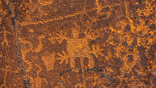
This was an unusual figure.
One thing that I always find amazing about rock art is that the canvas - as it were - generally seems unchanged since the patterns and figures were etched hundreds or thousands of years ago. Of course, desert varnish has returned in some cases, and a few sandstone fins have cracked in others, but in general, the period of time is not long enough to make a dramatic difference.
In the case of one boulder near Cedar Point, not only has time intervened, but it did so as the art was being added to the surface. Well, probably not as the art was being added, but during the same time period.

Tipped Over petroglyphs.

Once right-side up.

This marker's been here for quite a while.

Time is slowly recapturing this figure.

These were simple, but I liked the brightness and the green contrast.

With lots of poking around, unusual views often presented themselves.
By this point I was starting to get hungry and even with all the poking around in various nooks and crannies, it was taking longer than I expected to cover the "out" portion of the hike. In fact, I was more than two hours into the ordeal when I took a closer look at my track and I realized I'd actually mapped seven miles of trail! That, plus the inevitable searching for art - which often adds significant additional distance - and the couple hours I'd slept in, suddenly gave me pause as to the itinerary I had planned for the rest of the day. Yep, off to a good start! 

The final panel I'd planned to see - a line of dancers!
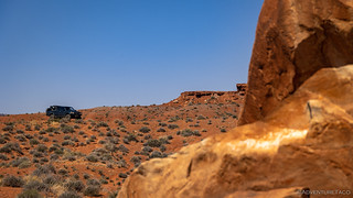
It was after 11:00am when I finally saw the Tacoma in the distance.
Way behind schedule, I could have made up a little time by skipping lunch, but having purchased the fixings for some deliciously spicy turkey sandwiches with hot peppers from In-N-Out, there was no way I was going to let the opportunity for belly-filling pass me by. It was a good thing too, as the next segment of my day also took longer than I expected, an indication that - in my excitement to get to Cedar Mesa - perhaps I was trying to squeeze in just a little too much.
As usual.

Headed west - towards Muley Point - in search of more rock art along the base of the mesa.

The landscape here is dramatic, the San Juan River carving a most circuitous route through the desert.

In places, the road seemed to encroach on the canyon walls.
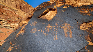
Dotted Man.

Billboard panel.

Another great Duckhead Man. Notice how the one on the left has bird hands and feet, while the one on the right has human extremities.

Grumpy lizard wishes to be left alone.

I don't know if I'll ever tire of this landscape.

Let's hope this doesn't become a trend.
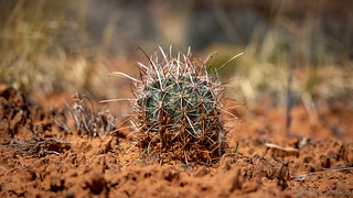
I don't generally think of seeing Fishhook Cactus on Cedar Mesa, and this one hadn't quite gotten its spring color on. (Sclerocactus parviflorus)
Winding my way west, the next 15 miles presented a series of rock art panels. The first of these went quickly enough - the road graded and smooth, speeds of 25mph not uncommon. But, halfway in - after crossing a water-filled wash that surely marks the turnaround spot for most - the road got significantly rougher. It wasn't anything to worry about with the proper vehicle, but as I'd refrained from airing down, it meant dropping my speed dramatically.

A few bumps in the road as I got out in search of a nearby panel.
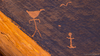
This guy really gets around.

Big boulders everywhere, even the "blanks" were a dramatic sight.

Lost in the rocks.

This was the first Kokopelli Man I'd encountered on the trip, and I really liked how he was connected to the sheep!

Kokopelli was a fertility god, usually depicted as a flute player and known as a playful prankster and storyteller.
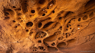
As I was poking around, I stumbled on this amazing tafoni. I didn't realize it at the time, but it wouldn't be the last of this trip!
Eventually, I reached the end of the road - or at least, as far as it was going to take me - and got the truck flipped around for the return journey. I'd skipped a couple of sites on my way out, leaving myself a few stops on the way back.

It was a little after 2:30pm when I headed back the way I'd come, and I enjoyed the views just as much the second time through!

Broken Man. Note how the petroglyph continues onto the varnished surfaces of a once larger rock.

The Obelisk.

More dancers, but these appear to be sitting, the panel appropriately named, "Men on a Bus."

I really liked this vibrant panel of a hunt.

Back on the smooth road.
Somehow, even with my constant forays into the rocks, I'd managed to make up a bit of the time that I'd fallen behind earlier in the day, and it was 4:00pm as I transitioned from dirt to pavement. Headed north now - toward the Moki Dugway - I hoped to continue my exploration of Johns Canyon before making camp for the night.
Time wasn't on my side, but I hoped that if I could keep from getting too distracted along the way, I might be able to squeeze in a few ruins before the sun set. Of course, distractions are the name of the game in places like this, and I'd soon discover that today was no different!


The road you took on the bench, below the cliffs, and toward Johns Cyn was the site of a heinous murder in 1935. It is quite a story and told well in "The Disappearances" by Flagstaff writer Scott Thybony. The book also gives the stories of Everett Reuss, and of a third young man, all of whom were subjects of searches at roughly the same time.
Wow, very cool, I'm going to have to check that book out of my library and give it a read. Thanks for the heads up Anthony! ?
Fantastic documentation of your journey. You do a great job of time things together and making it interesting. Well done.
Thanks Mark, glad you enjoyed the story! There's more coming for this trip (that I found even more interesting), so I hope you'll come back for those bits! If you aren't already, you can get emails when I post them by clicking here: https://adventuretaco.com/subscribe/
Do you get internet service on the trips you go on? Could you work remotely from some of these places if you ever needed too? I recently separated from the Army, and my plans were too overland full time. Fortunately/unfortunately I got accepted to medical school before I had planned. So it looks like my trip will be postponed about 4 years. It would be sweet if I could work remotely as a doctor while over landing some of these places
Morning Joshua, glad you're enjoying the stories and congrats on getting accepted to med school - that's awesome! I'd say that - at least in the places I go - cell service is spotty at best. For me personally - having worked in tech - I wouldn't consider it reliable enough to work remotely full time, but there are a lot of people who are vloggers/youtubers/etc. who do seem to do this full time, so I'm sure it can be done.
Like anything, I think there are tradeoffs - for instance, the folks who full-time it for YouTube are probably prioritizing the places they go - or the amount of time they spend in places where they end up - based on the quality of the cell signal; I'm not. Those folks may head into town to stay at a hotel or visit coffee shops on a regular basis to access WiFi; not me. Personally, my goal with being out there is being able to be present and enjoy the adventure; I probably wouldn't try to do a job at the same time (though, my age may play a roll in that, I know that work-life has become a lot more intermingled in the last decade or so.)
So, you probably could make the full-time thing work, and even get work done while you're out there - it's just a matter of where you go, and how important it is to stay "connected" while you're out there.
Good luck with med school and whatever you do after!
Amazing pictographs. Cedar Mesa has got to move up my list, of must sees.
Thanks Verlan, always nice to hear when a story is enjoyed. Cedar Mesa is a special place for sure.
Thanks Verlan, always nice to hear when a story is enjoyed. Cedar Mesa is a special place for sure.
Adventure Taco: I always enjoy your excellent photos of write ups. I have commented on some of them. However, this post made be uncomfortable. It is due to the potential for bad actors to exploit this information in this post to deface and remove petroglyphs for profit, for vanity, or just pure vandalism. As a Utahn who has been doing similar but unpublished offroad adventures for the past four decades I have witnessed firsthand the ongoing degradation of Utah's priceless heritage of petroglyphs, Anasazi ruins, redrock wonders, that end up fulfilling some vain cabin-owner's interior design dreams. For years, I have been a part of a group of avid yet protective 4x4 explorers who wish to preserve these spaces and go to great lengths to NOT reveal their locations. The internet makes it all so easy to see things that most would never see. I'd wager that most of your viewers, let's say 99%, will simply admire the petroglyphs and thrill at your photograph and appreciate the description of them. But 1% will imagine how cool they would look on their mantle above their fireplace at Tahoe, or embedded in a coffee table, or a rock in the entry way of their Laguna Beach home and either pay a wad of cash to some desperate person with a truck and some power tools. I've seen this happen. Nine mile canyon has already lost countless treasures this way. I have seen the chisel marks and the broken pieces. I have sat through the "before and after" slide decks. It is heartbreaking and infuriating. I urge you to be careful about what you post. There are some bad actors out there.
Mark, I appreciate your taking the time to leave this comment and I share your concern.
I hope that I am not divulging too much in this particular case, as I've mentioned the name of the canyon - which is quite large - but I've given no information as to where the rock art is specifically located there. Additionally, all of the information I have provided is a small fraction of the info that I found elsewhere on the internet (so it's already out there if someone is looking).
I'm curious as to your thoughts on that, and would also like to share this post: Do you have a GPX for that? for your review.
I'm always open to redacting or obfuscating places that are not well known or where I've shared more than is already easily discoverable. Please always keep an eye out for anything you think falls into that category, and let me know/ask me to redact it. Even in this specific case.
Lastly, I should mention that the remainder of this story also touches on rock art and ruins, so keep an eye out as I continue to share it. Thank you!
Hi Dan,
I'm one of those 99% who sit in my arm chair and enjoy following along with your travels. At 75 years young, I still like to travel with tent on truck... But find those times are diminishing with age.
So I fully understand Mark's point of view. Our lands must be preserved.
But I also want to maybe follow in your footsteps if time allows. To see these things first hand. Conundrum for all three of us!
I'm not looking for an answer, just stating the problem, for those like myself, who wish to see for themselves the beauty and history of our country.
"The Hunt" petroglyph was really interesting to me...
Awaiting your next....
D
Thanks David, it gives me a bit of hope that there are many of us thinking about this same issue. Hopefully those thoughts will continue to the next generation(s), helping to preserve our lands and cultural artifacts.
I had a few points for Mark that I'd love your take on as well (if you'd like to give it). Specifically:
"The Hunt" was a pretty nice panel. It took some searching - even with my pre-trip research to find. It wasn't where I expected it would be. ?
Thanks, and glad you're enjoying!
I think your approach and response was spot on.
As far as me being able to find out where you were?
Doubt it. Your were general enough that I could look up the area, but specifically? Not without research, no. I think you are good.
If I want to find where specifically you've been, I'm sure I could use the various government agencies information on petroglyths and get closer, but that is what I should do if my interest is high.
My take on all this, is to only give information you feel is safe. We don't need anything more. Like I said, if we are interested, we can figure it out with research.
Now you have me wondering how much of this location data is already available on Dyrt, or Gaia or other hiking/overlanding apps. Scary that someone would do that.
Be well and waiting next episode!
David
As many of the petroglyphs you find, still makes one stop and think how long ago was this person/group here. What were the conditions of the land like then? Glad you share this with us!
I find my self thinking the same thing often Bill! I've learned how to identify a few things that I see out there (water, snakes, spirals, etc.) but there's just so much that's still a mystery to me.
One thing I thought was very interesting was The Zipper glyph at Parowan Gap. There (and below the image in my story), they had an interpretation of the entire glyph, provided by the Piute Tribe of Utah! Super cool.