
I didn't discover Nine Mile Canyon in my own research. Rather, after posting a story of one of my trips to some fantastic place in the western United States, a reader - Tim - reached out to me to suggest a few places he'd discovered over his years of exploration.
At the top of his list was Nine Mile Canyon, and a photo he shared with me was enough to make me add it to my list without any further information. Under a blazing blue sky, a panel of petroglyphs overlooked a green valley surrounded by the patinaed red rock; this photo captured precisely what Utah is so well known for, it seemed to encompass everything I could hope for in a single image.

That was nearly 18 months before we headed south. In that time, I'd compiled a plethora of information, and dozens of sites along the not-exactly-nine-mile-long route (it's more like 45 miles, but who's counting) to check out as we wound our way along the canyon floor.
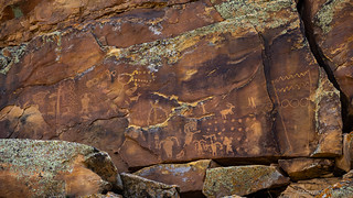
Unlike some of my other trips, this isn't some crazy backcountry drive in the middle of nowhere - the entire trip can be had on paved roads if one pleases - but the sheer quantity of Native American Indian rock art is unbelievable.
It was mid-morning when we entered Nine Mile Canyon from the southwest near Wellington, Utah. Our plan for the next couple of days was to immerse ourselves completely in the dozens of waypoints I'd found along the route, ultimately exiting to the northeast via Franks Canyon Rd, Wrinkle Rd, and Sand Wash to Myton, Utah before heading home.
But - as often happens - we were easily sidetracked. Even before we got to the first rock art site, a (newer) old mine along the side of the road caught my attention and we stopped to take a look.

Owned and operated by Canyon Fuel Company, LLC, prospecting at the Soldier Canyon Mine took place here as early 1906, though actual mining did not commence until 1935. The limited production from the mine was initially sold as home heating coal in Carbon and Emery counties. Over the years, production increased, reaching approximately 1.2 million tons per year before the mine was idled in 1999.

Update July 2023: One year after taking the photos here, the Soldier Canyon Mine has been completely reclaimed. No equipment is left on the site, which is now a graded gravel lot, still surrounded by a fence.
After a little more poking around than I think my cohort was comfortable with, we carried on our planned route, winding our way into the Book Cliffs and to the first of our galleries for the day. Sort of. I hesitate to say we were sidetracked - because then it would seem like I was just repeating myself - but we did make a couple additional stops before seeing our first panel.


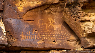
Shortly thereafter, we did finally explore our first petroglyph panel - at Brundage Cove, tucked away behind a stand of pine trees along the side of the road. Poking around for 10 minutes, we'd soon realize that we'd spent about eight minutes too long if we wanted to see everything the canyon had to offer!

From Brundage Cove, we were in-and-out of the Tacoma on a regular basis for the rest of the day. Describing our exploration at each panel would probably be the most boring story I've ever put together, so I'll mostly just share some of the more interesting - historically or personally - panels, along with a few little events that happened throughout the day.
Don't worry - if you were here for material to put you to sleep, I'm sure you can find something that meets your needs. If not in this story, then in another.


There were a few places along the route where we deviated from the meandering flow of Nine Mile Canyon Proper and found ourselves in a side canyon or wash for a particularly interesting bit of art. The first of these was at Sheep Canyon, where a couple-mile trek across a currently-inhabited cow pasture was the order of the day. Luckily for us, it turns out that I'm a cow-whisperer, able to shoosh the terrifying beasts with a lowly rumbled "mooooooove" command.


Back at the Tacoma, we were both getting hungry, so we decided that at the next good pull out we'd have lunch. I quickly revised that plan - after realizing there were pullouts every 100 feet or so - and suggested that we hold off until we reached a panel that I'd been looking forward to seeing more than any other in the canyon: Coyote Places the Stars.

 ) Happy man leading a horse.


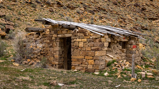
Just before reaching our lunch spot for the day, we rounded the corner to the Winn Ranch. Like so much else in the canyon, it has been abandoned over the years, but it was obviously quite elaborate when it was in full swing. The rock house was well built, and there were several outbuildings along both sides of the road.
Note: There were no signs at this location as we passed through, but I've since been told that this is private property and that the owners do not allow trespassing, since the structures are old and could injure someone should they fall while people are inside. Please respect the area and keep out.


Shortly after leaving the ranch, we arrived at Coyote Places the Stars. Well, we arrived at the viewing location anyway. I had mixed emotions when I discovered that the actual panel was several hundred feet up the side of the canyon, and reasonably inaccessible. On the one hand, this was good because it meant that it was protected from the grubby mitts and bullets of those who so often deface these cool bits of history. On the other, it meant that - given our timeframe - I wasn't going to get to hike up and around the 2 mile trail - to check out the panel more closely.

One legend has it that the Coyote liked to impress the girls by juggling his eyeballs. One day he threw one so high that it stuck in the sky to form the star Arcturus.
According to another Hopi creation myth, Old Spider Woman provides Coyote with a sack filled with stars. After climbing to the top of a mountain he begins to distribute them neatly in the heavens, creating the well-known constellations. Soon, he grows tired of this work and picks up the bag to throw its contents into the sky. This is the reason why many of the stars are not arranged in an orderly fashion.


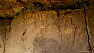
After visiting the Coyote and eating an enjoyable - but windy - lunch, it was time for another short hike up a side wash on the north side of the road. We were in search of owls, which I thought would be really cool, since I've never seen an owl as a petroglyph before.


As we walked back from the Owl Panel, I glanced out into the valley and had a flash in my mind of Tim's photo that got me started on the idea of coming here to Nine Mile Canyon. Even as I look back through the panels that I photographed for the trip, I don't know exactly where he took his picture, but this one still reminds me of it.


Of course, the rock art wasn't the only thing we were enjoying as we descended through Nine Mile Canyon. The canyon itself is quite beautiful, and I can imagine that if we'd come through a few weeks later - or in early summer - when everything was blooming and green, it would have been even more spectacular!


Two-thirds of the way through the canyon is Rassmussen's Cave. The cave - which was excavated in the 1930s - contained many artifacts in addition to the rock art on the cave walls and the metates (worn areas in the rock where corn was ground). Rassmussen's Cave is also home to the famous "No Tresspassing" graffiti which is used in many brochures and pamphlets as an example of how not to treat rock art sites. Apparently, the landowner became frustrated with visitors trespassing on his land in the 1980s that he enrolled the help of local boy scouts to go to the cave and write "Keep Out" and "No Trespassing." Not realizing where they would write the warnings - or that they would misspell trespassing - he didn't accompany them and was a bit surprised at the result. Today, after a land trade with the owner, the Bureau of Land Management (BLM) now owns this property. (roadtripryan)


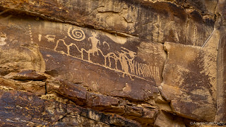
Relatively near Rassmussen's Cave is Daddy Canyon. There are tons of great panels in and around this canyon, and a mile-and-a-half hike is all that's necessary to see them all. We started in the corrals at the western mouth of the canyon and followed the loop clockwise, wrapping up the rock art extravaganza about a quarter mile east, down the paved Nine Mile Canyon Road from the parking area.


Perhaps my second favorite panel next to Coyote Places the Stars.


By the time we wrapped up our hike in Daddy Canyon, it was about 3:30pm I think it's safe to say that we were both entering that point that I suppose I always knew existed, but hadn't ever really experienced myself - rock art overload. We were to the point where - at some of the panels along the side of the road - we'd peer at them out the windows of the Tacoma and declare "panel achieved."
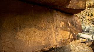
There were two more major sites along the route - that we knew of at the time - so we pulled up our big kid pants and set off on foot for the first of them - the Big Buffalo Panel.


And with that, we headed to the final - and perhaps most widely known - panel on our planned itinerary. This one - located in Cottonwood Canyon - has been recognized as a nationally significant and has used in publications around the globe.

Known as The Great Hunt Panel, this is an incredible display of Fremont petroglyphs. One theory about this panel is that the horned, anthropomorphic figure at the top center represents a hunt shaman. Around the shaman, is a herd of bighorn sheep during a migration; the lines connecting all of the sheep, representing a common ancestry.


As we were slowing making our way east, we ran into a fellow explorer who we know only as Dana, for - as I introduced myself - he mentioned that I was just "missing an 'a'." Dana's been visiting this area for more than 40 years, and he wanted to make sure that we'd stop at the Family Panel on our way out of the canyon. We hadn't known of any panel by that name - though when we arrived, we realized it was already on our list of waypoints - but thanked him profusely as we left him to his hunt for panels he'd never before seen.


And with that, we'd completed our whirlwind tour of the most densely packed rock art we've ever encountered. It was overwhelming, really, and something I'd recommend spreading out over more than one trip - just to keep yourself sane. Even having seen more than five dozen panels, there are surely hundreds more that we missed - tucked behind trees, high on the canyon walls, or just a little further up a side canyon than we ventured.
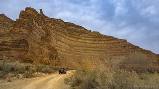
From Nine Mile Canyon we needed to find a way to the top of the Tavaputs Plateau on our way to Myton, UT, and Franks Canyon Road seemed to be the perfect answer to the question of how to gain elevation. After winding our way up the wash for a few miles, we found ourselves in a warm, dusty - and perhaps foggy - abyss as Winkle Road worked its way east toward Sand Wash.

Both of us once again hungry, we found a spur that overlooked the deep canyon to our south and broke out the kitchen for a quick meal. Having learned our lesson on the last trip, this time we skipped the Ramen Noodles, opting instead for our staple: taco-rritos. Full of guacamole, of course.


Eating dinner, it was time to make a plan for the evening. Our options were obvious - look for a place to camp, or make the 1000-mile push towards home. A quick check of the weather forecast suggested that - even though it was currently a balmy 67°F - our present location would see snow around 10:00pm that evening; with that, the decision was made.

It was only just a bit after 6:00pm - and we were a few miles from Myton - when the snow started. Significantly ahead of schedule, it'd snow on us all the way from Utah to Washington, making our already long trip home, that much longer.
But you know what? I'm ready for the next trip!
When you think about what the frontiers of the US was back in the day, that date engraved on the rock is more likely to be 1878, not 1818.
Could be, though the characters look pretty similar. Perhaps an early Spanish explorer or someone from early Mexico?
Another great adventure and another place to add to our "to do" list for the future!
This is a great one. Really quite accessible (paved for the most part) and so much to see. My only recommendation would be to go a little later in the year - early-to-mid-summer would be best - so you get a lush green valley. We were there just a little bit too early.
(and sorry for the slow reply, I just found a bunch of comments that were incorrectly marked as spam, so I'll need to dig into the guts of the site to figure out what's going on)