
March 28, 2019.
It was a chilly night - at least compared to the last - our tents covered in a layer of frozen dew when I awoke in the morning. A quick glance out the window was enough for me to realize that no spectacular sunrise would be visible from our location, so I pulled out my Kindle and finished reading whatever action-thriller I'd been in the middle of at the time.
That didn't take long - there hadn't been much left, so I pulled on a couple layers of clothes and climbed into the truck to finish writing the last chapter of the recent Anza-Borrego trip.  As usual, it was a fun experience but one that took longer than I'd anticipated, and I wasn't completely done before I heard the zipper of Brett (@BossFoss) and Heather's (@MrsFoss) tent - the morning sun having warmed them sufficiently to get up and started on breakfast.

At any rate, that was my cue to wrap things up - my own Cheerios and blueberries waiting to be eaten in the sun. And of course, our ruckus was enough to wake up the rest of the crew, all them them pouring out of their tents in the next 20 minutes or so and pulling up their chairs to enjoy the warmth of the sun's rays.
Which meant it - as was normal by now - it was 10:15am before we got out of camp and on our way to Natural Bridges National Monument. That was fine today - our agenda clear except for a hike through this special place - something Monte (@Blackdawg) and I had added to our bucket list last fall when we'd visited as part of the F.U.Rain trip.


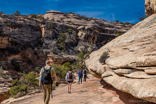
The plan was to hike the full loop - some 9.8 miles - through three natural bridges: Owachomo, Kachina, and Sipapu. It would be a trek for Brett, who's knee was giving him a bit of grief after our earlier hike to Druid Arch, but he was a trooper and plowed ahead with the help of a bit of Advil and Tylenol.
Plus we thought - this hike would be easier, right? I mean we were just walking along the bottom of a wash the entire way.
Mmm, nope. By the time we were done, we'd covered some 14 miles according to our GPSs, and the elevation change was nearly twice what we'd hiked through a couple days before.
But I'm getting ahead of myself.
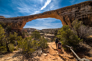
We dropped down into the canyon on the south end of the loop, near Owachomo bridge. I don't know if this was the most spectacular bridge of the three for everyone, but it was for me. Towering above us as we made our way down, the angles of it's arch, and the views it framed were breath taking.


So distracted were we by the bridge itself that we lost the trail for a short period of time, having entirely missed a reasonably obvious sign that should have kept us on track. Not a problem for us though - that meant another view before heading the right direction down the canyon.

Before we'd set off on the hike, we'd stopped in at the visitor center to make sure we were squared away with our fees, and to inquire about the conditions of the trail. We'd been told that there was more water this year that normal, and that the trail had been quite muddy just four days before. With warmer weather this week, we hoped that we'd have no trouble - and for the most part that turned out to be exactly what we got.
In fact, I think we hit the hike at exactly the right time of year - water flowing along the wash next to us, cascading over rocky areas, it's sound rhythmic and peaceful - but the trail dry and the day warm. We couldn't have asked for more, really.


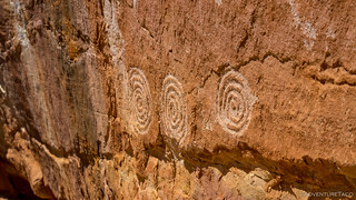
And then, as we were making our way around a bend in the wash - looking for a way to cross without getting wet, Brett turned around and pointed up on the side of a cliff. "Are those petroglyphs?" he asked, catching us all off-guard.
As it turns out, Monte had marked some ruins on his original route, but of course none of the rest of us had looked at that before setting out - so we had no idea that we might continue our record ruin run. And, even better - these petroglyphs weren't ones that Monte had marked. Without Brett's keen eye, we'd have walked right by, like so many other hikers must every day.


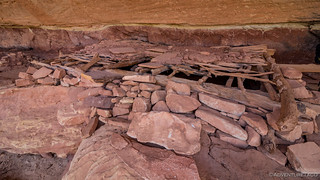
Keen to get a closer look, we found our way up (these side trips are what would turn our 9.8 mile hike into some 14 miles) and were greeted with some of the best petroglyphs we'd seen yet, and a ruin to boot.


We also found an ammo box - something we initially thought must be a geocache, but instead turned out to be a congratulatory note from the National Park Service, letting us know that we'd found a secret ruin - one of many throughout the monument.
One of many you say? Challenge accepted.


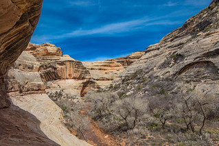
We continued on, meandering along with the wash, eventually making our way north, but not without a lot of east and west thrown in the mix. Having gotten a bit of a late start, we were all starting to get a bit hungry, and we looked for a nice place to stop for lunch - our criteria as simple as a nice view, a bit of shade, and a bit of sun.


It didn't take long to meet those criteria - essentially the entire hike described in those simple terms - and so we plopped down to each sandwiches, chips, fruit, and more - all while taking in the sun and watching the local wildlife soar above.


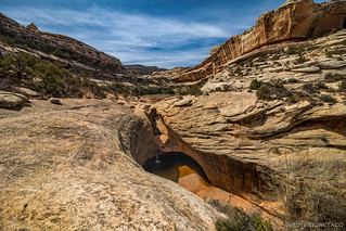
It was nearly 2:00pm by the time we decided we needed to press on - more than half of the hike still in front of us, our pace slow as we soaked everything in. And as we did, we rounded a bend where the wash plummeted down into what looked like one of the most refreshing swimming holes we could have possibly found. Alas, today we could only admire from above.

Then, further down the wash - in fact, at a spot where two washes came together - we rounded another bend to find Kachina Bridge. Though hard to tell in person, it is larger than Owachomo but significantly smaller than the third bridge we'd see this day - Sipapu. And, as recently as 1992, approximately 4,000 tons of sandstone fell from the inside of the bridge, enlarging it as it has no doubt been enlarged time and time again over the millennia.

For a while, we hung out in it's shadow - taking in the grandeur, listening to the creek echoing around the arch in the stone. Each of us capturing the memory the best we could, and in our own way.

And then, a nice surprise. Brent (@PcBuilder14) looked at the map Monte had put together and suggested that there might be some ruins nearby the bridge. So we ventured that direction, hoping that we'd find something cool. Which of course, we did - it was another "secret" site!

Like the last, this one had a small set of ruins, and also several petroglyphs and pictographs. And, relatively new for us at this site - red hand prints on the sandstone - perhaps a family recording their presence here hundreds of years before.


As we admired the find, we heard another hiking group show up back at the bridge. Unsure if they'd find these ruins, we kept quiet and did our best to wait them out before heading back to the trail and continuing on our way. Unfortunately, having thought that they'd continued on, we made our way out in full view of their group - a bit worried that we'd exposed a lesser known ruin.
But, we needn't have worried - I don't know if the group just wasn't thinking about ruins, or didn't even know they existed, but they greeted us as though we'd been hiking the "normal" trail, and we watched them as they continued along their way, never the wiser to the secrets the canyon held!
A bit relieved, we pressed on - the views continuing to unfold in front of us. Even the manzanita in bloom as we walked by.


Along the way, we spotted more ruins of various sizes - most of them unmarked - some of them worth exploring. And by some, I mean every single one that we could access. 


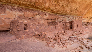
And then, in the distance - and requiring a bit of a scramble - we saw the Horse Collar Ruins. Unlike other ruins in the monument, this is one that is well-known enough to have it's own overlook - though most view it from several thousand feet away as opposed to in-person.
Even so, Horse Collar Ruin - like the other sites in Natural Bridges - is one of the best-preserved Puebloan sites in the area. Named after two structures with doorways that resemble horse collars, it's believed that Native American Indians last left the area over 700 years ago - the site's remarkable state of preservation due to the isolation of the Natural Bridges area. With only a few visitors, Horse Collar Ruin's kiva still has it's original roof and the interior hasn't been disturbed.

We hung out for a while - enjoying the times when we'd see other visitors on the trail below - completely oblivious of our position and discovery above them. And enjoying even more the times when we'd see visitors at the overlook above - gazing down on the ruin, surprised by our presence - so out of place we must have looked as we relaxed in the shade before continuing along the trail.
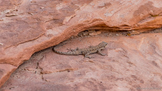
Wishing we could stay longer, we eventually left the Horse Collar Ruins - guarded by our friend, the blue-bellied lizard - on our way to the final bridge - Sipapu.
Before we got there though, we spotted - on an overhang - a series of hand prints. And not just any series of hand prints - there were literally hundreds of them. In awe, we ventured over and it took us a good several minutes to realized that something was wrong.
And then, I figured it out - nearly all of the hand prints were fakes - added to the wall by hikers who'd used the red mud from a the nearby wash to add their own print next to the few original prints that had been painted with boiled agave juice.
Not cool folks.

Real pictographs, unraised, and made with boiled agave juice.

Fakes (or at least, present day) hand prints, made with red mud.
As we discussed how these fakes could be dealt with by the park service (and frankly, whether they even cared), we rounded another bend and in front of us was the largest bridge of the bunch - Sipapu Bridge. At 220 feet high and 268 feet wide, it's nearly twice as big as the other bridges. Formed over thousands of years, and subjected to countless floods bearing scouring rocks and sand, it will someday collapse and erode as part of the endless cycles of time and change.
We were lucky to be able to see it before that happens.


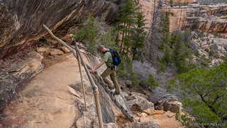
And then, it was time to start heading up. 13.5 miles behind us at this point, we had some 700 vertical feet to climb, and we were all tired. We pushed on, up ladders and stairs - grateful for those who'd come before us to make the climb easier than it would have otherwise been.


Finally back at the trucks, we were ready for a nap - not that naps were an option. Instead, we piled into the two trucks we'd left at the end of the trail and caravaned back to the trailhead, where we'd parked the other two trucks. This was especially fun for me - Devin riding in my passenger seat, with Monte on the slider for the short trip to their truck. Her comment out the window, "Monte, look how clean it is in here!" 
All back in our own trucks, we started looking for a camp site along the highway between Natural Bridges and Hite. Aired up at this point, we wondered if we'd made a mistake - the county road we'd thought would be graded and well maintained, a bit rougher for the wear after a winter of snow and rain.
But the views were nothing to complain about - Bears Ears once again in the distance.

In reasonably short order, we got ourselves to camp. It wasn't without a bit of searching, and some new pinstrips for the extra-wide 3rd gen in our group - but the site we found seemed well sheltered and had a nice view, so we weren't complaining!


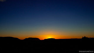
Our last night camping together, Monte built us a great fire out on the cliff's edge and we enjoyed the fire as the sun set to our backs - yellows, oranges, and blues on one horizon, pinks and purples over Bears Ears on the other.


Our fire lasted longer on this final night of the trip. We'd decided that the next day - a Friday - was the day we'd all head for home, Monte hoping to install some new lower control arms in Powell, Brett and Heather, and Brent getting home in time to rest up a bit before work on Monday, and me making the long trip back at a bit slower pace - perhaps stopping somewhere fun for a final night of camp along the way.
Even so, we'd gotten use to our early nights, and it was 11:30pm when we doused the flames and said our good-nights. The next morning we'd pool our remaining resources for a big breakfast - bacon, eggs, and more - before heading north towards Hanksville where we'd finally part ways.
At least, that was the plan when we went to bed. But you know how it is when you make plans without knowing what mother nature has in store!


Great article, and excellent pictures. I came to the site because we had hiked from Sipapou to Kachina Bridge, then hiking over the mesa back to the car. We wondered about the wall with all the handprints, suspecting they were not real. Thank you for your insight and excellent Blog. Keep it up!
Hey Greg, that's a pretty cool blog you've got there, I've bookmarked it for more reading! And, glad to have answered your question about the handprints!
Appreciate the sharing of the adventure, especially since I'm sure to never be able to see it in person.
Sure thing John, glad you enjoyed it! This one was from a while ago, but boy, it got me hooked on Natural Bridges, and I always find myself looking forward to the next time I'm there!
I thought the natural bridges hike was a loop, or did I misunderstand what you said? Wouldn't you leave and return to the same trailhead?
Hey Jane, The hike can be done as a loop, but the "top half of the loop takes place outside of the canyon, crossing the plateau, to return to the parking lot where you left your vehicle. To give ourselves a break, we parked one vehicle at the point where you descend into the canyon (near Owachomo bridge) and another where you climb out of the canyon (at Sipapu Bridge). That allowed us to drive the "uninteresting" part of the loop, which just makes its way through trees, with nothing to see. Hope that clears it up for you!