
Perched above I-10 and the Chuckwalla Valley - which for some reason, I'd previously assumed was on the south side of the Chuckwalla Mountains where the Bradshaw Trail passed through the Chuckwalla Bench - I was relieved when the previously rambunctious winds died down after sunset. Having gotten very little sleep the night before, I fell asleep quickly and slept soundly - perhaps my best night of sleep the entire trip - waking well-rested about a half hour before sunrise, so I could get an early start to my day.


My plan for the day was simple, in theory. I needed to be in Las Vegas to drop off the Tacoma by 5:00pm, which meant that I could poke around in the mountains until a little after noon. Surely, plenty of time for a six-mile hike and mine exploration. Except, not really.
Now in my usual perpetual rush to squeeze in one more thing - for which there must be some medical condition, perhaps one that would afford me a blue handicap hang tag  - I pressed the skinny pedal a little harder than usual as I made my way north on CA-177 to a faint dirt road leading towards the mountains to my west.


Having assembled all my hiking gear - only to remove it for the previous photo - I picked it all back up again and continued on my way. With a couple miles of alluvial fan to cover before I even reached the base of the mountains, I resolved to stop exactly zero more times, to allow myself just a bit more time exploring the camp and any old mining structures that might exist.
It turns out that when I'm not stopping every few minutes to snap a photo of this or that, I can make pretty good time. It was pure torture though - the entire time I was hiking towards the mine, the sun and clouds were constantly toying with each other, light and dark playing across the rocky landscape. It was a thing of beauty and would have been a great drone-captured timelapse.
If I liked to shoot video. Or had a drone. Right, well, never mind.


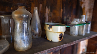
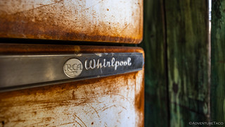
Heading to the nearest cabin first, it was easy to see why the National Park Service has become sensitive to the mistreatment of this place. The cabin was in rough shape - as were all of the structures I'd find - and it was clear that most things of value had been removed. What a bummer.

The site was visited in 2004 and posted online anonymously by Guy Starbuck as the “Moss Mine” in 2013 when it still had an ore cart and numerous steal signs where used to line the walls. Death Valley Jim visited the site and documented it on-line anonymously as the "Mystery Mine" in early 2015. Not long after, YouTube mine explorer Frank Hood posted the ██████████ on his channel publicly ‘outing’ the mine and its location. By the time of our visit in December 2015 the adit had been sealed with a bat gate and the welds were still fresh. Many of the artifacts we saw in previous explorers post were gone, looted. Hence the controversy of weather or not to reveal mine locations despite most are public information anyway.
source redacted
It was after the first cabin that the road forked, so rather than check out the second cabin, I decided to stay on the main road and check out the upper mine workings, first. This meant another mile - and 600 feet of elevation gain - of ground to cover, but this time I let my lack of willpower win, stopping several times to snap a photo of this or that along the way!


With the exception of - what always seem to be - omnipresent mattress springs and the hand painted walls, there wasn't anything of note in or around the workshop. From here though, the road continued up to the upper working, where I hoped to find some old rail leading to a mill that I'd gotten wind of in some of my research, as well as - possibly - an adit to check out.
Exploring into mine adits, shafts, etc. is not safe. I joke around about that a bit in this story, but I just want to be clear: Stay out, stay alive.


Well, a little confused - not a rare or difficult situation for me to find myself in - I realized that I didn't really care if this wasn't what I was expecting, because it was still cool. Plus, there was a door to an adit, and it looked as though I might be able to climb over the single remaining bat gate across the portal door to check out the insides of the mine.


Noticing a faint miner's trail to the south of the adit, I followed it - switching my way back and forth up the hill - wondering if there was, perhaps, another more extensive adit a little further up. After gaining a couple hundred more feet - nearly to the ridge - I only found some minor prospects and it was clear that - likely just as the original miners - I was on a wild goose chase.


Having poked around for a little longer than I'd planned - looking for the workings I'd expected to find - I realized that time wasn't on my side as I headed back down to the cabins. Still, now having hiked four miles, I wasn't about to head back to the Tacoma without checking out the fork in the road.
Because seriously, who needs to be on time for a plane flight home when there's an old, abandoned road to explore in the middle of nowhere?


The road from the cabin wrapped around a fold in the hillside as it continued up an adjacent canyon to the one I'd just explored. Much shallower than the first, I hadn't mapped this side road at all - good job me (!) - but I knew that if I didn't check it out, I'd surely find out that this was where all the good stuff was once I got home. So, up I went!
It didn't take long to realize I was right. This may seem like a good thing - I didn't miss a cool part of the mine - but let me assure you that it is not. It simply reinforces my propensity to make poor choices when it comes to timing. 


It was, naturally, the door into the mountain that interested me the most. I blame Mike @mk5 for this entirely, as I've previously not ventured very far into adits. However, his excitement when we were exploring the Dale Mining District, and the fact that he'd left me with a few of his little colored LED puck lights, meant that I was now looking for ways to use them.
And there's no better way than in a 100% totally safe hole in the ground.

A decade ago - according to information I found in my research - there was an operational ore cart on in this adit. Removed by looters, the NPS installed the bat bars to prevent additional vandalism, and to try to keep the few remaining artifacts in place for future generations. For that, I'm grateful.


Needless to say, I was pretty excited as I exited the adit. Unfortunately - as I mentioned previously - the excitement only reinforced my desire to continue up the road to another working further up the mountain. I was surely pushing my luck by now, but I didn't care - I had colored LEDs to take advantage of!


Unlike the lower adit, the upper adit was only a couple dozen feet deep, and besides a steel cable anchored to one of the walls - used to ferry ore down to the mill - there wasn't much left for me to admire. Thank goodness, because as it was, I'd need to maintain a near-jog in order to get back to the Tacoma and on my way to Las Vegas!
It was nearly 1:00pm when I reached the Tacoma. With a four-hour drive ahead of me, my usual 62mph cruising speed wasn't going to cut it - I'd need to hit the speed limit, and then some. You know, like a normal person.
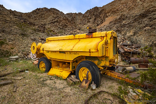
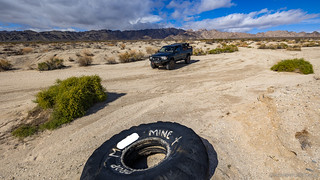
First though, I had to get back to pavement, which naturally proved difficult. First, how was I supposed to pass by an old drag tire - used to grade the road - from the mine I'd just explored? Then, when I crossed over a structure that - surely - should have been full of water... obviously, I needed to get a photo.
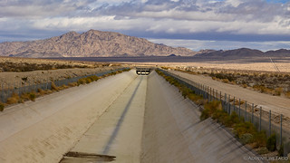
Luckily, it was only a few miles to CA-177 where I supposed that pavement would present significantly fewer distractions. I was right - for about twenty minutes. Shortly after turning east onto CA-62, I knew I had to stop.


From there, it was nearly a straight shot to Las Vegas on US-95. Completely out of character, I found myself passing other vehicles on the two-lane highway as I raced north. As I did, the skies opened up as the eastern front of an atmospheric river - one that would dump two feet of snow in Death Valley and more than ten feet at higher elevations in the Sierra - enveloped the highway.

Now in cell range, @mrs.turbodb texted to ask if my flight had been cancelled. Luckily, it hadn't. Yet. I continued to race north.
In the end, I made my appointment to drop off the Tacoma with three minutes to spare. From there, the trip to the airport was uneventful - if a little wet - and the flight home was uneventful.
I'm already looking forward to my next visit.


Another fine adventure that I'm glad to have experienced vicariously since I'll never be there myself, THANK YOU! I'm always saddened when I see a fine site that was vandalized/looted and I'll never understand why people do that. They will steal things, take them home & realize they have no use for them and they'll end up in the trash. About 60 yrs ago 2 friends of ours had a mining claim near Red Mountain & 5 to 10 of us would often camp there, improving the site and just camping out. We built a shack, cleaned up a shaft of about 25' depth, dragged the road, etc. Our experience is that if vandals can't find something to steal they will burn and shoot up things instead. Our solution, since the dirt road went up a narrow canyon surrounded by higher walls, was to dig a pit across the road deep enough that vehicles could not cross it (put some tank trap type steel at the bottom). It stopped the vandalism and when we went up we had 2 planks to span the pit.
It's disgusting to what lengths vandals will go to get their thrills. It doesn't matter how old they are, be they 7 or 70. A lot of times I would like to blame their parents, but that's not always true. It goes both ways, believe me I know after working in the local school district for over 25 years. It's either some parents' kids, or some kids' parents. Your solution is genius. If they attempted to drive through the pit, there would be thousands of dollars worth of damage to their car as they dropped the nose of their car to the bottom of the pit. I hope it was at least four feet deep and impossible to see until they were in it. A tow is also very expensive. Did you ever catch anything in that pit?
The trench/pit was the width of the road, a little over 3' deep and the sides were shored up with timbers, it was a little over 3' long, and there were some rebar spikes in the bottom. Before the trench we had "No Trespassing," signs and a steel cable across the road. We were NOT trying to trap anyone or damage their vehicles, only protect our friends property and mining claim. We never saw any evidence of someone trying to cross the trench. There was no easy way around it as the shoulders on each side of the road were at least 8' high & no evidence that anyone had tried to go around it.
Your picture of the car says it all. It wasn't enough to shoot it full of holes. So they cave the roof in and burn it. There's a car at Augaberry's camp in DV that suffered the same fate. Speaking of which, Russel's Camp, one of my favorite places to visit in Butte Valley had a kitchen table and chairs in Russ's kitchen where he used to hold court with the area miners. He posted a bunch of pictures above the table where one could sit and visit his life while having a feast and a couple of cold one's at the table. Some low life took everything, pictures and all. Many of those pic's are in Emmitt Harders' book 'These Canyons are filled with Ghosts'.