After a very pleasant night - temps in the low 40s °F, only a slight breeze - on the southern edge of Pinto Basin, I was up bright and early to make the 12-mile drive back to the intersection of Pinto Basin, Old Dale, and Black Eagle Mine Roads. I'd gotten out of camp just before sunset, knowing that I had a full day ahead, and knowing - even if I didn't admit it to myself - that each of my dozen or so stops would take longer than I imagined.
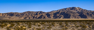
As I sped across Pinto Valley, the sun crested the horizon and lit up the Pinto Mountains to my north.This was a strange enough cloud formation that I had to stop and grab a photo. Within an hour or so, it was gone.
By 7:00am, I'd reached the junction. Once again I'd avoided any semblance of a fee station at which to show my America the Beautiful pass, though at this hour on a Sunday, any that I'd have encountered would have been closed. Now on pavement - a surface I hadn't seen for several days at this point - I headed north across Pinto Basin, towards the heart of Joshua Tree.
A good chunk of JTNP is comprised of Pinto Basin. (red)
It is hard to imagine the existence of large bodies of water anywhere in this parched landscape, but exist they did. Here in the Pinto Basin evidence of old shorelines lends proof to a cooler, wetter period when a shallow river coursed the basin. The river attracted life, which explains the fossil bones of extinct camel, horse, llama, sheep, tortoise, and rabbit found here. It also explains the discovery of a distinct human culture that camped along the riverbanks.
Between 1931 and 1935, self-taught archeologists Elizabeth and William Campbell searched up and down this valley. They followed the ancient rivers and terraces for miles, discovering many small campsites and collecting chipped stone tools—leaf-shaped points, scrapers, and choppers. The Campbells recognized that these tools were different from others of the region. When the artifacts were radiocarbon tested years later, they registered more than 9,000 years old and confirmed the existence of a vanished people - the Pinto Culture.
One of the few vehicles on the road at this early hour, I moseyed along at a leisurely pace, stopping at every roadside information sign - each of them preceded by at least one "caution, exhibit ahead" sign - as though they were bound to jump out onto the road at the last moment.
Looking back, this may have been a mistake. I could have used the additional 23 minutes of daylight - though even that wouldn't have been enough, and would surely have been consumed by some other meanderingly-slow activity - as I searched for a camp in the black of night.
Still in the largely-unpopulated section of the park I made a quick stop at Porcupine Wash to eat breakfast and find the petroglyphs I knew were somewhere along its banks. I also began my cataloguing of cacti - an activity I would thoroughly enjoy the entire time I was in Joshua Tree. In fact, I'd argue that the cacti here are more interesting than the Joshua Trees, which are more plentiful, larger, and more photogenic in both Death Valley National Park and the Mojave National Preserve.
As I searched for rock art, this cholla seemed to glow in the morning sun. It would be the first of many varieties of this god-awful plant that I would encounter.It struck me how similar these symbols were to the symbol that cartographers use to indicate a spring. Of which, there appeared to be one behind these rocks.Bladder-Pod. (Isomeris arborea)
Continuing north, I passed by Turkey Flats and the base of Pinto Mountain as I continued to gain elevation, climbing out of Pinto Basin and toward two of the strangest gardens one can hope to encounter - one of Ocotillo, and another of Teddy Bear Cholla. Frankly, at this point - now an hour or so inside the park - I was starting to wonder two things: first, where are all the Joshua Trees? Second, I always envisioned this park as being one that was a wonderlands of rocks - similar to City of Rocks or Alabama Hills. And yet - so far - I had yet to encounter any decomposing granite. What gives?
Turkey Flats isn't really flat (it's an alluvial fan) and Pinto Mountain is 3,983 feet tall.One of the larger Ocotillo I encountered as I wandered through the patch. Apparently - and to my surprise - not a cactus.The thorny, multi-stem shrub is in fact a woody deciduous plant. Unlike other deciduous shrubs, which normally grow leaves in the spring and drop them in the fall, the ocotillo may grow and drop leaves as often as five times during the year. Its leaves aren't season dependent but rain dependent.A leafy ocotillo I'd seen a few days earlier in Anza-Borrego.
After wandering around trying to find the perfect ocotillo shot - an activity I generally enjoyed, though that probably appeared to passers-by as a weirdo making random turns in the desert - I drove only another mile or so before the landscape changed entirely.
To one of pure evil.
Pure evil. (Teddybear Cholla, Cylindropuntia bigelovii)Mosquitoes of the cactus family.
Seriously, if you've never experienced a cholla before, count your blessings. Anyone or anything that so much as looks at one of these cacti will immediately feel its wrath. Not only will the segments - each with thousands of barbed needles - pull off of the main plant at the slightest touch, but the damn things are purposefully shed - littering the ground with obstacles worse than land mines. Seriously, spreading these over enemy territory would compel unconditional surrender within minutes.
Cholla balls. Of evil.Don't let the flowers fool you. Pure. Evil.
I'd encounter more cholla over the remainder of my stay, but never at the same density as this torture chamber. Where they'd built a parking lot. And where I saw - in the 15 minutes I was there - more than one small child wishing they'd listened to their parents. Remember kids, stay the trail.
Glad to be done without being viciously attacked - except for a dozen or so cholla balls I accidentally stepped on and subsequently had to pick out of the soles of my shoes while praying to the deities of every religion to keep me safe - I pushed on to my first long(er) hike of the day.
As with the nearby Dale Mining District, Joshua Tree had its fair share of mining activity prior to its designation as a National Monument in 1936 and Park in 1994. I'd visit a few of these mines over the course of my stay, and up first was a loop past the Silver Bell and Golden Bell - two gold mines in the Hexie Mountains.
The ore bins of the Silver Bell - once used to feed a stamp mill and amalgamation table - overlook the north end of Pinto Basin, and are visible from the main road through the park.Colorful ore still decorates the hillside. The Silver Bell first worked gold in the 1930s, then lead in the 1940s and copper in the 1950s.A little azurite is always a fun find. (But leave it there when you're in a National Park.)Looking down from the Silver Bell towards the Golden Bell.
Having conquered the uphill section of the loop on the way to the Silver Bell's ore bins, it was pleasant traversing a trail that's downhill - and no longer heavily traveled - between the two mines. Expansive views and a few encounters with the current residents were more than enough to put a smile on my face.
Mr. Spider was in a rush to get where he was going.Mr. Lizard was content to lay in the sun.Mr. Pencil cholla is evil, but not pure evil like his teddybear cousin. (Cylindropuntia ramosissima)There wasn't much left at the Golden Bell mine - an ore chute, dump pile, and cyanide tank were all the equipment remaining (and of course, some sealed shafts).
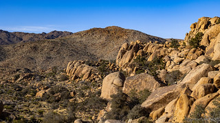
It was after hiking the Hexie Mountains that things really started to change; when I realized that people are talking about Joshua Tree, they're actually talking about a very small part of a reasonably large place. It happened to coincide with the transition from Colorado Desert to the Mojave Desert as I climbed in elevation through Wilson Canyon.
It was there - at White Tank - that I hit the Wonderland of Rocks. And people.
Now, this is what I was thinking of when I pictured Joshua Tree.
The first thing I'd planned to visit was Arch Rock. I'd envisioned it as a short loop that'd wind through the rockery, leading to an arch that I could find a cool angle to photograph, and then continue on my way. What I hadn't envisioned was that the trailhead would be at a campground - and that the short loop would be a highway.
Following the trail, I soon arrived at Arch Rock and realized that not all national parks are like Death Valley, where I can go days without seeing another soul.
I should have also realized at this point that the camping situation would be a little different than that to which I'm accustomed, but I wasn't sharp enough to realize that, yet. And of course, it'd be too late when I finally did!
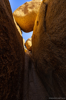
For now, I dove off the side of the main trail and into the wonderland of rocks. Like other wonderlands, I hoped that there'd be plenty of cool nooks and crannies to discover; places just far enough off the trail - in some cases even just a few feet - that the hoards would simply pass them by.
Reflected light.This looks intriguing...Narrow passages and chockstones.Dark to light.Heart rock.
In the end, I spent quite a bit more time wandering around than I'd planned - likely a result of my first exposure to the big pile of decomposing granite that I'd been looking forward to - but eventually I found my way back to the Tacoma and continued on my way.
By this point it was right around noon and the once-lightly travelled roads were now crawling with vehicles. Realizing that this was going to be a slightly different experience than the one I'd had just a few days earlier in the nearby Dale Mining District, I quickly panned through the list of places I wanted to see and tried to sort them by a combination of proximity and popularity. This would allow me to visit them efficiently, but also try to visit the busy ones first, leaving me with a more relaxing experience for the remainder of the trip.
In the end, that turned out to be a fantastic exercise that resulted in a much more enjoyable time in the park. Plus, as a bonus, my next immediate destination was a cross-country hike where the likelihood of running into others was nearly nil - the Pinto Wye arrastra.
Yep, another arrastra!
I jumped like a scared toddler when I flushed a nesting cactus wren out of this evil Silver Cholla. (Cylindropuntia echinocarpa)One of the coolest arrastra I've seen.
Wagon Wheel arrastras are a bit of a rare breed, not too many of them are known to still exist. This one seems to have two wagon wheels joined together as its pivot mechanism. Originally driven by a four-horsepower International upright gasoline engine that drove a belt that spun the arrastra.
Local legend claims that the first operators of the mill used the wagon wheel as the pulley, but found it went too fast. They then added the larger, wooden wheel to reduce the revolutions per minute. I'm not sure if that's true or not, but it would seem to make sense.
Neat to see the drag stones still chained to the wheel.
The builder of this wagon wheel arrastra is unknown. It was probably used in the 1930s. The arrastra was powered with a gasoline engine, using a belt around the central wheel. Earlier arrastras were usually powered with animals, steam, or water.
Historic engineering record, National Park Serivce, Delineated by Ruth Connell, 1991.
Gold ore, water, and mercury were placed on the circular stone floor. Several stones were dragged around the floor, crushing the ore and mixing it with water and mercury. Mercury combined with gold, forming what is called an amalgam. This amalgam was then heated, separating the now gaseous mercury from the gold. The gold could be sold to the United States Mint, used in trade, or used to purchase goods.
This arrastra, named the Pinto Wye Arrastra because of its location, is on the National Register of Historic Places as an Important example of nineteenth and early twentieth century milling technology.NPS sign
Making my way back, I noticed - but didn't investigate - one of the shafts above the arrastra. And, only on my return, did I discover that there is a small mine camp in some nearby boulders. Something to look forward to next time!
For now, I was headed to what I assumed were three very popular sites where I suspected that a quick photo or two would be all I could muster before feeling the urge to escape the crowds on another longer hike.
Site 1: Split rock. (left) | Thumb rock. (right)Site 2: Face rock. (left) | Site 3: Skull rock. (right)I think I enjoyed this rock garden nearly as much as the tourist traps.
Continuing west, I hoped that I was mostly done with the crowded parts of the park - not that I wasn't part of the problem - leaving me with longer, more remote hikes for the duration of my stay. For now, I was headed to the Desert Queen and Eagle Cliff mines, a 3.5-mile roundtrip that would consume much of the rest of my afternoon.
As I headed toward the Desert Queen, I wasn't worried about losing the trail. Ironically, I lost it about three minutes later.This old structure was curious, as there was no entrance to the far room from any side. Perhaps it'd been restacked by NPS over the years?
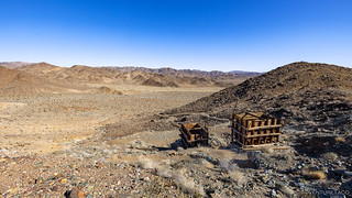
The Desert Queen is one of the largest mines in the park, and while it wasn't spectacularly successful, it was sufficiently productive to remain in operation for nearly seventy-five years.
First discovered in 1893 by Frank James - who was working as a miner over at the Lost Horse Mine - a local rancher named Jim McHaney soon learned of the rich lode. Legend goes that he and a few other cowboys: Charlie Martin and George Meyers, decided they wanted the Desert Queen mine for themselves. One day, in April 1894, they visited James at his cabin, during which time one of the cowboys, Charlie Martin, shot James twice and killed him. Martin claimed self-defense and was acquitted at an inquest - conveniently held at the McHaney Ranch - the following year. McHaney, his brother Bill, Martin, and Meyers quickly took control of the mine and began to develop it. Gold ore was hauled to the two-stamp mill at Pinyon Well for a time before eventually being hauled to the Wall Street Mill.
In 1895, McHaney purchased a five-stamp mill from the Baker Iron Works of Los Angeles and erected it at their Desert Queen Ranch (now known as Keys Ranch), while at the same time buying out Marin and Meyer's shares of the mine in order to consolidate control.
It didn't take long for McHaney to squander his newly found fortune and by 1896 he and his brother Bill were forced out. Controlling ownership of the mine changed hands a few times but by 1902 it was owned by S. F. Zambro, who was a banker from San Bernardino. Zambro continued to work the mine and, by 1907, the mine had reportedly produced over 3,700 ounces of gold.
In 1907, the mine changed hands again when William Morgan invested nearly half a million dollars to develop the mine further. The new shafts and workings did not find any rich new gold ore, though. Morgan hired Bill Keys around 1910 as mine supervisor. Morgan died in 1915 and the mine transferred to Keys who continued to work and lease the mine periodically until 1961, producing a few hundred ounces of gold in that time.Desert Queen Mine
Today, the Desert Queen - four vertical shafts, five inclined shafts, and ten horizontal adits - is mostly in ruins.This old single-piston engine is one of the few pieces of machinery still on site.
I didn't spend much time at the Desert Queen, as the more interesting destination was actually the Eagle Cliff Mine, a little more than a mile further along the trail. This mine, while not unknown, seems much less frequently visited and - I had heard - was the location of a pretty unique cabin that I was excited to check out.
Along the way, this Dollarjoint Pricklypear was looking fine. (Opuntia chlorotica)Holey rock.It was fun to realize that the views along this trail have probably stayed the same for thousands of years, and wonder about the people who'd travelled this way before me.
Forty-five minutes and some tricky route-finding later, I found myself at the site of the old Eagle Cliff Mine. Much smaller than the Desert Queen, it was discovered by Robert Muir in 1895, and a 75-foot inclined shaft was dug to follow the main vein of gold. By 1916, Bill Keys owned the mine and while it generally sat idle, some minor production was carried out by his brother-in-law, Albert Lawton, in 1933. Burros packed the ore to Keys’ Wall Street Mill where it proved to be - like the majority of mines across the west - relatively unprofitable.
It was time to start hunting for the cabin.
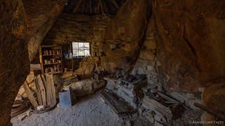
First I found a little cave with what I can only assume is a bit of modern graffiti.Found it!
I was quite excited when I found the cabin. Built into the surrounding rocks, it would turn out - like the arrastras I'd see on this trip - to not be one of a kind, but that didn't make it any less thrilling to discover. If you go looking for it, please be sure to leave everything you find, so others can have a similarly fun experience.
Looking out the front door.The main room.Kitchen cabinet.
By now it was nearing 3:45pm. With a little more than an hour of daylight - and knowing that I had a couple more places I wanted to check out, plus the need to find somewhere to camp - I made good time back to the Tacoma, somehow limiting myself to no photos on the return trip. Talk about willpower!
Figuring that I should find a camp spot first - and realizing part way through the day that the only camping in Joshua Tree is in campgrounds (the horror) - I pulled into the Hidden Valley campground just after 4:30pm.
Full.
Finding a ranger, I inquired as to the status of other campgrounds in the park - curious as to where I'd have the best chance of finding an open spot, as they are all available on a first-come-first-served basis.
Politely, but also clearly a little incredulous, I was informed that the campgrounds generally fill by noon; there was no way I was going to get a spot.
Well then. That was a problem I was going to need to deal with. Later. There was nothing I could do about it now, so I thanked the ranger and headed off to find my treasure for the day - one of two "lady" pictographs I'd search for in the park.
Meet the Brunette Red Lady pictograph.
Thrilled too have found my final bit of rock art for the day, I was headed back to the Tacoma - to actually figure out what I was going to do for the nigh, since I had to sleep somewhere - when I noticed this skinny, narrow arch out of the corner of my eye. I don't think there are many arches in the park, and I don't know how well-known this one is - I'd not heard of it - so it was a fun discovery to cap off the day!
At first I wasn't sure if it was an arch.But then, blue sky!
Taking a quick look at the GPS, I realized I had two choices: 1) I could drive back into the Dale Mining District and find a spot on BLM land to call my own for the night, B) I could head into a remote region of the park - Covington Flat - and hope that I wouldn't be disturbed by anyone at the end of some road, somewhere.
Knowing I probably wouldn't make it to Covington Flat for any other reason, I decided that I might as well see if I could find a nice place in that area to camp, even though it'd take an hour or so just to get there. And so, with my lights ablaze, I headed north, west, south, and northwest again until I found myself perched at the top of Eureka Peak.
The only one for miles, I was far from alone.
Deploying the tent and making a quick dinner, I gazed out over Palm Springs and hoped that the 10mph winds would remain calm through the night. If they didn't, this wasn't going to be fun.
Fantastic trip! And I especially got a kick out of your depiction of the Teddy Bear Cholla. Mary Lou and I have had encounters with those spiky bastards also. One time, in Kofa, we decided we wanted to take a couple of those nasty pieces that fall off the mother cactus. You weren't supposed to take anything from the area so we were trying to be quick about it. Well, as we both tried to gently acquire one, Mary Lou got one stuck on her hand and I got one stuck on my foot just as a car pulled up. We were trying to look casual but it's kind hard when you have an agent of the devil stuck to you. The people left after a short time and we wrestled with removing them from our bodies and then the remaining spines. We finally did so and needless to say, we didn't take any of those spiny sons of guns with us! UJ
turbodbApril 9, 2023
Man, those things are the devil! I too made the mistake of picking one up about a year ago - trying to move it into the perfect light for a photo. Turns out I moved it into my fingers instead, and was in no mood for a photo once I freed myself from those damn barbed spikes.
I've since heard - from some folks obviously smarter than me - that the best way they can be removed is using a comb. Apparently, there are even special combs for the purpose, though I'd think that a cheap plastic one would be just fine.
JimApril 10, 2023
Oh, that's "funny". Yeah, those "balls" that fall off the plant are deadly. Some people in Ajo call the plant the "jumping Teddy Bear". Many people, including us when we remember, carry a comb when on a walk in the desert, especially for the dog. UJ
Jeri M ChildsApril 11, 2023
This is such a stunning series.............thanks so very much for sharing.
turbodbApril 11, 2023
Sure thing! Glad you're enjoying it and hope you enjoy the rest of it as well (there are 3 more to come ?).
John EdmundsApril 11, 2023
Several of the rock formations remind me of Hole-in-the-Wall in the Mojave National Preserve near Nipton, it’s a very scenic trip.
That said, we just got back from Mojave National Preserve and wow, was I reminded of Joshua Tree on one of the hikes we took. Eerily similar as we trekked along near the Granite Mountains. Of course, you'll have to wait for that story to come out to see where we were, exactly. ?


Fantastic trip! And I especially got a kick out of your depiction of the Teddy Bear Cholla. Mary Lou and I have had encounters with those spiky bastards also. One time, in Kofa, we decided we wanted to take a couple of those nasty pieces that fall off the mother cactus. You weren't supposed to take anything from the area so we were trying to be quick about it. Well, as we both tried to gently acquire one, Mary Lou got one stuck on her hand and I got one stuck on my foot just as a car pulled up. We were trying to look casual but it's kind hard when you have an agent of the devil stuck to you. The people left after a short time and we wrestled with removing them from our bodies and then the remaining spines. We finally did so and needless to say, we didn't take any of those spiny sons of guns with us! UJ
Man, those things are the devil! I too made the mistake of picking one up about a year ago - trying to move it into the perfect light for a photo. Turns out I moved it into my fingers instead, and was in no mood for a photo once I freed myself from those damn barbed spikes.
I've since heard - from some folks obviously smarter than me - that the best way they can be removed is using a comb. Apparently, there are even special combs for the purpose, though I'd think that a cheap plastic one would be just fine.
Oh, that's "funny". Yeah, those "balls" that fall off the plant are deadly. Some people in Ajo call the plant the "jumping Teddy Bear". Many people, including us when we remember, carry a comb when on a walk in the desert, especially for the dog. UJ
This is such a stunning series.............thanks so very much for sharing.
Sure thing! Glad you're enjoying it and hope you enjoy the rest of it as well (there are 3 more to come ?).
Several of the rock formations remind me of Hole-in-the-Wall in the Mojave National Preserve near Nipton, it’s a very scenic trip.
Interesting. I always think of Mojave's Hole in the Wall as being more "swiss cheese," and I've definitely been reminded of it, but mostly by Hole in the Wall at Death Valley (at least, "swiss cheese" wise).
That said, we just got back from Mojave National Preserve and wow, was I reminded of Joshua Tree on one of the hikes we took. Eerily similar as we trekked along near the Granite Mountains. Of course, you'll have to wait for that story to come out to see where we were, exactly. ?
You can get emails when it does, of course: https://adventuretaco.com/subscribe/
Great photos and story. Could you share what camera and lenses you are using? Thanks!
Hey Neil, Glad to hear you enjoyed the pics and story (there are plenty more that I hope you enjoy as well).
Here's my photo setup: Involuntary Evolution to a New Camera and Glass, snd my approach to taking photos: If You Take Enough Photos, Some Are Bound to be Decent.
Happy to answer questions if you have any! ?