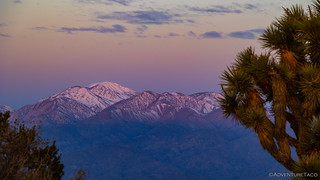
Boy was I lucky. My night at 5380 feet on the top of Eureka Peak was a little cool - not a problem given my doubled-up down comforters - with just the slightest breeze to keep air moving through the tent. It was a far cry from the wind event that was bearing down on the region - and that I'd suffer through over the remainder of my visit - but I woke up well-rested and looking forward to a beautiful day!
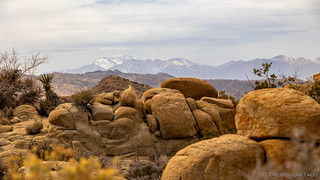
A little alpenglow on San Gorgonio Mountain just before the sun crested the horizon.A bit of sun dusting the San Jacinto Mountains, the clouds still ablaze with color.
Though I was technically camped in Joshua Tree National Park, I new I needed to get an early start to my morning; I had quite a trek to get back to the main part of the park, where the hikes I'd planned for my day were clustered.
First though, I wanted to make a stop at Coyote Hole Canyon. Located outside of the park, and only a few hundred yards from the nearest houses, this special canyon contains a concentration of petroglyphs that will rival any found inside the park itself.
Coyote Hole is well-known to the locals, who have worked over the years - and continue to do so with the Native American Land Conservancy, an inter-tribal group which, among other activities, acquires “threatened cultural landscapes” - to preserve and keep this special place cleaned up.
After visiting, I learned that there is apparently new signage at each of the main access points stating that non-tribal visitors are not allowed without permission. I didn't run into any of this signage on the rather circuitous cross-country route I took, but please respect any signage you encounter.
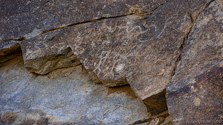
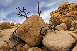
A smooth, 15-foot dry fall initially stymied my search.As I bypassed the fall, I happened to stumble on this yonic fertility symbol, which I've never seen anyone mention in the context of this area.
Having marked a location on my GPS, I'd expected to find the petroglyphs reasonably quickly. However, upon my arrival, I searched for a good 15 minutes, eventually finding only a single very faint set of glyphs.
Though they were faint, it's always a special experience to find petroglyphs.
Not knowing if this was all there was to find - and thoroughly enjoying the experience of being in this peaceful canyon itself - I retraced my circuitous route to the Tacoma, ready to head into Joshua Tree proper.
It was in the Tacoma that I happened to pull up a few photos of the area - other trip reports that I'd researched prior to my visit - and realized that I'd definitely missed the main attraction of Coyote Hole. Torn between going back and looking again, or just continuing on with my day, I probably sat there for a good five minutes before hopping back out of the truck and heading back into the canyon.
On my second visit - as I reached the main wash - I ran into Bob. A member of the Serrano Tribe, he was quietly walking up the wash, along an invisible path I can only assume he's traveled many times before. Greeting me with a smile, he reached out his hand as he asked my name, and how I found myself in Coyote Hole. Relating my story and after hearing his, he gazed up at the walls around us, "This is such a beautiful place in the morning. There is so much history here, I hope you enjoy it," he said.
It was an interaction that became the highlight of my visit - all due to my failure to find the petroglyphs on my first attempt, and my decision to head back a second time.
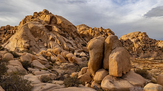
A short time later, I found the petroglyphs I'd been looking for.Many of the glyphs were high on the canyon walls.Geometric shapes dominated the site, with only a few recognizable figures.Time takes its toll on rock art, though I quite like the jagged edge of this rock where it split off.
Covering the same ground for the fourth time went quickly and soon I was on my way into Joshua Tree National Park, only a few minutes after 8:00am. Still, the line of cars at the entrance station was already a quarter mile long, making me glad that I'd entered the park via the routes I had prior to this point.
Showing my America the Beautiful pass once I reached the entrance station, I was waved through - no colored card (as one receives in Death Valley) to put on my dash - and within minutes I was parked along the side of the road in an unmarked turnout. This was the trailhead for my first six-mile hike of the day. I was headed to Samuelson's Rocks.
Across the desert, all alone.This was a cute Hedgehog Cactus I ran across. (Echinocereus engelmannii)
Though this is not an "official" hike in Joshua Tree, there are several other trails that are crossed - or followed briefly - along the way, some of which have seen improvements, perhaps by the CCC.
Stairway through a desert garden.
Mostly downhill from the trailhead to a valley with a small, rocky hill that Samuelson and his wife once called home, I made good time as the sun rose into the sky. Glad for the sunscreen I'd applied, I found myself wishing that I'd also brought along a windbreaker - a westerly wind periodically picking up and pushing its way through the lightweight, long-sleeved shirt I've taken to wearing for sun protection and its ability to breath - especially as I reached the rocks and my hat was nearly blown from my head!
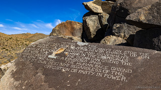
Rock 1: The Rock of Faiht and Truht. Nature is God. The key to life is contact. Evolution is the mother and father of mankind. Without them we be nothing. John Samuelson, 1927.
After finding the first rock, I set out to find the remaining six.
Rock 2: Religion is a code of moralls for us to live by no more. Hell is here on this earth no other plase. Moast of it we make our selfe as to haven find it in a lifetime. Nothing proven after death by preast of scientist?Rock 3: Mother time. Neither wealth laws nor army's can stop the human mind from creating new or emprove up on the present day. Religion and goverment. Water is saft onley hard in the chemicall's but with time the ocean can griend the hardest granit to a powdered sand. So with time will the human race griend out it's own destiny's regardless of the opposition or party in power.
John Samuelson moved to Joshua Tree in 1926. A Swedish immigrant, he initially worked for Bill Keys as a ranch hand and miner at the Hidden Gold Mine near Keys View.
However, a year later, Samuelson left Keys employ to work his own claim in Lost Horse Valley. Building a small cabin with his wife Margret, this is where he would spend his free time carving his views into the varnished granite stones nearby.
Atop the pile of rocks, this old bedframe still rests where the Samuelson's cabin once sat.
Unfortunately, after filing for a homestead, it was ruled that as a non-U.S. citizen, he could not legally hold the land’s title. Defeated, Samuelson sold his claim and he and his wife moved to the Los Angeles area.
In 1942, Samuelson was arrested for murder after getting into an argument - and then killing - two men at a tavern in Compton. Before going to trial he was declared insane and was sent to a state hospital in Mendocino from which he escaped four years later and fled to Washington State.
For more than two decades Samuelson worked as a logger until, in 1954, he sent a letter to Keys indicating his desire - and hesitancy due to a fear of being caught - to return to the desert. Shortly thereafter, Samuelson was involved in a logging accident and died from his injuries.Petro-Prophetic Words Hewn In Stone
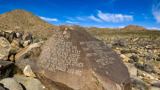
Rock 4 (side 1) Wake up you take and bond slaves. A politician is a bird that get's in on the tax payors poket book for a fat rake of and his free keep's. He lead's you by the noose with one hand with the other he digs in your pocket. A freind of the banker and big business why?.
Rock 4 (side 2): Ar eyou the fellow MrMellow that grabed all our dough. Ain't you better up and tell us. Where in the hell did it go.Rock 5: God made man but then Henry Ford put wheels under em. Thoa master of the gold'n rule he must die to be aprissiated.Rock 6: Judge Ben Lindsen a man that understands humanety and big anough to live it.
Study nature obey the laws of it you can't go wrong. It payes compound interest for life and not one penny envested.?Rock 7: The milk of human kindness aint got thick cream on it for all of us. Ask Hoover?
Fighting the wind the entire time I was hopping from rock to rock in search of the seven that contained the musings of this strange dude, it was a relief to retreat to the relative calm of the desert floor. That's not to say that the calm would last - in fact, quite the opposite - but at this particular juncture, the only indication of the atmospheric turmoil was high overhead.
The clouds were looking fantastic from below, even if the weather up there was frightful.
Not far from Samuelson's Rocks, I'd also gotten wind of the ruins of an old homestead. I'd assumed that this was where Samuelson lived, but it seems that this wasn't his place. Rather, its owner - like so many others - has been lost to time.
Anyone for a Pabst? The waste pile was the first thing I ran into.Slowly being reclaimed.
From the homestead, I realized that I could take a different - and as a side benefit, more direct - route back to the Tacoma. Completely trailless, but with a view the endless traffic on Park Blvd the entire time, it was a pleasant climb up the valley. Following a series of washes rather than footprints, I startled several jackrabbits - every last one of them quick enough to escape without having their photo taken or becoming dinner.
By the time I got back to the truck it was lunch time. While I wouldn't have complained about eating, what this really meant for me was that I needed to find a camp site for the evening - so I didn't end up in the same situation I'd found myself in the night before. Luckily, Hidden Valley campground wasn't too far away, and after driving through the entire campground I found only a single site - and the last one in the loop - unoccupied.
With no camp host and the first-come-first-served envelopes missing at the pay station, I scratched out a quick note to attach to the site post, left a backpack full of dirty clothes on the picnic table, and made a beeline for the entrance station where I could fork over my $15 to have a spot to spend the night. It would be the worst night of my trip - not because I was in a campground, but because of that pesky wind I've been alluding to. Of course, we'll get to that in due time.
I found it only slightly worrying that the NPS employee at the entrance station recalled another camper reserving this site a few hours before I did.
Happy to have my sleeping accommodations sorted out, it was time for my second six-mile hike of the day. This time, I planned to hike the Maze Loop to a viewpoint of Window Rock - an arch - because, like dugouts, aerial tramways, rail track, ore carts, and views, I'm a sucker for arches.
The clouds in the sky continued to show off as I set off on my loop.
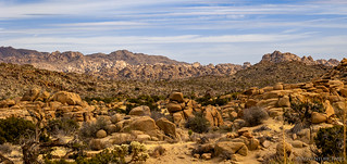
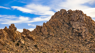
The Park Service calls this loop "The Maze", but for anyone who's hiked more than ten minutes in a Wonderland of Rocks, the naming might seem a little... gratuitous. However, I've apparently only spent nine minutes in Wonderlands because - despite plentiful signage - I immediately wandered half a mile off my intended trail, turning my six-miler into seven.
At least I got some nice views on my little detour.Back on track, this barrel cactus - or is it a cotton top? - caught my eye.Wandering through the Wonderland of Rocks, San Gorgonio Mountain in the distance.If this doesn't scream Joshua Tree...Down, but definitely not out. Amazing how this guy could survive - for quite a long time - having been almost entirely uprooted!
The viewpoint for Window Rock was at the halfway point of the loop, and with a little luck, I caught it with a bit of blue in the sky as the wind whipped the clouds by at a breakneck pace.
It was all I could do to hold the camera steady for these shots.
Wishing - once again, I'm a quick learner - that I'd brought along a windbreaker, the second half of The Maze loop forced me directly into the wind. What had been 40mph gusts were becoming sustained at 30- and gusting to 55mph. But hey, I probably burned some extra calories!
As I headed back to the warmth of the Tacoma cab, this V-22 Osprey thumped by overhead!
It was mid-afternoon when I got back to the truck and enjoyed single serving of powdered donettes. At least, I assumed that the 15 donettes in the bag constituted a single serving, as it was only one bag. Having left the bag in the cab, it was every-so-slightly warm, making the little round cakes ever-so-pleasantly soft. Frankly, I was lucky to have not left a second "serving" laying around as well.
My stomach a little happier, I hoped I had time for a couple more short hikes before calling it a day. Luckily for me, the trailheads were clustered nearby and so after a few miles of pavement I was ready to go. Even luckier, as I was setting out relatively late in the afternoon, there were relatively few other people on these (usually) busy routes - a nice coincidence of hiking these places later in the day!
First up was a short detour to check out a another - given that I'd visited the Brunette Red Lady - pictograph of a red lady. This one - simply called "Red Lady" - was located right along a reasonably popular trail, and yet still went unnoticed by the vast majority of people who walked by.
Red Lady.With the trail winding through the rocks, most people were more focused on watching their noggins than looking for rock art.I found this very deep (8-10 inches) bedrock mortar nearby, which I liked nearly as much as the pictograph.
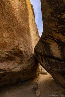
After a successful hunt, I turned my attention to the Barker Dam loop. Only a little more than a mile-and-a-half long, this turned out to be the most pleasant hike of my entire time in Joshua Tree. The light was just right, the crowds were small and reasonably spaced, and the hike's location - sheltered on all sides by decomposing granite boulders and ridges - meant that the winds raging elsewhere in the park were nearly non-existent. I'd finally brought along my windbreaker, and now I didn't need it!
This tree seemed to be hugging a granite buddy.An hour before sunset and filtering through clouds, the soft light made everything seem so calm.If you weren't looking for it, you could almost miss the dam itself.
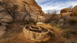
In the early 1900s, ranchers, needing water for their stock, searched for ways to supplement natural water sources. They dug wells, improved springs, and expanded natural catch basins in drainages of canyons and rock formations by building small dams.
This area began as a natural tank, a catch basin for rainfall and runoff. It was expanded into a dam by the Barker & Shay Cattle Company, and later enlarged by Bill Keys, owner of the Desert Queen Ranch. At its maximum it encompasses about 20 acres. A pipeline once carried water to the cattle trough in the wash below the dam.
I don't often see a concrete cattle trough.
Cattle ranching was a short-lived effort in this area. When the rainfall decreased in the early part of this century, grasses declined and many springs dried up. Cattle raising gradually moved farther west to greener pastures.NPS sign
The only water I saw was between the upper dam and a much shorter dam 50 feet down the wash. Even here, it was only a couple inches deep, well below the colorful waterline on the rocks.
The rest of the loop turned out to be even more interesting than the namesake attraction. Following a decomposing granite outcropping, my eye was easily drawn to a large cave with - what looked like - a bunch of pictographs. Or were they petroglyphs? Or, wait, what the heck was going on here?
Something seems fishy.
It wasn't until I returned that I learned that these were once a set of authentic petroglyphs, likely Serrano in origin. In 1960, a film crew - contracted by Disney to produce a TV episode entitled "Walt Disney Presents: Chico the Misunderstood Coyote" - painted over the original faint petroglyphs in order to make them more visible on camera. The damage, of course, is irreversible.
Look how the lower petroglyphs - those that wouldn't be seen on film - were not embellished with color.This sheep reminded me of the one we'd seen in the Mt. Irish Wilderness along the Pahranagat Trail.Some cute Mojave Mound Cactus growing nearby. (Echinocereeus triglochiderus var. mojavensis)
Not far from the Disney petroglyphs-turned-pictographs, I plunged off the trail in search of a few more bits of rock art that my research of the area had uncovered. This area - one that modern American's have designated as a National Park - has obviously been a special place long before the modern era, and I'm sure there are galleries full of yet-to-be-discovered rock art hidden everywhere. In fact, as I poked around in the area I expected to find some "modern" rock art, I stumbled upon some that was likely authentic as well!
Two more ladies; this time in more modern attire.As I was looking for the modern etchings, I accidently stumbled on these original works. Note the shading of the granite behind each petroglyph.Another deep bedrock mortar.
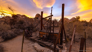
Before long, I'd wrapped up my loop through the Barker Dam area, and it was time for my final short excursion of the day. Only a few hundred feet away, I planned to do only a segment of another - much longer - loop that would take me to Bill Keys old mill, the Wall Street Mill. I'd have to get a move-on though, the sun was getting pretty low in the sky.
While my last hike had been sheltered from what were now sustained 40mph winds, creating a hazy - almost eerie - light when looking towards the sun.Away from the sun, the cloud formations were turning lenticular. Was precipitation on the way?
Luckily for me, the entirety of the out-and-back hike to the Wall Street Mill was a little less than two miles - something I was hopeful that I could get halfway through before the light dropped enough that I couldn't take any photos. As it turned out I was lucky - my timing affording me a striking sky above the mill and not another soul on the ground. Sometimes lightning does strike twice!
On the way to the mill an old ruin with pink walls.A rusting 1929 Lincoln Phaeton in the wash.The windmill at the Desert Queen Well. Excavated in 1908 by William Morgan, the well was drilled 116 feet to reach water for the Desert Queen Mine a few miles east.
Bill Keys played a large role in the development of the Joshua Tree region. One of the more infamous stories involves a gunfight between Keys and a man named Worth Bagley.
A retired lawman, Worth Bagley moved into a nearby homestead in the late 1930s. An argument developed over access to water produced at the Wall Street Well, part of Keys Wall Street Mill mining operation. After some time, a few of Keys’ cattle were mysteriously shot and Bagley reportedly became obsessed with murdering Keys over access to the water.
The well in question.
In May 1943, Bagley placed a hand-written, cardboard sign, “KEYS, THIS IS MY LAST WARNING. STAY OFF MY PROPERTY,” squarely in the middle of a road that Bill Keys had driven on thousands of times in the preceding three decades. As Keys surveyed the sign, he caught sight of Bagley, charging down the hill with a gun in his hand. Suddenly Bagley, began shooting.
When it was over, Bagley lay dead.
Worth Bagley's stone.
Having defended himself against the agitated and mentally ill Bagley, Keys dutifully turned himself in to the local authorities, only to suffer an unjust trial and a lifetime sentence at San Quentin.
For 12 years, Keys and his wife fought to clear his name. Eventually, after engaging the help of Erle Stanley Gardner (a lawyer, and the man that created the Perry Mason stories) who published the story in Argosy Magazine, Governor Goodwin Knight granted Keys a full and unconditional pardon.
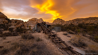
A river of gold in the sky as I approached the Wall Street Mill.Rail used to load ore into the two-stamp Wall Street Mill.A custom gold mill acquired and operated by Keys, gold was processed in batches for local mines in the area, and Keys would keep a small percentage of the returns.Interestingly, there was never a mine at the location of the Wall Street Mill.Another of Keys' converted ore haulers.
Thrilled to have made it to the mill with just enough light to poke around for a few minutes - not to mention having the place to myself - I headed back to the Tacoma and a wonderfully empty parking lot. A combination of wind, time of day, and warning that anyone parked here after sunset would receive a $180 ticket were likely contributing factors to the lack of other vehicles.
Time to head to camp.
With my camp site less than 5 minutes away, I was soon pointed into the wind and doing my best to keep the burners on the Coleman camp stove running long enough to cook dinner. I knew - as I wolfed down the taco-rittoes - that this was going to be an interesting night. With a forecast of 75mph gusts and sustained winds of 50mph, waves of sand were already being blown through camp.
As the light left the sky, I knew there was no way I would be setting up the tent.
It would be an interesting night to say the least. One where sleep was not my primary concern...
Another fine adventure appreciated all the more because I doubt we'll be going to Joshua Tree anytime soon. Everyone has told me it's like the desert version of Yosemite, long lines of people and full campgrounds. I do think we'll be going to Anza-Borrego though and a few other places that you've mentioned. As for Joshua Trees, we have tons of them here in the Antelope Valley as neighbors!
turbodbApril 13, 2023
Thanks John, glad you enjoyed it. It's a funny thing - I've referred to it the same way in relating the experience to some of my family and friends. For sure, it's not actually as crowded as Yosemite or some of the other more popular National Parks (Zion, etc.), but it definitely has a different feel than Death Valley or Canyonlands.
The nice thing about Joshua Tree is that the mid- to longer-hikes are still reasonably unpacked, so it is still possible to get out into the desert alone.
Anza is great too; I'd love to get back there for some more exploration!
Lapsley HopeApril 13, 2023
I really enjoyed this 'episode'. Full of interesting and fascinating history, and illustrated with your fine photography, makes it even more involving and pleasurable. I suspect that John Samuelson was not quite as 'insane' as he was declared to be.
On a side note, I discovered that in 2020 a high school friend of mine nearly died while hiking in Joshua tree. Seems he had a fall and suffered a broken femur, but managed to survive on limited water and berries until he was rescued. His ordeal made national news but at the time I realized that of all my friends from high school, he would have been the one to have the skills to survive.
turbodbApril 13, 2023
So glad you enjoyed it Lapsley ?. I suspect that Samuelson might haven't had quite all his marbles, but perhaps the ones missing were not the ones he went to trial for. Certainly, whatever the situation, I think it was too bad that he wasn't able to acquire the homestead due to his heritage.
That's quite the story about your high school friend. A good reminder that we should always let folks know where we are going and when we expect to be back. And - importantly - what they should do (and when) if we don't return. Last year I added a satellite communicator to my arsenal, which I hope to never have to use for an emergency. Still, it allows for some preset messages, which makes my family feel a lot more comfortable when I'm out alone.
Lapsley HopeApril 13, 2023
Yes, in fact in the articles published about his ordeal he credits the fact that he always lets his son know where he is going and when he will be back. He didn't have cell phone coverage so when he didn't show up at the designated time of return, his son reported him missing. Apparently he was in a remote section of Joshua Tree park and a SAR team located him. He had run out of water (he went 40 hours before being rescued, in the heat of the summer there). You can find his story just by googling "Injured hiker (Bob Ringo) rescued in Joshua Tree National Park". He was 67 at the time of the rescue.
I will probably invest in a satellite communicator in the future. I always travel alone (with my dog) and into remote locations, so at 71 I probably should be safe rather than sorry.
jane doeApril 13, 2023
I did some of those hikes in January. Also toured the Keys Ranch with a ranger - not worth the time, wouldn't recommend.
turbodbApril 13, 2023
Ahh, interesting. I didn't do Keys Ranch, but I was wondering if I should do it "next time." Probably, it's pretty well "modernized" for safey and doesn't really give you the opportunity to wander and discover things for yourself; is that what you ran into?
Greg von BuchauApril 13, 2023
The last set of photos in this article are stunning. Great light.
turbodbApril 13, 2023
Thanks! Was pretty cool to have the sun streaming in under the clouds on the horizon. I have to say, despite the fantastic colors in the final series, and the coolness of the "river of gold" that the cloud formations made, my favorite was actually the hazy mountains. I really liked the layering in that one.
KennyApril 14, 2023
Thanks for the walk into the past as my wife and I use to camp and explore there in the early 70's, camping in the back of a Toyota pickup with a full size mattress and a GSD with us.
Excellent photos again!
turbodbApril 14, 2023
Thanks Kenny, glad I could take you back! I bet it was a whole lot less crowded in the 70's. Shoot, probably wasn't even talk of making it a National Park yet!
Philippe RichenApril 14, 2023
Excellent sided stories of the people in the past. I drove by Joshua Tree during a trip from California to Florida as it was snowing. I had to push on at the time and really regret not having stopped & explored. The images in this particular post has lead me to the conclusion that somehow I will have to find my way back there one day. Thanks!
DarleneApril 14, 2023
I can see why you've held off going to Joshua Tree when you'd been at Death Valley. It's 228 miles and almost 4 hours. For me it's a straight shot (kind of) from Colorado. I would always go to Joshua Tree when I went to Death Valley. The comments are quite interesting. I have never experienced long lines and crowds at either place, except for Skull Rock in Joshua Tree and Badwater Basin in Death Valley. I don't like too many people in my photos so for Skull Rock I went back at 6 am. I like to dry camp/car camp, but Joshua Tree prohibits that on their back country roads. I like to stay at the BLM overflow camping just outside the southern entrance. It's not far from I-10, but quiet. And what might be boring for one personal isn't always true for another.
Your posts always challenge me to do research. So when you mentioned signs at an area outside of Joshua Tree, I had to find out why. It's land around Coyote Hole that has been protected by The Native American Land Conservancy. They've also signed an agreement of co-stewardship with the park for administration of Coyote Hole. It makes sense they would want to give permission for people to visit in order to prevent vandalism and destruction.
Did you know there are two species of Joshua Tree - the ones in Joshua Tree NP and the ones in Mojave National Preserve? They have very distinct characteristics that separates them physically and botanically.
Thank you for another good adventure. You are traveling the back roads I probably wouldn't try. You are definitely more experienced.
turbodbApril 14, 2023
Hi Darlene - glad you enjoyed the story; it's always so nice to hear!
I noticed that BLM area near the south entrance of JTNP, and while I didn't stay there exactly, the next part of the story does have me setting up along the parks southern boundary. (stay tuned ?)
I had no idea about the two types of Joshua Trees, and I find it fascinating that they differ - I'll have to go look that up more for myself so I can better understand the differences, and perhaps try to notice them in person the next time I visit.
Of course, the Joshua Trees I have the most familiarity with are those in Death Valley. Do you know if those are more similar to Mojave or JTNP? I'd assume Mojave given the proximity, but nature can be weird sometimes!
DarleneApril 15, 2023
I can't wait until your next installment, and sometimes I can't wait until the end to comment.
I'll try not to write a long treatise. The major difference I've noticed between the two Joshua trees is in the trunks. The trees in DVNP are more similar to the ones in JTNP. The trees, more like a bush in MNP, are a separate species, shorter in height, longer leaves, pollinated by a different moth. Mojave has the largest concentration near Cima Dome. A recent fire devastated the forest there and volunteers have been planting new "trees". The Mojave land trust calls the trees in the preserve Mojave Yucca. The largest concentration in DVNP is in Saline Valley. Then there's the Eastern and the Western Joshua trees. Can it get any more confusing? I encourage you look up more information, they are most interesting.
All Joshua trees are yuccas but not all yuccas are Joshua trees. Yuccas are succulents, but not cactus. And darn it, the JTNP Joshuas look like trees, but aren't.
JTNP is also supposed to be full of vortexes. I've never felt one, not there or in Sedona, AZ. I guess I suck at feeling the energy. I'm already energized enough just being in the desert.
I stopped by the Cottonwood visitor center once and asked about growing Joshua Trees outside of southern California. He showed me a picture of one in British Columbia, in the snow. You can buy the seeds but I haven't attempted to grow one.
turbodbApril 15, 2023
I always welcome long treatise. Goodness knows, I can be longwinded myself.
I'll definitely need to inspect the JTs more closely next time, as I've not noticed the difference, despite several trips to the parks. Also, since you mentioned Cima Dome, I'll add a couple additional details:
Speaking of volunteers planting trees - I give you, "turbodb" ?
DarleneApril 15, 2023
Is that you? Cool. I have yet to comment on your entire trip, I think I missed a couple of episodes. I looked at the application for volunteering. I could do that and wondered if I could get away that time of the year. I'd like to go back to Mojave this year, I usually travel in the summer. I'll definitely look for your tree.
Matthew MangusApril 18, 2023
Another great story. If you enjoyed the rock formations in Joshua Tree, you really should get down to the Catavina area of Baja. It's fantastic.
turbodbApril 23, 2023
Thanks! Sort of a slow reply on this one as I just got back from several days down in SE Utah hiking and searching for rock art and ruins. Nice to get out of CA for a change!
I've never been to Baja, but it's definitely on the todo list. Thanks for the recommendation on Catavina, I've added it to the "planning list" for that trip (really just a list of places in Baja that folks have suggested)!


Another fine adventure appreciated all the more because I doubt we'll be going to Joshua Tree anytime soon. Everyone has told me it's like the desert version of Yosemite, long lines of people and full campgrounds. I do think we'll be going to Anza-Borrego though and a few other places that you've mentioned. As for Joshua Trees, we have tons of them here in the Antelope Valley as neighbors!
Thanks John, glad you enjoyed it. It's a funny thing - I've referred to it the same way in relating the experience to some of my family and friends. For sure, it's not actually as crowded as Yosemite or some of the other more popular National Parks (Zion, etc.), but it definitely has a different feel than Death Valley or Canyonlands.
The nice thing about Joshua Tree is that the mid- to longer-hikes are still reasonably unpacked, so it is still possible to get out into the desert alone.
Anza is great too; I'd love to get back there for some more exploration!
I really enjoyed this 'episode'. Full of interesting and fascinating history, and illustrated with your fine photography, makes it even more involving and pleasurable. I suspect that John Samuelson was not quite as 'insane' as he was declared to be.
On a side note, I discovered that in 2020 a high school friend of mine nearly died while hiking in Joshua tree. Seems he had a fall and suffered a broken femur, but managed to survive on limited water and berries until he was rescued. His ordeal made national news but at the time I realized that of all my friends from high school, he would have been the one to have the skills to survive.
So glad you enjoyed it Lapsley ?. I suspect that Samuelson might haven't had quite all his marbles, but perhaps the ones missing were not the ones he went to trial for. Certainly, whatever the situation, I think it was too bad that he wasn't able to acquire the homestead due to his heritage.
That's quite the story about your high school friend. A good reminder that we should always let folks know where we are going and when we expect to be back. And - importantly - what they should do (and when) if we don't return. Last year I added a satellite communicator to my arsenal, which I hope to never have to use for an emergency. Still, it allows for some preset messages, which makes my family feel a lot more comfortable when I'm out alone.
Yes, in fact in the articles published about his ordeal he credits the fact that he always lets his son know where he is going and when he will be back. He didn't have cell phone coverage so when he didn't show up at the designated time of return, his son reported him missing. Apparently he was in a remote section of Joshua Tree park and a SAR team located him. He had run out of water (he went 40 hours before being rescued, in the heat of the summer there). You can find his story just by googling "Injured hiker (Bob Ringo) rescued in Joshua Tree National Park". He was 67 at the time of the rescue.
I will probably invest in a satellite communicator in the future. I always travel alone (with my dog) and into remote locations, so at 71 I probably should be safe rather than sorry.
I did some of those hikes in January. Also toured the Keys Ranch with a ranger - not worth the time, wouldn't recommend.
Ahh, interesting. I didn't do Keys Ranch, but I was wondering if I should do it "next time." Probably, it's pretty well "modernized" for safey and doesn't really give you the opportunity to wander and discover things for yourself; is that what you ran into?
The last set of photos in this article are stunning. Great light.
Thanks! Was pretty cool to have the sun streaming in under the clouds on the horizon. I have to say, despite the fantastic colors in the final series, and the coolness of the "river of gold" that the cloud formations made, my favorite was actually the hazy mountains. I really liked the layering in that one.
Thanks for the walk into the past as my wife and I use to camp and explore there in the early 70's, camping in the back of a Toyota pickup with a full size mattress and a GSD with us.
Excellent photos again!
Thanks Kenny, glad I could take you back! I bet it was a whole lot less crowded in the 70's. Shoot, probably wasn't even talk of making it a National Park yet!
Excellent sided stories of the people in the past. I drove by Joshua Tree during a trip from California to Florida as it was snowing. I had to push on at the time and really regret not having stopped & explored. The images in this particular post has lead me to the conclusion that somehow I will have to find my way back there one day. Thanks!
I can see why you've held off going to Joshua Tree when you'd been at Death Valley. It's 228 miles and almost 4 hours. For me it's a straight shot (kind of) from Colorado. I would always go to Joshua Tree when I went to Death Valley. The comments are quite interesting. I have never experienced long lines and crowds at either place, except for Skull Rock in Joshua Tree and Badwater Basin in Death Valley. I don't like too many people in my photos so for Skull Rock I went back at 6 am. I like to dry camp/car camp, but Joshua Tree prohibits that on their back country roads. I like to stay at the BLM overflow camping just outside the southern entrance. It's not far from I-10, but quiet. And what might be boring for one personal isn't always true for another.
Your posts always challenge me to do research. So when you mentioned signs at an area outside of Joshua Tree, I had to find out why. It's land around Coyote Hole that has been protected by The Native American Land Conservancy. They've also signed an agreement of co-stewardship with the park for administration of Coyote Hole. It makes sense they would want to give permission for people to visit in order to prevent vandalism and destruction.
Did you know there are two species of Joshua Tree - the ones in Joshua Tree NP and the ones in Mojave National Preserve? They have very distinct characteristics that separates them physically and botanically.
Thank you for another good adventure. You are traveling the back roads I probably wouldn't try. You are definitely more experienced.
Hi Darlene - glad you enjoyed the story; it's always so nice to hear!
I noticed that BLM area near the south entrance of JTNP, and while I didn't stay there exactly, the next part of the story does have me setting up along the parks southern boundary. (stay tuned ?)
I had no idea about the two types of Joshua Trees, and I find it fascinating that they differ - I'll have to go look that up more for myself so I can better understand the differences, and perhaps try to notice them in person the next time I visit.
Of course, the Joshua Trees I have the most familiarity with are those in Death Valley. Do you know if those are more similar to Mojave or JTNP? I'd assume Mojave given the proximity, but nature can be weird sometimes!
I can't wait until your next installment, and sometimes I can't wait until the end to comment.
I'll try not to write a long treatise. The major difference I've noticed between the two Joshua trees is in the trunks. The trees in DVNP are more similar to the ones in JTNP. The trees, more like a bush in MNP, are a separate species, shorter in height, longer leaves, pollinated by a different moth. Mojave has the largest concentration near Cima Dome. A recent fire devastated the forest there and volunteers have been planting new "trees". The Mojave land trust calls the trees in the preserve Mojave Yucca. The largest concentration in DVNP is in Saline Valley. Then there's the Eastern and the Western Joshua trees. Can it get any more confusing? I encourage you look up more information, they are most interesting.
All Joshua trees are yuccas but not all yuccas are Joshua trees. Yuccas are succulents, but not cactus. And darn it, the JTNP Joshuas look like trees, but aren't.
JTNP is also supposed to be full of vortexes. I've never felt one, not there or in Sedona, AZ. I guess I suck at feeling the energy. I'm already energized enough just being in the desert.
I stopped by the Cottonwood visitor center once and asked about growing Joshua Trees outside of southern California. He showed me a picture of one in British Columbia, in the snow. You can buy the seeds but I haven't attempted to grow one.
I always welcome long treatise. Goodness knows, I can be longwinded myself.
I'll definitely need to inspect the JTs more closely next time, as I've not noticed the difference, despite several trips to the parks. Also, since you mentioned Cima Dome, I'll add a couple additional details:
Is that you? Cool. I have yet to comment on your entire trip, I think I missed a couple of episodes. I looked at the application for volunteering. I could do that and wondered if I could get away that time of the year. I'd like to go back to Mojave this year, I usually travel in the summer. I'll definitely look for your tree.
Another great story. If you enjoyed the rock formations in Joshua Tree, you really should get down to the Catavina area of Baja. It's fantastic.
Thanks! Sort of a slow reply on this one as I just got back from several days down in SE Utah hiking and searching for rock art and ruins. Nice to get out of CA for a change!
I've never been to Baja, but it's definitely on the todo list. Thanks for the recommendation on Catavina, I've added it to the "planning list" for that trip (really just a list of places in Baja that folks have suggested)!