
More and more I've found that I enjoy hiking - more than driving - in Death Valley. Getting out into a canyon, walking across the desert, hiking up a sand dune - these are the times when I really find joy in the beauty of this grand place.
And so, for the fifth time in two months, I'm headed back. The plan this time is to hike for three days, to three very special places. These are places that not many people visit, and that I'll do my best to keep a little more obscured than normal.
Oh, and of course, no trip would be complete without a little "excitement" in the motorized vehicle department... but now I'm getting ahead of myself as usual.
I have organized this story a bit differently than most.
Some of the locations have little or no reporting on the internet and I feel they should remain that way or someone I respect has personally requested that I not share them; as such, locations have been redacted and/or not mentioned, I've used non-official names for local landmarks, and the order of the trip has been randomized.
Please, if you know the locations shown here, I encourage you to enjoy them as much as I did - and follow my lead by not mentioning their names or locations in order to keep them a little less well-known, and special.
For more on my approach, you can read Do you have a GPX for that?.
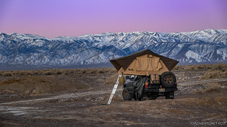
The trip started off like so many others - a long drive south. Having left at 3:30am, I figured that I'd get to Walker Lake - just north of Hawthorne, NV - just after dinner time, where I'd get a good night's sleep and head out at sunrise - for two more hours of driving and a completely new (to me) entrance into Eureka Valley. However, as I neared my destination, I happened to be chatting with my dad on the phone and he suggested an alternate camp location: █████████ Hot Well - a hot spring that he and my uncle had visited a few times. "It's a pretty nice one," he said, "I like it because there are lots of birds there." (Of course!)
Getting a bit more info from him, it turned out to be on my route and only a few miles from my entrance to the park. Given that it was still relatively early, I pushed on, pulling into camp and deploying the tent just before 9:00pm. It'd been a long day and I was pooped, but on the plus side, I appeared to be the only one at the springs - a situation that I could tell from the size of the parking area, was not common.
It was a cold night - temperatures dipping into the high teens - but I slept warmly under my comforters, my alarm set for just before sunrise.

Such a peaceful calm when I awoke.
I can't say that the snow on the mountains gave me the warmest of fuzzy feelings. I'd have to cross some mountains to reach Eureka Valley... at least via my planned route.
Now with a bit of daylight, and as I waited for the sun to crest the horizon, I gave the springs a bit of a look-around. It was definitely a nice place - the soaking area consisting of a clean, concrete pool in front of a couple of large, warm ponds where waterfowl were paddling to and fro.

Well, that sign is a bit ominous.
(He says as he looks over his shoulder to make sure he's the only one around.)

Nicely developed and a reasonably warm 101°F.

Happy ducks under the fiery glow of sun on the snow of the White Mountain to the west.
After a few photos, it was cold enough that my previously-almost-full camera battery died and I headed back to the truck to put away camp. A nice layer of dew-turned-ice on the entire outside of the tent made this a crunchy undertaking. Not only did I get to put the tent away wet, but by the end I wasn't sure if I had any fingers on my hands. Yay, me!

Amazing how just a few minutes can change the light so dramatically in the morning!
And with that, I was off! Still headed south, I decided planned to head into Eureka Valley via Cucomungo Canyon, a new-to-me route that travels in a slightly east-west direction. This would, hopefully, put the sun - at least partially - to my back.

On the plus side, the sun isn't in my face. There is, however, a little issue of white powder everywhere...
Doing my best to ignore the obvious issue of snow before I'd even climbed in elevation at all, I have to say that the Cucomungo Canyon Road is full of interesting tidbits of history. Over the first couple of miles, I ran into the remains of more than half a dozen cabins, mills, vehicles, and other mining relics. As much as I wanted to push on, I couldn't help but to stop at each of them for a look around.
Today, these locations are all on private property; be respectful - as you should be with ANY historical site - if you stop at them.

The Pigeon Spring Mill - once also the site of a saloon, store, and roadhouse.

Nearby, an old dump truck had seen better days.

The mill at the Midway Placer Mine - a tattered flag still flying atop the pole.
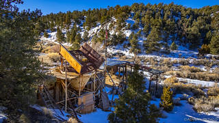
A screen deck and separator at the Midway Placer Mine.
I think I travelled a sum total of about five miles before I realized that I for the last quarter mile, I was no longer on my planned route. Strange, I thought - given that I'd not seen any other clear roads as I'd wound my way up into the mountains. Of course, that's because the route into the park was covered in snow!

Impassable at 6500', the road topped out at 6800'.
Making my way a quarter mile through the crusty-on-top-but-super-soft-underneath snow, I soon decided that the smart move was to find a different way into the park - no need to slip off the side of the road and down the hillside before I even reached my destination!
And so, a bit deflated, I backtracked some 50 miles to North Eureka Valley Road. This is a route I've taken into - and out of - Eureka Valley several times, and I knew that it topped out at 5500' or so, well below the snow line.
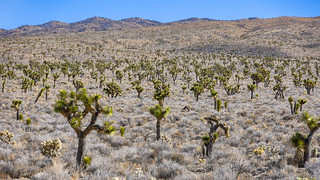
As I sped through the Joshua Tree forest along North Eureka Valley Road, I resigned myself to run Cucomungo Canyon at a later time.
If there's one thing you should know about me, it's that I'm stubborn. Even as I tried to put my disappointment behind me, I watched as the intersection of Cucomungo Canyon and North Eureka Valley Road got closer and closer on my GPS. Before I knew it, I was at the intersection and I had a decision to make - I could be an adult about this and just keep going, or I could waste time and fuel heading up a road I knew to be impassable, just to see how much of it was blocked by snow.
Adulting be damned! Heading up into Cucomungo Canyon.
Ultimately, I ran into impassable snow at a point two miles from where I'd turned around on the way in - a distance that would have been slow and treacherous at the very least, and trip-ending at the worst. Turning around, I headed back toward my destination - happy for my decisions, even if I was two hours behind schedule at this point.

The second Death Valley trip in a row where Winter got in the way! Isn't this place supposed to be hot?

Even if I'd wasted time, driving down through Cucomungo Canyon was a beautiful experience, so I was glad to have done it.

This splash of color - where I rejoined North Eureka Valley Road - always elicits audible admiration from me.

Anticipation. Just around that corner, I know Eureka Valley is going to dazz...
A nice thing about Eureka Valley is that most of the roads allow for reasonably fast travel - at least in the right vehicle. Mine happens to be such a vehicle, and I made quick work of the 15 miles between me and the spectacularly dramatic Eureka Dunes. These - the first dunes I ever climbed in the park (on our In Search of Overlooks trip in 2019) - have always held a special place in my heart, and I couldn't help but stop several times along the way to capture them as they filled more and more of my view.
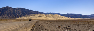
Hello old friends.

Oh, how deceptively climbable those ridges look. Surely it can't be more than 10 minutes to the top.
It was as I was snapping that last photo that I glanced further up the road and noticed a white Ford F150 coming the opposite direction - or at least, I thought it was coming the opposite direction. After taking a few pictures, I realized that it wasn't actually moving, and that there appeared to be dust being kicked up from spinning tires as the driver attempted to free themselves from an unfortunate situation.
I knew exactly what was going on.
This, you see, is a several-hundred-foot-long section of road that is a disaster. As if deep sand wasn't treacherous enough, this is a place where the sand has been completely displaced by the finest, lightest, fluffiest dust you've ever seen. The wrong line, not enough momentum, or ground clearance that is just a little too low can all spell trouble. And if you get stuck, well, you'll be swimming in it.
Swimming is the best way I can describe the scene I pulled up on. Laid out on his belly, his shovel extended under his truck in a futile attempt to clear the liquid silt, █████ noticed me only after I'd come to a complete stop, just at the edge of the pit. The entirety of his being was a monochromatic yellow.
"Want me to pull you out?" I asked, a big smile on my face - the question more rhetorical, and really just my way of saying hello.
The relief I saw spread over ██████ face was palpable. He was, I could tell, unaccustomed to the situation in which he found himself - the recipient of assistance rather than the giver of such. Walking over to my position on the side of the pit, I recognized his comfortable - if a bit sheepish at the moment - stride as my own. Within seconds, our introductions turned to conversation, each of us sharing our recent experiences in this vast wilderness we both loved, the rescue of his truck a foregone conclusion before we'd even begun.

Pulling from the side seemed to be the quickest way out of the dust river.

Out we go.
Turns out that █████ had been trying to free himself for 4½ hours before I'd shown up - a period of time I can hardly fathom wading around in that mess. Hauling rocks, placing boards, and scooping out one shovel full of dust at a time, I'm sure he'd have freed himself within moments of my appearance - but less than 10 minutes after pulling up on the scene, a little tug from the Tacoma was all we needed to get him onto much firmer footing.
Smiles - which had been a constant from the beginning - grew larger. As though we'd known each other for years, the easy conversation alternated between more talk of desert experiences and the usual thanks and deprecating reassurance that it was no big deal. Helping in situations like this is just part of the adventure, and something we all do for each other, building up karma for the inevitable rescue that we'll undoubtedly need in the future.
After another ten minutes, I realized that I was consciously going to have to pull myself away - to not do so would result in my staying to chat all day with a future version of myself! And so, to continued thanks, I bid █████ farewell and a safe trip home as I continued on my way, thinking only after I turned around a half mile later that I ought to give him my contact info so we could continue our conversation later!
Departing for a second time, I was soon climbing out of the valley and away from the dunes as I approached the narrow track through Dedeckera Canyon - one of my favorite stretches of road, and one that I've traversed several times in the past.

Starting up through the first of three obstacles.

Tough tires and a good line are the most important factors to success on this part of the trail - as is the case with so many trails.

Up we go.
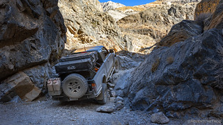
Lots of stacked rocks from previous attempts made the trail as easy as I've ever seen it.
As I climbed through the canyon, I found myself extremely cognisant of the time, for several reasons. The first was that I still had much planned for the day - with quite a bit of driving and hiking still to come. Even more importantly however, I found myself hoping that I'd catch a plane or two streaking through the canyon once I was clear of its upper end. I've found that there are often several of these passes each day, but that they tend to take a break for lunch, and as it was getting on 1:30pm, I was sure that it wouldn't be long before I heard a roar overhead.
And so, as I exited the canyon and the landscape of Steel Pass opened up before me, I pulled to the side of the road and ate breakfast. Or lunch. Or an early afternoon snack. Whatever it was, I consumed it slowly, my hopes high. And then I putzed around a bit. Still, nothing!
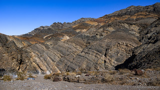
I've never hiked any of Dedeckera's side canyons, but the geology here sure makes them look enticing.

With a view all the way down to Eureka Valley, I was hoping to see a mechanical bird banking its way toward my position.
Eventually, I could procrastinate no longer and I continued on - too much adventure ahead to wait in hope for something that may never happen.
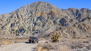
Between Dedeckera Canyon and the northern end of Saline Valley, a vast high-desert plain gives Steel Pass an understated beauty. Dotted with Joshua Trees, the road here is a pleasure to drive, allowing for high speeds and full cycling of the suspension. I took full advantage to make up a bit of time.

Even the Tacoma didn't escape the Eureka Valley silt unscathed.

A young Joshua Tree, impersonating a yucca.

Even in the desert, there are splashes of green if you know where to look.

I think the Joshua Tree wore the view to Saline Valley better.
As with Dedeckera Canyon, I covered the route through Steel Pass - and into Saline Valley - in record time, the rough road where I've previously lost skid plate bolts and carefully picked my way through tight turns with large rocks, gliding uneventfully blow my tires.

Poser. 
Along the way, I was disappointed to discover that an old road - one that's been signed as closed for years - had been heavily travelled over the last year. Pulling over, the problem was quickly evident - disrespectful humans had destroyed the closure sign. This sort of thing really pisses me off, and I spent the next 15 minutes trying to put things back together again.

It's disrespect like this that make me wonder how much longer we'll be able to enjoy our public lands the way we do today.

Hopefully the NPS can get out to repair this the right way, reasonably quickly.

Further along in my descent into Saline Valley.
Ultimately, for the next three days, I'd enjoy myself immensely. Desert hiking was the main attraction, but I didn't complain at all about the fabulous fighters overhead! In fact, I encountered my very first pair of A-10's, which I was so excited about that I couldn't even hold the darn camera steady as I filmed them roaring above.
Iron Eagles soaring over Saline Valley.
I'd also find myself camped in various locations around a valley primarily known for the warm springs it contains. I'd never spend any real time at the springs, the hundreds of vehicles I could see arriving - at all hours of the day - enough to keep me in my more solitary camps and canyons.

The golden glow of late afternoon.

A fiery sunset.

My own little slice of paradise.

Sunrise over the landscape.

Mornings were no less dramatic than evenings.
I'd see only one other person in my time roaming Saline Valley - and even then, only because I'd been expecting them. That though, is another story - one that must wait until after I finished Hiking Saline Valley, alone.
The Whole Story


Once again you've hit an in the park home run, pun intended! Thanks for taking the time and effort to chronicle your explorations.
You're welcome Ralph! Always nice when folks like you enjoy the stories! Can't wait to get back out there... as always, hahaha!
I look forward to these trip reports quite a bit! Thanks.
As a photography guy as well who enjoys the images as much as the story, just wondering if you're using bracketing for exposure and focus or both?
That's cool to hear Joe, glad I can get another one started for you to enjoy.
For the photos, I generally don't bracket at all; I mostly shoot with aperture priority, and -1EV, which I find I can usually recover details in the shadow areas pretty well without blowing out the highlights. If I do bracket - maybe 1-2 photos per trip - it's only for exposure, as I've never really figured out how to do it for focus. (he says, a bit timidly)
I tried to outline my process a bit here: If You Take Enough Photos, Some Are Bound to be Decent which you're welcome to peruse.
I'm not using that specific camera anymore - you can see the updates at the bottom of the post - but all the shooting and processing techniques remain the same. I actually just saw a few videos about ETTR (expose to the right), which is exactly the opposite of what I do, so I may try playing around with that a bit in the future.
I'm a photographer, and I think your editing is about perfect! I sure am enjoying exploring more of Death Valley through your posts!
Thanks Kim! I'm glad you're enjoying the posts and photos. ? There's lots of Death Valley to explore, and I've only gotten the tip of the iceberg!
Beautiful stuff!
I always enjoy traveling with you....
Thanks again!
And I appreciate your comments about keeping our deserts and parks pristine.
David
You're welcome David. This particular part of the story didn't have any places that I really had to redact, but the rest of the trip has many. It's an unfortunate reality in this day and age, I suppose. Still, just knowing those places are out there would be enough to get me off the couch and planning a trip, so hopefully they inspire others to do some route planning as well!
Another envy worthy adventure that’s sparked the imagination of those who dream of one day exploring Americas public lands…
Thank You for not disclosing the location of these historical sites. It’s truly heartbreaking to revisit various locations only to see some of the graffiti and destruction left behind…
Happy to hear you enjoyed the adventure Louis! I always try to keep places that aren't well known from becoming too overrun. Once it gets out there on the internet, it's out there forever! Still, I think it's important to share the special places - through stories and photos - so that others know what they could find if they just got up from their screens and set off adventuring! Cheers!
Looks like a great trip! Been through those areas myself. Even drove the girlfriend's Camry on the dirt road from Pigeon Springs to Gold Point...Immediately looked for a lift kit for it online when I got home ha ha. Nice to see that you made a successful extraction!
Was a fun start to the trip for sure Jim. The really great part for me was the hiking over the next few days. I just posted the first of those days (In Search of Grand Views - Hiking #2) if you're interested in checking it out. No trucks in that story, but an amazing canyon and arch!
I didn't realized that Pigeon Spring to Gold Point was doable on dirt - that sounds like a fun route (though perhaps not in a stock Camry! ?). I'll have to give that a bit of research, because I thought Gold Point was pretty cool when we went through there on the Nevada Backcountry Discovery Route. ?