
Ever since our first visit to the Owyhee, the high desert of southeast Oregon has delivered trip after trip full of wonderful discoveries and surprises. Still - all these years later and having visited nearly a dozen times - I'm sure we've only scratched the surface. In fact, while we did once find a dirt route between Fields Station and the Hart Mountain National Antelope Refuge, we've rarely explored west of Steens Mountain at the edge of the Alvord Desert.
And so, finally, it's time. Having uncovered a few interesting destinations near Hart Mountain over the last couple of years - and hoping to visit before snow covered the region for the winter - it seemed like this was the perfect time to visit some abandoned homesteads, old mines, and World War II plane crashes.
We got started as we always do - heading south. Stopping just outside of Portland for lunch, @mrs.turbodb commented nonchalantly that the building near the taco truck where we'd stopped seemed to be on fire.
"It's just steam from the heaters," I assured her, as we ordered our burritos.

It was not steam.

"Waves" on fire. Irony, thick.
The entertainment - though, I suppose that designation probably depends heavily on one's relation to the laundry - was wrapping up just as we finished eating our burritos, and the rest of the trip south was relatively uneventful.
Actually, that's not entirely true. Thirty minutes after lunch, we started hearing a strange noise coming from the Tacoma. Initially I thought it could be a bearing in the transfer case going out again - it seemed to have a similar sound to what happened when I'd had trouble earlier - but then we noticed that it varied with engine speed rather than wheel speed. Perhaps a bearing in the alternator or power steering pump.
At any rate, I pulled over a few miles later at an O'Reilly. The noise was definitely coming from passenger side of the engine bay, and seemed to be the power steering pump, A/C compressor, or A/C idler pulley. None of the pullies were hot to the touch however, so bearings weren't looking to be the culprit. Checking the power steering reservoir, the fluid level - at this point, hot - was well below the "cold" mark, so I poured in a bunch more ATF, expertly spilling it all over that portion of the engine as I did so.

Hope this works.
Relieved - and also surprised - that the noise disappeared almost immediately, I pushed the question of "where did my power steering fluid go?" out of my mind as we continued on. Note: even on our return, I can't find a leak anywhere, and I just recently replaced the steering rack and refilled everything. Mysteries.
As the hours ticked by, we gained elevation. Rain, and then snow fell around us. We looked at each other wondering - would it stop before we got to our destination? Were we crazy? Still, it made for a beautiful drive.

Sky drama.

White blankets.

Into the sunset.
It wasn't all that late when we arrived just outside of Christmas Valley, Oregon - perhaps a little before 7:00pm - where we planned to camp for the night. It was, however, dark, and that made finding our turn a little more... interesting.

The directions we had were to "look for the gate marked by a boot."
In the end, we found our way and by 9:00pm we were climbing into a very cold tent under clearing skies. Snuggled under two down comforters, the insulated Exped Megamat did a great job of warming us up quickly, and before long we were blissfully asleep.
The Following Morning...

It was cold.
With temps this low, I was glad to have stored my camera battery in my pillow case through the night, and after pulling it out for a few minutes to snap a pre-sunrise photo of camp, I quickly climbed back into bed with my warm companion for another several hours until the sun was well above the horizon and the temperatures outside climbed to a balmy 22°F.

We didn't get too near the edge in the dark.
Our plan for the morning was to explore the wreckage of two crashed military planes - a Lockheed P-38 Lightning and a Grumman A-6 Intruder - that had gone down in 1945 and 1973, respectively. And so, armed with a few notes I'd received from the local BLM office on where to find the sites, and an arrow-adorned-carsonite-post pointing in the general direction, we bundled up in our warmest gear and set off on foot.

Not t-shirt weather.

"The P-38 is harder to find. As of August 2021, 3 carsonite signs are spaced out over .80 miles to help point you in the right direction." -BLM
Though there are now only two carsonite markers - one of which we'd camped next to - I eventually spotted the memorial plaque in the distance and soon we were stepping around sagebrush as we wandered from one piece of P-38 wreckage to another.

On February 9, 1945, P-38 Lightning Fighter Pilot 2nd Lieutenant Max P. Clark, age 25, was on a gunnery training flight out of Redmond Army Air Field, Redmond, Oregon, when his plane crashed at this location, killing him. The debris from the crashed P-38 is left here as a tribute and memorial to 2nd Lieutenant Clark who perished while serving his country.
The remains of the plane are a historic site and should not be removed or defaced.
Please respect the memory and sacrifice of Max Clark.

Something shiny.

Something rusty.

One of the larger pieces was adorned with a faded flag.
The P-38 Lightning was one of the U.S. Army Air Force's primary fighter aircraft during World War II, and was the aircraft of America's top fighter aces. It was the only AAF fighter aircraft in production throughout the war, from Pearl Harbor to Victory over Japan Day.
With the P-38 operating in combat theatres around the world, there was a steady demand for replacement pilots to compensate for the fielding of new units, to replace battle losses, as well as allow for the rotation of combat-experienced pilots from the overseas theatres. Portland Army Air Base (PAAB), as it was designated at the time, played an important role in the USAAF's P-38 program, and was responsible for training hundreds of P-38-qualified pilots during late 1944 and early 1945.Lt Col Terrence G. Popravak, Jr., USAF (Retired), 142nd Fighter Wing History Office


An interesting arrangement of fasteners.

A lever.

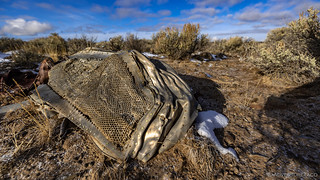
We only found one of the tires.
It was sobering, walking through the debris field, wondering what happened that caused 2nd Lieutenant Clark to crash land in this location. It appeared - from the distribution of wreckage - that he'd been flying southeast to the northwest, perhaps trying to land on top of the plateau after noticing some problem with his plane.
Radiator.
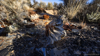
A turbine.

A piston.
Whereas at another crash site we've visited we were able to easily identify engines and other components, nothing at this site - to our untrained eye - was identifiable as a major component of the aircraft, and after 30 minutes or so of searching and reflection, we set off to find a second set of remains. For, just over a mile away, a similar tragedy - this time a Grumman A-6 Intruder - crashed 25 years later.
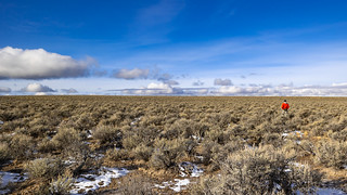
Heading across the desert in the general direction we expected to find the A-6.
The crash site of the A-6 was significantly easier to find. From a distance, the flag-draped tail section of the plane rose up above the sage.

A beacon to those coming to pay their respects.

An A-6, for reference.

On September 19, 1973, A-6 Intruder Pilot Lieutenant Alan G. Koehler, age 27, and Navigator Lieutenant Commander Philip D. duHamel, age 33, were on a low level night training mission out of Whidbey Island Naval Air Station in Washington when their plane crashed at this location, killing both men. The debris of the A-6 is left as a tribute and memorial to Lieutenant Koehler Lieutenant Commander duHamel who perished in the service of their country.
The remains of the plane are a historic site and should not be removed or defaced.
Please respect the memory and sacrifice of these men.
Perhaps due to a difference in construction or to the mechanics of the crash, the A-6 site contained quite a few more recognizable pieces of wreckage. From our observation, the flight path seemed to be east-to-west, and over a length of more than a quarter mile.

A closer look at the tail section and its substructure.

A part of the fuselage, with a portion of the US Navy National Star Insignia.

Some electronic relays.

A portion of the fuselage, with NAVY lettering.

A wing section; ailerons covered in a dusting of snow.

Unknown electronics, and the cockpit housing draped in the stars and stripes.
Apparently, both LT Koehler and Commander duHamel were performing routine training at Boardman Bombing Range 85 miles east of Klamath Falls prior to their crash. Both ejected from the seat envelope too late - once the plane was already on the ground - and were killed. (ejection-history.org.uk - Project Get Out and Walk)

Interior of the cockpit, where pilot and co-pilot sat side-by-side. An American flag adorns the yoke, and a beer has been placed in the location of each airman.

Between the cockpit and tail section, a vast swath of land appeared burned, and was completely devoid of vegetation. Fuel spill and subsequent fire, perhaps.
Having spent significantly longer at this site than we had the P-38, both of us were getting hungry and decided it was time to head back to camp for lunch and to put away the tent, which had been covered in a thick layer of frost when we'd left it a couple hours earlier.
Even as we headed back, a few more bits of the A-6 caught our attention. I suspect that one could spend quite some time wandering these parts and continue to discover artifacts and clues.

A portion of the fuselage with a "Rescue" handle.

The underside of the tail section was quite a distance from the rest of wreckage.
Completing our loop, we were happy to see that the tent was nearly ice-free on our return, the sun and wind causing the frost to sublimate rather than melt. As I set about stowing the tent, @mrs.turbodb put together a couple of - quickly consumed - salami sandwiches, apples, and a special treat: Cheetos!

Back to camp.
And so, just before 12:45pm, we found ourselves dropping down the steep road leading off the plateau and retracing our path across the valley from the night before, seeing it for the first time.

Off the plateau; into the next stage of the adventure.
Of course, as high desert, it seemed there wasn't much to see. And yet, as always seems to be the case... we just had to know where to look.


If you are " west of Steens Mountain" you are not "at the edge of the Alvord Desert", if I read the USGS maps correctly.
I certainly share your fascination with far SE Oregon, which I've been visiting since the late 60s. It's really the only part I visit anymore.
Hey Anthony, what I meant by that was that we haven't explored (much) west of Steens Mountain (which itself is at the edge of the Alvord Desert), not that the Alvord stretches west of Steens. The high desert west of Steens is some "other" desert, which I'd love to learn the name of, if you know. Or perhaps it's not's a named desert, since it's basin and range at that point...
As far as the SE Oregon area, it sounds like you have a lot of experience! I'd love to be the recipient of anything you're willing to share - be it actual places to visit, good books on the area, etc.
Out here in the "High Mojave Desert" it also gets cold, but seldom gets down to 16, when it does I have to take extra measures as the pipes can freeze and once every several years we get snow but right now it's darned windy which is probably worse than the cold or summer heat as sand piles up all over the place. As always, you spin a good tale and I'm psyched up to do a little exploring as soon as my mechanic has time to replace all my shocks and install 3" levelers on the front. Have the rooftop tent and everything else ready for a trip!
Oh yeah, the wind is the thing we always try to avoid as well. It's terrible with the rooftop tent (but probably not as bad with a wedge...if only we had one) and one of the only things that will get us to a sheltered camp site at night rather than a cliff overlooking some fantastic view.
We had one night - in the eastern Mojave near the Bowl of Fire - that was the worst. After suffering through the night, and even with all the doors and windows completely closed, we woke up to lots of sand in tent, and in our hair. No thanks!
Yes, blowing (fine) sand is terrible and it comes in around windows, doors, everywhere. And a few minutes outside in it you get that gritty feeling in your teeth, YUCK! It invades everything, LOL!
Do you know if all 3 crash sites you have been to are legal to go to by way of a SXS or ATV? There is a group of us old duffers that like to explore places like this on one week summer adventures. You tell a great story,
Thanks
Hey Rob, I don't know if these are accessible via ATV/SxS - that's something I am generally blissfully unaware of, given my mode of transportation. They are all on BLM land, so my suggestion would be to give the BLM office there in Lakeview a call to verify one way or the other. I will note that neither site has a legally drivable road (regardless of vehicle type, and please respect the signage/lack of road if you find these places) that goes all the way to the site, so there's some hiking required no matter what.