
All aired up, Mike @Digiratus and I were about to spend the rest of our day on pavement. Well, pavement or its equivalent at any rate, since there are a good many highways - like BC-31 - that are gravel, but are so well groomed that we could easily achieve pavement speeds.
Like the state of Nevada, southeastern British Columbia is comprised of a series of ranges that run north-south, separated by valleys and lakes. And, while the trails we wanted to run - out of the Radium Hot Springs area - were only one range east, and less than 30 miles away as the crow flies, it would take us more than 220 miles of highway and a ferry ride to make our way around.
In the end, this turned out to be a good thing, as it meant that we didn't feel as though we were in any sort of rush - as we may have felt if we were going to try to run another trail once we got there - and it allowed us to enjoy our surroundings as we drove what turned out to be some spectacular highways.

This waterfall looked great from the road, and I was able to slow the shutter just enough to get the wispy flow.

By the time I'd finished snapping a few pics of the waterfall, Mike had caught up to me on BC-31.

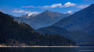
Not much wind and a nearly glassy surface on Trout Lake as we continued north towards the inland ferry at Galena Bay.
We arrived at the Galena Bay ferry loading area just as a ferry was arriving to unload vehicles from the opposite side of Upper Arrow Lake. Though I'd ridden on them before, I was still quite excited for our trip across the lake on the ferry. Plus, I figured, we were far enough back in line that we would be on the next ferry, so I had plenty of time to photograph this one as it came, loaded, and went.

If the line had been shorter, our timing would have been perfect.
As the ferry was unloading, I walked back to our trucks to let Mike know that there was no way we were making it on - an observation he agreed with after counting the load of 47 vehicles as they drove by. Still, we had to move forward as those in front of us boarded, and as we got closer to the front of the line, I found myself wondering - might we make it?!

"We" didn't make it.

Even after letting the ferry worker who was loading vehicles that we were together, I was the last one on.
Known as the Inland Ferry system, there are 14 of these ferries, all of which operate under private contract with the Ministry of Transportation and Infrastructure. Free of charge to users, I highly recommend altering your route to ride on one - or more - because it's such a cool experience. The views can't be beat, either.

The trip to Shelter Bay was about 30 minutes, 27 of which I spent walking around taking photos!
Looking north towards Mt. Darling.
Luckily, Mike and I were able to use our radios to communicate, and though we made separate trips across the lake, he used the time I was crossing - and I used the time he was crossing - to make and eat our lunches. 
Mike showed up right around 2:00pm, and soon I was leading the way to Revelstoke on BC-23. The plan was to fill up with fuel and then continue on our way over Rogers Pass on the Trans-Canada Highway before heading south on BC-95.

Revelstoke seems - to me - to be the Breckenridge of British Columbia.
Getting fuel turned out to be a bit more of an ordeal than we imagined - several stations out of the 91 octane that the Redhead now consumes with a newly installed supercharger. But a Shell station finally came through and after realizing that "expensive" gas in the U.S. was a relative term, we were on our way to Radium Hot Springs.

Having visited Radium Hot Springs before, Mike jumped into the lead for this part of our journey.

Several segments of highway sported avalanche snow sheds - some of which are maintained by the province; others by Parks Canada - this one apparently having done its job. (Jack McDonald Show Shed)
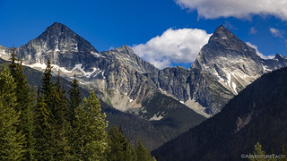
All along the way - but especially through the Rogers Pass area - the views of the mountains were fantastic.
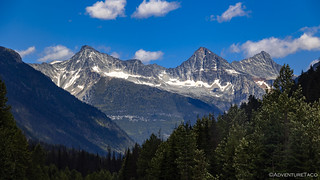
Avalanche Mountain (left), and Eagle Peak (center), and Uto Peak (right).

Avalanche Mountain (left), and Eagle Peak (left-center), and Uto Peak (right-center), and Mt. Sir Donald (right).
As we got closer, Avalanche Mountain, and Eagle Peak really loomed overhead.

Rogers Pass, the melting snow cascading down the cliffs in huge waterfalls.
Tooling along at somewhere between 80-100kph (50-62mph), it was nearly 5:00pm when we rolled into Radium Hot Springs, ready for another drink of gas. We'd had a bit of a tail wind - resulting in 19.37mpg for me and 17.5mpg for Mike - and prices here were nearly 40 cents/gallon cheaper, so it wasn't quite as painful as Revelstoke had been.

As we filled up the Tacomas, I couldn't resist a few shots of the Radium Hot Springs sculpture; the horns of a Bighorn Sheep. They've got you beat, Revelstoke.
Camp wasn't too far out of town, so it was less than half an hour later when we were pulling into a spot at Dogleg Lake. Initially, the site looked promising, but within a couple hours, it would turn out to be my least favorite of the trip. Not because of the location (on a serene glassy lake), or the company (Mike was as pleasant as always), but because of the little mother-sucking vampires that were out in force and swarming in clouds of more than 20 at a time.

On our way to camp; we'd be up in those mountains in less than 24 hours...

How a lake so close to town has only one dude floating around fishing in it is beyond me.
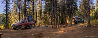
Home for the night.
Almost immediately I had my bug jacket on. I'd hoped - given the still-86°F-temps - that it would be enough; it wasn't. Soon I'd also donned my hooded sweatshirt, hoping that the additional layer of thickness would render the blood suckers harmless. It did - for the most part - with the exception of my back. Pressed against the back of my chair - which I hadn't realized was thin netting - those little bastards were able to stick their vampire straws through the chair, my bug jacket, sweatshirt, and t-shirt, to drink their fill. I only noticed after getting about 5 bites.
Thoroughly pissed off, I ate a quick bowl of cereal for dinner and retired to my tent. It was probably only 7:30pm, but I'd had enough. I hate those little #@$@##%@@ mosquitoes.
The Following Morning...
For all my complaining about the mosquitoes, once I was in the safety of the tent, I did get a good nights sleep - completely uncovered given the warm temperature that persisted through the night. Just another vote of confidence for my CVT Mt. Shasta, though I suspect that any tent with screened windows would protect just as well.
After a quick breakfast and breakdown of camp, we headed back out the way we'd come to run the first of several trails we had for the area. Mike had known of some of these from previous time he'd spent north of the border, and some of them were shared by (Canada) Mike, when we'd thought he'd be joining us for our time in the Kooenays.
The first of these entailed us heading north on Westside Rd to its intersection with Frances Creek Forest Service Rd where we'd turn west. This part of the route was well graded and with Mike leading we made good time. Or at least, Mike made good time, and I loitered in the rear snapping a few pics and stumbling on some wild raspberries.
You can't rush when you find wild raspberries.

I really liked the tall yellow grass as it contrasted with the green trees, gray granite peaks, and blue sky.

I suppose I wasn't the only one stopping for photos.

Yum, yum, yum. #secondbreakfast

Like everywhere else, it was spring here. In August.
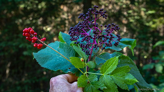
Vibrant berries.
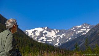
Three quarters of the way up the track we were using, the views opened up and I rounded the corner to see Mike sitting a a picnic table that only had a bench on one side. Turns out, that made a lot of sense, since no one would want to turn their back on the views!
Enjoyment.

The perfect spot for lunch.
At 9:30am - or so - it was still much too early for lunch, but we'd be back here a few hours later to enjoy some sustenance, as I'm sure many before us have done. For now, though, we carried on - curious to see what the remainder of the trail held, given that the "interesting stuff" seemed to be at elevations much higher than it seemed we would reach in the next couple of miles.

At the time, we believed this to be Leadqueen Mountain. It is not.
A few minutes later, Mike radioed back to let me know that he'd taken a fork in the road - to climb the mountain - and was no longer on the track. This was fine by me, as this was just an exploration expedition anyway, and soon we were passing an old cabin as the grade began to increase.

A new, modern cabin is just a few dozen feet away, and appeared to be occupied as we drove by.
A mile or so past the cabin, I came to Mike stopped at a switchback. While we were already well beyond the end of our GPS track, we were coming to the end of the road on Mike's GPS as well, and he figured that this was as good a spot as any to have a quick bathroom break and then flip the trucks around.
Curious, while I was waiting for Mike, I wandered up the next switchback. It got pretty narrow - willows crowding the trail - but it seemed to keep going. I returned to the Tacomas, and had a quick look at my maps. Curiously - as I zoomed in - a road that was invisible at lower resolutions faded into view. I didn't know how far it would go, but it seemed that we could make it at least another mile or so.
Naturally, Mike was game, and given our positions on the trail, he suggested that I lead the way.

After a few more switchbacks and a couple creek crossings, we began to break out of the treeline.
With every turn, the smile on my face grew. Higher and higher we climbed, the views behind us - across Frances Creek - more spectacular by the minute. The trail - as the incline and rock size increased - more and more fun as well.
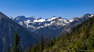
I don't know what these peaks in the Kootenay's are named, but as long as their snow covered peaks were there for the looking, I didn't care a bit!
And then, as the grades leveled out and the road wound through a few stands of high-altitude alpines, we found ourselves in a bowl, surrounded on three sides by vertical granite faces. It was paradise. And to think - we'd almost turned around!

This was *actually* Leadqueen Mountain. Or at least, a bowl below it.

A shallow alpine lake at the signed end of the road. Others have clearly continued up, but this would be the highest we'd get on this adventure.

If only we could camp here.
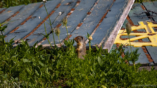
Mr. Prairie Dog was a little grumpy that we interrupted his morning.

We spent half an hour or more soaking in our surroundings - we weren't taking any of it for granite.

The geology up here was so gneiss.
Eventually of course, we had to take our leave. It wasn't yet 11:00am, and as much as I'd have loved to camp here if it'd been a bit later in the day, we had more trails to explore and - hopefully - grand vistas to enjoy. With Mike in the lead again, we got our trucks turned around and rolled ourselves down the mountain.

Woooweee! Love the British Columbia views.
Back at the main road, my newfound zoom level seemed to show our originally mapped trail as continuing on to McLean Lake, and so I suggested to Mike that we should head that way for lunch. As it turned out, the trail continued - but as a hiking trail over a washed-out bridge - so we once again got ourselves turned around and headed back to the picnic-table-with-one-bench for our mid-day meal.

This meander in the creek wasn't doing the remaining road any favors.
After lunch, the next order of business was to check out Forster Creek. This was a route that I'd discovered as part of my route planning by just searching Google Earth for "stuff near the other trails we were already planning," so we had no idea if it was going to be super cool or a total bust. All indications as we made our way up the valley though, were good.

Breaks in the trees exposed some peek-a-boo views.
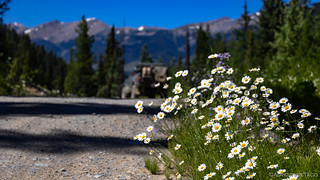
Daisy's!

As we climbed higher, the peaks got a little more rugged.


Cascading waterfalls from glaciers nestled amongst strikingly orange cliffs fed cloudy rivers full of silt.
Sooner than either of us expected, Mike reached the end of the road. As at lunch, the trail continued - but not in a way that our trucks could make the journey. It was 4:00pm, and we'd arrived in camp.

It may not have been the smartest move, but I crossed the unstable bridge as Mike gazed back up at the mountains surrounding camp.

I haven't been to camp this early in quite some time.
With several hours before the sun would set and the campfire would be lit, we set our chairs in the shade and commenced the campfire talk early - each of us yelling to be heard over the roar of Forster Creek. Over the next few hours, I'd go to check on the creek, its level rising nearly two feet in that time - a testament to the hot afternoon temperatures that were beating down on the snow and ice upstream. Mike took the opportunity for a quick wash. And of course, eventually we ate dinner, lit the fire, and ultimately climbed into our tents.
The Following Morning...
I was up early the next morning, and wondered if the deafening white noise would rouse Mike earlier - or keep him in is tent longer - than a normal morning. At any rate, I wanted to see what was beyond the bridge, so after crab-walking my way across the rickety structure, I headed up the trail. Once a logging (?) road, the path seemed to be primarily used by snowmobilers - and to a lesser extent, hikers - in recent years, and afforded some spectacular views of the surrounding ridges.

"Surely I can make it across - a couple times - before the whole thing is carried away."
-Famous Last Words.

A new day is dawning.

I wasn't the only one enjoying the purple daisies.
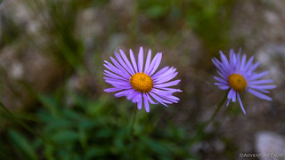
The purple daisies.
Forty minutes later I found my way back across the - still trembling in the rushing river - bridge and found camp still void of my companion. In an unusual twist, I found myself shutting the Tacoma doors a bit more firmly and making breakfast a bit more loudly than usual, trying to overcome the relentless pounding of Forster Creek.

Sun's out, but Mike's not!
Either my ruckus worked or Mike's alarm went off. 
Pretty soon we were headed back down the trail, Mike radioing back that he was following an elk for a good length of time. I'd seen a couple - though quite far away - on my stroll earlier in the morning, so I was happy that he got to see one as well.

A hazy morning as we headed east into the sun.
From Forster Creek, we headed south - this time to Bruce Creek. It was a trail that I'd hoped to connect through to Toby Creek - one valley further south - but that I'd been informed, "did not go through."
Still, knowing what we knew about where we'd end up camping - how's that for a tease?  - we figured that spending the morning checking out Bruce Creek would be a fantastic use of time.

Up we go again, this time with me in the lead.
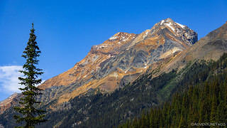
The mountains; rainbows of rock.
Near the end of the trail, a couple old mining cabins lined the road. These were once substantial structures, each of them 40-feet square, and two stories - plus an attic - tall. With hand-hewn logs and dovetailed corners, I couldn't help but to admire them for the better part of 15 minutes or so.

Mining cabin sunstar. You can make out some of the planks from the second floor, falling down just inside the door.

These notches once supported the second story floor joists.
Beyond the cabin we found several camp sites before crossing the creek that marked the end of the trail. Or rather - as with seemingly all trails here in Canada - the beginning of the snowmobile section. I donned my Muck boots, and for a while we just enjoyed the view up the valley, each of us clicking away from various angles.

It seemed that nearly everyone got to this point - and even a few feet further - but then turned around.

So similar, and yet nothing the same.

Time to go!
It was 11:00am when we headed out from Bruce Creek, retracing our path back toward Radium Hot Springs. We had no intention of returning all the way to town - and, in fact, we even attempted a shortcut to our next trail, just one canyon to the north - but we did have a good bit of repeat road before we'd begin the highlight of our trip.

Our shortcut foiled by private land, we stopped for lunch at a series of pinnacles along the bottom of Forster Creek.
And then, at 1:00pm, it began. Our journey to hallowed ground. A place I'd heard about but never really comprehended. Not until I experienced it for myself...


You often are unsure of the names of peaks you see. You really need PeakFinder, an iOS or Android app that "knows >950,000 peaks.. It is cheap and remarkably good.
Thanks Anthony, I'll check that out. A lot of times - most of the time really - I don't really care what a peak is when I'm out exploring - I just like seeing the beautiful landscape. And, if I'm driving or hiking, I don't really want to get my phone out to figure out the name. Rather, I try to figure them out when I'm back home and looking at a map, after the fact, hahaha!
Beautiful photos as always. WOW, FREE ferry ride, wouldn't mind trying some of those but doubt that we will every make it that far north so appreciate your photos and tales even more. Agree about bugs. I love the High Sierras but restrict visits to early spring or late fall to avoid the nasty little flying buggers. Hate to be hiking/backpacking and have them in my face all the time. Looking forward to your leg of your trip.
The first time I got on one of those ferries, I was like, "wait, what?" when they just let us drive on. Super cool. I suppose the good Canadians are paying for our rides with their road taxes.
+1 on the buggers. I'm always looking for windy spots, just to avoid them!
That's not the end of the bruce trail!! Check out @dirt_garage on youtube, we went in to the lake at the end! It's a gnarly trail tho, and left some dents on my tacoma!
Oh man! After we crossed the creek there, we kept going for a quarter mile or so but the trail seemed to peter out in the meadow and get really mushy-muddy. That was also the end of the track that *someone* ? sent me, so we thought we were done.
Edit: I'm watching the video now, hahaha, and maybe I'm glad we didn't continue.
Great views! Really enjoyed!
Happy to hear that Bill, always nice when a story and some photos can bring even a taste of the trip to others to enjoy along with me!
Wonderful!
I'm glad I can sit in my armchair and go places with you as my guide! My GMC Sierra doesn't like narrow trails. Though I do. But since she's in charge, I won't be able to visit some of those places you go to. But the rest.... I'm taking notes in hopes I get the chance to go where you've been!
Thanks, Dan ... for giving me a chance to see B.C.. and I'm waiting for the next installment!!
As always, I enjoy the pictures, narratives and humor you inject into your travels..
David
Thanks David, come along in the armchair any time - I know I do it plenty with other folks trip reports!
I really do appreciate you photo albums you upload, and the time you spend making them. I really appreciate your eye for beauty - like the geology, and things most people wouldn't look at or know about. Until the day comes when I can take these trips in my Taco, these will do just fine!
Thanks so much Monte! You're welcome to read for as long as you'd like - I still read lots of other trip reports even though I'm getting out there myself. The other ones just become "ideas for the future" at that point! An endlessly growing list that I'll never get through, ha! ?