
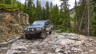
Having spent the last six days on the New Mexico Backcountry Discovery Route (NMBDR), there were a few things that needed our attention before we knew exactly what our next move would be. Pulled over where the last of the dirt hit CO-17, we each had one bar of LTE service and we set to work.
I made a quick call to Alcan Spring - in Grand Junction, CO - to check in with Lew, the new owner. Having very much liked my first set of leaf springs, I'd ordered my second set several weeks earlier. Before leaving on the trip, I'd talked to Lew and estimated that the BDR would take us a day longer than it actually did, and as such had suggested that I stop by two days from now, rather than one. Lew was super understanding and suggested that if I showed up at the end of the follow day, they could have my springs ready to go. Perfect!
@mrs.turbodb made a similarly quick call to her dad - a resident of Colorado - to let him know that we were in his home state, but pretty much as far away within the state as possible. Rather than adding several hours to our already long drive home, she worked out a plan to go camping with him later in the month. Perfect!
With those coordination's worked out, everything sort of just fell into place - we'd head over to the San Juan's, spend the afternoon and following morning running a few trails in The Alpine Loop, and then wander our way north to Grand Junction to pick up the springs on the way home.
As usual, if only it was that easy!
We turned west on CO-17, and within just a few miles we were back in New Mexico on NM-17. We wouldn't be in New Mexico long - just long enough to get fuel in Chama and then head back into Colorado toward Silverton - but as we crossed the state line, we felt like a huge weight was lifted from our shoulders.

Now that we were on highways and fully aired up, there wasn't much to do except listen to podcasts and - if you weren't driving - nap. Miles and minutes ticked away and before we knew it, it was lunch time. We'd already seen signs for Chimney Rock National Monument, and @mrs.turbodb suggested it as a good place to stop, since it would most likely have picnic tables.
However, just as we got to the turn off, road construction was snarling traffic, so I suggested that we continue past the slowdown and find something where we wouldn't get stuck when we were done. This worked out just fine - a local campground providing shade and tables - except that we later discovered what Chimney Rock actually is. Besides the rock formation - which is what we could see from the road - the site also contains more than 200 Ancestral Puebloan homes and ceremonial buildings high above the valley floor, built more than 1,000 years ago.
Oh well - we probably couldn't have done it justice anyway, and this will give us a reason to return!
A couple hours later - now nearly 4:00pm - we found ourselves in Silverton, and the situation was... not what we expected.


Not sure exactly what to do - but knowing that we didn't want to drive up into the loop, only to camp in the rain and miss all the views - we decided that we might as well just take US-550 to Ouray and hope for the best from a weather perspective once we got there. We'd miss the few trails and views I'd planned to show my co-pilot, but it's not like we were going to do enough anyway to avoid a return trip.
And then, just as we were going to head out of town, the rain let up a bit. I suggested to @mrs.turbodb that, "maybe we should just drive up the Hurricane Pass Road a little way, so you can get a better view." And then, I added, "No matter what, we'll turn around after half an hour at the most."

The main, well-graded road was shorter than I remembered, and within 10 minutes we were turning up Hurricane Pass - still fully aired up and moving quickly - my hope that the clouds would clear enough that we'd see the snow-capped mountains.

With the rain completely stopped by now, I looked over and suggested that we go, "just a little further so we can look back on Corkscrew Gulch." I could see that my suggestion didn't land completely, so I added, "It was my absolute favorite thing when I was here last time."
We pressed on.

Getting back in the truck, we were at minute 24 of my 30 minute time limit. With the progress we were making, and what was turning out to be reasonable weather, I suggested - in a joking/not-joking sort of way - that. "maybe we should go back to the original plan," and just follow a few trails to Ouray, rather than go all the way back to Silverton and driving on the highway.
She was not amused.
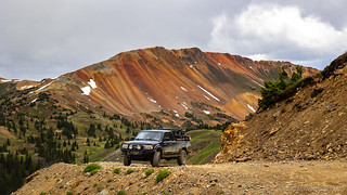
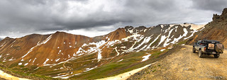
In the end though - and after a bit of "discussion" - we did continue on - our route taking us up and over Hurricane Pass, then through California Pass and down to Animas Forks, and finally out Mineral Creek (via Engineer Pass) to Ouray.


Unfortunately when we arrived at Animas Forks - a place I'd not really gotten a chance to explore the first time I visited the loop - the rain was coming down in buckets. We read the information signs, but neither of us wanted to get out and explore the numerous cabins and outbuildings - it was just too wet - so we just continued on up Engineer Pass.
We should have just waited, because just as we were a little too far to turn around, the rain stopped entirely. For us though, it was too late.

Like Hurricane Pass, Mineral Creek was a trail I'd not run previously, but we'd talked to a caravan of Jeep Cherokees when we were at the top of California Pass to ask about road conditions there, and they let us know that it wasn't bad at all - just a little rocky. So, we climbed up the bottom section of Engineer Pass and then turned down Mineral Creek - sure that we'd be in Ouray shortly.

Our descent was significantly slower than either of us expected, and I'm pretty sure that "not bad at all" is not the way @mrs.turbodb would describe the road. It was definitely rocky - but in the Alpine Loop sort of way - ledgy and off-camber, with switchbacks and steep drop-offs. It was nothing uncomfortable for me - I enjoyed it after a week of tame gravel roads - but expectations and reality for the passenger didn't match up. Still, she was a trooper through it and she definitely enjoyed the surroundings.


Two-and-a-half hours after we set out on our little section of the Alpine loop, we transitioned from Mineral Creek Road to US-550 - the highway we'd have taken from Silverton - for the last couple miles into Ouray. Not quite to town, we stopped at Bear Creek Falls to the sound of rushing water.

Though it hadn't taken us long, we hadn't gotten an early start either - so it was nearly 8:00pm when we found a perfect little spot north of town to eat dinner and watch the last rays of sun stream under the clouds and onto the San Juans. This range definitely holds a special place in my memories.

The Following Morning...
Luckily for us, we'd found camp exactly where we'd hoped - on a little slice of BLM land high above Montrose, on the way to Black Canyon of the Gunnison National Park.
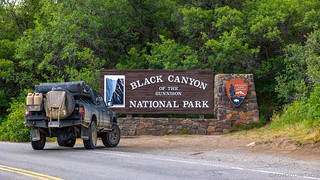
Having completed the Alpine Loop trails earlier than expected, there were no complaints from us, adding this extra stop.
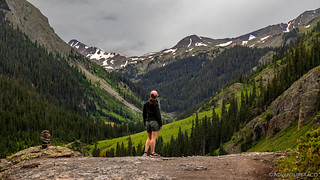
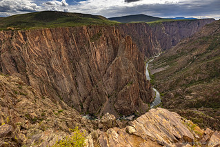
I'd never heard of Black Canyon of the Gunnison before @mrs.turbodb found it on the map while looking for ways to pass as the rain poured down on us in Silverton and we thought we wouldn't run the Alpine Loop at all. As we climbed the last few miles to the canyon rim and visitor center, she - as usual - read a bit about what we'd be seeing.


Upon arriving at the visitor center, our first order of business was to wander over to the park rangers - stationed outside at folding tables and wearing masks - to enquire about how to best see the park, pick up a map, and of course show our America the Beautiful pass. But all of that was quickly forgotten as we both spotted a sign that read, "Join us for a ranger-led geology walk at 9:00am."
I knew immediately that we'd be going on this walk, and @mrs.turbodb was elated when I said I didn't mind at all. With 15 minutes to kill before the lesson began, we headed back to the Tacoma for a quick breakfast, and grabbed some water and sunscreen before setting off.
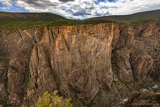
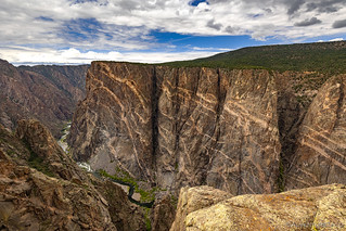
The views of the canyon really were fantastic, and once the geology lesson - which, may have been a lesson for the ranger, from @mrs.turbodb - was over, we stopped at several more overlooks just to get even more perspective.


And with that, we were done. There's certainly more to see here - and hikes down into the canyon to explore - but we didn't have time for that today. Instead, we took one last look at the stars and stripes as we drove out of the park and headed north towards Grand Junction.

A few hours later we arrived at Alcan Spring, the weather hot once again - rain nowhere to be seen. I must say, I was a little nervous pulling into the parking lot - sort of like a fan who has watched enough of a show to feel like they "know" the actors... and actors who have no freaking clue who the fans are! 
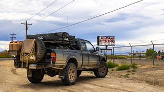
Walking into the office, I mentioned who I was and that I was there to pick up my leaf springs. After bit of scrambling on the other side of the counter and I was told that my springs weren't ready.
"I talked to Lew yesterday, and he said they'd be ready this afternoon," I said - now speaking to both the saleswomen as well as another gentleman who'd joined from the back office.
Turns out that other gentleman was Lew Weldon - the new owner who bought the business from Bill Ford late in 2020 - and he quickly introduced himself before apologizing to his staff for not keeping them fully in the loop.
And then, he went out into the shop and found my springs. They weren't quite done yet, but rather than telling me to come back the next morning, or getting on his guys to finish them up, Lew stepped right in and finished up the final few steps of fabrication and assembly!

Twenty minutes later - the final steps complete - Lew personally measured each of the springs to ensure that it met all the custom specifications we'd discussed, and then had me back the truck up to one of the big doors and personally loaded the springs into the back of the Tacoma.

Now that was some great customer service. And it's one of the reasons I'll keep ordering from Alcan in the future. For now though, it was time to get home. We'd been on the road - showerless - for 10 days, much of it in 100+ °F heat. It smelled like human in the truck, and we still had 20 hours of driving in front of us.
Thanks for reading, hope you enjoyed it!
Love the Alpine Loop? Check out
Alpine Loop Index
for several more fun stories.


I just saw something about Animas Forks on one of the Discovery Channels this week and am making plans to go there next summer for a week or two.
Nice! Animas Forks itself is just a small ghost town, so will only take an hour or two to look around. Maybe an afternoon. But there is so much to see in the San Juans and Alpine Loop that you could easily spend two weeks - or at least I could! Have a great time! ?
Definitely return to Chimney Rock and take the guided tour. Plan on taking most of a day to do it justice, and your camera will stay very busy as well. I stayed in the Ute National Forest campground, which was just a few miles to the west of Chimney Rock.
Thanks Lapsley, we will definitely plan on it! And - we ate lunch at that same Ute NF Campground that it sounds like you stayed at! Small world. 😁
Yes, small world indeed, and even smaller when you consider that the camp ground host at the Ute campground was originally from the same area I live in eastern Tennessee. And, her brother lived in the same town as I do, and actually was a teacher at ETSU (East Tennessee State University) where I did post graduate studies (many years ago). She and her husband had been full time RV'rs for over 20 years.
In three weeks I'm headed back to Colorado and Utah to do a month of exploring (all off road of course).
Another fine trip completed, excellent photos once again, makes me want to head that way. Challis is calling on Wednesday to do some exploring of the old mines and lookouts.
Thanks Kenny! Hope you had a good time in Challis and it wasn't too smoky.
What happened to your leafs ? Something break? Change in performance?
My leafs are fine actually. I got new ones for two reasons:
Turns out - as you can tell in the story - that Lew, who bought Alcan from Bill last fall, is keeping things pretty much the same as far as process and quality goes. His service was as good - if not better - than what I got the first time, and from chatting with him, it sounds like he's done a lot to increase business by like 2x-3x at this point.
So really, I could have waited and not had a problem at all (it seems). But, now I'm happy that I stopped by when I did, just to meet Lew and say "Thanks!"
I always loved Oregon but mostly the coasts was all i ever got to see. Never realized those beautiful craggy mts were there. I never get enough of the rocks, crags and beautiful mountains like you saw. Would kill for the rain yall avoided cause we NEVER GET ANY IN SO.CAL. Thx for the trip and great shots!
Another great trip report, keep them coming!
Great Adventure and Pictures! One of the get stories that once you start, you can't put down!
Glad you enjoyed it Bill! The Alpine Loop never really disappoints IMO - like the story, once you get there, you never want to leave!
Ah, what a great review of one of my favorite parts of the state. I used to live south of Durango, in a tiny town on the Southern Ute Indian Reservation. Went to the San Juans many times. The last time I was there was August 2021. Went up through Lake City to the Alpine Loop, only because highway 50 to Ouray from Gunnison was closed for construction and I was coming from St. Elmo. A couple of people along Engineer were very surprised that I was traveling the pass solo. It was one of the easier mountain passes I'd ever been on, I don't know what they were afraid of. Also went over Hurricane and California. Met a bunch of very nice bikers on California. I always take pictures of the signs at the summits (I noticed you did that on Imogene), and they were going to get out of my shot. I told them don't you dare, but I do avoid taking photos of people.
There's a cabin along Engineer I would love to live in. Thoreau's Cabin. You can't miss it. Shhh, don't tell anyone.
This was a trip of not only high mountain passes, but also abandoned mines and ghost towns. Animas Forks was very intriguing, tons of history in those mountains. Camped at the Sunshine Mill at Eureka. Stopped at Gladstone and Howardsville. I'd wanted to go up to Old Hundred Mine, but didn't make it. I didn't get over Cinnamon either.
I have been using Charles Wells Guides to Backroads and 4-Wheel Drive Trails, but I also do tons of research on line. There are a couple in the Ouray area that I wouldn't touch with a ten-foot pole as I'm not very experienced. Poughkeepsie is one, Black Bear and Mineral Creek Trail. I have been over Imogene on a family trip. Also Ophir with my son.
Despite all these trips over the years, there is still so much to see and do. Time to plan another trip.
Glad to hear you liked it Darlene! The Alpine Loop something I'd wanted to see for quite a while before I visited it the first time as part of a two week trip to Colorado. (Specifically, check out parts 10, 11, 12, and 13 of that trip - which included Poughkeepsie and Black Bear ?.) I found Mineral Creek to be more difficult than Black Bear, though of course the consequences on Black Bear are...major!
Love the story about the bikers! I try to take a photo on most passes as well, but they don't always make it into the story, as I have to prioritize scenery pictures over signs, sometimes.
There's always more to do, isn't there? I'm planning my next outing... always!