
Note: Visiting Butler Wash requires a pass. For more information, check out BLM Utah Cedar Mesa Permits and Passes Information.
Our personal side canyon off of Butler Wash was the perfect place to spend the night, and though it was a bit warm - I think it only got down into the high 50s overnight - we were both extremely tired and so enjoyed the ten hours or so of horizontal existence immensely. Still, we knew that the best way to beat the heat of the day was to get going early, so when my alarm went off just before sunrise, there was no better time to start the day.

Why yes, I would like another fabulous day, thank you!

What a way to wake up.

OK, now I'm just playing with angles.
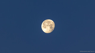
The moon was out in glorious form.
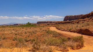
We put away the tent and held off on breakfast - opting instead to get a hike under our belts before taking a break for food - and pointed the Tacoma back toward Butler Wash Road and Comb Ridge.
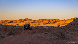
Comb Ridge glowing a warm orange in the morning sun.
Retracing our steps to the Procession Panel trailhead, we were quite happy to find that the small gnats from the previous evening were MIA - the cool(er) morning air likely keeping them at bay for the time being. I setup the solar panels on the windshield - which would serve to keep the cab a bit cooler and help the batteries maintain charge through the day - and we started our trek through the wash and up the ridge towards our destination.

Long shadows make for pleasant hiking.

This is the way.
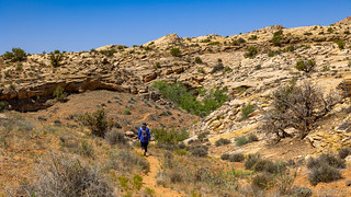
The hike up to the Procession Panel was nothing like the hikes we'd done the previous day. Whereas those had been in canyon fingers, this morning I was surprised - and excited - to find us actually climbing Comb Ridge. Of course, it made for a bit tougher hiking, but it was a special experience to climb a ridge that I'd been admiring ever since I saw it a month earlier.

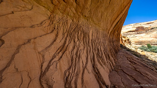
I really enjoyed the color of the water staining on this glowing face, especially against the blue sky.
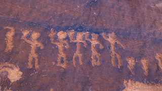
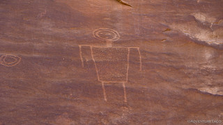
As we neared the location of the panel - and as is often the case - several smaller areas of petroglyphs presented themselves. Even with a full day in front of us, we couldn't help but to stop and take a look, as several of the glyphs were intriguing.

Man with a snake.
Man with short legs.

Skinny man with a ... 

Etched hand, mine for size comparison.

Admiration.
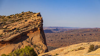
At this point, we were already starting to get a good look at the top of Comb Ridge, and though I probably couldn't have articulated it at the time, my brain was already working out how we could get to the top as we continued up towards the panel we'd come to see.
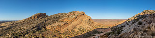
I really like how the ridge tilts upwards in waves, and then drops off precipitously to the west.
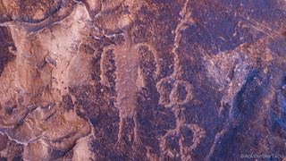
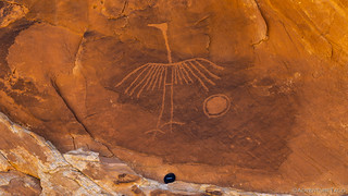
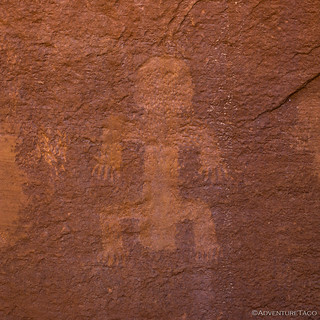
It was only a few hundred more feet before we reached the Procession Panel. Named for the nearly 200 figures that are arranged in three processions toward a central ring, the panel is nearly 30 feet wide and contains all sorts of interesting etchings. It's worth some time to inspect the various segments to see the varying details added by the artists.

The entire procession.

Coyote chasing a sheep; people watching and pointing.
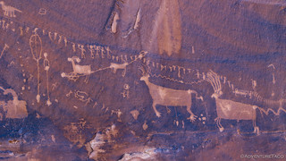
The southern procession. Interestingly, two by two.
Men with fingers. An interesting detail that I'd not seen before our hikes here along Butler Wash.

Gazzelle man.

A frog? And man with headdress.
After spending a bit of time pointing out various aspects of the panel to each other, I could tell that @mrs.turbodb kept glancing in the same direction I was - up to the top of the ridge. We'd actually had the opportunity to go to a site called Ridge Top Ruin the previous afternoon, but decided against it given the heat and all the other hikes we'd already planned.
It's funny how things work out - we'd had no idea that the Procession Panel would bring us so close to the top - and even if it was already starting to get a bit warm, we weren't about to pass up this opportunity!
One tooth of Comb Ridge.

Sitting on the backbone of the earth.
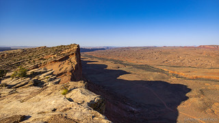
Backbone of the earth, without that distracting guy in the way.
We probably spent 20 minutes at the top of Comb Ridge. As we admired the view, I pointed out several of the places I'd been on my previous trip - roads I'd driven, general areas of ruins and pictographs - that kind of thing. We also had four full bars of LTE, and spent a few minutes checking in on real life before setting back down the way we'd come.

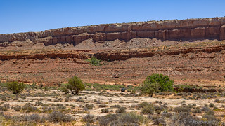
We stopped only once to capture this beautiful sandstone face on the two mile descent back to the trailhead.
It was still before 9:00am when we arrived back at the truck and feasted on full bowls of Cheerios and blue berries. But what I remember most was remarking to @mrs.turbodb about how great cold milk tastes. It was already getting warm outside.
Our bellies full, we piled back into the Tacoma and turned the A/C to full before ordering up another serving of history from Butler Wash.
Our view north, as we rejoin Butler Wash Road and head south.
Early on in our next hike - the heat of the day now beating down on us from the start - we were strolling along when my peripheral vision registered an out-of-place shape to our right. There, a couple dozen feet off the side of the trail, someone had constructed a teepee out of sage. We'd see one other similar teepee at the end of this hike near Double Stack Ruins, so I'm not sure if they are historical or newer additions to the landscape.

This teepee was pretty small - only about 10 feet tall.
The remainder of the hike to Double Stack ruins was reasonably uneventful. It was a short hike - relatively - and soon we were rounding the final bend in the wash before reaching the aptly-named cliff dwellings built into the sandstone walls.

The upper ruins.

The scream wall.
Double Stack ruins weren't the most amazing that we'd seen - the wooden fence around the lower ruins a sure sign that traffic was heavy here; heavy traffic one of the things that ages a site like this quickly. Still, there were a few interesting details that we noticed as we enjoyed the shade of the sandstone recess.

The mud chinking had some seed pods pressed into it, in addition to the standard small rocks. For decoration?

Red and yellow hands.

Small granaries built into the wall.
And with that, we wrapped up our second - of five - hikes on the day. As we were making our way back, the conversation touched on the trip report for this adventure. I remarked that it'd be quite different than most trips, where there's a lot of variety throughout the day. This trip - on the other hand - would be "ten, two mile hikes to essentially the same destination." @mrs.turbodb assured me that it would be OK.

Making our way a couple more miles south. In all, we'd drive 25 miles down Butler Wash and hike 21 miles into Comb Ridge.
Parked and with the solar panels once again serving double duty as dashboard saver and power generator, we slathered ourselves in sunscreen and ventured once again onto the hot sandstone of Comb Ridge.
Even though it was hot, long sleeves and pants were a must to protect us from the sun.
Something interesting that I noticed as we worked our way from north-to-south along Butler wash was how the terrain changed. It was nothing visible at a macro scale, but when hiking on foot, it was clear that the canyons into the southern part of Comb Ridge were shallower than those to the north. Where we'd been walking in sandy washes the day before, with only a couple hundred feet of elevation gain, today we were walking up Comb Ridge itself, to higher washes, not worn down as far as their northern neighbors.

I was sure our destination was in the shady overhang. Wishful thinking on my part, it was above it.
Unlike Double Stack ruins, the trail to Big Crane was very lightly travelled. We saw only a few cairns - and even fewer footprints - along the way, perhaps due to the fact that there wasn't a large ruin at the end. Instead, a single glyph decorated the wall. It was - for me anyway - the highlight of the day.
Look at that beauty!
The Big Crane was quite striking. I'd hike to a piece of art like this over a ruin site almost any day. In fact, this specimen reminded me of the Thunderbirds we'd seen on a previous adventure in Death Valley. It was fantastic to me that two groups of people, so far apart, could draw such similar images. Life is mysterious for sure!

The sandstone domes reminded me of their granite cousins in the Sierras.
As we returned to the Tacoma once again, talk this time was of lunch. We'd parked near a large cottonwood tree that would provide ample shade and a nice overlook of Butler Wash where we could enjoy our tuna sandwiches, cool apples, and some salty potato chips. Unfortunately, we'd be stuck with warm water to wash it all down, rather than cold Coke. Oh, how we suffer.
Lunch mobile.
Because this cottonwood was growing in the bottom of the wash, and we were sitting on a bank some 20' higher, it was like eating lunch in a tree house - fantastic!
For our final hike north of US-163 on Butler Wash, I'd planned to have us visit the Wolfman Panel. As a bonus - given that it was now early afternoon and right around 95°F - this was a short hike. Or at least, that's what I'd planned. You see, the research I'd done suggested that we could drive half a mile or so past the 2WD parking area along a road suitable for 4WD vehicles (which we have)! Unfortunately, the BLM has since closed the 4WD portion of the road, adding an additional mile to our journey.
Oh, and while short, the hike entailed lots of elevation gain, since we had to descend and ascend both sides fo the canyon. Genius plan revealed for what it really was: typical me.

I said it was short, not easy.
About halfway into this semi-loop trail, we found ourselves at the Wolfman petroglyph. It was actually a collection of glyphs, and I'm not sure the namesake was even my favorite. The one unfortunate detail was that - perhaps due to accessibility near the highway - these panels had more gunshots in them than others we'd seen elsewhere.

These geometric T shapes reminded me of the H glyphs at Kohta Circus in Gold Butte.

These were my favorite images in this area. There's so much going on there, and so crisp.

Waving man says "Hi"!

The Wolfman. Note also the Crane, where the bottom has fallen away. 
From the panel, most people just head back up to their parked vehicle, with children instructing the parents to, "Turn the A/C on full blast." as soon as they get back - at least, that's what we witnessed. We, however, had a different plan. Across the wash and up the other side of the canyon was a small set of ruins. As is often the case with us, the phrase, while we're here, was thrown out, and we headed that direction.

Not the most interesting ruins, but there was a brugmansia struggling to survive, which we found intriguing as it is a plant we've grown at home in the past.

I don't know what made these little holes in the rock of the ruin, but I thought they were cool.
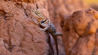
Ruin resident. Collared lizard is always dressed up for visitors.
From here, we made our way back down and through the wash - a journey that was just as hot and sweaty as it'd been on the way out. Not missing a beat, @mrs.turbodb instructed me to, "Turn on the A/C full blast." as we neared the truck. Touché!
I was happy to oblige the request, and we drove the seven miles - to our fifth and final hike of the day - extra slowly. By now, we were south of the highway - along Lower Butler Wash Road - and were surprised when we got to the end of the road and found a Jeep already parked there!
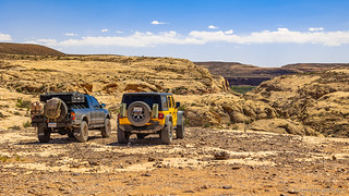
AdventureTaco meets HAPPYJL, also from Washington.
While this was our last hike, it was also the longest - a point that was lost on neither of us as we filled our water and mentally prepared for the trek that would take us to the terminus of Butler Wash and the San Juan River.
Then, just before we set off that we saw this guy. Over a foot long, I could have watched him forever.
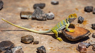
Green-and-yellow collared lizard's friends say he's just a show off.
As we hiked down through the wash - which had really turned to a canyon at this point - there were several ruin and rock art sites along the way, and we stopped at several of them to check them out.
The first was rather bland, and required quite a bit of vertical feet to access. @mrs.turbodb made the right decision to sit this one out.

As if she knew it would be only "meh."
Fingers and toes.

To me, this was the most interesting mystery in the first ruin. What was it for?
The second ruin was much more interesting. Larger and better positioned than the first, we found tons of cool artifacts here. Most interesting were the dozens of metates and smoothed grinding stones that lined the floor. Ancestral Puebloans must have sat here for hours looking out on the wash.

Metate manor.
Get your mind out of the gutter.

Metate's and stones.
I really liked the sandstone layers here as they peeled away.

There weren't many petroglyphs here, but the few that existed were well preserved.

Jazz hands and feet.
As is always the case with a hike, the main attraction was at the end. Or the middle, depending on how you look at it. At any rate, we were just coming to the mouth of Butler Wash and its intersection with the San Juan River when we saw a much newer glyph - of a rancher no doubt - who'd been through a little over half a century ago.

November 14, 1958.

Tempting to swim in!
Having reached the end of the trail, we moseyed along the face of the cliff until we came on the panels we'd been looking for. They were covered in petroglyphs, and we spent fifteen minutes or so walking from one to the next, searching for our favorites.

Mother earth, envisions man?

Men riding animals. Anatomically correct men, you'll note.
Man with a halo.

The angel on my shoulder.

Bird brains.

I really liked this deer being chased by a badger for some reason.

Sunstar over panel.
By now, it was 4:45pm, and we had a couple miles of up to get back to the Tacoma. Luckily, our spirits were high after all we'd seen on the way down, and so we set off at a good pace - the return trip always a faster once since we've generally already seen everything on the way out. We were, however, surprised to have not seen the occupants of the Jeep we'd parked next to, and we wondered if it would be there upon our return.

On the way back, we discovered these petrified wolf (?) tracks.

Where could the Jeepers be?
A little concerned about whether the occupants were OK, there wasn't much we could do, so we hoped for the best as we retraced our path to the highway and headed west. We'd hiked a little over 14 miles, bringing our total so far to 25; our feet were ready for a break. Luckily for them, the rest of the afternoon would be driving, as we wound our way through the Valley of the Gods and up the Moki Dugway on our way to camp.

Our final view of Comb Ridge, and Abajo Mountains in the distance.
I'd been by Valley of the Gods a month earlier, but I'd not driven through, so it was nice - though we came when the light was exactly wrong - to take a leisurely tour through this very popular place. We joked - as we passed (and our dust cloud enveloped) RV after InstaVan after Broverlander parked just a few feet off the main road - that they must be wondering why we wouldn't stop in any one of the "fabulous" camping pull-outs. No thanks.

Rooster Butte (left) and Sitting Hen Butte (right).

Monuments rising up to the sky.

De Gaulle and His Troops.

Lady in a Bathtub.
Despite the crowded nature of this place, it does seem like it could be a really fun spot to explore - as long as it's done in the middle of a non-busy week, and in the early morning hours when the sun is at the correct angle for the vast majority of buttes. For now though, we were both ready to get to camp, and all that stood between us and some quality horizontal time was the Moki Dugway.

It's no Morrison Jeep Trail, but this is not the road where you want your brakes to fail.
Soon enough, we arrived at the trailhead for what I hoped would be the highlight of our trip. That would come the following morning - when we hiked down Bullet Canyon and back out Sheiks Canyon, winding our way through the Grand Gulch for some 17 miles - so for now we simply sat in our chairs and enjoyed the warm breeze as we made and consumed a delicious dinner. It was - as frequent readers might guess - tacorittos - which hit the spot after such a long day.

Home is where the tent is.
We were both exhausted as we climbed into the tent. Quite honestly, I wasn't sure if we were biting off more than we could chew with our plan the following day. We would, I suppose, find out. My alarm was set for 5:00am.

 - Cedar Mesa #3")

I believe that little teepee you passed along the way are the remains of an old Navajo Sweat Lodge.
Really? That's cool. We weren't sure if they would have held up (so well) for that period of time. Obviously it's possible, given all the wood in many of the ruins, but that is generally better protected from the elements, easy destruction by present-day humans, etc. Awesome to hear though - makes me want to research the sweat lodges a bit more! ?
The petroglyphs are bitchen in this area and so many of them. I wonder what happened to the civilization that roamed here? Do you know what the people were called? Aztecs? Mayans?
Very interesting, thanks again for sharing.
These are mostly Ancestral Puebloan (1000 BCE - 550 CE), which you often find referenced as Anasazi (now a dated term). They inhabited much of the Cedar Mesa area, and built numerous cliff dwellings in the sandstone walls. One of the best I've seen was Moonhouse, and it was fantastic.
Your photos are so crisp and clear. It's like I can touch and feel the stone walls. Beautiful trip...thank you once again for a sweet, trip, even the x-rated parts lol wink wink. Seriously, I need some great weather, not hot, and a good road trip to get among the rocks again. beautiful. I appreciate once again that yall did the walking for me.
Another home run! Thanks guys! Great photos and content. Love it. Paul