
The night air was warm - probably 15°F warmer than it'd been in Eureka Valley - as the stars spun in the clear sky above. It was a great night, tucked away in our quiet, secluded corner of Saline Valley.

Once again having gone to bed early, it was no trouble getting up a little before sunrise. I wasn't sure we'd really get anything with cloudless skies and our position relative to the Inyo Mountains and Panamint Ranges. And in the end, there wasn't much except a bit of color in the sky, but even that was extremely pleasant as I sat overlooking the valley in a short-sleeve shirt, reading The Athena Project on my Kindle.


We had another full day in front of us, our slower-paced plan now a distant memory. A couple more hikes, exploration of a silver mine (that was an ad-hoc addition to the trip), and a hunt for petroglyphs hidden somewhere in Saline Valley before heading off in search of another great overlook where we could spend the night.
And here - once again - I should mention that I'll be doing this out-of-order and with a bit of obfuscation and/or redaction of certain places. If you know where they are, please do your best to keep them special as well! That means refraining from sharing specific locations, wandering off trail, and touching any rock art that you find. These places have a hard enough time surviving in a desert environment, without having to compete with the chaos that inattentive humans can bring.
With the sun streaking higher in the sky, @mrs.turbodb was soon out of the tent as well, and as got to prepping breakfast, I poked around a bit in the ruins of the dilapidated Salt Tram where we'd set up camp. There I found the usual suspects - old wood, nails, brackets, and cabling - but also a few unique items as well. The coolest - in my opinion - was some turquoise glass, which reminded me of the purple glass we'd found at the Champion Mine in Colorado.

Cereal - and some of the best store-bought blueberries I've ever eaten - consumed, we packed up the kitchen and tent and got on our way, heading back down toward Saline Valley Road from our camp at the base of the Inyos.

Now, one of the treasures of Saline Valley are the ███████████████████████████ petroglyphs. Located well off the beaten path, one has to find the right spot to park, and hike for a couple miles across the desert in the right direction in order to even hope to find them.
I'd discovered them - or hints about them - in several places during my research of Death Valley, and before we left on the trip, I was pretty sure I'd figured out their location. We wouldn't know for sure until we got there however, and so after making our way to a point I'd marked on the map, we parked the truck and set out on foot.

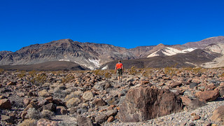
A hike like this is always a bit of a gamble - I mean, you never really know if it'll be a success or not until you're fully committed - so it's always nice to look for little things to enjoy along the way... just in case there's no pot of gold at the end. Today, the little things were easy to enjoy. Somehow - I have no idea how - I happened to look down at the ground at just the right time to see a large chip of obsidian.
I've never seen obsidian here before, but I took it as a good sign that we were headed in the right direction for Native American art, and continued on.

The flora in Saline Valley - well, all of Death Valley really - is always amazing. With a name like Death Valley - and the desert climate to go along with it - I'm always struck by the color and beauty of the plant life. Along the "trail," we found numerous cacti - the red cotton-top cactus and chollos, especially vibrant.


Eventually, a couple miles into our trek, we reached the edge of the valley and the mouth of the canyon that we hoped would contain our treasure. As the walls rose up around us, we pressed on.

Now was the moment of truth - sort of. A better analogy would probably be a slow motion highlight reel - or train wreck - depending on the outcome... because even if we'd found the right canyon, it was still a rather sizable place, and locating the carvings in the rock wasn't necessarily going to be an easy task.
When visiting rock art and ruin sites, be respectful.
This is most easily done by following the Leave No Trace principles; leaving the place exactly as you found it and taking with you only photographs and memories. In case that is not clear enough for some reason, here are examples of respectful behaviors:
Making our way back and forth across the wash, we inspected the walls as we headed deeper into the canyon. Eventually, we ran into the first panel, and we knew we'd found the right place!
I present to you - lady holes.
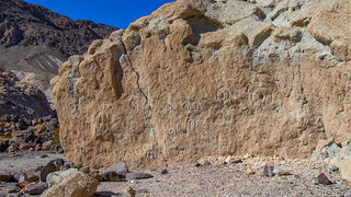
It's not known exactly what these figures represent, but it is purported that this was perhaps a fertility site, and these figures represent pregnant women - large bellies and oversize belly buttons, depicted on the rocks. Much like the yoni that we found further south near the Blue Sun Cave.
Now excited that we were in the right area, we pushed on further - our goal was to find a series of birds known as either Thunderbirds or Condors.

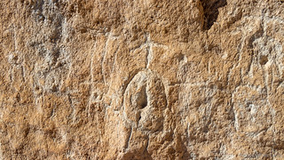
It wasn't long - at least relatively - before we found the next panel. This one had more variety than the first, various shapes and several different creatures depicted.


It was almost as though this second panel was a "scratch panel" of sorts - the carvings here seemingly scraped over in various places as though the artist had been practicing.


There was even one condor, its speckled chest a reasonable representation of how sunlight can sparkle off the condor’s feathers. I knew from photos though, that this was not the condor we were after!

Our heads now on swivels, we headed deeper into the canyon. Then, to our left, I spotted what seemed to be the perfect place for another panel. Elevated above the wash, with a 10-foot wide flat area in front of it, we found not only the panel we'd been after, but also the remnants of an old shelter.
This was clearly the masterpiece. The figures here were more refined, the carving in the wall deliberate and well preserved.


And here, we found the condors we'd been looking for. They were nothing short of amazing, especially given the tools and medium used to create them.


Having found what we were after, we knew we could happily spend the rest of the day in the canyon if we just kept wandering up. At the same time, we knew there was a lot more on the docket for the day, and so after one more panel, we decided to head back across the desert in search of our 4-wheeled transportation.

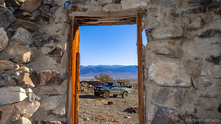
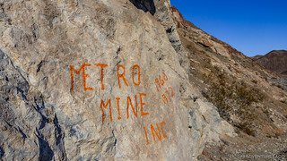
If the ███████████████████████████ petroglyphs are one of the lesser known attractions of Death Valley, something I think many more are familiar with are the plethora of mines found throughout - and around - the park. One that we hadn't planned on visiting but decided warranted a look as we read about it in Hiking Western Death Valley, was the Big Silver Mine. Nestled into the base of the Inyo mountains, it produced over 7,600 ounces of silver via five separate mine shafts that were sunk into the mountain - all of them accessing isolated segments of what was once a single quartz vein before being broken by numerous faults and dikes over the years. Today, it's projected that vein still contains over 90,000 pounds - or nearly $22 million dollars - of silver!
As we reached the end of the road - the location of the Big Silver Mine camp - there wasn't much left. A stacked-rock structure built at the base of the hillside and a large, rusty, old camp stove that we partially reassembled (the back had previously fallen off) were really the only things worth checking out.


But that wasn't why we were here - not really. We were here for the mines. I mean, what if we found a million bucks of silver as we explored the hillside? I'm sure the truck could handle the additional 4,100 lbs and cart it off! 
The first mine shaft was easy to find. Clearly a road had been built to this shaft in the past, and a sign along the way suggested exactly who'd done it...and when.

Completely open, with no warning signs or anything, this must be either a relatively low-traffic site, or one that's much more stable than others found throughout the park. And, while it was clear that we weren't the first to investigate this area, we mostly stuck by the mantra, "Stay out, stay alive" - only entering a few feet in order to capture the ambiance.


Having failed to strike it rich at this first mine, our curiosity rather than silver fever propelled us forward. The trail - much like the Salt Tram trail - quickly became more of a path, more suitable for hooved animals than human travel. This, it turns out, is a good thing, the narrow trails - assuming no major erosion wipes them out - provide reasonably good footing without visually scaring the land.
Up we went, the switchbacks helping us ascend over 500 feet in less than half a mile.


As we ascended, I forget exactly how many of the mine shafts we found, but it was probably three or four - though we thought we'd gotten to the end. Unfortunately, upon returning, we learned that the fifth (and last) shaft sported an orange wheelbarrow, which we did not see.


Regardless, it was fun climbing around the Big Silver Mine site, and as we headed back down to the truck, we had one more bit of excitement in store for the day. In keeping with our theme for the trip, it was yet another beautiful overlook - and one where we planned to spend the night.
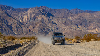
First though, we had to make the short trek back to Saline Valley Road. As two easily distracted explorers, even short distances are never easy - and this time was no exception. First, there was this perfectly good Bridgestone tire that looked a little rough around the edges, but surely would have gotten us where we needed to go.

And then, there were burros. Yeah, I know they're generally more of a pest in this area - and I've sworn more than a few times when they've woken me up with their confounded bleating during the night - but that never seems to us from getting excited whenever we see them.

Eventually however, we did make it to Saline Valley road, the Inyos rising majestically behind us - towering 10,000 feet above the valley floor.

In crappy condition as always, the washboard corrugations made travel a royal pain - and the only way we could bear it was to keep the speeds up around 45mph. Thank goodness for the ADS suspension (front|rear) - I'm sure it got a good workout on this trip.
Soon enough, we found ourselves high in ███████████████████████████████████████ the Inyo Mountains. This was a spot that I'd fallen in love with as soon as I'd seen a a trip report from Ken @DVExile, and I'm happy to say that it didn't disappoint.
We arrived just as the sun was setting, a purple hue cast over and area we'd spent the last two days exploring.


This, our last night before a two-day trip home, we took our time - enjoying the light as it played across the landscape, taking in familiar sights from a new perspective.
Not that it was late by any stretch. With sunset at 4:36pm and last light at a mere 33 minutes later, even as we set up camp and started cooking dinner, we knew we'd be eating well before we'd usually even discussed what we would be having for dinner at home!


No, we didn't have spam sandwiches; we had ramen! Actually, it was quite tasty - and the warmth was a nice contrast to the cool air at our higher elevation.
With dinner done and another packed day in the books, we climbed into bed to cozy up under the comforter, another clear night with bright stars and a nearly full moon revealing itself above.
Though it was our last night, we had plenty in store for the next day before we had to turn the truck north - elements of which each of us were looking forward to as we drifted off to sleep.
The Whole Story
![In Search of Overlooks - A Fall Trip to Western Death Valley [P1]](https://live.staticflickr.com/65535/49072602511_82aa16d541_h.jpg)
![Old Roads and Star Trails - In Search of Overlooks [2]](https://live.staticflickr.com/65535/49082756533_26e5373a5b_h.jpg)


")
")
")
")
")
")
")
")
")
")


")

")
")
")