
Perched on my little knoll in the middle of the road, I was happy that the night passed mostly windlessly so I could get some much needed sleep after the last couple of nights where I got almost none. Having gone to bed with clouds in the sky, but with a forecast of clear skies each day, I hoped that morning would bring a beautiful sunrise, followed by clearing. As such, I was up way too early.

Light on the horizon, but way too early. Shouldn't have gotten up.
My alarm - set for a Pacific Time sunrise, rather than Mountain Time - got me up more than an hour before I needed to be down the ladder, so after a few shots I headed back under the covers for a few minutes.
Likewise, when I looked up and saw some color, I closed my eyes for just a few more minutes. Except that it was a few more than a few more. 
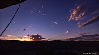
Nice color. Should have gotten up.
Having made the "no breakfast" mistake the previous morning, when I did climb down out of the tent after the sun was completely up and over Comb Ridge, I prepped a big bowl of cereal - enjoying it as I looked over the landscape; wondering what I should do first on this beautiful spring day.
The answer - obviously - was first to get down off this crazy trail to Hotel Rock, so after stowing all my gear, I gingerly made my way down the trail.

Easier when you're not worried that your front skid is going to fall off because it's missing two bolts.

The easy part.
I always find downhill more difficult than up - I think because I can't see the obstacles and drops as easily over the hood in that direction - so I was glad to be down with only a few places where I had to get out to spot myself. And now, I had a decision to make - turn north to Monarch Cave, or head south to Arch Canyon?
Ultimately, I figured that the light would be better in both locations if I ran Arch Canyon first, so that's the way I headed - hopefully early enough that I'd be the only one on the - what I was sure was a - popular route.

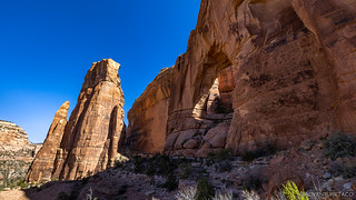
The mouth of arch canyon is choked in Cottonwood trees. Leafless now, they were a beautiful silver.
Note: Visiting Arch Canyon requires a pass. For more information, check out BLM Utah Cedar Mesa Permits and Passes Information.
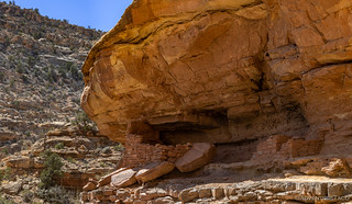
None of the road up Arch Canyon is particularly difficult, but the entire length twists and turns up the valley, slowing what could otherwise be a very fast trail. I was ready to take it easy anyway, and not far from the mouth of the canyon I pulled to the side of the road for the first of a dozen or more stops: Arch Canyon Ruins.

Protect and preserve for future generations.
Being signed, these ruins were predictably in pretty bad shape - try as we might, humans have a hard time with the concept of protect ad preserve. Still, it was fun to imagine what this site must have once been, the towering wall of sandstone providing protection for a small village below.

The largest ruin. The hole in the wall used to support a log that spanned the interior and supported the floor of a second story.

A circular structure, nearly gone.

I really liked the stripes on the sandstone.

A long, low structure with many footprints on the walls themselves.
In addition to the ruins, this site also contained several petroglyphs etched into the sandstone wall. These ranged from geometric shapes to wonderful handprints, though - predictably there were also several modern scratching's as well.

Owl eyes.

Spirals.

A family?
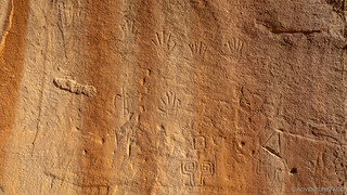
Notice below the handprints - the sandstone has been smoothed by modern visitors, destroying the glyphs. Then, someone etched in new markings. Classy. 
From the Arch Canyon Ruins, headed back to the truck and pointed myself up canyon. Despite my disappointment around the state of the ruins, I was actually having a great time - extremely glad to have the canyon to myself, and happy that I'd opted to come this way first thing in the morning.
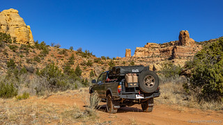
Winding my way through the stone monuments.
As I made my way north - always my preferred direction of travel, since it puts the sun at my back - I found myself constantly craning around the cab of the truck, peering up at the cliffs in search of more ruins. Surely, in a location such as this, the marked ruins near the mouth of the canyon were not the only ones to be seen. Soon, my attention was rewarded as I spotted a line of cliff dwellings along the wall to my east. Thankfully, these - and all the remaining ruins I found - were unmarked, saving them from the destructive forces of UTV drivers. I got out to explore.

Just above the treeline, I spotted a well-camouflaged row of ruins.

A round "guard house" at the point.

I thought it was interesting how the outer wall was (more) rock, and the side wall was (more) mud.

Layers of light.
After poking around the ruins for a while - initially looking for a way up, and then realizing that the perspective from the ledge wouldn't be as good as from below - I wandered back to the Tacoma to continue my winding journey up the canyon. I was still early enough in the spring that there was a bit of water in the creek (river?) and I seemed to cross it continually as I followed the road from one side to the other.
Then, I saw it. High up on the wall - inaccessible without significant effort. I grabbed the binoculars for a better look.

Jailhouse Ruin.

Closer.
So named - obviously - for the wooden posts in the opening, this is a ruin that I'd love to visit again in the future. I think I've discovered a hiking route that would allow me access to the ruin, which would be fabulous to photograph from the interior. For now though, I continued on, the draw of the remainder of the canyon too great to sidetrack myself for what would surely be a several hour side-journey.

Oh look, another creek crossing!
After maybe another mile, a small granary nestled in an alcove of the 260 million year old Cedar Mesa Sandstone. I think many of the structures we see today were actually granaries - ancient Anasazi storage facilities used to store surplus harvests (mostly corn) for lean periods.

Ancient granary.

No longer a granary; now a home.
With my head on a swivel and all the resulting stops, I wasn't making record time up the canyon. In fact, at this point I was only about halfway up the road, and though it was only 9:00am, I reminded myself that I had a full day of exploring after this canyon, so I should really get a move on.
As if that would make any difference in my speed.

Guess what?! Creek crossing!

Sorry for disturbing you, ducks.
As it turns out, I didn't see many more ruins on the second half of the trail. Only one more set caught my eye - built into a crevice high on the walls of Mule Canyon. Like the Jailhouse ruins, I'd like to return and hike to this set - a several hour journey for sure - on a future visit.

Can you see them? Discovering the path to the Mule Canyon ruins would be the most exhilarating part of their exploration.
Despite not seeing more ruins, it took an hour to complete the second half of the trail, and it was 10:00am when I parked the truck at the foot trail that continued on to the arches that gave the canyon its name. In fact, I could see the first arch - Cathedral Arch - from the parking area, and it there was no doubt as to the thinking behind its name.
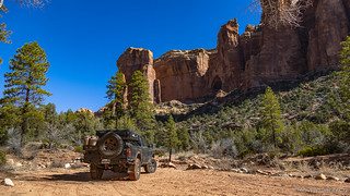
End of the road. Now the real fun begins!
As I headed up the main trail, I soon realized - like the road had been to the ruins - that the trail wasn't going to lead me to the arch; rather to a viewpoint of the arch. This - for me - was unacceptable! A quick look at my topo map, and I determined what I thought would be the most likely - and perhaps only - successful route to the arch before breaking away from the main trail to bushwhack my way up.

I knew the only way to see daylight through the arch would be to get much closer to it. And I love a challenge!
500' of elevation gain later, I'm sweaty and closer, but not there yet.

Success?
The hike up to Cathedral Arch had been fantastic. A little tracking of those before me, and some route finding when the trail got too faint to follow - the thrill of discovering a ramp up the sandstone here, a crevice I could inch up there - it was great fun and made me glad I'd decided to give it a go.
Still, I could tell that looking into the cathedral from the outside wasn't the pot of gold at the end of this journey. The real treasure - if it was achievable - was going to be looking out from the inside. And that meant I wasn't done yet!
I set about finding a route through - though the solution ended up being around - the arch.

Making my way around, grand sandstone columns rising high around me.

Jackpot!
Awe would be the best way to describe the feeling I had as I lingered there inside the cathedral, looking out its arch. Clearly such a reverent place, I found myself expecting to find some Native American dwellings or rock art on the walls around me, but while they surely found the place inspiring many hundreds of years before me, they must have enjoyed it the same way I did - looking out onto Arch Canyon and the wonders it held.

All alone in this moment.
Having slowed down enough to enjoy myself, it was time to get myself back down to the main trail and on my way to the second - and last that I knew of - arch: Angel Arch.
And, while my route down was significantly easier - I was simply following my own tracks - it was no less eventful. Just a few minutes into my descent, a manzanita branch snagged my favorite pair of pants and gutted them before I could slow my momentum.

Hrm.
Bummed - since it seems like all the camo cargo pants these days are skinny fit, and I'm more of a relaxed fit kind of guy - but recognizing that they are just pants, I plodded on - down to the main foot trail and then onward up the canyon. I must say, it was warming up, and a little extra air circulation through my leg region was actually quite nice.
It was a mile or so before I caught my first glimpse of Angel Arch, rising in the distance.

Guarded by an Angel.
Like Cathedral Arch, the trick here was going to be finding the right angle to see blue sky through the sandstone structure. Even harder this time would be capturing both the blue and the angel at the same time. Still, I hoped it was possible as I made my way nearer.

Closer.
Ultimately, I never found the perfect route up - though, it was likely for lack of trying. Having eaten a granola bar before setting off, my stomach reminded me that I'd already scaled this canyon wall once, and a glance at my phone suggested that spending a couple more hours doing it again probably wasn't in the cards for today.

I settled for a little blue.
As I headed back toward the Tacoma, I took solace in the fact that - especially from the other side - the arch's angel wouldn't have been visible at all, so I wasn't really missing that much. Or at least, I tried to convince myself that was the case as I made good time down the main trail.

Warning, math joke: Square root.

Mmmm, that truck means lunch!
By now, it was 11:30am and while I was definitely hungry, I opted only for an apple and some chips before starting back down the canyon. My thinking - flawed as it may have been - was that I could make my way out before too many folks (UTVs) started up the road toward me, and then I could eat lunch on my way to the Monarch Cave.
Of course, in reality, the UTVs were already on their way and there was no way I wasn't going to stop for a previously unnoticed ruin on the cliff side - so my lunch would just have to wait.

Striped sandstone near kitchen ruins.
Well protected kitchen ruins.
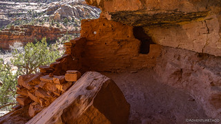
The kitchen. Soot on the ceiling.
Turns out I made pretty good time down canyon, reaching the mouth a little after 1:00pm. A final look at the stripes of Arch Canyon Ruins and I turned myself north.

The elusive tiger sandstone.
Little did I know that my fabulous morning would be completely overshadowed by the afternoon's activities!


Similar to the old homesteads of the desert, this makes you wonder how they ended up here and all the work that went into building their home place. Very resourceful people and hard workers. This is a place I would love to see along with the mighty 5 parks.
Again, great photography!
Thanks Kenny! It is amazing to see what's left of these ancient civilizations and to think about the life they lived. Some of the ruins seem so inaccessible now, but were likely positioned strategically for defense, etc.
One thing is for certain - I have yet to find one that didn't have amazing views. Clearly, these early inhabitants valued the same beauty we do, ad did the early homesteaders! It's always been about location, location, location. ?
Amazing trip report and photos. I traveled the Comb wash road to the west of Comb ridge and missed all the amazing ruins and petroglyphs that are up Butler wash to the east of the Comb ridge. So, I'll definitely need to travel the Butler wash next time. I had read on one site that 'permits' are required from a BLM office to hike to the sites. I certainly didn't know this when I traveled the Comb wash, and was wondering if you had any knowledge of that requirement? I'm going to recommend the Butler wash to my brother who is headed out to Utah in June.
Hi Lapsely, passes (or permits, depending on the destination) are required for hiking in this area. The passes help to find upkeep, and the permits keep the number of visitors to sensitive sites to manageable numbers.
More info on the passes and permits necessary can be found here: BLM Utah Cedar Mesa Permits and Passes Information.
It’s a great thing to be aware of, and I’ve added it to the post as well. ?