
Heading out of Atlantic City, we were both looking forward to a leisurely stroll around the ghost town of South Pass and the nearby Carissa Mine. I actually envisioned them as similar to - but perhaps better than - the amazing ghost town of Bodie, California, which I'd visited the previous fall.
As we approached, it was immediately clear that SOMETHING WASN'T RIGHT.
We'd felt that Atlantic City had been crowded, but South Pass was something else entirely. Above the town, an entire hillside had been converted into a parking lot, and hundreds of vehicles - of all types - were lined up in neat rows, attendants in orange vests directing new arrivals into position. Glancing to my left - and several hundred feet before the stadium-sized parking lot - I noticed that the parking area for the Carrisa Mine was nearly empty. Perfect, I thought, as I started to pull in the driveway.

The Carrisa Mine.
It was just then that @mrs.turbodb mentioned it was closed, and we saw an orange-vested-man jogging over from his UTV he'd been sitting in nearby. Getting so close to my open window that I felt as though he was Dukes of Hazzard-ing it into the Tacoma, he let us know that only volunteers could park at the mine. As such, we would need to make our way down to the lot and then either walk back over or ride one of the busses that left every 15 minutes.
As I saw @mrs.turbodb nervously grabbing at her door handle to give herself a bit of room from this overly-friendly fellow, I agreed as quickly as possible so as to get him out of both our personal space.
On reaching the parking lot - and with a bit more breathing room - another orange-vested volunteer asked us if we were here for "Gold Rush Days." We must have looked confused as we said no, because he launched into a spiel about transportation to/from the lot, the fact that there were food trucks in town, and most importantly, that a 70lb anvil was launched 70-feet into the air every hour, on the hour.
We thanked him, and then made a sweeping u-turn in the lot. This was not our cup of tea.  We never did get to see South Pass, and we were going to need to find somewhere else to eat.
Luckily, we found a shady powerline road not far out of town, and after enjoying our sandwiches in the shade, we turned north into beauty of the Wind River Mountains.
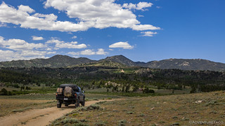
After driving across high desert in the previous stage, it was so nice to get into the mountains again!

The mix of rock and vegetation was just perfect.

As we crested the first set of foothills, the higher elevation - and increased water - were immediately apparent.
Winding our way along the graded gravel road, we remarked to each other how much traffic there was on this section of the trail. Initially we chalked it up to the Gold Rush Days, but then @mrs.turbodb started wondering, "Where is everyone coming from?" She couldn't believe that they'd travelled some 40-miles from Lander, but sure enough, that's where they'd started!

Shortly, we passed the sign for Christina Lake - a place I'd hoped to camp when I'd planned this trip, but we ultimately decided to hold off on until a later time.
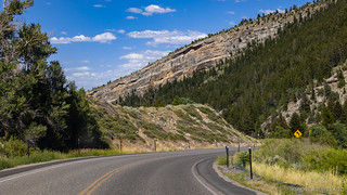
Despite the traffic we pushed on, and only later did we discover that this part of the route is always busy, the BDR site even warning riders that, "This section on Forest Road 300 is one of the highest trafficked sections of the WYBDR so go slow and watch for vehicles on every corner, and Ride Right." Boy, they aren't kidding.

Even with all the traffic, we did find some spots here and there where we just couldn't resist stopping.

Louis Lake, not to be confused with Louis Lane.
Along this route, Blue Ridge Lookout - built by the USFS in 1938 sits at the crest of the ridge, and is accessible via a half-mile hike or a three-quarter-mile 4WD road. Even with slightly lower temperatures at these higher elevations, we knew better than to set off on foot, and soon we found ourselves as the sole vehicle parked at the lookout.

Probably not suitable for the Tesla.

I must admit to getting a kick out of seeing the look on hiker's faces as they saw our truck parked in the meadow after they had hiked up the hillside.
There are two granite outcroppings perched along the ridge, and with the old lookout full of people, we quickly decided that it would be fun to boulder our way up the other. This turned out to be a great decision, as it allowed us to get a better view of the lookout - and its fabulous staircase - than if we'd climbed the same way that everyone else had.

Stairway to heaven(ly views).

Living pictograph. Lichen on granite.
It was so windy at the top of the outcropping - understandable I suppose given our location in the Wind River Range - that I asked my companion if the rocks themselves were moving. She assured me - with perhaps the same chuckle as those reading this story - that they were not. Still, with such strong gusts, there wasn't much we could do up there, so we made our way down - first to the truck, then to the main road - and continued along our way, the road eventually turning to pavement.

Down we go, toward Lander.
Before reaching Lander, we had one more stop to make: Sinks Canyon. This is a place where the Middle Popo Agie River disappears into a cave in the mountainside, only to emerge again a quarter-mile further down the canyon at a spot known as The Rise. Interestingly, the water takes two hours to make the journey, and more water surfaces at The Rise than disappears at The Sink. Where the water goes for those two hours is still a mystery, but we do know that the sinks are likely an ice-aged feature that were created when channels in the soft Madison Limestone formation eroded away.

It is rather disconcerting to see water flowing at 100 cubic feet per second, just disappear.
Our final push to into town.
In Lander, we had a few things to take care of. The first was fuel. Our last fill-up had been in Alcova - more than a stage and a half earlier. With 15 gallons in the Scepter military jerry cans, we still had plenty of gas, but the main tank was getting pretty low. Additionally, @mrs.turbodb hadn't been feeling 100% for the last 24 hours or so, and though she wasn't sure how she might have caught it, she wanted to pick up a COVID-19 test to make sure that wasn't the issue. Lastly, we wanted to grab a pair of gloves to replace those that had been lost somewhere earlier in the trip, since taking boxes out of the truck bed in camp can be tough on bare hands. Oh, and we wanted to pick up some mustard, which we'd run out of the previous day.
Luckily for us, all of this was relatively easily done at a combination of Safeway and Mr. D's Food Center, and soon we were on our way out of town.

Good news!
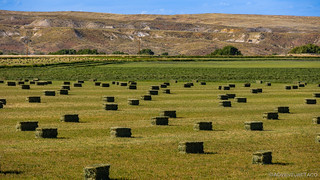
More Wyoming hay. Rectangular this time.
Pretty sure that we wouldn't make it all the way to Shoshoni before needing to find camp - it was just after 6:00pm when we were pulling out of Lander - we soon realized that we were in much the same predicament as the previous evening; perhaps slightly worse. Our elevation here was just over 5,000-feet, and once again there were few-to-none trees to be found. Knowing we could cover a lot of ground in two hours - depending on the roads - we pressed forward, hoping for the best.

Headed into the Wind River Basin on our way to Shoshoni.
We made our first stop at the Rainbow Cliffs. Striped sandstone reminiscent of similar geology in Utah, the road wove in and out of the slowly eroding spires, each rainy season sure to bring new views never before seen.

Rainbow Cliff sunstar.

Suspended stone.
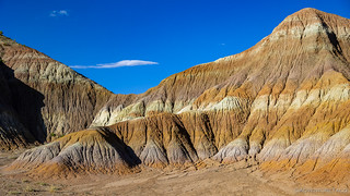
Rainbow badlands.
Leaving the cliffs behind us, we knew that the next section of trail was not going to be a place we wanted to stop for the evening. In fact, even if we hadn't ready the BDR description - "...this section and goes right through a gas plant on the public road... It feels strange but ride on through (if the lights aren’t flashing)." - I think the sign warning us of toxic gas release was probably enough to keep us moving. In fact, I could tell that @mrs.turbodb was even a bit nervous as I stopped to snap a few photos.

Move along, nothing to see here. And move quickly if the lights are flashing.

One of the few gas plants bisected by a public road.

Extraction enabler.
For a moment, things turned a little greener once we exited the gas facility and joined WY-135 for a few miles. Still rising and falling in the 5.500-foot range, it was still toasty warm - though a nice breeze was blowing across the valley, and we knew we had to start looking for somewhere to camp. Luckily, I realized I might have just the place.

Open road.
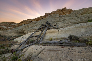
Prior to leaving on any BDR, I always try to inspect the route for nearby attractions, and in this case I'd found an old Uranium mine that I thought would be cool to check out. It was just off the route, and at the very least I hoped that whatever hillside it was carved into would provide shade from the evening sun. Assuming that is, it was carved into a hillside.

Even if we didn't find the ████ Mine, these bluffs sure looked like an interesting spot to camp - and explore!

Well look what we have here....
It turns out that like many Uranium mines, this one had been sealed off with concrete after the extraction was complete. Even inside the steel door, a second concrete wall made exploration of the shaft impossible.
That didn't matter to us though, as we found a shady spot to set up the tent and get going on dinner. The sandstone into which the mine had been bored provided plenty of shade and a bit of shelter from the 30mph winds - something we'd be thankful for once we climbed into the tent. And with that, it was time for taco-rittoes!

As we were setting up camp, I noticed this absolutely perfect little succulent. It was the only one around!

After dinner, the breeze helped to keep the mosquitoes away, and we were able to enjoy the mellowing of the sky around us before climbing into the tent for some shut eye.
The Following Morning...
To our dismay - and this isn't something I say very often - the wind died down as soon as we climbed into the tent. It was strange, really, though perhaps it's normal in Wyoming, even on the Wind River Plain. At any rate, it made for a warm night, one where @mrs.turbodb resorted to a damp bandana laid over her body in order to keep her cool. I - on the other hand - wasn't so smart!
Still, by the time we awoke, temps had dropped into the low 70s °F, and it was quite pleasant ouside the tent. I took some time to look around and snap a few pictures of the area - things we'd looked at the night before, just after I found that my camera battery was dead.
An old loading structure that was once anchored into the sandstone, the sun rising behind.

A sandstone outcropping, caught by the morning rays.

Our favorite camp site so far.
Nestled in the sandstone, we'd been shielded from the sun - even after it'd risen over the horizon - but we were still out of camp early to take advantage of the cooler morning temperatures. Exiting our spur, the warm golden glow over the green grass on the hills was a great way to get going and soon we were headed towards Shoshoni.

I've said it before and I'll probably say it again - we timed this trip perfectly.

Back on the trail, we made good time on the well-groomed gravel.
We'd covered most of the stage as we looked for a camp site the prior evening, leaving us only about 20 miles to cover before being one step closer to the Montana border. Through an oil and gas field - the second of this segment - those miles ticked away uneventfully, and soon we were searching for Shoshoni's water-jet-cut welcom sign.

An old derrick, abandoned in the field, its generator and storage tanks pilfered for a well that is still producing.
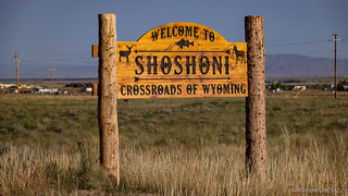
Welcome to Shoshoni, where we never did find the prototypical metal sign. (I like this one better!)
We hadn't expected much from this stage, as it made its way through the Wind River Basin. We'd figured it took one of only a couple paths from west to east - around the Wind River Reservation, setting us up for a run to the Bighorn Mountains. Still, besides the surprise at South Pass, I think the route had surprised us both. Be it the toxic gas warning signs or our fantastic camp at the uranium mine, this stage had certainly left an impression on us.
And, we had no idea at the time, but we'd soon feel as though we'd left Wyoming entirely!
The Whole Story


Love Backcountry Discovery Routes? Check out
BDRs we've run
to find your favorite.


")
")


")
Too bad about South Pass. I really hate crowds and do as much planning as possible to avoid them. On one trip to Randsburg we were unpleasantly surprised to find it overrun with ATV's, evidently some kind of gathering so we just continued on having to forgo a nice ice cream sunday at the old general store.
Was a bummer, but eventually I want to head back to the area to explore a couple lakes, so we'll try to hit up South Pass then - mid-week and in the off-season (fall, likely). Even with the crowds there though, it was a pretty fun section of the BDR, and finding the mine to camp at was pretty awesome!
Thanks as always for the comments; I love getting them! ?
We have the Mojave River here. It's mostly underground but comes up in one area and then goes back underground.
Ah yes, the Mojave. Many fun trips around that river (I esp. love Afton Canyon). The thing about The Sinks - compared to the Mojave - is that a rushing, roaring river just flows into a cave and disappears (whereas the Mojave sort of seems to "slowly absorb into the ground").
Next to the cave where the river disappears is a completely dry riverbed. During the height of spring runoff, the cave can't handle all the water, and the riverbed becomes the overflow.
Yep, that is pretty unique, would like to see that. And yes, Afton Canyon.