
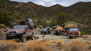
I think the night we spent in the Panamints was the most peaceful of the trip. Sheltered from the wind, our high elevation resulted in cool temps - always better for sleeping in my book... to an extent, anyway.
Having arrived at dusk the night before, none of us had a chance to look around our camp site before it was too dark to really see anything. So, though it was cloudy, I was up and looking around relatively early the next morning.
As with the previous morning, it was just before 9:00am when we rolled out of camp. Headed down Wildrose Canyon, a family of burros greeted - and then trotted along beside - us as we descended to the main road.

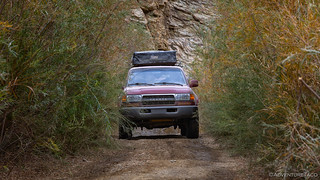
From Wildrose Canyon Road, we headed south, Hugging the base of the Panamint Mountains along the east side of Panamint Valley, we covered the 15 miles to Ballarat in a little over half an hour. Once again, dust was our enemy, forcing everyone but me to slow down and hang back. Even so, there were several sections where I heard Mike on the radio letting us know that visibility was near zero as he felt his way along the road.
 . Today however, a weary traveler can call it home for an evening, assuming no one else has claimed it.

I was very much looking forward to the next portion of the trip. As the organizer - and person most familiar with Death Valley - nearly everything on our route was somewhere I'd already been on a previous trip - after-all, I didn't want to bore my good buddies to death with something mediocre. However, the route up Pleasant Canyon to Rogers Pass - and then back down to Panamint Valley via Middle and Lower Parks - was new to all of us, and that got me excited.
Excited, and a bit worried, since I wasn't really sure how long this 30-mile loop would take, and it was already 10:00am!


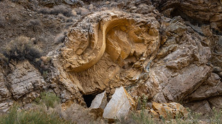
Initially, the route up the canyon was alternately choked by brush and bordered by rocky canyon walls. Unusual for the desert landscape we were exploring, Pleasant Canyon has persistent springs at several spots up the canyon. These help to keep water flowing all year round and were certainly advantageous to the mines that once worked the nearby hillsides - remnants of which we stopped to peruse along the side of the road.

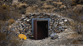
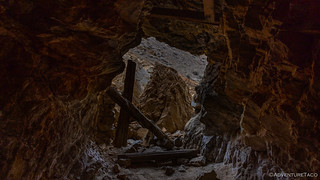
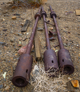
After making our way about halfway up the canyon - passing several spur roads that I'll have to go back and investigate in the future, as it seems I could explore for nearly a week in this area (!) - we found ourselves at a large mining site - the old Claire Camp gold mine.
We weren't, however, alone. Two guys in an ATV - and one more in a full-sized pickup - were at the site already, and I thought they were actively working the ground for gold. Hopping out of my truck, I approached them cautiously and asked if they were mining the area, and whether they would mind if we looked around. Turns out, they were there as contractors for the BLM, and rather than mining, they'd been hired to clean up the site as part of an ongoing restoration effort for the canyon. As such, they had no problem at all with us poking around, so we maneuvered our trucks to the side of the road and gave ourselves the nickel tour.
In 1896, Henry Ratcliff began working his Ratcliff mine in the hills above Pleasant Canyon and pulled approximately half a million dollars' worth of gold from the ground over a 5-year period. To achieve this, nearly 200 miners worked the mine and a town - complete with a Blacksmith, and assaying office -spring up in the narrow canyon. Ultimately, this was too large a population for such a small area, and the town was abandoned - along with Ballarat - in 1901 due to large gold strikes in Tonopah, Nevada. Subsequently, W.D. Claire - hence the name "Claire Camp" - bought the Ratcliff mine in 1930 and worked the tailings successfully bringing out another $60,000 in gold ore.

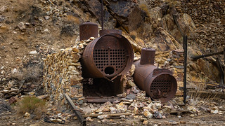

The camp was a strange mish-mash of old and sort-of-new. The mill, boilers, and much of the mine equipment clearly dated back to the original working of the site, but there were also newer RV trailers and a semi-refurbished cabin that must have been less than 50 years old. Our hope was that these newer items were what the BLM-hired cleaners were here to remove, and that the historic bits of the mine would remain for future visitors to admire.


After wandering around Claire Camp for half an hour, it was time to move on. We'd only scratched the surface - I knew that I could spend an entire day poking around these parts, exploring adits and admiring old structures - but the rest would have to wait for another time... we had lots more ground to cover before the day was done!
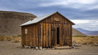
So, naturally, less than a mile up the road - we stopped again.
This time, it was a solitary cabin that caught my eye. Pulling into the parking area, it was clear that this one was still actively maintained, and we'd soon find that it was the cabin for the still-registered World Beater Mine. Yet another area to come explore in more detail on a future trip.


It was noon by the time we finally pulled out of the World Beater Mine, and I at this point I knew we had a time problem. The entirety of the road up Pleasant Canyon was 11.9 miles, but in two hours we still hadn't made it to the apex at Rogers Pass. With another 13.6 miles to go down Middle and Lower Parks, lunch to be eaten, and Goler Wash to be traversed before reaching camp - well, you can see where I'm going. We needed to get moving.

It was chilly - and windy - up along the ridge. Though it was already after lunch time, we pushed onward in search of somewhere a little more sheltered to break out our camp chairs and sandwiches, to satisfy our hungry bellies. As we did, we were treated to some fantastic views of Butte Valley from a perspective that I've never seen before. For me, it was fun to look down on where we planned to camp for the evening - though it turns out that even I had no idea what we would go through to get there!

Now headed back down, we passed through Middle Park - a large, "mountain meadow" if such a thing can exist in the desert - nestled high in the Panamints and dusty as could be. High speeds and good spacing meant we didn't spend long there before crossing into Lower Park and finding a place to pull out our chairs in the shelter of some pinyon pine.


It was 1:00pm when we finally stopped for lunch, with a view of Lower Park stretching out before us. We ate quickly - or more quickly than normal - as I related the remainder of the trail we had in front of us to the rest of the guys. I suspected that we'd mostly speed back down the mountains to Panamint Valley. A little further south, we'd head back into the same range - stopping as we could at a few mine sites and the Barker Ranch - on our way to camp in Butte Valley. We'd arrive, hopefully, just before dark.
None of us realized at the time, but the next three hours would most definitely not go as planned; they would in fact spell the beginning of the end.


A big part of the reason we'd run this trail was because I'd read through one of Mike's trip reports where he mentioned a section of trail that was once a sketchy wooden bridge but had recently been replaced by the BLM. Even if it wasn't nearly as dangerous as it once was, seeing this section of road seemed like it was a worthwhile activity, and as we turned a corner to a rocky, shelfy area, I wondered if we'd come upon the spot.


It turns out that this wasn't the section that I was thinking of, and so we continued down to the only part of the trail where I hopped out of the truck in order to walk the trail before driving. A spot where the road narrowed, and a shelf on the up-hill side suggested an off-camber turn with a hundred-foot vertical drop off the passenger side.
And this is where I made a mistake. It looked to me that a 1st gen Tacoma - one of the narrowest vehicles on the road - could just squeeze through the turn on the downhill side of the ledge, avoiding the off-camber section. So I started into the turn, waving off any spotting from my buddies behind.
Smarter than me - or perhaps just hoping to snap some photos - Monte hopped out of his truck anyway, and as I inched forward, I suddenly heard him yelling to turn my wheel hard driver. "You're going to drive off the side of the road," he yelled as I stopped the truck.
Well, then, that wouldn't have been good.

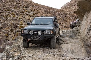
Ultimately - with a bit of maneuvering, I was able to get the truck onto the correct line, and squeaked through unscathed. Barely. While this could have been the beginning of the end, it wasn't. Not yet.
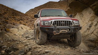
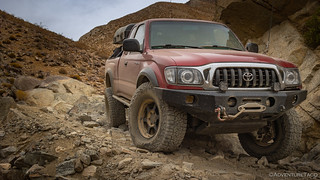
Next up, Mike made the whole thing look easy as the Redhead flexed in all the right ways.

Mike kept his driver tire on the uphill ledge, right where it was supposed to be.
Having provided all the drama we needed, the remainder of the trail was completely uneventful, and a few hundred feet beyond the turn was the metal-reinforced ledge that was apparently once a wooden bridge.


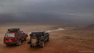
Finally, we exited the mouth of the canyon and were deposited onto the wrinkled alluvial fan. The views here must be spectacular on a clear day, but it was hard to complain about the rare experience we encountered - rain storms coursing through the valley below.

By the time we reached the valley floor and headed south toward Goler Wash, it was 2:45pm in the afternoon. With less than two hours of daylight left - and 15 miles of rocky trail, with numerous mines and places to explore before camp - I knew we'd be rushing a bit more than ideal.

Heading up the wash, I pointed out various rock formations, interesting spur roads, and abandoned old mines I'd hoped to explore. Light fading fast, we pushed on past each of them, radio chatter assuring me that it was OK - just another good reason to return in the future. It made me think back to my first time at the park - when I'd travelled a similar route with similar constraints. Less than a month later, I'd come back - to spend nearly an entire day in this canyon. It was a good reminder that rushing through Death Valley is a common mistake!

The Barker Ranch - built in 1940 by Bulch and Helen Thomason was originally used to support their mine in the area. It was later acquired by James and Arline Barker in 1955. Working nearby gold and uranium mines through the 1960s, the ranch was also a seasonal vacation property for their families.
It wasn't until 1968 that Charles Manson learned about the ranch and began staying there with the Family. Eventually, suspected of vandalism further north in Death Valley National Monument, the group was captured in raids on October 10 and 12, 1969, with Manson himself caught hiding under the kitchen sink. At the time of their arrest, law enforcement was unaware unaware that they had captured a mass-murder and his followers.

Having completed our only stop between Panamint and Butte Valley, we pushed forward over Mengal Pass and into the valley we'd call home for the night. Our route winding its way north, the rain had picked up again by the time we reached the final descent into Butte Valley, and we mostly remained in the trucks through the roughest - and most fun - sections of the trail.


It was during the final descent that I first heard a strange noise coming from what I thought was my transfer case. Hoping I was wrong, it seemed intermittent in 4-Lo, and sounded - to me - like grinding.
Letting the guys know that I needed to check out a noise, I crawled under the truck, hoping to find a loose bolt and a flopping skid plate as I have in the past; unfortunately, everything was tight. And, by the time I climbed back out from under the truck, all three of my buddies were standing by - ready to lend a hand with whatever the problem might be.
The consensus - based on my description and from guys who knew more than me - was that either one of the planetary gears in the doubler portion of the transfer case might have lost a tooth or that the j-shift bushing was worn out and so the shifter was rattling around in the case. And, while either of these could eventually cause a problem, it would probably be OK to continue for the remainder of the trip.
I hoped they were right, and we rolled onward toward camp - a little spot that both Zane and I had camped previously; a spot that - assuming the rain stopped - I knew would be the perfect place to wake up in the morning.
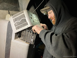
For the second night in a row, we arrived in camp after sunset. Luckily, the rain mostly stopped about an hour or so after we got set up, and we were able to enjoy the propane fire ring for the remainder of the evening. Plus, about 90 minutes into working on his fridge - having tried new fuses, tightening of screws, and reseating of terminals - Monte figured out the problem: he'd had the fridge turned off! 

If only the solution/situation had been the same for my transfer case - alas however, as I'd discover in the coming hours, it really was... the beginning of the end.


Ahh yes, Chicken Rock...! We've gone UP that part of South Park twice. And our general approach is to hug the outside -- right near the ledge in full pucker effect -- because that one sentinel rock loves to eat CV's and such. Great read! And good job for leaving out certain details!
Oh, and I'm pretty sure those are Willow's in the wet spots...?
--Paul
Glad you enjoyed the story Paul! Left out some of the details mostly due to the rain and the fact that they were already spoken for as we passed, ?.
Was actually considering going back to explore the area more. Thought I’d go up South Park this time, but perhaps I’ll go the same direction if going up is significantly more difficult. I don’t recall seeing a rock that would have made it tough, but I’ll be a single truck this time, so better to be safe in a situation like that!
Was that yet another Maddog stove (#3) Same kind of cursive as the 2nd one? UJ
This was the same stove as #2 that I sent you, just that I'm only now (a few weeks later) getting to posting up the story for everyone else to see. I'm still on the lookout for a #3 though - and hoping to be back in the general area, looking at some more old mine cabins - pretty soon here!
Thoroughly enjoying your travels!
I own a stock full size GMC Sierra Denali and do like Death Valley and The Mojave Rd. Two places I've explored so far. But you go places I don't think I'll try!! My truck is to big and my daily driver...
So again, thank you for documenting your travels! And don't mind me... I'm the ghost sitting in your passenger seat... enjoying the ride!
Stay safe, be well.
David
Hi David, welcome to my passenger seat! Nice to hear that you're enjoying the stories, and that you've gotten to experience Death Valley and the Mojave Road in person - not a lot have, and I think they are wonderful experiences. I always say that our vehicles are generally more capable than their drivers, so I'd say to keep on getting out there an exploring - you can always turn around if you get uncomfortable with the terrain. There's plenty in Death Valley and the Mojave to explore as long as you are careful to not get in over your head! Have fun and stay safe out there as well! And I love getting the comments when something strikes you just so! Cheers, Dan
Fantastic job on the series. Great pictures and narration. Keep it up
Thanks Mark!
Great story, can't wait to hear what's on the other side of the transfer case cliff hanger 🙂
I drive a 2020 Power Wagon and couldn't find the courage yet to do the Pleasant Canyon/South Park Canyon loop. What do you think about driving a full size truck through there (on 37s but wide).
Hey Jupp, I think that going up Pleasant Canyon would probably be fine. Coming down (or going up) South Park would be tight for sure. You'd certainly want a good spotter or two at Chicken Rock and along the ledge road there, if you were going to attempt that section of trail. And, I'd say that down would be easier than up. Hope that helps!
Excellent read! You definitely passed up some treasures on this day, such as the furthest SE section of South Park road to the Striped Butte overlook, and Briggs Camp.
Thanks Curt! I know I missed some great stuff up there - but never fear, I'm fixing to change that shortly! ?
nice to see you have added a series 80 on this trip.