
Having just completed the Nevada Backcountry Discovery Route (BDR), we now found ourselves in at the southern most tip of Nevada, quite a distance between us and home. We found ourselves there with a week to spare, having finished the trip a few days sooner than we'd originally expected.
Only the timing was unplanned however, as we'd run the BDR this direction on purpose. By doing so, we hoped that we could meet up with Pops on our way home at the same spot we'd spent a few days with him just a month before. Well, as it turned out, he wouldn't be able to make it, but that didn't mean we couldn't go enjoy it ourselves for a few days, relaxing and exploring the area to our hearts content.
Under a full moon, we headed west along I-40 until we reached the old train town of Essex, California, just south of the Mojave National Preserve. Here, we setup camp in the dark, made dinner at something like 10:00pm, and shortly thereafter hit the sack - our last day on the BDR had been a long one and we were both pooped!

We woke up reasonably early - around 6:30am the next morning - rested, but already hot. That Mojave Desert sun is no joke - something we'd be reminded of throughout the day - and it warmed us up in the tent to the point where we were ready to get out of there!
As we did, a long Union Pacific train made its way through the valley, the rumble of seven engines only just audible from our position several miles away.


Our first order of business as we got in the Tacoma was to turn on the A/C. Unfortunately, despite having recently replaced the evaporator core, and the system having worked wonderfully for the duration of the NVBDR, it was no longer working this morning - so, it was apparently going to be a hot day. And, I've got more work to do on the A/C apparently.
Soon enough, we found our way onto the historic Route 66 as we headed west. We'd considered spending a day or two in the Mojave Preserve, but with no A/C and temps projected to be over 100ºF each day, we decided it'd be smarter to just make our way up into the mountains where lower temps and shade would keep us much happier campers!

The route west took us through the town of Mojave. Not all that notable - at least to us - except for one thing: as you drive by on CA-58, you can see an airfield filled with old planes - something I've always wanted to check out, but we've always been in too much of a rush. But not this time!
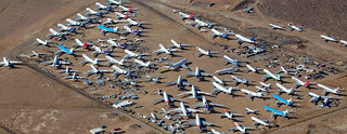
Well, it turned out that the graveyard is only open for tours on certain Saturdays. This being a Sunday, we were not only out of luck, but all the other facilities of the airport were also closed.  We were however able to poke around the planes at the front of the airport however, and those were super cool as well!

This jet was used by NADA's Armstrong Flight Research Center as the Landing Systems Research Aircraft in 1993 and 1994 to flight test space shuttle landing gear and breaking systems. Tests were conducted at Edwards AFB and the Kennedy Space Center in Florida.
Still a little before noon, and with temps having climbed even higher than they'd been in the Mojave Preserve, we didn't spend all that long at the airport once we determined the graveyard to be unattainable - continuing on towards Tehatchapi where we could pick up a can of R134a to at least temporarily recharge the A/C system and pick up some food for lunch. And, on our way there, we hit a truck milestone as well! Hard to believe that it took 17 years to hit 60K miles, 2 years to get to 120K, and only another year to bump that up to 150K!

Our bellies full and the A/C blowing cool once again, we hit the highway and headed north for several hours so we could make it to our camp site before nightfall. Hopefully - given that it was Sunday night - it'd be unoccupied, and we'd be able to enjoy it for several days as we lazied about and went on various hikes in the area.
Heading in via ████████ Road - an alternate route to the one we've taken before - we stopped along the way to admire various discoveries along the way.


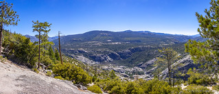
And then, as we got closer to our destination, a beautiful sight opened up before our eyes. This was a perspective we'd never seen before - an expansive view that nearly knocked our socks off!

At this point - though we still had a few hours of daylight left - the sun was starting to get lower in the sky and we figured we might as well pick up our pace a bit, so we'd make camp in time to enjoy a nice sunset. We couldn't resist one final stop along the way when @mrs.turbodb noticed a sign along the side of the road - at this granite bridge named█████████ - which was the perfect place to look over the valley.

From there, it was still a good 40 minutes before we reached camp, our fingers crossed the entire time that we'd find it empty. As we approached however, I must admit that our hopes were waning - we'd seen several cars along the way, the holiday weekend clearly having been a busy one for the area.
Sure enough, even before we arrived we could see smoke rising from the fire ring at the site - our hopes finally dashed. Still, we knew there were several more amazing places nearby, and we were soon setup near our favorite swimming hole, our surroundings even here, hard to complain about in the least!

Dinner and a bit of reading were the perfect way to end this day of travel; we were home - at least for the next several days - to relax and enjoy ourselves in this special place.
The Next Day
Our plan for the next day - had we gotten our usual camp spot - was to just lay around and do nothing, a lot like we seem to do every time we visit █████████████. But, with the site taken, I mentioned to @mrs.turbodb that perhaps this would be a good day to hike the ███████ Trail - six miles down to the ███████ Bridge over the ███████████ River.
She was - as I knew she would be - game for just such an adventure, so we packed up our lunches, water, and camera before setting up the new solar panels to power the fridge (and charge the laptop) before setting out on the 12 mile journey.

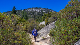
Almost immediately after getting on the trail, we came to our first bridge. I'd crossed this middle-of-nowhere-bridge many times before - on the way to Lost Knife Knoll and Tip of the Spear Point - but I'd never taken the trail the entire way to our destination today - a bridge even-more-middle-of-nowhere than this one!


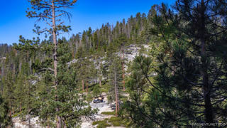
The initial stages of the hike were - as you can expect - familiar. The Tacoma in camp was perhaps in a different place than we usually left it, but even from this vantage point, you can tell we were far from suffering.
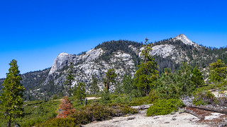
As we hiked, the views of ████████████ and Sleeping Bear Rock poked up through the trees. We'd get plenty of time looking at these fabulous outcroppings through the day, and we'd never tire of them.

As we descended toward the ███████████ - losing some 3000' of elevation over the six mile trek - there was plenty more to see than just the granite mountains of this wonderous place. We enjoyed every minute, taking our time - we literally had all day!


The trail was in reasonably good shape most of the way. Here and there it would peter out a bit, or re-route around a recently fallen tree - but by and large it maintained a consistent downward trend the entire time. For me, this was a plus - uphill hiking is much easier on my knees - and so I was glad to get the down out of the way before I was too tired!


It took us a little under three hours to make our way to our terminus for the day. By the time we arrived we were ready for lunch, but being almost noon and having hiked over the hot granite boulders to get here, we were even more ready for a cool dip in the river!


The bridge - a combination steel truss and suspension bridge - was built in 1957, with the steel transported by helicopter and the cables packed in by mule train to the edge of the canyon before being slid down to the actual bridge site. And it seems to have held up just fine for the last 63 years.


After a bit of water play and nicely cooled off, we found a pleasant spot in the shade next to the river and proceeded to down all the food we'd brought along for lunch. PB&J sandwiches, potato chips, and a softball-sized apple all hit the spot. Water was consumed sparingly at this point - a six mile, uphill battle, in 90ºF enough to keep us aware of the fact that we needed to conserve this scarce resource.
And then, it was back in the water!


With our shirts wet to keep us as cool as possible for at least a few minutes, we took one final look from the bridge deck before heading back up. It's too bad (but really not) that this place is so hard to get to - I could spend a lot of time enjoying a book here.


The hike back was a slog. As with our trip down, we took it slow and steady, stopping whenever we needed to rest in the shade. Still, by the time we were about half way back, @mrs.turbodb was out of water, and we were sharing the last half liter or so I'd brought in my bottles - carefully doled out one sip at a time as I monitored our progress towards the trailhead and water supply back at camp.
By the 12th mile our legs were tired, and our throats were dry. We drained the last of my water as we passed the trail fork to Lost Knife Knoll. But we'd had an amazing time that we won't soon forget. And, waiting for us back at camp was a refreshing dip in █████████████, all the water we could drink, and - last but not least - our favorite camp site, its previous occupants having left at some point during the day.
Yes, life was good!

Over the Following Days...
Mostly, we relaxed. There were no more big hikes, but there was plenty of reading books and processing photos from the previous two weeks of adventure. We bathed in the creek and ate meals overlooking the valley. We didn't see another soul.
Well, except for this guy, flying overhead... a C-130?

Then, for our final night, I decided it'd be nice to take @mrs.turbodb to one more special place - the top of ███████████████. Overlooking Lost Knife Knoll and the ███████████ watershed, it had a view like no other in the area. With a little luck and calm winds, it'd be the perfect end to what had been a wonderful trip.
Eventually we found ourselves here, essentially at the top of the world.


But, to get there, we climbed up through a plethora of wonderfulness, some of the trails narrow enough to have @mrs.turbodb on the edge of her seat...


Dinner on this final night was the simplest of the trip - some of the best tasting hot dogs I've ever eaten, influenced only slightly by the expansive views.
In the morning, we'd pack everything up for the last time and head home. It'd been an awesome two weeks, and while we were both ready for a bit of extra sleep, I can assure you that we can't wait to get out there again!
