
Having pulled into the Centennial Historical Museum for a photo of the train depot, @mrs.turbodb and I each spotted displays that we wanted to check out, so we popped out of the Tacoma for a few minutes to do just that. I headed over to an old Union Pacific caboose, and she wandered into the museum to see what sorts of historical information was available.
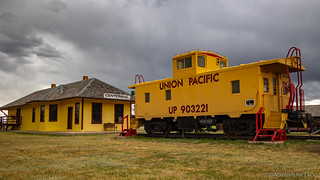
One of the nicest cabooses I've come across.

I've never seen the original system for running water inside before; I got a good chuckle out of the drain.
Knowing what we had in store for the rest of the day, even with our poking around, we only spent about ten minutes in town before climbing back into our trusty steed and heading back out onto dirt as we climbed to more than 10,000 feet in the Snowy Range. We had a good number of items flagged here for our attention - including a hike to the highest point at Medicine Bow Peak - but our first stop was at a little Episcopal open-air chapel, St. Alban's.

A pretty little place where we probably wouldn't have stopped, except for the fact that it was marked on track that's distributed by the BDR organization.
From the chapel, we continued in a westerly direction towards a trailhead that I'd marked as the starting point for our hike. This, it turns out, pleased @mrs.turbodb quite a bit, as she'd spent a week in this area with her dad the previous summer, and wanted me to see how beautiful it was. In fact, when I asked her to take a look at the route prior to our departure to see if there were any things she wanted to add, she suggested the hike to Medicine Bow Peak, and was delighted to hear that I'd already included it on the map!

With snow and wildflowers all around, it was a beautiful afternoon in the Snowy Mountains.
The only problem - as we neared our destination - was that our high elevation meant there were still deep snow drifts, and soon I was out of the Tacoma, checking for the feasibility of passage.
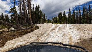
After a few failed attempts at this drift, I finally got out to walk it - and the next drift along the road - to figure out a plan of action.
In the end, the snow was simply too soft and deep to pass, and we backtracked a few miles until we could re-route to the trailhead. It was another indication that we were the first to make this journey for the year, as the passibility of the route was only now becoming a reality.
It was 2:34pm when we set off from the trailhead at Lewis Lake (note: there is a $5 day use fee to park here, or you can use - and I recommend - an America the Beautiful Pass) along the trail that would take us to the top of Medicine Bow Peak. At the time - given the amount of snow we could see around us, and our recent experience on the trail - I think we'd each have given ourselves about a 30% chance of making it to the top. Maybe.

Lots of snow between us and the summit.
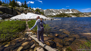
With high water levels, we had to find innovative ways to keep my sneakers dry. It was - within a few minutes - obviously a losing battle.

Yellow-Bellied Marmot is keeping an eye on you!

Soon we left the edge of Lewis Lake as the trail began to gain elevation.
There are several ways to reach the 12,018 foot summit of Medicine Bow Peak. It turns out that I'd mapped the shortest - a little over three miles roundtrip - and a little more than a mile into our journey we came to a sign where our trail joined a section of the seven-mile loop that seems like the more popular route.

No one - regardless of the chosen route - can escape the 1,700-foot climb!
Hiking straight up the face of the mountain - where most people took a more gradual ascent at the other end of the loop - the views of the aptly named Snowy Range were some of the best we've seen. Several times on our way up, we found ourselves stopping just to admire the range.
And yes, that's our story and we're sticking to it. We most definitely weren't stopping because we needed to catch our breath. 

The Snowy Range from 11,047'.

The Snowy Range from 11,340'.

The Snowy Range from 11,561'.

American pika (Ochotona princeps) is keeping an eye on you, too!
As with the roads we'd travelled so far, the hillsides here were covered with wildflowers, and we stopped just as often - again, not because we were out of breath - to view them as we did the mountainous region through which we hiked.

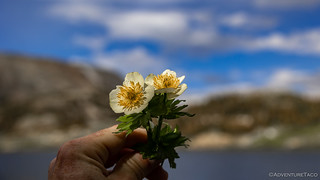
I think these little lavender flowers were my favorite.

A living bouquet.
To our surprise and delight, the trail seemed to pick its way through the snow fields as it climbed higher and higher. Our 30% chance of success climbing to 50% by the time we ran into what I initially referred to as "our turnaround point."

The trail clearly continued, but even we weren't dumb enough to attempt this snow field.
After a closer inspection, it became clear that while someone had navigated this snow field, they'd done it quite some time ago - the snow now too icy and the grade too steep to allow for a crossing here. Instead, we could see where more recent hikers had turned the already-steep-trail into a straight-up-scramble-towards-the-ridge-trail, and after following suit, we soon found ourselves near the top.
The Snowy Range from 11,956'.
Somewhat surprisingly, there was relatively little snow at the summit of the Snowy Range, which actually gets its name from the sugary-white Precambrian quartzites that reflect sunlight and look like snow in late summer, even when there is none. (Roadside Geology of Wyoming) Not that we were complaining.
The survey marker at the top of Medicine Bow Peak is illegible from all the hiking poles that have pulverized it.

The Snowy Range from 12,018', at the top of Medicine Bow Peak. Oh, and some definitely-not-tired hikers.

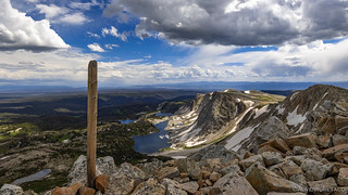
The view north to green valleys and alpine lakes of the Medicine Bow-Routt National Forest.

The view east towards Gap Point, Brown's Peak, and Lewis Lake, Libby Lake, and the Gap Lakes.
Unfortunately, just as we were enjoying ourselves at the top, so were the mosquitoes! So, after a few pictures and a little looking around, we began to retrace our steps back down the mountain. Down was certainly faster than up, though we weren't able to entirely escape the desire to stop for some of the same - or at least similar - photos to those we'd taken earlier.

Some areas were blanketed in yellow.

The Snowy Range from 11,148'. Note: as much as I'd like to, I can't promise this will be the last photo of this range.

Mr. Marmot is still keeping an eye on you.
I really liked the pale yellow petals and bright stamens of these flowers that I found near the beginning of the trail.

Back at the bottom, where you can really see the white quartzites that give this place its name.
It was a little after 5:15pm when we reached the bottom of the trail at Lewis Lake, each of us a little hungrier than when we'd set out a mere three hours earlier. I mentioned to @mrs.turbodb that we should find a reasonably breezy place to eat dinner - so we wouldn't be bugged by mosquitoes - a suggestion that was met with enthusiasm. Of course, we also needed to find camp for the night - and I'd hoped that we'd be camping somewhere in this general area, so we could see the Snowy Range - when the morning light was shining on them - but given the time, it seemed like we might still be a little too early in the evening to call it a day.
Back on the trail for less than five minutes, our next stop - a parking lot at the Libby Flats Observation Tower - turned out to be the perfect spot to eat dinner as we enjoyed 360° views with a warm wind to keep the bugs down.

I don't know why this observation tower was made, but I can only imagine that it was built by the CCC.

The view out over Libby Flats was spectacularly spring. And no, it is not a golf course. The “sand traps” are receding snow drifts.
Dinner - taco-rittos full of guacamole of course - was delicious, and I think it'd be safe to say that the few others who showed up while we were eating in our rocking camp chairs were just a wee bit jealous. Of course, they were likely headed for showers after a day of exploring, and we still had a week left on the trail, so the jealousy was a two-way street.
After dinner - with a good two hours before sunset - we decided that a final short hike to the ruins of a miner's cabin and headframe - was easily achievable before we started looking for camp. A popular and well-marked trail only a few hundred feet up the road, we finished the .75-mile loop quickly.

The old miners cabin. @mrs.turbodb related to me that it was not collapsed when she'd visited 10 months earlier.

The Red Mask Mine consisted of a vertical mine tower (headframe), shaft house and boiler. Claimed under the General Mining Law of 1872, the mine was thought to contain rich gold, silver and copper. Only small amounts of silver and trace amounts of gold and copper were ever extracted. The remains that you presently see consist of the collapsed hoisting tower, rusted boiler and shaft house remnants.USFS Information Sign
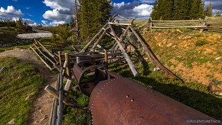
The Red Mask Mine today.
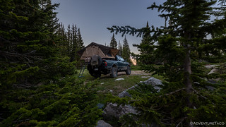
Our hike complete, it was time to find a place to camp. After a bit of searching, we found a spot that we thought wouldn't be perfect, but would keep us in the area so that I could see the mountains in the morning, and proceeded to set up the tent.
As we did, I noticed that there were quite a few moths around, and I figured we'd have a few of them nestled around the tent the following morning. In reality, as we nodded off to sleep, I had no idea.
The Following Morning...
I wanted to be sure that I was awake for sunrise the next morning, so I set the alarm for 5:15am, and though it still sort-of felt like 4:15am for me, I pulled myself out of bed as soon as it went off.
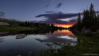
I'd expected some beautiful sights of the Snowy Mountains, but the nearby lake is what really blew me away.
Nestled away in our private little spot.
@mrs.turbodb was up not-too-much-later, and as I began to fold up the tent, I realized that we had a serious problem on our hands. Over the course of the night, we'd ended up with a couple moths in the tent, but as I folded up various elements, dozens - and then hundreds - of the fuzzy flutterers were nestled into every nook and cranny they could find.

These three had squeezed into the fold of the zipper.
Moths, it turns out. look for places to nestle. The seams of the tent - where the window awnings joined the main body, and the main folding seam between the two halves of the floor - are their favorite places, and in the end we had at least a couple hundred of those little buggers that we had to evacuate. The floor seam was the worst, as the only way to clear it was to fold the tent, and when I did, half of the moths flew into the tent. That meant opening it again, and shooing them all out as they frantically fluttered around on the inside. Not fun.
In the end, I think I got all but about five out of the tent, though we'd be finding them in the bed of the truck - nestled here and there and flying out when things moved - for the remainder of the trip!
We didn't have far to go until our first stop - to admire the mountains - but within a minute of pulling out of our short spur and back onto the BDR, @mrs.turbodb spotted five moose grazing along the side of the highway!

Nom, nom.

Clouds along the eastern horizon meant that there was no direct sun on the Snowy Mountains, but they still rose gorgeously to our west.

I guess that's why it's called Mirror Lake.
Only 15 miles into the 75-mile-long stage, we had quite a bit of ground to cover - including another "Alternate" route that eliminated 10 miles of pavement in exchange for a fun water crossing and winding, narrow forest roads. #win and #win.
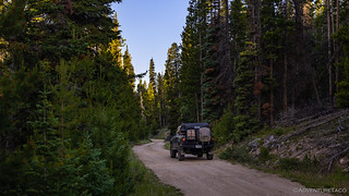
Into the trees.

This section is considered expert due to a relatively wide water crossing. In a Tacoma, it's no big thing.

Good thing I brought the chainsaw!
After a few miles, we rejoined the main route for a few miles - as it headed north towards Elk Mountain - before forking off again for a 13-mile side trip to Kennaday Peak and the fire lookout perched at the summit.
Unlike some of the other BDRs we've run, there were relatively few lookouts along the Wyoming route, so we were excited to get ourselves to the few we knew about, eager to see if they were occupied, and to share stories with their occupants if they were!

As we climbed through the trees, we finally got a glimpse of our destination.

All closed up.

One of the plywood shutters had either been blown off or removed, and it was a bit of a mess inside the lookout. We patched it up as well as we could before heading back down the mountain.

In the distance, the snow-capped Sierra Madre.

Looking north, Elk Mountain.

And away we go.
Once off the Kennaday Peak spur, we were treated to the BDR staple road: a relatively wide, well-graded gravel road. As the miles ticked away quickly, @mrs.turbodb read me an interesting tidbit about Elk Mountain.
Fighting over the Checkerboard
By the 1980s, the Union Pacific Railroad had sold many of the alternating sections of land granted to it by the federal government at the time of construction. In eastern Wyoming, private landowners held most of the former public lands. From Elk Mountain west, however, there was still unclaimed public land, and the so-called checkerboard remained. This situation created tremendous problems for both federal and private land managers. Ranchers who owned or controlled the private land sections also controlled access to the federal sections, which no one wanted during the homesteading era because of the lack of water.
The checkerboard of Wyoming and the Elk Mountain area (lower right).
A major dispute occurred over Elk Mountain when rancher Norm Palm refused public access across one of his private land sections. He granted a crossing right to the U.S. Bureau of Land Management (BLM) and the University of Wyoming - which has a weather monitoring station on top of the mountain - but refused to let individuals do the same.
The big issue was access, but it was tied to economics. Palm and a group of other area landowners banded together and charged a $250 fee for hunting privileges on their land. The Wyoming Wildlife Federation (WWF) argued that the ranchers' policy of charging a fee restricted public use of public land.
The WWF filed suit against Palm to force him to allow people to cross his land so they could reach three sections - 1,920 acres - on top of the mountain.Roadside History of Wyoming
It is - apparently - a well-known story in Wyoming; a story we'd hear from long-time residents that we ran into a bit later on our journey. Total BS that a private landowner could attempt to restrict access like that, they'd tell us.
The infamous mountain. Not on our route, but we still wondered if we could make it to the top.

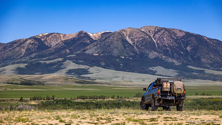
Dropping down out of the foothills and into the fertile farmland to the east of Elk Mountain, this entire valley was irrigated by flooding the fields from the Medicine Bow River.

Hay there.
There's not much to the small town of Elk Mountain. A post office and general store, the police station, a community center, and church are all that line the main street through town. Gas is available at I-80 a few miles north, and that's where we were headed, the second stage of the WYBDR now in the books.

Elk Mountain, Wyoming. Population 191.
It would be a hard stage to beat - given the time we'd spent hiking in the Snowy Mountains - but as we'd soon find out, this entire BDR was full of firsts!
The Whole Story


Love Backcountry Discovery Routes? Check out
BDRs we've run
to find your favorite.


")
")


")
Always enjoy your tales and photos. Some of them remind me of Kennedy Meadows in the High Sierra, slushy! Yes, I do not like the insects. Back when we annually backpacked around Mt. Whitney we'd go late spring or early fall, only drawback was it was very cold at night and usually still ice and snow on the trails so had to be very careful.
We just camped and hiked in the Snowys this weekend. Great place.
That’s cool to hear that you Campton hiked up there in the Snowies! What hike did you do? And where did you camp?
We hiked from the Lewis Lake trailhead to the Lower Gap Lake. We stopped way short of your hike, but enjoyed it none the less. We found some dispersed camping just off highway 130. I sent a few pictures via email.
The access issue is ongoing. There was a recent verdict in a trespassing case where some hunters were arrested for crossing at corners, public to public, but passed through the airspace of the private. The hunters were acquitted.
Here is a good recent article about the issue.
https://www.onxmaps.com/onx-access-initiatives/corner-crossing-report
Yeah, I suppose as time goes on there will be more and more of these types of issues, unless the matter gets settled somehow in a way that both parties are happy with.
My wife found a similar story, as we were discussing this on our return home, but in that case I don’t think the Hunter’s were acquitted. I’m out on the trail right now, but will need to read the story you linked fully when I get back to see what the difference was. Thanks for sharing it!