

Stage 5 of the New Mexico Backcountry Discovery Route - Fence Lake to Grants.
Within 5 minutes of arriving at Fence Lake, we were once again on our way. The highlight of our morning - and perhaps of the entire BDR - was just a couple hours ahead of us; lollygagging around here wasn't going to get us there any faster.
We nearly passed by the Wild Spirit Wolf Sanctuary, my sights so set on what I'd been looking forward to for days. It was only @mrs.turbodb's quick turn in her seat to read the - inexplicably one sided - sign as I sped along that got us to stop for a quick moment to see the wolves.

Don't approach from the south, the other side is blank.
We'd heard about this place the previous day at one of the lookouts we'd visited. Turns out that starting in the late 1990s, Arizona and New Mexico began a program to release wild Mexican Wolves back into the forests and wildernesses through which they once roamed. This effort was - as you might suspect - controversial, with the general public supporting, and ranchers opposing the reintroduction. The Wild Spirit Wolf Sanctuary doesn't have anything to do with those wolves in particular, but is often brought up in the same breath - because, wolves. Rather, the sanctuary is for rescued wolf and wolf-dog pets that can no longer be cared for by their owners.

Wolf Dog.
Seemed like a pretty sad place to us - a bunch of animals caged up waiting for their next meal - and so we made a quick exit rather than sticking around - our route now taking us through the Ramah Navajo Indian Reservation.

Fabulous bluffs.
And then - as was becoming a more regular occurrence than we'd been prepared for, we popped out onto pavement at NM-53, just a few miles east of El Morro National Monument. I turned to @mrs.turbodb, a huge grin on my face, and then I stopped the truck in the middle of the road for a photo.
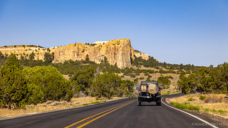
I was pulled over by a Sherriff about 15 seconds after taking this photo. Luckily, he just wanted to check that we were OK, since some dufus had stopped in the middle of the road.
Turns out I could have avoided the whole "police lights" thing if I'd just continued on another quarter mile. There, a nicely placed sign - as long the photographer strategically chooses their position - pointed us exactly where we were headed.

El Morro means "The Headlands" or "The Bluff." There aren't many NPS signs that point at their named monument. 
Having arrived about 30 minutes after they opened, we had the parking lot mostly to ourselves, and we ate a quick breakfast before slathering ourselves in sunscreen and heading into the visitor center to show our America the Beautiful Pass and then experience the monument.
Getting closer.


I'm always distracted by reptiles. Plus, I've never seen a lizard that looks like a garter snake before.
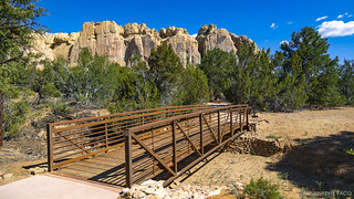
There are two loops at El Morro. The first is the Inscription Trail. Paved, and only half a mile in length, this trail escorted us along the base of El Morro - first to the pool, and then past hundreds of Spanish and Anglo inscriptions, as well as pre–historical petroglyphs.

Back before Toyota Tacomas, the 150 miles from Albuquerque to Zuni typically took 9 or 10 days by foot and horse. Dependable water supplies like this one made for welcome relief for natives and immigrants alike, and many of them left their mark along the base of the wall to the west.

The pool.

Both women and men passed by El Morro, but very few women left their inscriptions. Miss A. F. Baley was one of the exceptions. America Frances Baley and her sister Amelia were part of a wagon party headed from Missouri to California in 1858.

E. Pen Long was a member of a US Army expedition led by Lt. Edward F. Beale to find a wagon route from Fort Smith, Arkansas, to the Colorado River. The group, which first passed by El Morro in 1857, was testing the usefulness of camels in crossing the deserts of the southwest. Beale wrote positively about the camels in his journals, but the Army abandoned the experiment a few years later due to the start of the Civil War.
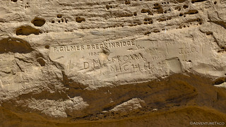
We all know the name Breckinridge - or at least a variant. P Gilmer was a graduate of Virginia Military Institute, passing by El Morro in 1859. After arriving back in Virginia, Breckinridge enlisted to the Confederate Army and fought against the United States. The town of Breckenridge, CO, was named for Breckinridge's family, but Colorado was decidedly pro-Union and the town changed the spelling of its name to distance itself from the Breckinridge family's confederate connection.

On the 25th of the month of June, of this year of 1709, Ramön Garcia Jurado passed through here on the way to Zuni.
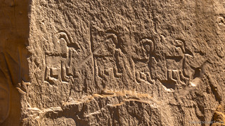
Hard to capture in the light we had, native petroglyphs show the bighorn sheep that likely frequented the watering hole.
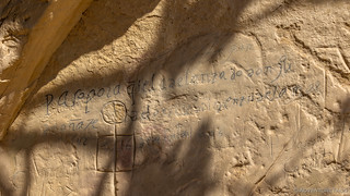
One of the oldest and more famous inscriptions at El Morro - that of the first governor of New Mexico, Don Juan de Oñate - was inscribed in 1605, fifteen years before the Pilgrims landed at Plymouth Rock.

R. H. Orton became adjutant-general of California after the Civil War. In the early years of the Civil War, the California Column, as it was known, was sent to New Mexico to reinforce Federal troops expecting Confederate hostilities. Orton held the rank of captain when the First Cavalry was mustered out from March to October of 1866. He may have made his inscription as he returned to California.

General Don Diego de Vargas, who conquered for our Holy Faith and for the Royal Crown, all of New Mexico, at his own expense, was here, in the year of 1692.

At the apex of the butte, dozens more inscriptions, many of them painstakingly carved in a rectangluar box. Almost like a collection of license plates.
The second hike was the longer Headland Trail. Departing from the end of the Inscription Trail, this is a two-mile loop back to the visitor center and definitely worth the effort if you're planning to visit El Morro.

Inscriptions continue along the edge of the mesa, though much more sparsely as the Headland Trail begins.

Walking around the base of the mesa - the switchbacks to the top depart from the back side.
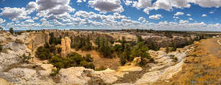
Atop of the bluff, the views were spectacular. The Zuni Mountains, the volcanic craters of the El Malpais area, and the El Morro valley spread out in the distance. But most incredible - at least when we initially reached the top - was the view of the box canyon inside the horseshoe-shaped butte.
El Morro's box canyon.

Pillar of light.
The trail is well marked - much of it carved into the sandstone by the Civilian Conservation Corps decades ago. Following the shape of the butte to the opposite side, we were able to experience the entirety of this place before coming upon the main attraction - the Ancestral Puebloan ruin, Atsinna.

They called this "Alligator Juniper," but I didn't see any teeth, and it certainly didn't live in the water.

The clouds were looking mighty fine the entire time we were there.

Stairway to heaven.
Astinna, which means where the pictures are on the rock, was occupied from roughly 1275 to 1400 by ancestors of today's Zuni people. While only a few rooms - including a kiva - have been excavated, the town consisted of more than 800 rooms, most of which remain protected under several feet of dirt.

Approaching from below, it initially appears to be a reasonably normal - if a little boring - ruin.

Looks can be deceiving.

A round kiva surrounded by a square wall.
Our loop nearly complete, we'd thoroughly enjoyed the two hours we'd spent at El Morro. While not technically part of the NMBDR, I can't recommend this place highly enough - take the time to walk around - even if you don't do everything. The views and history here are second to none.

Even the views on the way back to the visitor center were postcard worthy.
Unsure how we were going to top El Morro - hint: we weren't - we got back on the trail (highway) and headed east. Having just completed a detour, we had another detour decision to make: should we go to the Ice Cave and Bandera Volcano, or the El Malpais National Monument?
I'd assumed that we would - partly because it was a point of interest called out on the BDR map, but also because it sounded pretty cool. Luckily however, @mrs.turbodb had been doing her homework on the El Malpais and informed me that the Ice Cave and Bandera Volcano were actually a paid attraction on private land, and the reviews were only meh.
Better, she suggested, would be going even a little further out of our way - further into the monument - to hike through the lava tubes. Specifically, checking out Junction Cave. So, that's exactly what we did!

The entrance to Junction Cave. Never mind all the crumbling rock, I'm sure it's fine.

Looking up toward the exit.
Not more than 100 yards long, Junction cave is the first in a series of collapsed lava tubes that can be hiked - under- and over-ground - in a loop for anyone who hasn't gotten enough after a single cave. For us, the single cave satisfied our curiosity, and while it didn't really hold a candle to El Morro, we were glad we'd ventured a little farther than the tourist trap that'd almost gotten us.
Plus, we knew that there were dirt roads in our future, and our stomachs were warning us that it was getting on lunch time. They were right of course - it was 12:15pm. And so, we retraced a few miles of pavement, turning onto dirt 15 minutes later, where we promptly took our third detour of the day - this time, towards Oso Ridge Lookout.
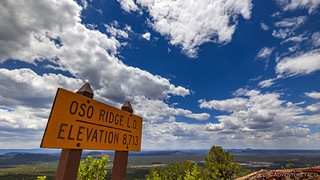
We have arrived.
Unlike the other lookouts we visited, the road to Oso Ridge was short and the lookout itself didn't tower over the landscape. Still, the views were panoramic and we were thrilled to find the tower staffed when we arrived. In fact, I completely forgot to take a photo of the lookout as we were quickly granted permission to come up.

The generator house from Los Angeles-Amarillo Beacon 61. Built in 1929, this shed was the last one in operation on this route, finally shutting down in 1966. The lookout was built within the structure of the beacon tower by the USFS during the 1930s, it has been rebuilt since that time.

As with all the other lookouts we visited, much time was spent curiously discussing the adventure we were on. Luckily @mrs.turbodb had brought along our map on which she'd traced the route, aiding in the explanation.
Hungry, and a little uncomfortable being in close proximity to another human being without wearing a mask, we didn't loiter long on Oso Ridge. With no shade to speak of, our plan to eat under the lookout was foiled, and we headed back down the hill to find something a bit more conducive to sandwich munching and chip devouring.
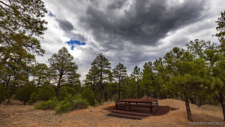
It took us half an hour to find the base of an old cinder cone - one of the many we'd seen from the Oso Ridge Lookout - where the shade from the nearby pine trees made lunch preparation and consuming much more pleasant.

Lunch at the base of a volcano. Check.
And then we were off. Despite the fact that our day had been a series of detours so far, we had only 20 miles or so before we reached the end of the stage in Grants. And, if past stages were any indicator, a good half of those miles might be paved. 
For now though, we sort of enjoyed the forest. Sort of, because it was really starting to feel like we weren't seeing New Mexico - or at least, what we expected of New Mexico. Oh, and it was starting to look like rain - not an issue in itself, and nice from a temperature perspective - but we were a bit wary of what the roads would be like if they were saturated and slick.
We happened upon a mine in the Zuni Mountains.

The quartz on the ground and in the tailings around us suggested that there might be gold in them there hills!

A Coopers Hawk kept a close eye on us as we drove by.
Then, we found a short, steep, mogully section of road. Keen to do a little flexing - we hadn't needed 4WD on this trip yet (not that we needed it now) - I looked over at @mrs.turbodb and smiled as I grabbed the camera with a, "Be right back."
She - of course - knew exactly what I was up to. This wasn't the first time I'd pulled a stunt like this, leaving the truck suspended on a hill by the emergency brake, so she asked, "So what do I do [when the brakes give way]?"
"You'll hit a tree. You'll be fine." Probably not the best answer, looking back on it now.

Flexy.

But still with room for more travel in the rear!
Of course, the e-brake held and no one hit any trees, and a few minutes later we may has well have been on pavement as our secondary road popped out onto Zuni Canyon Road and our speeds increased to 50mph on the well-graded, gravel surface.

Some nice contrast, even with the sun behind a cloud.
As we rolled into Grants, we had several things to take care of. Fuel of course, but @mrs.turbodb also wanted to call her mom, and we needed to stop at an auto-parts store. But all those things were put on hold as we rolled into town.
Because there's no way I was just driving by a tank without taking a picture.
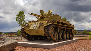
The M42 "Duster" was a self-propelled anti-aircraft weapons system consisting of two 40mm Swedish Bofors anti-aircraft guns mounted onto a light tank chassis. Produced by General Motors between 1952 and 1959, the Duster officially entered Army service in 1953, the year the Korean war ended. US service members nicknamed the system "Duster" because of the clouds of dust it generated when moving over dirt. The regular Army used Dusters until the early 1960s, when it began turning them over to the Army National Guard. As the Vietnam War escalated, the Army began recalling Dusters to active service. Since there was not much of an enemy air threat in Vietnam, the Duster was relegated to ground support roles, namely point security, convoy escort, and perimeter defense. It was found to be particularly effective in perimeter defense against massed infantry attacks, so much so that the Viet Cong called them "Fire Dragons."City of Grants Info Board
Anyway - back to the auto parts store. The problem had been discovered the previous evening as I'd performed my "nightly" ritual of quickly glancing under the truck to make sure everything seemed operational - there was fluid dripping from the steering rack. It wasn't a lot - in fact the reservoir on the power steering pump still read full - but I wanted to pick up a bit of ATF just in case.

Probably unnecessary, but good peace of mind.
And with that, we ticked off our fifth leg of the BDR. The leg itself hadn't been much to write home about, but boy had we had a great time on our detours! Little did I realize that the following leg would give it a run for the money, and we would finally feel like we had entered New Mexico!
The Whole Story


Love Backcountry Discovery Routes? Check out the
BDR Index
for all the routes I've run - they are fabulous!


")
")
")


")
I just went through that area last month but somehow you make it look a lot better than I remembered it.
LOL, well, if you were on the NMBDR, the truth is that I agree with you 100%. You'll notice that the parts of the stage that I (we) really enjoyed were El Morro, El Malpais, and Oso Ridge Lookout. Guess what - those were all side trips off of the actual BDR! So yeah, this section of the route itself was a bit... meh. Hope you're enjoying the story, and I'd love to hear your take on any sections where you have one - always great to get more perspectives!
I was on the CDT all the way to Montana where we decided to call it quits because of the smoke and heat.
Oh man, I really want to do the CDT. I have a couple routes to base a trip off of, but have no idea how I'm going to find the time necessary to do the trip in one shot. I'd love to pick your brain on how long you allocated, what you felt were awesome parts, side trips worth doing, etc.
We started the CDT on June 21 at Antelope Wells and I quit on July 26th near Helena Montana. The Colorado backroads from Frisco on were super smooth. Most of our hard roads were in NM after La Mosca. We got nailed by a hailstorm coming down from La Mosca and had to pull up off the trail and spend the night due to mud. It was a real mess.
Union Pass in Wyoming is a beautiful long undulating epic. Boreal Pass in Colorado is a rocky mess. Because I was driving my high top Sprinter I did not do Stony, Elwood, Engineer and Cinnamon passes. The Jeep’s, Landy and e350 plus a Ranger and Mexican VW truck with Alu Cab did all of them. Pitkin and Tin Cup were packed with motos and fffing Quads. Brooks Lake in Wyoming especially Pinnacle CG is nice. The area around Henry’s lake and Island Park is really crowded. The Red Rock road however is pretty cool..I’d say the Colorado backroads are the most fun and scenic. I still have the 3 sections from Helena to the Canadian border to do. The remaining 4 rigs are still on the trail and expect to go into Canada on Aug 9..
Jeff Smith has posted some stuff about the trip on Expedition Portal.
TTT The Continental Divide.
Wow, that's a long trip; must be a lot of fun to be out that long (and require some shower stops! ?) I'll check out the report on ExPo - sounds like a fun read. Thanks for the pointer, and I may reach out again as I get closer to making the trek myself. 👍
Having been a volunteer at a wolf habitat, the one thing we emphasized to the visitors was to never try and become the owner of a wolf dog, or a full blooded wolf for that matter. Reasons why would take pages to explain. So, yes, it is sad to come upon a rescue habitat such as the one you mentioned, but they are trying to ease the suffering and loneliness those canines have been previously subjected to.
Those inscriptions are fascinating and I still can't figure out how some of them look as though they were lifted from paper onto the walls.
Yeah, I'm with you that the wolves/wolf dogs are surely the ones that got the short end of the stick in all of this. The sadness was in seeing that - even in the habitat - they aren't living a great life, it's simply better than what they had before. Of course, I'm sure most/all of the people working there love them, but still, it is hard to give them what they really need, which is not cages and pacing (in an ideal world).
The inscriptions that have dark lines in them have an interesting story. Back when the national monument was initially created (or before it even, I forget exactly), the NPS used carbon (essentially a pencil) to trace the inside of the inscriptions. Their thinking was that it would make them "more visible" and less likely for people to deface them. Best intentions, but they now realize they made a mistake. Of course, they can't remove the carbon because that would harm the inscriptions even more. Interesting how we all live and (hopefully) learn over time, and none of us are perfect.
Because we were not on the nmbdr we missed Candy Kitchen. What is it?
Also, up the road from El Morro we took a dirt road that took us all the way to Grants and had a great camping spot along the way. Not sure what the road number was.
Also, got water from the garden supply at Walmart in Grants.
Candy Kitchen is just the town/road that the Wild Spirit Wolf Sanctuary is in/on. And the road up from El Morro was (likely) a combination of 50 and 49; both of which we were on for a time prior to Grants. The staffer at the Oso Ridge Lookout told us that 49 went all the way through.
Goodness gracious...stopping in the middle of the road like us tourist would do? Thought you were a pro? I KID!!!! Ha!! Skimmed reading the adventure for now but in awe of the beauty. Can not wait for my own NM adventure. Thank you for the inspiration. Y'all have fun and be safe!!
Thanks Jeff! Glad you're enjoying! And yes, even I find myself touristing it up more often than I'd care to admit. I mean, there's a reason the tourist attractions become attractions - they are usually pretty darn cool. Have fun on your NM adventure, it is - as are most places - a great one to explore.
I looked at my Gaia track and it was 50. Nice boondocking spot about 5 miles in.