
It's been more than a year since I visited my first Grand Canyon Polychrome site out on the Esplanade and I've been very curious to get back and look for more of these wonderful pictographs. Naturally, being rock art - and a relatively rare variety at that - the locations of the sites are a closely guarded secret by those lucky enough to know them. I'd hoped to finally meet and head out on a hike with Randy of adventr.co - one of the foremost rock art enthusiasts I know - but family matters came up and he was unable to make it. Still, with a possible lead on another Polychrome panel, early spring seemed like the perfect time for @mrs.turbodb and me to don our backpacking gear for the second time ever, grab a bit of water, and venture out into the vastness of the grandest of canyons.
- - - - -
Prologue
A month before our scheduled departure, I had a look at the weather and started rethinking the plan. With temperatures predicted to reach a high of 47°F during the day - and drop to a nippy 27°F overnight - I worried that it might be a little too chilly to be fun, especially when we were in camp and not generating heat by moving. I knew my new sleeping bag could handle it, but after personally spending a very cold night in @mrs.turbodb's bag, I wasn't sure she'd be as toasty as she might appreciate.
Still, while trying not to get my hopes up, I continued to check the weather. Then, a week before blast-off, things started to look a lot warmer. Across the board, the weather guessers updated their predictions: daytime temperatures around 85°F, and 50°F once the sun dropped below the horizon. Yay!
I know now that my excitement was misplaced. But more on that as we survive. As usual, we arrived at our trailhead under the cover of darkness.
Note: Camping on the North Rim of Grand Canyon National Park and hiking in the area (including the Esplanade) requires a permit, and a National Park pass.
Permits range in price from free (day use hiking) to inexpensive (camping) and help to maintain this amazing place so we can all enjoy it. For more information and to get permits, see Tuweep Permits. I've found that it's often a good idea to call, since it's not always clear which zone you need a permit for.
There's no better way to get a National Park pass than to pick up an annual America the Beautiful Pass.
The following morning...
Knowing that we had 10 miles to hike, we were up at sunrise the next morning.

We'd checked two duffel bags full of our backpacking gear for the flight down, so the first order of business was pulling everything out and repacking it all into our packs. This is probably second nature - and boring - for those who backpack regularly, but this was only our second time using this stuff, so it was still a fun novelty. As I stuffed in my last bit of gear, I remember thinking to myself, "This sure seems a lot lighter than when we hiked Grand Gulch."
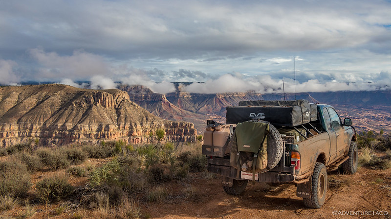
Ten minutes later - after we'd eaten breakfast - we filled our water bottles and suddenly my pack seemed a whole lot heavier. This was expected, but still unwelcome. After a remarkably dry winter, we knew we couldn't count on finding water, so we hoped that the 10L we had between us would be enough to carry us through two days on the trail. Locking up the Tacoma, it was at little after 8:15am when we followed our trail over the rim and began our descent to the Esplanade.


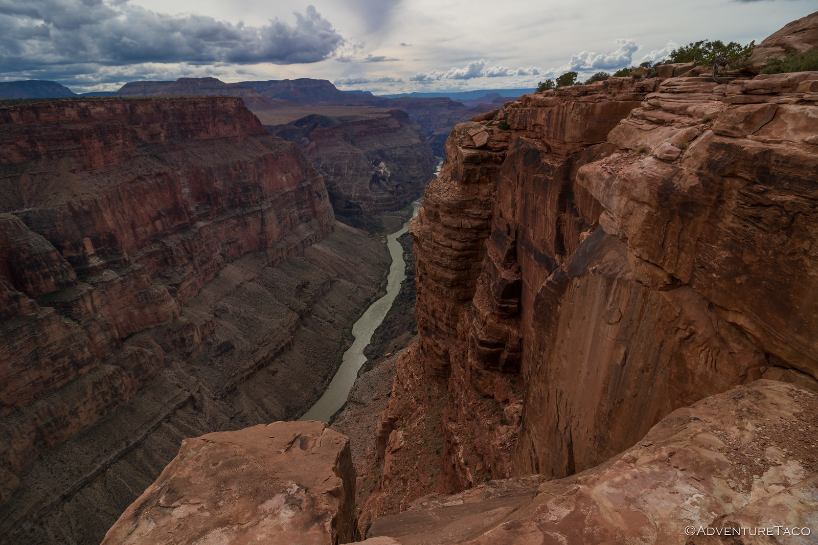
The Esplanade is a wide plateau composed primarily of Supai sandstone and located about 2,000 feet below the North Rim and 2,000 feet above the Colorado River. After dropping down to the first flatish area - about 300 feet off the rim - @mrs.turbodb mentioned we were about halfway down.
Having hiked this trail previously, I knew that wasn't the case. Mentioning that we still had quite a bit of down to go, she reminded me that I'd described the hike as "mostly flat" and "600 feet of elevation, plus the undulating of the Esplanade."
In fact, I had. 
You see, in mapping our route, I'd created two tracks - one that followed the Tuckup Trail around the Esplanade itself, and another that accessed the Tuckup, from our camp spot. I'd completely neglected to include the two miles and 1,400 vertical feet of access trail in my estimate! And with that, our 10-mile hike became 12, and our mostly flat backpack, not flat at all.
Trying to sweep the mistake under the rug, I did my best to refocus our attention on the spectacular place we had entirely to ourselves.


Even with our packs as heavy as they would be the entire trip, fresh legs - and temperatures still in the low 70s °F - meant that we made it down to the Esplanade in just more than an hour, and with relative ease. Going back up was going to be a slog, but that was a problem for "tomorrow us," as we enjoyed the greenery that is so fleeting in these parts of the world.

Sitting at an average elevation of 4,200 feet, water sources on the Esplanade were not historically abundant, but after heavy rains, water could easily be found in natural sandstone pockets. These potholes - along with plentiful bighorn sheep and natural sandstone shelters - must have attracted early inhabitants, and evidence of their lives here still exists today.
In fact, in addition to the Hades Panel - the ultimate goal of our excursion - I had several other points marked on my map that I hoped might be shelters or rock art sites. In the end - as temperatures climbed and the miles stretched into the distance - we bailed on most of them, but we did check out a few and found a couple of nice surprises!
When visiting rock art and ruin sites, be respectful.
This is most easily done by following the Leave No Trace principles; leaving the place exactly as you found it and taking with you only photographs and memories. In case that is not clear enough for some reason, here are examples of respectful behaviors:


As one of our first stops, we probably spent a little too long at this ancient shelter, because it definitely seemed hotter as we hefted our packs and continued out onto the Esplanade. It wasn't yet 10:00am, and even though I hadn't yet taken a sip, I started to wonder if we were going to have enough water.


Pretty quickly we realized that wandering off trail to the various GPS waypoints I'd marked wasn't a winning strategy. At least, not for us on this particular trip. Even with the binoculars that @mrs.turbodb had lugged along, we were spending too much time - with heavy packs strapped to our backs - scanning the endless sandstone walls and alcoves for any hint of habitation. Plus, with the canyon walls growing taller around us, we were working our way into a situation that was going to require a lot of backtracking to regain the trail.
And so, even before we'd stopped for lunch on the first day, I mentally reprioritized and reset my expectations. There was one goal, and only one goal: hike twelve - not ten - miles across the Esplanade under the scorching sun, and hope to find a single Polychrome Panel amongst millions of acres of orange rock. What could possibly go wrong?


Making matters slightly more difficult, we weren't even sure if we were on the trail. This was partly understandable - we'd purposefully diverged from its meandering path as we'd investigated a few of the coordinates I'd brought along - but we also found the first six miles of trail along the Esplanade to be rather sporadic. This added work to every step - a veritable minefield of cactus underfoot - as we searched for faint trail segments and fading footprints of hikers before us.
Our pace slowed from a little more than two miles per hour to less than half that, and as the temperature continued to climb, I reminded @mrs.turbodb to conserve as much water as possible. We still had a long way to go. Not to mention coming back!


It was a little after 12:30pm when we started looking for a spot to eat lunch. With the sun halfway across the sky, there wasn't much in the way of shade, but after hiking for another 45 minutes, a small overhang along the edge of a drainage provided just enough cover for us to ditch our packs and set about the assembly and consumption of PB&J sandwiches, an apple, and - in my case - a few potato chips.
I also took my first swig of "dang, this is so warm it's gross," water. It was bliss.

I didn't end up mentioning anything at the time, but part of me wondered if the smart move at this point was to turn around. I could tell that @mrs.turbodb was really struggling. The temperature now - at 88°F - was squarely in the what-were-we-thinking zone, and with the added weight of our packs, she mentioned feeling queasy as we made frequent stops to lower her heart rate. Still, with a few words of support and a sip of water every now and then, she pushed on through the always-changing-and-yet-still-the-same world around us.


Luckily, as we pushed further and further onto the Esplanade, the trail became more obvious. A copious number of cairns lined several harder-to-follow sections, and well-worn grooves ushered us over the blistering terrain. We both commented on this phenomenon - why would the trail get better further from the trailhead - and theorized that it was likely due to a "funnel effect." Hikers - initially finding their own way - eventually discovered the main trail, and joyously followed it rather than trapsing through the cacti and yucca that covered the official GPS track.


Every hour we hiked, it got hotter. This is - of course - normal as the sun continues to warm the atmosphere and heat the dark orange sandstone. By 3:00pm, we longed for the 85°F highs that our weather apps had suggested; it was 92°F and rising. Still, we pushed on at a plodding pace - one to one-and-a-half miles per hour depending on the terrain - as we worked our way along the base of the North Rim. At one point, we ditched one of @mrs.turbodb's 2-liters along the side of the trail in order to reduce the weight she was carrying, and to ensure that it was available for our return trip the next day.


An hour later, we rounded the most prominent point we'd pass along the canyon wall. Here, side canyon would force us to dramatically change direction in order to stay on the Esplanade, its cliffs dropping another thousand feet as the landscape funneled water toward the mighty Colorado. This change in direction brought both good news and bad. On the one hand, it meant we had only two miles to go. On the other, at our current pace, it'd be nearly sunset by the time we arrived and began our search for the Hades Panel.

We ticked off another mile. Now 11 miles into the hike, we were both getting tired. For the first time, my mouth started to feel dry - not a great sign, but also not unexpected given that I'd been trying to conserve water. I hadn't had much to drink except for the 16oz I drank with lunch.
Spotting a large, reasonably flat outcropping of sandstone about a half mile ahead, I pointed it out to my hiking companion and declared it as our camp area. It wasn't quite as far as we needed to go to search for the pictographs, but it would provide us a place to both ditch our packs and ensure that we weren't trying to find a cacti-free patch of sand to sleep on for the night.
I also thought - but didn't mention - that it might be a good spot for @mrs.turbodb to wait while I pushed on alone in the rock art search. I'd find out soon enough that she was thinking the same thing!

There is no doubt in my mind that the place we found to camp is one that's been used for that purpose over thousands of years. The slickrock surface was both reasonably flat and devoid of excessive sand, making it the perfect spot to lay out our things. A small alcove nestled into a 10-foot sandstone ledge on one side surely provided shelter for those who'd used this place in less-ideal weather conditions.
And so, we dropped our packs and decided that this would be the spot we'd call home for the night. Almost immediately, @mrs.turbodb had her socks, shoes, and various other bits of clothing off in order to cool down. I started removing most of my gear and water from my pack to shed weight as I searched for the pictograph panel that'd brought us all this way in the first place. Soon, I was bidding her farewell as my eyes searched the terrain for the easiest path to the little red dot on my GPS.
A little red dot that might be nothing, but that I hoped would make the whole trip worth it.

With an empty pack - just my camera, extra lens, and tripod - I covered the ground between our camp and my little red dot with relative ease. There's clearly a reason I favor long day hikes over backpacking! 
Studying my topo map, I evaluated the various approaches that I hoped would lead me to rock art and decided on one that was a little longer but seemed the most promising from a feasibility perspective. After all, I knew I was only going to get one shot at this before it got dark.
My utter sense of relief - as I spotted the first glyph in the alcove above the wash - was hard to describe. Climbing up as efficiently as I could, it was quickly replaced with a feeling I find much more familiar: I was a kid-in-a-candystore!


Almost from the get-go, I had to use the tripod. The sun was long gone from the narrows, and with the alcove shading even more of the light, I pushed my camera and lens to their limit, and - pumping up the ISO and fully opening the aperture - maybe even a bit beyond. Still, the real magic was in being here, and while I knew @mrs.turbodb was thoroughly enjoying herself back in camp, I wished that she was with me to experience it all.
With the sun below the horizon, I knew I needed to start making my way back to camp. Unlike much of our afternoon's trek, there hadn't been much of a trail between camp and the panel, and while I had a headlamp, picking my way through rocky terrain that was crawling with cacti wasn't going to be a bucket of fun.

It was pitch black when I arrived in camp 30 minutes later. There - having had a chance to relax a bit - @mrs.turbodb was in much better spirits, reading her Kindle and keeping an eye out for my return. A pre-prepped dinner - chicken pesto pasta - was already waiting on the sandstone, and we both tucked into the tupperware with gusto.
But while eating was necessary - and delicious - it most definitely was not the highlight of our evening. That came a few minutes later as we deployed our new Big Agnes Copper Spur UL 3, unfurled our pads and sleeping bags, and got horizontal.
Knowing we had to do it all again the next morning, we were asleep within seconds.
The Whole Story


Thanks for the great report and all the pictures...you have me really thinking hard about doing this trip in the fall. I'll be 68 then but still get around pretty well, did the Harvest Panel in Canyonlands from the River a few months ago. The slow pace and difficulties of the trail hinted at in your FB post had me concerned a bit that there might be a lot of elevation gain/loss or technical climbing, but here I see it's just lack of trail and a lot of cactus to avoid. I have a FB acquaintance who has been to most of these sites, sometimes he shares locations, sometimes he doesn't. Fortunately he said he'd give me this one if I decide to go. He echoed your description of the routes difficulties, and between what he shared and your report I think I have a pretty good idea where the panel is. Hopefully he delivers waypoints, as it's a long, hard trip to come up empty on! I also enjoyed your Snake Gulch report and also have a funny story there. My wife insists I told her it was about a 7 mile hike...I guess she didn't hear the "each way" part and was fuming on the way out. I was also intrigued to hear about all the rock art you saw across the gulch on the opposite side as the trail. I scanned over there continually feeling there had to be stuff there, but never spotted a thing!
Hey Tony, glad you enjoyed the story and photos! This is not an easy hike, and fall is a tough time to do it due to lack of water. Still, if you go in late fall - after some rains - you might be able to find some potholes, which would be a lot nicer than carrying all of your water for both out and back. If you do go, have a great time, it's a beautiful location, even if you don't find all the rock art (I know that I was close to some more, but didn't find it!).
Snake Gulch is another one where I think it's pretty much impossible to see everything, even with a return trip or two. I didn't know him at the time, but I've since met the site steward for that area, and I know he's out there discovering new things all the time! I will say, my wife is now convinced that I purposefully underestimate the length of all our hikes. If I do, it's only because I want company. 😉
Thanks, yeah the water carry won't be much fun but for 1 night I think I can handle it. Yes I was somewhat surprised by the number of people who make multiple visits to Snake, but I can see why, very easy to miss things as your post reinforced with me. There was one low ground-level recess at the base of the cliff along the trail that piqued my interest. It was only about 2' high and I had to slide on my back to get under it. Seemed like an unlikely place to see anything, bur sure enough, there was a petro on the ceiling. Nothing special about it other than the well-hidden location and the feeling of seeing something that everyone else just walks past.
"Cruising in the Esplanade" is so deceptive! The map makes it look pretty flat. What could go wrong, except frequent up and down, blazing sun without shade, and the weight of water? October-December is the best time out there, I think. I'm glad you found your panel. It would be disappointing to miss it, though the scenery is worth the hike.
100% on all of that. The up/down of the terrain - just enough to not be captured on the topo is definitely deceptive. Though, interestingly, we did notice that our net elevation was approximately between when we "entered" the esplanade and reached our destination! That must mean it was easy, right? 😉
October-December would probably be a great time, since the rains will have already come and so water will be plentiful. Certainly when we explored the North Rim - albeit in trucks, and before I began hiking in earnest - there was plenty of the wet stuff. We even named the trip - F.U. Rain - for the weather!