
I have organized this story a bit differently than most.
Some of the locations have little or no reporting on the internet and I feel they should remain that way or someone I respect has personally requested that I not share them; as such, locations have been redacted and/or not mentioned, I've used non-official names for local landmarks, and the order of the trip has been randomized.
Please, if you know the locations shown here, I encourage you to enjoy them as much as I did - and follow my lead by not mentioning their names or locations in order to keep them a little less well-known, and special.
For more on my approach, you can read Do you have a GPX for that?.
I can't tell you how excited I was to hike up the canyon this morning. A trek I'd been planning for months, its remote location relative to much of the rest of the park was the only reason I hadn't done it sooner. Boasting phenomenally polished narrows, an enormous chockstone, and a short side trip to Death Valley's largest arch, it was sure to be a highlight of my trip.
That is, if the treacherous route didn't end in disaster. 
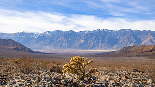
I got a relatively late start - having gotten up at sunrise, I still didn't reach the trailhead until just before 11:00am - distances in the park, deceiving as always. Still, I figured that with sunset still six hours away, I had plenty of time for my trailless hike up the alluvial fan and into the █████████████████.

As I turned around to get my bearings for the hike back, the Tacoma was already growing small at the bottom of the wash.
As I trekked across the desert, I once again immersed myself in the familiar sights and smells of the golden cholla and fragrant creosote. From high above I must have looked like an ant, slowly making my way the nearly two miles to the canyon mouth. Along the way, I stopped several times to admire the views along the way.

After half an hour, I'd certainly covered some ground, but I wasn't exactly there, yet.

A baby cholla glowing gold.
Grandma cholla.

Barrel cactus seem much more common on sheer canyon walls, but there were several reaching toward the sun as I climbed the fan.

Every now and then, the bright green of a Joshua Tree broke up the generally-yellow landscape.
An hour after setting out, I finally reached the mouth of the canyon - the grandeur of what I was about to experience, still buried behind several colorful low hills. The hike had been easy to this point, and I found my anticipation growing as the walls began to rise up around me.

Still looks unassuming, but oh, how looks can be deceiving!

The uplift of this gray-green hillside was so striking as I looked back over my shoulder.
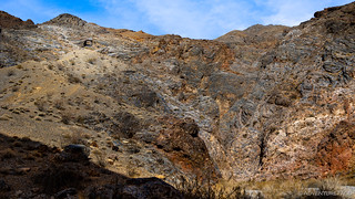
Immediately the geology of this place jumped out at me. This would be a recurring theme over the duration of the trip - and my hikes into the bowels of the █████████████████ - and I found myself stopping time after time to admire the mosaics of color and structure that made every step of the hike a visual splendor.

Petrified mosaic.
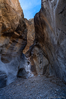
After a medium-length stint up the wide mouth of the lower canyon, the walls began to narrow and I knew the real fun was about to begin. Shortly, I found myself at the first of several dry falls I'd have to navigate, should I want to continue along my way. Certainly - at this point - I wasn't about to turn around, and so careful hand-and-foot placement were the order of the day.

One of my favorite parts of desert hikes are the challenging sections.
It is at this point that I should probably mention some extra preparation I'd done for this trip. Knowing that I'd be in slightly more dangerous situations than "just a hike in the desert," I'd made sure to bring along a few extra pieces of kit. Most importantly, I had my Garmin inReach Mini, along with having instructed those at home how to interpret the messages I planned to send. In addition, I'd also brought along some rubberized gloves and a homemade walking stick - both of which would prove extremely valuable in navigating the sharp - and sometimes loose - terrain.

Ready for a bit of climbing, and rougher-than-normal terrain.
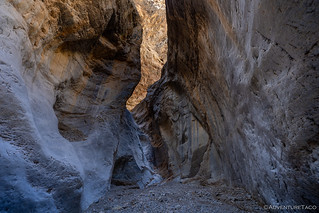
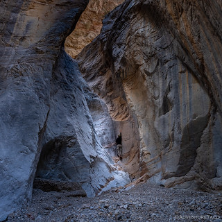
After climbing the first dry fall, the canyon changed dramatically. Gone was the wide, crumbly wash - the walls pushing in closer and closer, the surfaces polished from centuries of floods and the associated gravels that now spilled out into the valley below. Around every turn in the canyon, I craned my neck as I looked skyward.

A horseshoe bend, polished smooth by water that once rushed through.
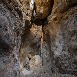
For me, the highlight of the hike was a huge chockstone that I'd seen in a the initial trip report I'd found on this place, and then more recently - only increasing my desire to visit this place - from Ken @DVExile who also happened to have this special place on his list. An audible celebration escaped my lips as I rounded a corner and caught my first glimpse.
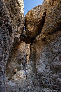
If gravity hasn't won yet, I'm sure there's nothing to worry about ...mostly.
Admiration.
Continuing on, I had a hard time putting my camera down. The steely blues and warm browns continued to decorate the walls around me, a few easy dry falls presenting themselves along the way. I knew my luck could only hold out for so long - eventually a fall too high to negotiate would mark the end of my adventure. Until then, I soaked it all in.

Colorful contrast; mid-afternoon sun lending a warm glow as it worked its way into the depths.

Narrow passage.
It wasn't all that much later that I hit the dry fall that I knew should be my last. While not significantly taller than the first, the surface was much smoother, making the ascent - and more importantly the descent - a much more tricky proposition. For a while, I contemplated my next move.
Doesn't look too bad.

Human form added for a little scale.
Even finding the highest point on which to place a toe, I wasn't going to scale this one easily...
Maybe I can approach this from a different angle.

Success!
Now, I should note several important aspects of this climb, since there will be those who may want to follow in my footsteps.
-
- Please don't do anything that makes you even a little bit nervous; this is not a place where an injury is easily recovered. Additionally, the high canyon walls make satellite communications iffy at best, and so SAR (Search and Rescue) may never get your SOS should you press the button on your communicator.
- Remember - up is significantly easier than down. In making climbs like this, I have found that climbing up and then down, then up a bit further, and down again, and repeating the process helps to ensure that I never reach a point where I can't get down. It takes longer, but many times, slower is faster, and it's certainly safer.
- Lastly, this climb was tricky enough that I wasn't comfortable attempting it with any gear strapped to my body (camera, etc.), so you'll notice that I have no photos of anything above the fall. As an athletic person who has been climbing things all his life, that should give pause to anyone who finds this fall and is contemplating what to do. Please, see my first point and don't do anything that makes you even a little bit nervous.
Having thoroughly enjoyed myself in ██████████ Canyon, I descended the way I'd come and gathered up all the gear I'd left stacked near the bottom of the fall. As my heart rate returned to normal, I fired up my inReach to send a message. Meant to alert those who I fantasized were on the edge of their seats waiting to hear that I was OK - but were probably hadn't even noticed my absence - the message wouldn't actually escape until I'd reached an area with a larger view of the sky, as I headed back through the same labyrinth of twisty walls that I'd enjoyed so much just an hour before.

Looking up, a small double arch, high above!

A mosaic of gray and brown, sheared off, but not yet polished smooth.

Captivating conglomerate.
As the canyon opened up, it was time for the second highlight of my day - a climb of more than 500 vertical feet to the largest arch in Death Valley National Park. Looking out across Saline Valley, this arch is rarely noticed, it's annual visitation surely countable on a single persons' digits. A perfect - I thought - way to end what had already been an awesome day!
While this is the largest known arch in the park, it was only brought to the attention of the National Park Service (NPS) in late 2013. Previously, the largest known arch was Telephone Arch. ██████████ Arch was first discovered by Lizard Lee many years ago, so if you are interested in learning more about the history of the arch, stop by and see him sometime.
██████████ Arch, high above the canyon.

Eye on the prize, it was just a matter of getting there.
If the climb through the canyon had been technical, the scramble to the arch was treacherous. No one describes the treachery better than Ken, so I'll add his observations here:
A word of warning should you visit this arch, the approach looks deceptively benign but the lower part of the climb is over some of the worst surface imaginable. Not hard rock, that'd be wonderful. Not talus, I can deal with that as annoying as it is. In this case it is a steep hard packed and cemented sand slope, the kind in which at any moment both feet can slip and it is nearly impossible to self arrest. I really, really, really wish I had brought my trekking poles for this climb but I didn't want to drag them along and up dry fall climbs. I should have brought them. Climbing down was worse and I had aching thighs and calves as I pretty much squat scooted down 200 feet using two flat rocks I picked up as makeshift arresting devices. There are some tempting talus chutes that might feel more secure but at their bottom is a 100ft drop so I stayed out of them. The upper part of the climb is on a steep bedrock slope that is tiring but feels much, much safer.Ken @DVExile
I - most definitely - was glad for my gloves and hiking stick as I made my way slowly up and down this treacherous path.

Looking out over the valley, this arch certainly lived up to its name.
Note: views (light, really) from this vantage point are best in the morning hours.

I'm not sure why, but I always like to find blue sky through an arch.
Having achieved both my goals for the day - and with it getting on 3:30pm in the afternoon - I set my sights on the valley floor and made my way off the mountain and out of the canyon, the sun now streaming through high, wispy clouds, its golden glow highlighting the already warm landscape.

Goodbye canyon.

Down the alluvial fan.

Across the valley, a rainbow in the rainless sky!
I'd reach the Tacoma an hour later - my trek down through the washes only a bit quicker than my hike up. From there, some driving, a bit of scouting for a camp site, and the ceremonial unfurling of the tent as the light began to fade were familiar rituals that I reveled in as I reflected back on the day.

Alone in the desert on a warm evening.
Dinner - of course - hit the spot after my long hike, and not long after eating it I found myself nodding off despite the still-early hour. Knowing I had several days of these hikes before I was done, I switched off the lights and listened as the gentle desert breeze ruffled the rain fly.
Tomorrow, I'd set out in search of a bath. Or some marbles. Or both!
The Whole Story


Thank you so much. Beautiful photos and the quartz looks beautiful. I will never be hiking there as, at 75, my climbing days are over. A friend and I used to get our climbing gear and go off into waterfalls, rocks, etc. but now I'm not sure footed and agile enough to do that. Although I can still do the trails here and places like Bryce, Zion, Arches and the Sierras but no climbing which is why I appreciate your photos so much. I do have a question that came up during your visit to the hot springs. A friend told me of a hot springs off of Hwy 395 (I think the turnoff was near Little Lake), he would go there with his workers and soak, said it was great an never saw anyone else there. That was almost 50 years ago and I had forgotten about it. He said it was not far off the highway and near the cinder cone on the east side of 395. Is that a place you're aware of? Now that I'm recovering from major surgery (a few weeks to go) I hope to start getting back out into the desert (think I mentioned that to you recently) and was hoping to find that hot springs. BTW - I'm outfitting my Ram 1500 2004 pickup now w/high lift jack and other items just in case we get stuck. Soon as I'm recovered a bit more I'll write about some of the things we did east of Red Mountain and elsewhere since you said you're interested. Thanks again for the great posts. Funny, a couple of days ago a young friend of mine here in the AV said I should follow you since you have great posts and I told him I already was. He & his girl go out in the desert with their Toyota FJ.
Always happy to hear you enjoying the adventures John, and I hope that the memories of your prior experiences are fun to remember as well - they sure sound fun to me!
I haven't heard of the hot spring - at least, not as far as I know. In fact, I've never been down 395 past Lone Pine, though I have been further south (just on other highways) as we explored Mojave Preserve, etc. I'll need to change that though, and I'll certainly share any hot springs I find in future stories!
Getting the truck put together for travels sounds fun, and I've found that one of the best things to get unstuck are some sort of traction boards (rather than a hi-lift). Easier to use, IMO.
And of course, I'd love to hear any stories you have - story telling is becoming a lost art these days - so many people have a 5-minute-video-is-too-long attention span - and we're going to lose a lot of great stories/info/knowledge when your (and my) generations aren't around to share!
Speedy recovery, and enjoy yourself out there!
Beautiful!
As far as the climb.....YIKES!!
Thanks David! I have to admit - the climbs in the canyon (dry falls) were probably my favorite part! There's an element of danger of course, but I've always loved bouldering, and this is the real life thing! I was pretty careful with my inReach on this trip though, since I was alone!
The scamble/climb up to the arch - well, that I didn't love. With very little ability to self-arrest should slippage occur...it was amazing how much less "in control" I felt!
Glad you're enjoying the stories, two more hikes from this trip coming up - both of which were equally beautiful IMO!
Great story! Isn't amazing how the conglomerate can get "glued" together in such a way? I always joke that, walking over all various types shale, rock, etc., that we pay $35/yard for it at the landscape supply --).
--Paul
LOL, it's so true! And at $35/yard, you're getting a steal. I think the last time I priced it out here, I was looking at more than double that!
Dude! I saw Steve’s report years ago and have been trying to get into this canyon ever since. We were there a week and a half ago and the stars aligned. We hiked up the fan but my GPS (with preloaded coordinates for the canyon mouth) went wonky. We ended up in the canyon next to this one and hiked all day looking hoping to find the narrows. So close yet so far. The canyon was beautiful but not as dramatic or narrow. Still an incredible day as I imagine we were the first people to tread there in a long time…anyways now we have an excuse to get back out there and get into the right canyon next time. Incredible photos, pretty sendy going in alone! I like it!
Oh man, that's a bummer. But also a great excuse to head back, as you mentioned! Have fun out there, it's a great place to wander. ?
Wow... absolutely fantastic. Looking forward to our next trip into Eureka Valley and down into Saline Valley for some adventure. After sharing some of your photos with my son, he excitedly exclaimed, "Load up the 4Runner and let's GO!" Couldn't agree more, such a beautiful place! That canyon and the arch are stunning and have been added to the ever growing list of places to explore. Thank you for sharing!
Glad you enjoyed the photos and story! These places may not be easy to find in Saline Valley, but even if all you do is hike around looking for them, there's so much cool stuff there that you won't be disappointed. You may even stumble on some other - just-as-cool-if-not-moreso - places you'll enjoy! Of course, stay the trail, and don't share more about the location that you can already find on the internet! (which isn't much, ehh? ?) ?