
For the last two years, I've been itching to get back into Canada. Covid-19 has - as we all know - had other plans for the world.
Any other time, it wouldn't have been a bit deal, but recently a buddy Mike @POSTacoMike shared a trip he'd taken to Rady Creek - a trail that was scheduled to be deactivated (and made inaccessible to wheeled travel) by British Columbia's forestry ministry. Originally scheduled for deactivation on Aug. 1, 2021, I learned that a nearby fire had postponed the work until spring 2022, but of course, it wouldn't be long until snow make the area inaccessible anyway.
And so, if I was ever going to experience the Rady Creek - called Foggy Day and Silver Cup Ridge by the locals - it was going to have to be now - like right now. Luckily for me, the Canadian border had just reopened (for fully vaccinated travelers with a negative Covid test in the prior 72 hours).
With much help from Mike - off-road trail information about Canada is extremely limited online as far as I can tell - I set about planning. Of course, nothing ever really goes to plan. And this time was definitely no exception. But I am - as is often the case - getting ahead of myself.

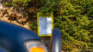
It was just before 2:00pm when I arrived at the USA-Canada border crossing at Nelway. I'd filled out my ArriveCan profile and was sure to have my vaccination card and less-than-72-hour-old Covid test results handy. I rolled up to the border agent with the shortest line I've ever experienced - there were exactly zero vehicles in front of me!

My conversation with the border agent was smooth as any I've had when in the Tacoma. I'm sure that the traffic volume meant that he was under a bit less stress than normal, and he worked his way through standard questions for the first few minutes - where was I going? How long would I be there? Did I have any firearms/bear spray/pepper spray/weapons. That kind of thing. Then, he hit me with his doozy - you know, the one that trips up Americans.
Agent: So [if you don't have any guns,] what are you doing for self-defense?
Me: (Pause, trying to parse the question.) Uhh, I have a very disarming smile?
Agent: (Incredulously.) You don't have anything to protect yourself?
This, I suppose, is where any proper resident of the United States would blurt out that - of course - they had a weapon for self-defense. Because seriously, if you aren't armed, then you're probably going to die.
Me: I guess not. I always find that the people I run into out on my adventures are pretty like-minded and totally awesome. I've never really felt any need to violently protect myself, have you?
Agent: (Handing me back my documentation with a bit of a sly smile.) Have a great trip!

If my border crossing had been a smashing success of navigation and route planning, that's where my deft skills ended on this trip. Of course, I'd done all the "normal" things to prep for the trip - building routes, downloading offline maps, and making sure I knew where I'd have the ability to get fuel - but I'd failed to verify the downloaded maps before setting out.
You see, the Accuterra (Neotreks Land Use) maps that I've loved so much in the US - since they include all the roads, as well as public land boundaries - were total crap for anything north of the border. There were no labels whatsoever - on roads, towns, etc., no designation of any geographical features - like lakes and rivers, and even the tracks I'd plotted - and verified in Google Earth - didn't overlay any roads on the tablet. It was a complete cluster.


We live and learn, and while I knew that it wouldn't be ideal, I had verified the routes in Google Earth prior to leaving, so I knew I could "drive-by-braille" and just follow my tracks, even if there was no background map at all, so that's what I resolved to do. After-all, I hear people used to go off without GPS tracks at all - imagine that! 
Anyway, the first several hours of my trip were on pavement anyway, and I'd decided that I'd make a slight detour - onto BC-3 and BC-3A - so that I could experience something that we totally don't have in the states - free ferries!

Known as the Inland Ferry system, there are 14 ferries that operate under private contract with the Ministry of Transportation and Infrastructure. All inland ferries are free of charge to users, and the Kootenay Lake Ferry is the longest, travelling 35km between Kootenay Bay and Balfour.

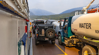
It turns out that you're only allowed a single, up-to-25L jerry can on the inland ferries, which I misunderstood as a single full jerry can when I'd read the web site. Luckily for me - and as would be true throughout the trip - Canadians are awesome and the friendly ferry loader quickly and easily found another rider who was happy to carry my second (empty) can.


After landing, I found a bit of fuel to top off my tank and fill up my jerry can - regardless of the high prices. This would become a common practice over the next few days, since I didn't really know my surroundings and wanted to make sure I was topped up in case my next fill-up was far away.
And with that, I headed north on BC-31 towards the little town of Meadow Creek in the West Koots.
It was just after 6:00pm when I turned off the highway and headed across the Duncan River towards my first trail up to Lavina Lookout. With an hour of sunlight left, I knew that I probably wouldn't make it before dark, but I hoped that it'd be a good spot to camp, and an even better spot to wake up in the morning to a fantastic view.
July 2024
The Argenta Creek Fire (N71058) raged through this area and burned the Lavina Fire Lookout to the ground. For more information, see Lavina Fire Lookout Loss | Four Wheel Drive Association of BC.
July 2025
The Lavina tower maintenance event is next Saturday, July 26. The road has been cleared of trees, we have an outhouse ready to go up, and heavy equipment will be on site to assist with the demolition of the old tower. This is not a beginner friendly trail and there will be increased hazards this year. We are traveling into a fire damaged area!


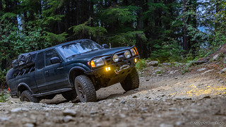
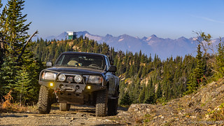
Initially, the climb up the mountain wound its way through the a reasonably dense forest. I expected this - logging is big industry in Canada - but it did make for relatively few views for the first several miles. Now and then, however, the road would pass a logging platform and I could see... a little further.

Sunset was a little after 7:00pm, and it was just after 7:30pm when I reached the ridge. It was only here that the trees started to thin - the 7,280-ft elevation right at the tree line, apparently.
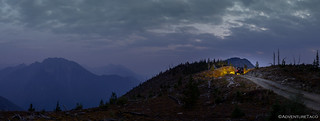

As I pulled up, I was excited to see that no one else was already camped at the summit - though I'd seen a nice spot not too far back that would have been a great backup - and that there was an actual camp site that I could call home. Being in a foreign country really had me second-guessing a lot of things I take for granted domestically.
I quickly set up the tent and tried to capture the last light in the sky.
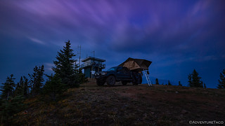

Having driven all day, I was ready to relax - climbing up into the tent to edit a few photos, and read a couple chapters on my Kindle Paperwhite before drifting off to sleep. As I did, lights appeared on the ridge and I could have sworn it sounded like a v6 Tacoma was approaching in the distance. Half an hour later, I wrapped up my screen time and turned out the lights, still alone at the top.
I figured - that having seen my tent light - they'd stopped at the first camp site, and were waiting till morning to come up and visit. With that, I drifted off to sleep, excited for what I had in store the next day.
The Following Morning...
Not knowing exactly what time sunrise would be, I just happened to wake up to pretty colors on the horizon, and grabbed the camera to my first morning in Canada.


I wandered around, happy to have my tripod and a fast f/2.8 lens for my camera. As usual, some shots came out great and others were mediocre at best. Some say that practice makes perfect, but I prefer to say that if you take enough photos, some are bound to be decent. 
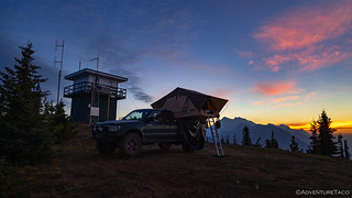


After enjoying the sunrise, I decided that I wanted to warm back up - though it wasn't that cold, 40°F or so - more than I wanted breakfast, so I climbed back into the tent and hit the snooze button on my internal clock for another 90 minutes. That made it 8:00am when I climbed out of bed for the second time to grab a bowl of cereal and check out the lookout in a bit more detail.
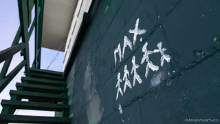
I'd read online that just a few days before I set off on my trip, that C.J. Hendriks was planning to try to tackle low hanging fruit in terms of work for the tower. Some painting, brush clearing, cleaning up any garbage, etc. I don't know exactly what he did, but the place was in great shape and still reasonably clean. Kudos to C.J. and the 4WD Association of BC who keep places like this up! 
After breakfast, I got everything packed up and pointed myself down the mountain. I was a little surprised to not have seen the vehicle I'd heard the previous night, but I figured I'd pass them on my way down at the very least.

Sure enough, as I approached the camp site a quarter mile from the lookout, there was a gleaming white 1st gen Tacoma, nicely outfitted, and... strangely familiar. I was of course too self-conscious to take a photo, and too shy to say anything about the wheels (which were a perfect match with mine), but had a great conversation with the folks who'd called it home the night before. Turns out, they'd just come from where I was going, and of course they were headed up to where I'd been. It was a splendid way to start the morning, and only later - after talking to Mike and asking if he knew any trucks that matched that description - did it turn out that he did. And, the reason I recognized the wheels was that they'd previously been Mikes! What a small world.

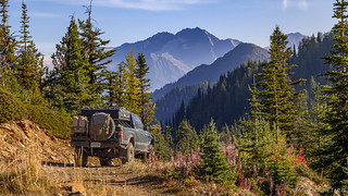
Our good mornings whatnot shared, I bid them happy and safe trails, and continued down the trail, excited to see what I'd missed in the low light the evening before. It was - as you can imagine - pretty fun, and I found that I actually liked running an out-and-back trail this way, since sometimes they can seem repetitive.


It was 9:45am when I reached the bottom of the trail and turned the Tacoma north on the Balfour-Kaslo-Galena Bay Highway (BC-31) again. Almost immediately - and to my joyous surprise - the highway turned to well-graded dirt, alleviating any desire to air up. Dirt highways are definitely a little different than what I'm used to south of the border!
I had about 50 km (30 miles) to my next trail - and let me tell you - it was going to blow my socks off!
The Whole Story


I don't always comment on every post but I read them each time. This one really struck a cord. As an ex backpacker in the back country of the sierra's and now for 30 years living in Florida, seeing the mountainscapes and the vista's blew me away. So close to retirement now and looking at different RTT 's (too old to sleep on the ground like those days) to mount on my double kayak trailer to explore this country & Canada. I did trek thru Banft & Jasper as well as Hell's gate in BC in my past.
Thanks for keeping me dreamimg and keep up the posts.
Awesome, glad to hear you're enjoying the stories Philippe! There are three more stories coming in this trip that I think you'll really enjoy given your experiences. It really was all about the mountainscapes and vista's this time! As for RTTs, you might be interested in this post where I wrote up my thoughts: Things to Consider When Choosing a Roof Top Tent (RTT).
Looks like an amazing trip so far. Love the photos and your blog style! Enjoy your trip here and next time plan a few days on the Prairies, you will be impressed with the night sky and sunrises! Cheers
Thanks Ward, I’m glad you’re enjoying the story, and hope you enjoy the rest of it as I post it. When you say “the prairies,” I’m not sure exactly what you mean, but I would love to visit on a future trip. Can you give me a bit more information? Thanks again, Dan
Good morning Dan;
What I mean about the Prairies is Alberta & Saskatchewan. I am biased towards Sask, as this is where I live. We have a reputation of being “flat bald ass prairie land” but I believe that comes from the fact that the TransCanada highway runs through the Southern part of the province and to be honest, it is a pretty boring drive! However, there are a few exceptions such as Cypress Hills and Grasslands Provincial Park which offer some unique scenery to the area.
In the Central part of the province you will get rolling hills but the sunsets and sunrises are spectacular. Living skies with incredible Northern lights can be seen that truly are spectacular! If you are here during the harvest season, the sights of combines harvesting is cool too.
The Northern part of the province is forest. Incredible lake fishing and calm peaceful nights with loons calling out truly is something everyone should experience. Glass water at sunset makes for fantastic pictures. Be prepared for mosquitoes though!
Ward
Moring Ward,
Well, that sounds fantastic! The description reminds me a bit of how I'd describe Montana down here in the states (though with slightly different orientations of the features), perhaps not all that unsurprisingly given the border they share! Rolling hills and Northern Lights - which I've never seen - sound fantastic. Sounds like I have a new destination to add to my list!
-d