
Having thoroughly enjoyed American Creek, I found myself both excited and apprehensive about the next leg of my journey. I was excited because Rady Creek was the reason I'd headed to Canada in the first place. I was apprehensive - I suppose - because I really wanted it to live up to the image I'd formed in my mind about how great it was going to be.
Looking back now, I was obviously over thinking things.
I'd heard about Rady Creek from Mike @POSTacoMike, who'd posted a video to TacomaWorld of a trip he'd taken to this special place just a few weeks earlier. Apparently, the trail was scheduled to be deactivated (on August 1, 2021), and the deactivation would make the road completely inaccessible to vehicular travel. I don't really know the ins-and-outs of the reasons behind the deactivation, though the Ministry of Forests, Lands, and Natural Resources lists the deactivation as a safety precaution due to instability of the road. As is often the case, there were plenty of folks who oppose the change, and had even started a petition to get the deactivation overturned. That petition is here (at least as of this writing), and if you feel that the reasoning behind it is solid, I believe anyone can sign it.
At first - after seeing the video - I thought there was no chance of exploring Rady Creek for myself, as it was already the tail end of August. But then, after reading the petition, I noticed an update:
Due to the ongoing wildfire situation in British Columbia and the redeployment of key engineering staff, I understand that the deactivation that was scheduled for this coming fall will be postponed until next year which will allow for further consultation and discussions to be conducted if needed with interested stakeholders.Garth Wiggill
Regional Executive Director
Kootenay Boundary Region
Well, that extra information was music to my ears, and less than two weeks later - just before 3:00pm - I found myself at the trailhead, excited to see a trail that might be closed forever.

Saying hello to the Jeepers, they let me know that we were all lucky to have met where we did - the trail becoming extremely steep just past this spot. That sounded great to me, though having run it now, I'm not really sure what they were talking about - the trail didn't seem any steeper than the others I explored in the area.


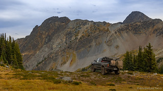
Unlike the tracks for Lavina Lookout and American Creek, track I had for Rady split near the top, and I decided to take steeper fork up the ridge, first. Less than 500 meters later, I popped out of the trees and got my first breathtaking view of the surrounding area.


Any apprehension I'd felt leading up to this first view was replaced with an urgency to explore - to see what was around the next bend, or over the next hill. I made a decision right then that slowing down was the right approach, and that the solution to any problem of rushing was just to spend the night up here.
The fork I'd chosen continued east, down off of the ridge and into a bowl. It was just the first of three bowls that I'd visit, and I eagerly headed down the winding road.

Not much further, I reached the end of the road. I'm not sure if this was always the terminus, or if the road used to continue further, but today a single track is all that continues on to the adjacent ridge. Curious, I thought I spotted a tailings pile through the trees, so I set off on foot until even the singe track petered out - the supposed tailings just a relatively consistent scree field on the far side of the bowl.
I headed back to the Tacoma, and retraced my path back to the fork in the road - noting a few possible camp spots along the way.
The left fork - which headed north, rather than east - skirted around the edge of a ridge. It quickly opened up to a second - middle - bowl, this one even more dramatic than the first.

Here, a maze of roads led to no fewer than 5 little lakes, each of them surely seasonal and historically the result of melting ice. There was no ice - or even snow - this year, and I found myself wondering if the days of these lakes are numbered, the earth warming them out of existence.

But Rady Creek didn't stop here - there was more. The road continued on to the north, up and around the far ridge of the bowl and I wasn't just going to settle down without exploring everything this place had to offer. Because, as I'd discover as I caught a glimpse down into the northernmost bowl, things just kept getting better.


Once again retracing my path, I navigated my way back to the northern bowl, where there were once again several forks leading to various mini-bowls and camp sites. None of them were occupied, and while it would be true to say that every site had tremendous views, there was one in particular that had caught my fancy as I'd come over the ridge from the center bowl.


And so, after exploring the roads and marking various coordinates on my map - perhaps a futile exercise if the trail is actually closed as proposed - I worked my way back to the spot that I'd call home for the next 16 hours. It was only 5:00pm, but I knew this was the place I wanted to pull out my chair and call it a day.


With camp settled and still several hours of daylight left, I did a little reading, a little rocking, and a little staring off into the distance. The entire time, a squirrel of some sort - I never actually saw it - chattered and chirped from a tree behind camp. Clearly, I was blocking his million-dollar view.  Eventually, the sun got lower and lower in the sky, and the light changed enough to rouse me out of my chair to grab the camera again for a few shots.


Clouds on the horizon would prevent a colorful sunset, but I didn't care. In fact, I'd climbed into the tent to make myself a little more horizontal as I read my book, and I think I likely slept through what would have been the colorful time anyway.  When I awoke, it was dark out, but still early - only 8:30pm or so, and I got ready for bed and snapped one photo that I was sure would be a reject before climbing into the tent for good.

This was easily the best night of sleep I got all trip. In fact, I awoke only once - at 10:18pm - feeling thoroughly rested, as though I'd slept all night - only to realize that I could go back to sleep for another full night of shut eye. It was such a nice realization, it almost felt like a gift!
When morning did roll around, I was once again up before the sun, so I could enjoy its entry over the horizon. Initially, as the light got slowly brighter, I found myself wandering the same general area that I'd been taking photos through the afternoon and evening, the only difference being lighting for many of the shots.

At some point though, I looked up and to my left (south) and thought, "Why haven't I climbed the ridge and looked over into the center bowl?" So I gabbed the camera and tripod and set off on the couple kilometer (mile or so) journey.


I probably spent an hour on the ridge, and it might have been my favorite hour of the trip. Watching the light change in the sky and across the mountains was fabulous, and it seemed I was taking the same photos every few minutes because, "OMG, look at it now!"


Getting up early turned out to be great. It meant that I had the time to soak in the sunrise, and still have a relatively early departure for what I knew would be a reasonably long day with a lot of miles to cover. So, I headed back down to camp and ate my breakfast as the sun continued to spill further and further into the nooks and crannies of Rady Creek.


Soon enough, the dishes were done and tent was stowed, and I headed back around the ridge to the center bowl.


Before leaving for good, I still had one more road to investigate - the shelf road I'd seen the day before - and boy, it was a doozy. You see, the road wound its way up the scree field - nearly to the saddle at the top of the bowl - and then faded into oblivion. It was as though whoever had constructed the road simply stopped a hundred meters from the destination. And by stopped, I mean literally, stopped. There was no pad to turn around or mine workings to be seen. Perhaps the road was worked this far and then snow blew in, shutting the operation down - never to be started again. 


Of course, the lack of turnaround at the top of the road meant that the only way down was in reverse. Luckily, I was reasonable sure this was going to be the case before I even started up the road - having seen it from several angles, including from above when I'd hiked the ridge - so I made sure on the way up that I wouldn't feel like it was too narrow backing down.

Upon reaching the main road, it was finally time to say my goodbyes to Rady Creek. It'd lived up to my expectations and then some, and I was extremely glad to have gotten here before it is (or may be) closed. As I tracked my way down the mountainside, I paused only a few more times for final photos, my mind working through options for the remainder of the day.


I popped out at Trout Lake, and BC-31, just before 9:00am. And, after a quick consultation with my nearly-useless offline GPS maps, I made a decision that would ultimately waste almost my entire day.
But that's going to have to wait for next time and the conclusion of my Canadian adventure!


Glad you were able to get up there, its such a beautiful chunk of earth. Shaun over at The Story Till Now on Youtube did a really great video about this trail a few weeks back. Definitely worth checking out. It's a shame that they close these places down as often as they do.
Do you happen to know if the road is still open this year Summer 2022)? My husband co-owns a US-based overlanding company. We are heading up that way in a few weeks. This trail looks amazing!
Hi Amanda, I've got no idea, unfortunately! I will say, however, that there was a lot more snow and cool weather this year, so even if the trail hasn't been decommissioned yet, it may not be passable until very late in the year - September or even October. And, that's assuming no early snow for next year! What a crazy one we've had here in the Pacific Northwest!