
Having thoroughly enjoyed my time on Rady Creek FSR, I popped out at Trout Lake, just before 9:00am. As had been the case the last couple of days, BC-31 here was smoothly graded dirt, and driving was a breeze. I really wanted to get down to the lake - a few hundred meters to my west and maybe a hundred meters down - so when I saw an offshoot, I took it.
As far as I could tell, the road I ended up on was the old highway to Galena Bay. Having fallen into disrepair since the new road - higher up the hillside - was constructed, the old ferry signs still stood along the roadside, vines slowly consuming them over time.

Back on the main road, it wasn't long before I reached the head of the lake and the little rural community of Trout Lake City. An old silver mining town that saw its heyday at the turn of the 20th century, the dirt turned to asphalt and I decided to air up. With several hours of the hard stuff in front of me, it'd make travel a bit easier on the Tacoma and save a little gas - which is not cheap in Canada - as well!

Back at full pressure, I pushed onwards, the highway curving around to the southwest and towards the Upper Arrow Lake Ferry terminal in Galena Bay. I have to say, I was just as excited to take this second inland ferry as I had been for the first, and I was once again happily surprised to find them still running on the summer schedule - meaning I only had to wait a few minutes before boarding.


It was after I disembarked the ferry that I had a decision to make. In planning my trip, I'd hoped that I'd be able to take BC-23 north through Revelstoke to the Mica Creek Dam, and then break off from the highway on my return route to climb up and over Pettipiece Pass - a trail that Mike @POSTacoMike had suggested - ultimately making my way towards Vancouver.

And so, confident in the fact that if - as I was getting up towards Mica Creek, I could take the turn to Pettipiece Pass if I was running short on time, I made a quick stop in Revelstoke, and continued on my way.

As I pulled out of Revelstoke, I was almost immediately greeted with a flagger in the road. Blasting and slope stabilization at the Revelstoke Dam meant that the highway was only open to traffic for a few minutes every hour, on the half-hour, so I had about 15 minutes to wait before I could proceed. Luckily, there was a viewpoint of the dam nearby, so I wandered over to take a look.

Soon enough I was back on my way - a little worried if I'd have enough time to do everything I wanted, but still enjoying the leisurely 90-100 kmh (~60mph) speed limits of the highway as it wound its way along the eastern edge of what used to be the Columbia River, and is now Lake Revelstoke.


It'd been 12:30pm when the highway had opened up to traffic, and so it was nearly an hour later when I found myself nearing the place where I'd planned to head west after checking out the Mica Creek Dam. The problem - obviously - was that there was an enormous lake between me and my trail, and last I checked, I wasn't driving a boat.
I started to get worried.
Initially, I figured that I was just missing something - one of the side roads must connect. After all, my map (the screenshot above), didn't show any "lake" blocking my path. Of course, on closer inspection, it doesn't show any lakes or waterways - a bit of an oversight, I'd say.
When I realized that I'd probably made a several-hour routing error, I also realized that "fixing" it was going to be time-sensitive. Because, remember, the highway was only open every hour, on the half-hour, to let traffic through. It was 1:28pm - so I'd driven almost exactly an hour - and I needed to head back now if I was going to make the 2:30pm opening.
But I wasn't quite ready to give up my search, and I continued north on BC-23 for another 5 minutes or so, checking out a final few dead ends. This only led to my time crunch on the return trip, and I soon found myself rushing back - the speed limit but a suggestion as I pushed the speedometer to the larger 90 I had on the gauge. What's the difference between kmh and mph anyway, amiright? 
Luckily, I made it - just in the nick of time - and followed the flow of traffic through the work zone before continuing another 90 minutes west on the Trans-Canada Highway to the opposite end of the Pettipiece Pass trail, where I had another decision to make - to run Pettipiece Pass, or to continue west to another trail I'd planned to run - and camp on for my final night of the trip - after Pettipiece?
Given that it was now only a few minutes before 4:00pm, I realized that the only reasonable decision was to scrap my original plans and go check out Pettipiece. Doing so would allow me to drive it in the daylight (one direction), which would surely be better than driving four hours west to a trail that I'd run entirely in the dark.
After a series of bad routing decisions, I'm happy to say, this was one where I made a great call.

To get to Pettipiece, I first had some 60 km of nicely graded logging road to travel. Mostly through the trees, the sweeping curves and smooth surface made for a fun time, my speeds creeping up higher than they probably should have.


Eventually, I covered the kilometers necessary to get to the trail leading up to the pass, and as I turned off the main route, I figured now was as good a time as any to air down. As I was, I snapped a photo that gives me hope for Rady Creek FSR - after all, if this trail is deactivated - and yet still travelable - perhaps the same will be true for Rady in the future.

The Pettipiece Trail, it turns out, was - or is, I suppose - a power line road. Following the high-voltage lines across the pass, it must have originally been built for their installation, though being deactivated now, maintenance must be via helicopter. At any rate, I'm not generally a fan of power line roads, but this the scenery of this one was nice enough to make me thankful that it'd been built in the first place, even if the crackling of static electricity was omnipresent overhead.


Unlike Rady Creek FSR and American Creek Trail before it, one never really got out of the trees on this trail. Instead, the road snaked through the landscape, crossing several creeks as it slowly climbed to the pass. The clouds made for some nice lower-light situations where I could play around with exposure and get some cool ephemeral shots.


An hour or so after turning off onto the Pettipiece Pass trail, I reached its halfway point and namesake of the route. Though still in the trees, numerous lakes dotted the landscape and views above the tree line were splendid. The colors - spring, summer, and fall all mixed together - made for dramatically saturated views in almost every direction.

A little further on, the road looped around a larger lake - this one, I believe sharing its name with the pass - and the calm evening made for a glassy reflection of the surrounding mountains and woods.


At this point I was headed back down the other side of the pass - alpine lakes and streams making for a visually stunning drive. Any reservations I'd had earlier about running this trail - rather than continuing west - were gone, and I was thoroughly enjoying the anticipation that came with every turn in the road. It was, however, getting late and I knew that I definitely wanted to eat dinner before it got dark; I find that clean-up, especially, is easier when headlamp is not required. But I'd come all this way and wanted to reach the end of the trail - directly across Lake Revelstoke from where I'd been earlier in the day - so I pushed the skinny pedal a bit more and eventually found my destination.

My get-to-the-end-of-the-trail urge satisfied, I headed back up with 15 minutes or so until the sun dipped below the horizon. I figured I had an hour of light after that for cooking and cleaning, so set my sights on the last lake I'd passed as I'd made my descent. There'd been a nice little camp site along the shore that would be the perfect spot to enjoy the last of the evening light before heading back to the highway under the cover of darkness.

Arriving at my dinner spot, I'd hoped that I could get dinner made and then enjoy it with a sunset light show, looking out over the lake. Just in case - and so I wouldn't have to eat and take pictures at the same time - I set up the camera to snap photos every 30 seconds and settled down for a relaxing meal.

My timing couldn't have been better. Plenty of light to cook, eat, and clean up, but by the time I reached Pettipiece Lake on my return drive, it was fully dark outside. My new Diode Dynamics SS3 fog lights did a great job of illuminating the trail in front of me, and the drive back to the highway - while slower than the drive out - was enjoyable.
The Following Morning...
By 10:00am the next day - after getting another great night of sleep at a spot I found along the way - I'd arrived in Vancouver where I'd arranged to pick up a few more Scepter Military Fuel jerry cans. These are super hard to find in the states, but much superior to any metal can, which makes me lucky to live so close to Vancouver where I can pick them up (relatively) easily.
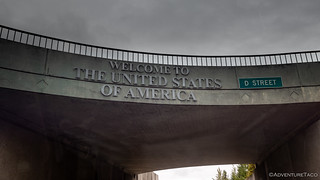
And then, just before noon, on September 11, I crossed into the United States in Blaine. The flags flying at half mast, and the display on the port of entry stating "United We Stand," it was good to be home.

In all, my trip had been everything I'd hoped for and more. The sights I'd seen along the way were stunning, and the experiences - with inland ferries, poor route planning, and fun trails - were ones I'll remember for sure. But the best part of this trip - even as I think about it now - were the interactions it allowed with our neighbors to the north. Everyone I'd met had been welcoming and warm. Happy to lend a hand in any way possible. That's what I'll treasure the longest this time - it's a mentality that I think we need more of in our world these days, and I'll be happy to contribute.
And Mike - thanks for all the help and suggestions!


Beautiful country, so much water everywhere and gorgeous mountains and the local people are wonderful. I use to cross the border at Hwy 95 and or Hwy 93 weekly. I also went to Alberta regularly also.
Thanks for sharing Dan!
You're welcome Kenny. Boy, you've sure gotten all over the place - I hope to have travelled as much as you when I look back on my life! Canada really does have a ton to offer, and is so much less crowded and more undiscovered (compared to all the instalanding that goes on in the US). Can't wait to get back up there again!
I have always liked traveling, I spent a year in the Army in Germany and traveled many other countries while there. I had a license to drive almost everything the Army had which allowed me to travel a lot for the Army. Where I was stationed I had an aunt and uncle in the same town and my great-grandma lived about 80 klicks away. I have also traveled a lot of Mexico and Central America. I have been really blessed to of met a lot of local folks as I didn't stay in tourist towns just local villages and towns.
Now I am getting old and tired so my travels are much more limited to camping and riding ATVs. I have a few new places I want to ride and camp next year that is new to me. I think the way you are exploring is exciting too, I have even given some thought to setting up a rig and doing some of the same, time will tell.
blessings,
Kenny
Next time, I'll be present! Glad you ran these. And there's a ton more east of these to hit too!
Glad I did too, thank YOU!
Another great story and set of photos Dan. Thanks again for sharing it all with us.