It was 9:45am when I reached the bottom of the Lavina Lookout trail and turned the Tacoma north on the Balfour-Kaslo-Galena Bay Highway (BC-31) again. Almost immediately - and to my joyous surprise - the highway turned to well-graded dirt, alleviating any desire to air up. Dirt highways are definitely a little different than what I'm used to south of the border, but they sure do make travel more pleasant - at least in nice weather!

Winding my way through the woods on BC-31.
My route took me along the banks of the Lardeau River. Along the way, a little information kiosk and trout spawning platform presented itself, and I stopped off for a quick look.

Crossing the Lardeau, you can see the kiosk on the right.
This stretch of water marks the start of the Lardeau River and the most important spawning site in B.C. for some of the largest trout in the world: the Gerrard rainbow trout. Goat Range Provincial Park, which is managed by B.C. Parks, provides protection for not only the sensitive habitat here at Gerrard, but also nearly 79,000 hectacres of surrounding high value fish and wildlife habitat within the Park boundary.
Adult Gerrard rainbow trout reside in Kootenay Lake. They often reach sizes of 75 centimeters (30 inches) in length and 8 kilograms (18 pounds) in weight. The largest, pulled from Kootenay Lake in 1976, tipped the scales at 16 kilograms (35.5 pounds). Unlike salmon, many Gerrard rainbows make the spawning migration multiple times and can live up to 14 years. The average life span, however, is likely between six and eight years.
Photo (and catch) by Nathan Ward.
There are many reasons for the incredible size of these fish, but the abundance of kokanee in Kootenay Lake certainly plays an important role. A large adult Gerrard rainbow trout may consume as many as six kokanee in a day. Not surprisingly, given the immense size to which these fish can grow, Kootenay Lake is a big draw for anglers, where up to 5,000 people annually spend 200,000 hours and $2.5 million pursuing Gerrard rainbows. Near the peak of the spawning run in early May, hundreds of people also visit this spawning site each day.
Adults ready to spawn migrate 65 kilometers up the Lardeau River to this site each spring in about 11 days and spend an average of seven days before turning downstream and returning to the Lake. Females dig a nest (redd) in the gravel with powerful stokes of their caudal fins (tail) before depositing eggs which are immediately fertilized by one or more males. Females then cover the eggs with gravel and the redd is complete. Females may repeat this process several times before their eggs, numbering between 5,000 and 11,000, are spent. Redds are visible over much of the spawning site as large (up to two meters across) raised mounds of gravel which are often lighter in colour than surrounding areas.Fish and Wildlife Branch
Ministry of Forests, Landsand Natural Resource Operations
Soon after my pit stop, my nearly-useless GPS maps indicated that I was coming up on the entrance to my next climb: American Creek. Nestled along Trout Lake in the West Kootenays, it was another trail that Mike @POSTacoMike had recommended I check out on my way to Rady Creek. Like Lavina Lookout the previous evening, I started out in the trees, winding my way up to higher elevations.

Lots of switchbacks.

American Creek was a tad overgrown. Helps to keep the riff raff out, I suppose.

Woo wee! The colors were bold and bright, and it was spring at higher elevations this far north.
As I got out to take a few photos here, I noticed quite a few butterflies flitting around. Most of them looked a little worse for the wear, so they must have been at the end of a migration or something. Still, there were a few that still looked reasonably healthy, sunning themselves and taking full advantage of the buffet before them.

Warming its wings.

This guy landed on the winch cable.
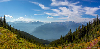
It probably took half an hour or so for me to climb high enough to start flirting with the tree line. When I did, I'm pretty certain that an audible "wow" escaped my lips - the view opening up in front of me and revealing the snow capped Selkirk Mountains to the west. Plus, I continued to drive up through a colorfully confused landscape - some flowers just starting to bloom as the huckleberry leaves took on their fall coloring.

I'd see a lot of the Selkirk Mountains over the next couple of days.

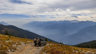
Driving through nature's nursery.
Besides all the color, one of the other nice things about getting up in elevation was that - while I wasn't completely clear of it - most of the smoke was once again below me, collecting in the valleys, and cloud-dabbled blue skies shined bright above. I must have stopped five or six times over the course of a kilometer just to soak it all in from various angles.

A little creek cascaded down the fold of the mountains.

Smoke snaked through the valley, flowing like the rivers it followed.
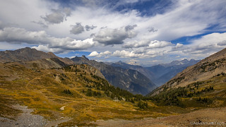
I continued to climb to something a little over 2,270 meters (7,450 ft) where the road skirted the edge of the mountain and trees a rarity on the high alpine tundra. I'd crossed international borders to see these views, and they were totally worth it.

Wandering along, fresh amazement around every corner.

Never-ending expanse as I continued to climb.
After cresting the ridge, the trail dropped back down and wound around a bit before climbing the final few kilometers to its terminus. It was here that I found a perfect little perch with an expansive view - clearly a favorite photo spot for more than just me!

Look...

...at that...

...view!
To this point on the trail, all of my views had been to the west, but the final climb took me once again to the ridgeline, and then dropped me down 50 meters on the east side of the ridge. As had been the case to the west, the views to the east were breathtaking. And there, another little perch backed a camp site with the most meticulous little fire ring I think I've ever seen.

View to the east.

Miles (sorry, kilometers) of mountains.

The Purcells, and Mount Templeton (I think) rising up in the very left of the frame.
I decided that this was the perfect place to have lunch - and not just any lunch. It was so nice up here that I figured I might as well make my should-probably-be-trademarked-tacorittos and just relax for a little bit. So, I pulled out all the kitchen gear and set up my new rocking chair, and enjoyed an hour of light breeze, (relatively) clean air, and the little mountain rodents running around on the rocks.

The view from my chair.
As I was wrapping up, a trio of motorcycles came buzzing up the trail - quite obviously having just as great a time as I was on this gorgeous day - and waved as they explored the various offshoots. Old mining roads, I'd later explore them as well - none of them leading very far before petering out.
It was 1:00pm when I decided it was time to pack everything up to start moving again. I'd seen the bikes head east over a small hill some fifteen minutes earlier, and wondered if the road was longer than I'd thought, or if they'd found something cool to look at. Whatever the case, I definitely wanted to check it out.

A pile of wood at the end of the road.
It turns out that - like me - the motorcyclists had really just spent a bunch of time staring off over the mountains, enjoying themselves and whatever conversation they were having. As I climbed out of the truck, one of them laughingly yelled down to me from an overlook that they'd found, "That pile of wood is mine!"
"You can have as much as you can carry!" I jokingly shot back, knowing that it'd be pretty tough for him to strap even one of the burley beams to his bike.
The wood, I'm sure, was brought up here at some point for mining operations - there were a few areas that clearly looked blasted and prospected, though I couldn't find any old structures or large tailings piles. Perhaps - as is the case with many prospects - the ground just wasn't as rich as the miners had hoped.
Ten minutes later, I was on my way back up to the crest of the ridge, knowing that I had a lot more to explore today and yet not wanting to leave.

Steeper than it looks.

At the very top, a final look east before I dropped back down the west side.

Also steeper than it looks, as I headed back down to Trout Lake.
As if often the case, the trip back down the mountain was significantly faster than the trip up. Gravity helps here a little, but the biggest factor - I think - is that I'm usually stopping less frequently to look around and take photos. What had taken a couple hours to climb, I descended in forty-five minutes, popping back out on BC-31 just before 2:15pm.
Perfect timing - it would turn out - for what I hoped would be the highlight of my trip. It was - at the very least - the reason I'd made the journey!


I love BC, use to travel there weekly in the '70s. Beautiful scenery, lots and lots of water and great people, just like family.
Enjoy your trip.....
Thanks Kenny! It sure is beautiful country up there. Seems like finding trails and "things to see" is a little harder than south of the border - more is shared via word of mouth than via the internet - but I suppose that's both good and bad, as it helps to keep the places a little more pristine.
Hope you're also enjoying the tail end of summer/early fall in your adventures. Hopefully we'll get some snow (and rain) falling soon across the west to reduce the fires and smoke.
So glad you made it!! And next time, i'll make sure I have time!
I can't wait. And I'll happily schedule around your "time," since I won't be in such a rush to run a trail before it closes! Thanks again for the tips and pointers, and let me know when you're headed south, so I can show you the desert.