
I think we left off with our adrenaline pumping and three trucks parked right outside our tent, one of the occupants having just said, "What the f*@# is going on here?"
Climbing down out of the tent, I walked over to the guys - all still clustered around their vehicles - to say good morning and ask if they were, as I suspected, workers on this particular construction site. It being a Saturday morning before 6:00am, I hadn't expected to see any workers, but I guess when houses are selling like hotcakes, every minute you're not building new ones is money down the drain.
It turns out that they were in fact workers at the site, and that - to me - was a blessing in disguise. I mean, sure, it was a little weird and perhaps a little embarrassing to be caught parked and sleeping in amongst their equipment, but it also meant that I could ask some locals for a bit of help in accessing a trailhead that is now notoriously hard to find given all the new development.
My satellite imagery suggested that an old BLM road started near our current position, and when I asked the guys if it was OK to drive past the construction signs to access it, the affirmative response I got was enthusiastic. "It's super cool up there, go have a great time, man! The construction company put up all these Private Road signs because they don't want people to get in the way of the heavy equipment, but you're more than welcome to go up there exploring."
And with that, we cut four hours and eight miles of tedious alluvial fan hiking out of our day. Awesome.
By now, @mrs.turbodb was out of the tent and I quickly got it put away, thanking the guys for the info as we pulled onto a short connector to the road that would take us to the edge of Red Rock Canyon National Conservation Area.

Blue skies and expansive views in front of us.

The sun glowing down on the Las Vegas strip behind.
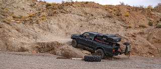
We didn't make it far before we found a crippled Ford just out of the middle of the road. Likely bombing around at night, this guy had some bad luck when the uniball in his upper control arm failed, and his spindle started crashing around in the wheel well. Really, he was probably lucky that more damage wasn't done.

The Tacoma looks so tiny next to a full-size F150.

And with this photo, I stoke the internet fire of uniball vs. ball joint. I'm sure glad I went with ball joints. 
There wasn't much we could do to help without the owner around, so we continued on our way, remarking time and again how lucky our choice of camp site had been. Not only did it cut down on the length of our trek, but it also meant that we were making tons of progress way earlier than if we'd camped where I'd planned - some two hours away!

In there, magic awaits.

A muddy hill, eroding into its own miniature badlands.

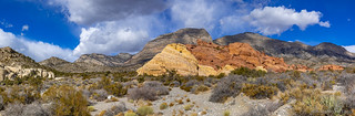
Red Rock Canyon - appropriately named.
Several miles later, we reached the end of the road and the border of Red Rock Canyon National Conservation Area. Our elevation had increased by nearly 1,200 feet, it was 7:03am in the morning, and we'd done it all in just under 15 minutes. Time for a well earned breakfast!
I guess now would be a good time to fill everyone in on what we were doing here in the first place. You see, I'd gotten wind from various bits of research that this particular canyon - ██████████ Canyon - contained a few panels of multi-colored pictographs. Pictographs are - by their very nature of being pigment on rock - more fragile and rare than petroglyphs, and usually when we're lucky enough to discover some, they are a monochromatic - usually using red or black pigment. Needless to say, I was excited.
I was also a little worried. You see, these glyphs are well-known enough that I could find photos of them online, as well as a general location in the La Madre Mountains, but like several other reasonably unique sites, specific locations within the larger region were undiscoverable. What if we'd come all this way and didn't find them?
As always though, the hunt is a big part of the fun, so we set off - our spirits high, our fingers crossed, and the sun at our backs. Oh, and our heads were on swivels. It didn't take long for us to make our first discovery!


A couple of enormous panels high up on a red sandstone wall boasted a series of geometric shapes and lots and lots of dots. Petroglyphs rather than pictographs, we were still plenty excited - it's always nice to get an early win in a hunt like this! Unsure if we'd find more in the area, we spent a good amount of time climbing around these panels - careful where we tred so as to not step on any rock art - but found only one small panel containing a hand and a couple other glyphs.
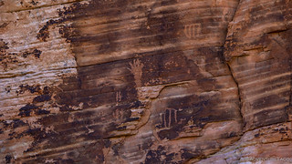
If our spirits were high when we'd set off, they were through the roof at this point as we continued up the wash. The geology here, too, was fantastic, and we found ourselves stopping to admire it nearly as much we did for the rock art that was our ultimate objective.

Pinched - in several places - yellow sandstone. How does this happen?

View of the main canyon from a tank up a short side canyon.

Light. And dark.
Also along the way, we discovered panel after panel of petroglyphs. So close to Las Vegas, these were hidden in plain sight and I hope that anyone lucky enough to visit understands the responsibility that comes with the knowledge of their location.
Here are a few of my favorite panels:
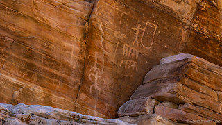
Man with shield.

High panel.

Familiar patterns.

Time is the enemy - portions of sandstone are slowly eroding away.
Each of these panels were high on the walls surrounding the canyon, and it was fun to work out how the artists had reached the narrow ledges that enabled their work in the first place. After climbing to a few of the panels for a closer look, we realized that this work was meant to be viewed from the wash - our new perspective just a few feet away, making them almost indecipherable!
We resumed wandering, wondering how long it would be until we stumbled upon the panel we were really after. The panel that was painted rather than carved. The panel that we may never find.
Except that we did!

Oh, the colors.
It's hard to describe how colorful these pictographs really were. The saturation - after all these years - was astonishing. And the quantity - there were so many. Stretching over a series of panels that must have been 60 feet long, there were several clusters of familiar geometric shapes and figures. Quite obviously, a single group of people created both the petroglyphs we'd seen already as well as these paintings.

Multi-dimensional panel.
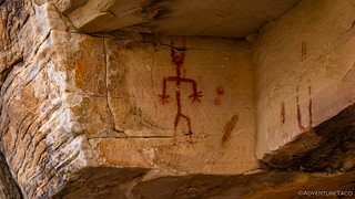
Wolverine man.

Human or reptile? Perhaps proof of early lizard people 
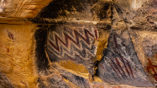
Polychromatic zigs.

Brilliant red.

I just couldn't get enough of this panel.
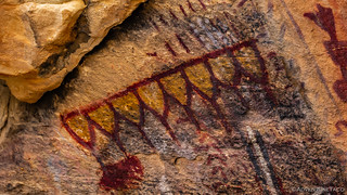
I don't know that I've ever seen yellow in pictographs before.
Sufficed to say, we were both quite happy to have found this special place, and we briefly considered turning back at this point since we'd reached our objective. Luckily, cooler minds prevailed, and we continued up the wash - the namesake outcropping highlighted as the sun broke through the gathering clouds.
As we neared this outcropping of color, I thought it'd be super cool for @mrs.turbodb to straddle the yellow-brown seam, and she obliged by climbing up the steeper-than-it-looked face to find a reasonably comfortable perch, high above.


We didn't find any additional petroglyphs on this formation, but we did find views nearly as exciting - the dark canyon walls, a stark contrast to the brilliant colors at the bottom of the wash.

Eventually though, as the clouds continued to gather and the winds picked up dramatically, we looked back from whence we came and decided that we'd better get a move on. We had a couple more places we wanted to explore before calling it a day, and though I should have realized there was no real chance of beating the weather, I was hoping catch them both under sunny skies, rather than clouds.

Our walk down the wash reminded us just how close this place was to way too many people.
It was 10:45am as we headed back to the Tacoma, and we'd spend the next 90 minutes or so navigating our way through Las Vegas traffic as we worked our way east towards the Muddy Mountain Wilderness. Our navigation initially routed us along some sort of toll road, but with a bit of finagling, we were able to determine that Lake Mead Blvd would get us where we wanted to go just as quickly and without an extra payment. Well, except for needing a pass to get into Lake Mead National Recreation Area - easily accomplished with our America the Beautiful Pass.

Just inside the entrance station, views.
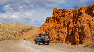
We were starting to get a little hungry as we traded smooth pavement on Northshore Rd. (NV-167) for the much rougher Anniversary Mine Rd. For the first time on the trip, we took a moment to air down.
Not rougher, yet.

Well, that's a bit of drama for you.
Our ultimate destination on this leg of the trip was a narrow slot canyon just past the Anniversary Mine, but I'd had no idea when I created the route that we'd be squeezing through the bottom of a narrow wash to get there. It was fabulous.


We arrived right around 1:00pm, to what was clearly one of the more popular places we'd visited so far. Situated in Lovell Wash - a different wash than the one we'd driven to get there - Anniversary Narrows was accessible from both the east and west, though there were approximately two dozen people accessing it from the east, and just us from the west. The reason became obvious to us later: access from the east was significantly easier along a well graded gravel road!
In fact, we were happy to be alone on our side of the wash and @mrs.turbodb set about the assemblage of tuna sandwiches, while I gathered up my camera equipment and munched on potato chips. It was a rough life, eating chips while someone else makes your sandwich, let me tell you. 
As it had earlier in ██████████ Canyon, the clouds continued to push in here as well, and we rushed through our lunch a little more than I think we'd have preferred in an attempt to get going on our hike into the slot canyon before the entire sky was gray.

Even before we reached the narrows - perhaps half a mile up the wash - we were treated to some glorious geology. Folding, uplifting, and even strange circular formations lined the walls of the wash. Oh, to have a timelapse of the last billion years or so that I could play back and watch everything unfold.

Folding under pressure.

There were only two of these circular formations. Perhaps once a pool, eventually tilted from horizontal to nearly vertical?
And then, the narrows. Unlike many slot canyons where the walls are worn smooth - or are at least smooth from a distance, the walls of Anniversary Narrows are composed of numerous thin limestone and mudstone layers angled at nearly 45°.
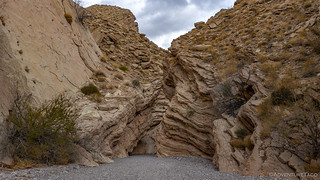
Entering the narrows.
While not as tight or deep as some other slot canyons, the tight turns and angled shelves made for an enjoyable experience as we worked our way up the narrows. At one point @mrs.turbodb got a bit ahead of me - the slow poke taking photos - and I came around a bend to find her perched high on a shelf, waiting.

Bird's eye view.
As cool as the narrows were, there was one drawback - their popularity. We'd managed to work our way perhaps 500 feet into the narrows before running into any other people, but all of a sudden we had folks approaching from both directions. The slot canyon making for an essentially enclosed space, we quickly donned our masks and moved over to keep our distance, somewhat expecting others to do the same.
Nope. We were technically outdoors, and I'm not really sure what the mask tendencies in the Las Vegas area are, but it was immediately obvious that we were going to be in the minority from a masking and distancing perspective on this hike.
We pushed on around the next few bends.

Eventually though, two things became clear: first, as the slot got narrower, the crowds got tighter; second, it was starting to rain. Mentioning to @mrs.turbodb that it was probably in our best interest to turn around in case it really started to get wet (and muddy) and because there was no reason for us to risk exposure to someone unknowingly carrying covid-19 just to see a slot canyon, we turned around after about 70% of the narrows and headed back toward the Tacoma.

Looking downstream, the light played entirely differently off the canyon walls.
Just as we exited the slot canyon, the first of several 50mph gusts whooshed out behind us, blasting us with sand and pushing us forward - a good indicator of how parts of this canyon were formed. Neither of us dressed for this sudden change in weather, we picked up the pace and soon found ourselves back at the truck, the rain really starting to come down.
That wouldn't usually have been any sort of problem - and hopefully it wouldn't be this time - but there was one reasonably technical obstacle to overcome in order to climb up and out the east side of Lovell Wash - another reason that most folks approached from the east, and never made it to the west.
Of course, an obstacle like this always looks easier on camera, but careful tire placement was necessary to make this work.
And with that - as everyone else seemed to scatter for home - we hoped the rain would pass quickly and set off to our next destination just a few miles away: The Bowl of Fire.

The brightly colored red, pink and orange Aztec sandstone seen most prominently in Valley of Fire also occurs at other locations around the north and west shores of Lake Mead. We'd been to a couple of these on our trip a year earlier at Whitney Pockets and Hidden Valley, but we'd never visited - or even known about - the Bowl of Fire. Here the rocks are exposed at the foot of a steep limestone ridge on the north side of Callville Wash, and are accessible via a 4wd road and a three mile hike. Perfect!

We were treated to a mint green mound of limestone with our first view of the bright red Bowl of Fire. Now, if only the sun would come out!

This is how they make mint chip ice cream. Allegedly. Allegedly.
It had only been 45 minutes or so since the rain in the slot canyon, but the strong winds had already blown the moisture through and while the gusty winds remained, it was now totally dry with some sun breaks. Eager to get going, we parked the truck and started up the wash that would allow us access to what we hoped would be a fabtacular view of some amazing orange rocks.

Yep, worth it.
When you get to a place like this - a place little visited and yet totally spectacular - it's easy to get lost as you wander around, trail-less. So, we did. Well, we wandered around anyway, we didn't actually get lost. Not that we'll admit to the world!

Little arches.

Vibrant desert shrubs.

Sandstone tafoni wind caves. Or, elf windows.

Elephant arch.
Though many times smaller than Valley of Fire, the Bowl of Fire could have kept us busy for days. Part of me wanted to come back the next morning - hopefully with the sun shining - but we realized that for all we knew, the weather could take a turn for the worse and so it'd be better to just stick around a bit longer into the late afternoon while it was at least dry.
This turned out to be a great decision, the sun eventually creeping low on the horizon, illuminating the orange rock against dark storm clouds.

Layers.

This mountain is on fire!
Of course, we couldn't stick around forever, and knowing that we still needed to find camp for the night, we set off towards the truck around 4:30pm - half an hour before sunset, with maybe another 30 minutes or so after that to find camp.

Heading back towards whence we came.
The sun continued its display once we got back to the truck - clouds always such a mixed blessing in my mind when it comes to adventure. On the one hand, they generally indicate less-than-perfect weather. On the other, they sure add a lot of visual interest to every element of the landscape!

We found camp - in a hopefully-wind-sheltered area along the side of Callville Wash - at the peak of sunset, and I took a few photos before setting up the tent and tying our 5-gallon water Jerry can to the ladder - the wind gusting to 45mph, enough to blow the tent shut without the extra weight!

Dinner was my - our - favorite of the trip. A Vietnamese Bánh mì inspired chicken sandwich that @mrs.turbodb has been making recently and that consists of marinated chicken, and spicy (jalapeño and habanero) pickled carrots and cucumbers, along with a bit of mayo and cilantro on a hoagie roll.
I always eat two.
For a while after dinner we read our books and caught up on a bit of photo processing in the cab of the truck as the wind rocked us back and forth, our hope that it would subside dwindling by the minute. Eventually, we realized that waiting out the wind wasn't in the cards, so we brushed our teeth and climbed into the tent - earplugs at the ready.
Not that they'd help all that much. This was going to be our worst night of sleep during the entire trip as we fought to keep the tent from eating us alive. Oh, and the sand. But we'll get to that, next time!


 - Mid-Winter #4")


Thanks for the post!
The last four hikes I've blogged (as of today, 3/16/2021) have been around the Bowl of Fire. Drop by, if you get a chance: https://myown100hikes.blogspot.com/
Within the posts, clicking on the small images opens a larger version of the photos.
Nice! I'm checking out your site now! Have fun and stay safe out there. ?
Thanks for sharing, postcard-worthy photos. Hard to imagine this is this close to Las Vegas, keep up the trekking and the photos, we love them.
Thanks so much Kenny, glad to hear you enjoyed the photos!
Always love your posts!!!
Where’s the entry into the short cut around the new developments? Is the full size Tundra OK for your route from the west on Lovell wash - Anniversary Narrows?
Great to hear you're loving the posts David! As far as the access goes, I've written as much as I'm going to say on that in the story, given the sensitive nature of the site - not so much to keep the shortcut secret, but to protect the jewels of the hike. You can see my thinking/approach on the topic here: https://adventuretaco.com/do-you-have-a-gpx-for-that/
For Lovell Wash - a full size Tundra would have a tough time coming from the west. From the east should be fine, however.
You have the best blog. The wife and I are taking next year off to travel and your blog has been really helpful in planning our trip. If you want a GFC alternative we'll have a Flippac for sale in May we'd love to send to a good home.
-Thanks again!
Thank you for the kudos Charles, always nice to hear when folks are enjoying the stories! What are your plans in place of the Flippac, and why?
We're getting a FWC because we're going to do a few ski trips and dont want to freeze to death in the Flippac, which isnt much warmer than a tent...
Gotcha. Those FWCs are definitely a luxury on wheels! Boy, I'd love a Flippac for the size, and I like the idea of sleeping out over the cab, but one of the things that has me looking toward GFC is the wind profile, and presenting a nice hard wedge into the prevailing wind. That's probably my 2nd biggest "gripe" of the standard RTT is wind noise! (the cover zipper being the first)
I hear that, and the Flippac is pretty loud when its windy. Sleeping over the over that cab is pretty sweet, tons of room for storage in the truck bed. A friend of mine has a GFC on a 1st gen Tacoma and he complains less about the wind noise.
Thank You for sharing your beautiful adventures and also for not disclosing gps coordinates. I’ve been blessed with an opportunity to spend the last 25 years exploring remote areas of the desert Southwest and have seen firsthand what happens once a gps location exposes historic and treasured desert gems.
Glad to hear you're enjoying the adventures Louis. I'm sure you've had some splendid ones yourself in the last 25 years, and I can only imagine how things have changed.
If you ever feel that you have a place you think I might like, by all means let me know, and I'm more than happy to keep its location (if I'm able to find it, and experience it myself) under wraps. ?
I'm reasonably certain that the "pinched" sandstone is a classic crossbedded sandstone formation. Lithified sand dunes, deposited at angles to one another. It's a fantastic example of one, it seems.
Thanks for the additional info! So interesting how the dunes were both at different angles as well as different colors of sand deposited over time! It's so great when someone more knowledgable comes along and can share more info than I was able to. ?