
My exploration of Blue Valley complete, and a bit of my curiosity satiated at the Hattie Harrell Homestead, it was time to scratch another itch that had been bothering me for more than a year. On the same trip where I'd seen the Harrell Place across the river, I'd spotted a road high up on the eastern escarpment of the canyon. A series of switchbacks, I made a note to investigate when I got home.

I year earlier when I spotted this zigzag I thought, "Doesn't that look intriguing!"
Making my way back up through Blue Valley - completing yet another of my out-and-backs - I soon found myself overlooking the descent back down into the canyon at access road to the Christine Marie Mine. Unfortunately, by this time, it was raining.

A tempting plunge, but a difficult climb if it becomes a muddy mess!

If the Pollock-esque pattern on my door was any indication, I wasn't in for a clean afternoon.
Looking out over the canyon, the weather situation didn't look promising. Or did it? There seemed to be rain everywhere around, some places heavier than others. But then - far to the west - I could see what appeared to be rainless skies; not cloudless, but dry. With a brisk westerly wind, I crossed my fingers that the ground would still be dry enough upon my return and drove over the edge toward the mine. If I was going to do this, I was going to be quick about it.
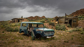
On a small plateau above the switchbacks, the old cabins for the mine as well as an old International Harvester Scout 800 stood guard over the site.

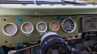
Axle seals anyone? Castle nuts?
Barely broken in, mileage wise!

Jake's cabin was set into the hillside - likely to moderate temperatures and shelter from the driving wind.

I really liked the rockwork-woodwork combination. I don't feel like I often see this attention to detail in miner's cabins.
With the rain increasing, I started to wonder if I'd made the wrong decision. Even a quarter inch of water on the Owyhee mud could leave me stranded until things dried out. But I'd come this far - and curiosity is a beast - so rather than retreat, I rolled the dice and headed to the top of the switchbacks. "I'll just take a photo from the top," I told myself, and then beeline it back to the relative safety of the plateau.

"A photo from the top."
As I'm sure everyone reading already suspects, upon reaching the top of the switchbacks, I couldn't bring myself to turn around. "I'll just descend to the first turn," I decided.

"The first turn."
Well, at the first turn, I could see that there were only a few more to what appeared to be the main mine workings, and after a bit of hmming-and-hawing, I convinced myself that I could be quick about a trip down to check them out. I'd later discover that these were the workings of Jake's Place, and not the Christine Marie Mine.
For more information about the Christine Marie Mine and the man who worked it - Eugene Mueller - I have some recommend reading. Years after working the Christine Marie Mine, Eugene put together a blog containing several of his stories. I wish I'd discovered his blog before heading out on my adventure, but having only discovered it once I returned and was doing some research for my own story, I knew I needed to share to those who enjoy my adventures. His writing style, as well as the background and detail on this place, are fabulous. Read a few pages or the whole thing; I don't think you'll be disappointed.
The Whole Story


I soon reached the workings about 700 feet down the hillside. This, it turns out, was known as Jake's Place.

It might appear that copper was the goal at the Jake's Place - and by extension the Christine Marie Mine - but it wasn't. Morrisonite Jasper was the ultimate prize.
The views from the workings were spectacular. To the northeast, the storm that'd been passing overhead continued to dump buckets across the landscape - my earlier hope that the clouds would add a bit of drama, easily fulfilled. To the southwest, it was still cloudy, but - as I'd hoped - dry, the green landscape below, now devoid of any dust, somehow even brighter than it'd been earlier in the day.

Into the storm.
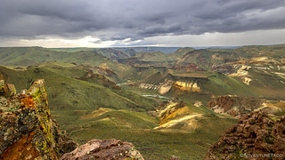
Blue Valley has never been greener!
Eventually - though in less of a rush, as it wasn't raining at the moment - it was time to make my way back up to the top and on to my final destination for the day - a second set of petroglyphs that I'd apparently passed by many times before! And so, up, up, up, I went, surprised at how quickly I'd made it down, and now slowly I was making it up the old mining road at the Christine Marie. I can only imagine driving this road in the old International Harvester Scout, hoping that it would make it with a full load!

On the way back up, I detoured to check out a small cave on the hillside.

Relative safety of the flat ground. At least here, muddy trails would only lead to a muddy truck, rather than the risk of sliding down the hillside!
From the mine, I had only about five miles to the site of the petroglyphs - somewhere long the circumference of Jordan Craters. Then, as I slipped and slid my way across the just-wet-enough-to-be-sloppy roads, I spotted a truck up ahead. Initially I thought it was someone out hunting, but as I drew closer, I realized it belonged to a rancher, working their fences. Likely having bugged out a couple hours earlier when the rain had started - some would say, in the way I should have - they'd left the job for another day. I climbed out to take a look.

An old Dodge M37, the military version of the Power Wagon. Sharing the same same chassis, drivetrain and most of the body, the biggest difference was that the M37 had a rag top, and the PW had a full steel cab.

I loved this sticker on the inside of the door. If only drivers today still took such pride in their practice.

Now, with nowhere to put a key, how do we start this thing?
(Note: I never figured it out, and wouldn't have, even if I had.)
After poking around a bit - hoping that the owners would come return so I could gush over their rig for a bit and learn a bit more of its history - I eventually pulled myself away and was soon trekking cross-country through the on-again rain towards the edge of Jordan Craters. I'd never approached from this angle before, and with the green grass of spring, it was quite the dramatic view into the blackness of the flow.

On the edge of a lava lake.
I searched around for the petroglyphs for a good half-hour or so, finding several places where they should have been - nice patina to the rock, smooth faces to etch on, etc. - but never actually finding the rock art I was after.

While I didn't run into any rock art, I did startle this little guy. Of course, he let me know he was there, and I gave him plenty of room. (Great Basin Rattlesnake)
Finally, with the rain increasing and a realization that I could always come back for a more thorough search, I headed back the way I'd come, toward the Tacoma. With only 20 miles between me and the highway, I decided that I'd push towards home a bit - hopefully out of the rain - before finding a spot to get some shut-eye in order to break up the ten-hour journey. It'd been another fabulous trip to the Owyhee Canyonlands - one I would not soon forget.

Airing up in the rain, always a joyous experience.
Spring Flowers of Day 2

Showy Phlox

Lupine.

I thought the lupine leaves were just as pretty as the flowers!

Red-stemmed Filaree

Fiddleneck

Bitterroot Lewisia
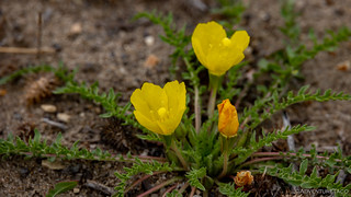
Evening Primrose

Apricot Mallow


As always, a good adventure and excellent photos! Thanks for sharing. BTW - Did that old military Dodge have a foot starter by any chance? My old 49 GMC had a foot starter near the gas pedal but it also had a ignition key since it was a civilian vehicle. Turn on the key and then put down (hard) on the foot starter to turn over the straight six engine.
Hi John, as always I’m glad you enjoyed the story, it’s great to hear from folks like you when you do!
You know, I don’t know if there was a foot starter on that truck, but I do recall there being quite a bit of stuff on the floor to muddle through with one’s feet. I suppose that I’ve never seen a vehicle with a foot starter before, so I wouldn’t have recognized it if that’s what it was. Given that there was no key, it seems likely that you are correct. I’ll have to go look around on the Internet a little bit for old vehicles with foot starters, because now I’m curious.
Yes, I learned to drive in an old pickup truck with a foot starter back in the 1960's but even then they were scarce. I think they disappeared in the early 1950's. I learned in a 1949 pickup, my Dad's old work truck. The foot starter also known as the "stomper" was a small round pedal on the floor to the right of the gas pedal. The truck also had a long handled floor shifter. An image can be found here https://classics.martinsauto.com/cgi-bin/md/M11013/footbuttonstart.s21.pl
This is another one of my favorite places to explore, old homesteads spotted throughout the country with lots of history. From the Christine Marie mine, a couple of the guys thought they would continue on up the hill and around only to come to a locked metal gate placed by the BLM.
Did you make it to Jordan Craters? Once I was standing on the edge looking down into the crater when a buddy told me I better back up as I was standing on a ledge. Interesting as I moved back and around the rim I saw how if the ledge were to break off it would have been my gravesite.
Great story bringing back fond memories of the area and as always postcard photos.Thanks Dan!
You’re welcome Kenny, glad you enjoyed the story and photos, and that it was able to bring back some memories for you.
I made it over to the lava flow and Jordan craters, which were the last couple of photos above, but I didn’t go to the cones themselves this time, as I’ve been there before and I was in search of the petroglyphs on this occasion. Since I didn’t find them, I’ll have to go back when it’s not raining and spend a little more time looking for them.
Great photographs and narration as always! I enjoy the historical, geologic and nature insights mixed in. Just got back from my first trip to the Owyhee Canyonlands. Didn't get as far south as Jake's Place and the Christine Marie mines. Now I'll need to head back down. Really enjoyed reading the excerpts from Gene's mining experiences. Not sure I would have attempted the switchbacks after reading his road building accounts.
Thanks Joe, and sorry for the slow reply, I’m out on the trail at the moment. Just happen to have service, and saw this comment from several days ago, ha ha ha.
The roadbuilding was certainly an eye-opener, and I must say, he did a fantastic job. With modern vehicles, it’s a much easier proposition then with his old Scout! Well, assuming your vehicle isn’t too long, that is! ?
Long-time stalker, first time commenter. Love your work. I'm headed to the Owhyee Upland Backcountry Byway (in Idaho) this weekend and there's rain in the forecast. I'm trying to get a sense for how much (or how little) rain it takes to get into trouble out there.
Thanks!
Chris
Welcome! Always nice to get a first post ?. As far as the main Owhyee Upland Backcountry Byway goes, you'll be fine even with quite a bit of rain - it's a very well graded (gravely) road, and I think it'll drain well (enough) that you won't have any issues. Now, once you get off the main byway - onto the spur roads (if you're planning any of those), you can be in for a slick mess with as little as .25" of rain. Really, it'll depend on how quickly it falls, how saturated the ground already is, and the specific road you are on.
For this next specific weekend, given the forecast I see in Silver City, I would still give the trip a go. The good news is that you'll know pretty quickly if it's going to be a problem, so you can usually back out (or get back to the Byway) with enough time to not get really stuck. Well, except for the never-ending issue of getting the Owyhee mud out of all the crevasses of your truck when you get home!
Have fun out there. I'd love a follow-up comment with how you liked the area and what you discovered while you were out there! ?
Had a great trip. Got into Jordan Valley Friday morning and enjoyed a full (slightly smokey, but dry and sunny) day exploring. We did a total of 63 miles that day, which took just over 6hrs (only 43min stopped). We headed SE out of Jordan Valley, up to South Mt. and onto the northern border of the North Fork Owyhee Wilderness. We intended to carry on east from there, but got turned around by an prescribed burn that the state was lighting off right in front of us (about 35mi in). Terrifying at first because we thought it was wildfire. We scooted SE for the remainder of the day. Ran into several nasty thickets of "pin-stripe brush" as we call it as we followed a fairly slow and technical ridgeline back out to the official OUBB road. Exhausted from 30+mi of slow, technical riding we crashed for the night at Owyhee Northfork Campground (free).
It rained way harded than forecast all night, so we didn't even think about going back out on Saturday. My co-pilot had never been to Steens Mountain, so we shot over there for the day. Had a fun out-and-back on the north end of the Steens loop, right in the middle of 4"+ of fresh snow. Enjoyed a delicious home-cooked meal at the historic French Glen hotel and then sought refuge for the night in a cabin at the RV Resort rather than endure a night of 20 degree temps in the truck.
I have to say, that sounds like an awesome trip. I bet Steens was *beautiful* with 4" of new snow! Easily passable, and yet such a nice white blanket.
Hopefully it whet your appetite for more. I'm hoping we can head over to the Hart Mountain area (west of Steens about 50 miles) for a few days in the next couple of weeks. Would be cold nights (as you ran into) but still fun to explore.
Hi Dan,
As always you have shared a great trip report with us. I still have quite a few of them to catch up on, but this one caught my attention because my dad, my son and I were out in the Owyhee (Three Forks - Jordan Craters area) for the first time this past June (2nd and 3rd). We actually did what I call the Great Western Loop based on a lot of the areas you have shared through your site. Having gotten a small taste of this area, I'm going to have to go back and really spend some time exploring it. Thanks again for always sharing your adventures with us all. Maybe one day our paths will cross out there somewhere.
Thanks Keith! I would love to see more about this "Great Western Loop" you did in Owyhee - if you're willing to share. (Email is fine, rather than posting it publicly - whatever you prefer).
Owyhee was one of the first places that @mrs.turbodb and I visited, and we had no idea at the time how much we would enjoy it. We've been back SEVEN times now, and each time there is something new to explore!
You can see all the trips (if you don't want to happen upon them as you "catch up") here: https://adventuretaco.com/tripdest/owyhee/.
The region (as you may know) spans Oregon and Idaho, and a little bit of Nevada, but I've mostly focused on the Oregon (and a bit of Idaho) portion. My nomenclature is:
Also, if you enjoyed the Owyhee Region, I encourage you to check out the Alvord Desert and Steens Mountain. Nearby and fabulous!