We had unfinished business in Utah, after our Ruining Around Utah trip back in spring of 2019. An unseasonably wet winter that year meant that the higher elevation roads were still impassable due to snow, so one of our primary goals - the Lewis Lodge ruins - remained just out of reach. And none of us have gotten back to see it since.
I'd had so much fun on that trip - searching for Native American ruins - that I decided it was time to go back. With only a month or so before the departure date, most of the guys couldn't make it work in their schedules; only Monte @Blackdawg was a maybe. Ultimately he wouldn't be able to make it either, but that just means another trip to the area is in my future!
This time, the plan centered almost entirely around ruins - Lewis Lodge, Hotel Rock, Moon House, River House, Jailhouse, and wonders of Arch Canyon forming the backbone of the adventure. Of course, I'd see other things as well along the way as I travelled Cedar Mesa from Blanding to Bears Ears, and down Comb Ridge to Gooseneck State Park to Mexican Hat.
As is often the case, the first day of the trip was one of driving. From Seattle to Blanding is not a short distance, and even leaving way before sunrise, it was after midnight when I levelled the truck on the shore of Recapture Reservoir and climbed up into the tent to catch up on the sleep I'd missed over the last 48 hours. Waking up for sunrise wasn't even something I considered.

Nestled away, awoken only by the sun warming my tent.
Ultimately, I think I ended up with something like six hours of sleep, and climbing out of the tent to blue skies and the sun beaming down was enough to put a smile on my face. I wandered down to the reservoir to have a closer look.

Good morning, La Sal Mountains!
A skipped breakfast for me, and a full tank of breakfast for the Tacoma later, and I found myself turning off of UT-191 just south of Blanding, for my first trail of the trip. Advertised as Dino Bones to Recapture Reservoir, it also had some Indian ruins, a series of Uranium Mines, and some tricky obstacles along the way. But hey, I'm getting ahead of myself.

First, I needed to get through the gate.
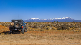
I wasn't here for the views, but I wasn't complaining, either.
Almost immediately, I took a wrong turn on the trail, but I caught myself within a few hundred feet and in no time I was headed the correct direction, into a Pinion Pine and Juniper forest, and then down into a canyon that had been hidden in the plateau just a few minutes before.

This first part of the trail was a bit bumpy, but nothing at all to worry about. And the ground was dry - nothing like the mud I'd encountered on my previous trip to the Owyhee Outback - something I'd been worried about due to a good amount of rain and snow that had fallen in the area a couple weeks before. Before long, I found myself at my first stop - fossils!

Initially I walked right by this petrified log without even noticing it. A little distance made it recognizable!

The end of the largest drumstick ever. I think. I mean, dinosaurs were essentially big chickens, right?
Thrilled with my discovery - or really, my ability to follow directions to someone else's discovery - I loaded myself back into the Tacoma and continued on. Some more twisting and turning and I found myself driving in a badlands of sorts, water having eroded the soft dirt in irregular patters, tight turns able to navigate some holes; others requiring me to slowly dip down and back up through them.

A common side-blotched lizard; my audience through the badlands.
The badlands extended a mile or two, and then I was climbing back up and out of them, now on the opposite side of the canyon I'd initially descended.

Up we go.

Looking back down, the badlands were more colorful from above.

More up.

I probably spent more time taking photos than actually climbing this hill.
Winding my way along the trail now, I was getting close to one of three obstacles on the trail that gave it a 7 (out of 10) rating by whoever knows how to rate trails. Known as Cave Canyon Hill, the terrain was definitely a bit rougher than I'd run into up until this point. I got out to walk this section of trail before continuing on.

A little rocky.

Nothing the Tacoma couldn't handle with ease.
After walking the first section, I found myself wondering what all the hubub was about. Sure, it was a little rocky, but just a little bit of line choice and 4-Lo made easy work of it. As a single truck, I figured it was only smart to walk the entire hill before starting up - so I did. It was the second section - which has eroded to a canyon, and is only going to get worse - that caused caravans of Jeeps before me to turn around. Some of the sections were narrow, requiring careful tire placement to avoid slipping into deep gullies, others spanned the gullies themselves, easier to navigate but perhaps more intimidating to look at.

A flexy section led to one that was only just wide enough for a - skinny - 1st gen Tacoma.

Nature's 4-post lift.
It wasn't the narrow or eroded sections that were the difficult parts here; rather it was the transitions between these that would provide adrenaline to drivers, so I took a careful look at the line I wanted to take through these transitions and then slowly navigated my way up without drama!
Having skipped breakfast, the top of this hill - a plateau really - was the perfect spot for an early lunch; a good view and plentiful camp sites in which to get off the trail in case someone else came along. Of course, no one did as I ate my Vietnamese chicken sandwich, chips, and apple with a view of the mountains.
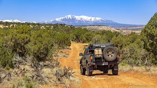
I had the whole place to myself.
My belly full, I packed everything back into the Tacoma and decided to do a quick once-over of the underside of the truck. I'd heard what I thought were some unusual creaks and vibrations at various points through the morning, and figured that I might as well verify that all of my shocks and suspension components were still bolted firmly to the truck. Or, more likely, that one of the bolts to the skid plate had loosened up again.

"Loosened."
If by loosened, one means "gone," then yep, it turns out that the two rear bolts securing the skid were definitely loosened. I considered pulling out the OSK to find some replacements, but decided I might as well wait on that until I got to somewhere paved - just to keep my clothes a little cleaner on day 1. Making a note to choose lines a little more carefully so as to not tax the compromised skid plate, I soon reached the far edge of the plateau and dropped off the other side.

Back down we go.
This trail, it turns out, was a series of ups and downs - terrain wise - and after dropping off one plateau, I soon found myself at the bottom of a canyon, at a wash that - at times - is still quite active. So active in fact that it's completely washed out the road, making for a big ledge that has to be climbed in order to extract oneself from said wash.

The climb up Deadman's Ledge. Requires good approach, departure, and break-over angles.
As with the first obstacle, the reputation of Deadman's Ledge was greater than the actual difficulty - at least in my opinion - and with no trouble at all plus a locked rear end, I made it up on the first go. I must say, I breathed a sigh of relief at this point - I'd heard quite a bit about this obstacle, including several videos that showed Jeeps being winched up, almost rolling over, etc. - and it had always been in the back of my mind that I might turn around when I reached this spot.
Instead, I continued on to Bradford Hill, the last difficult section of trail. This was a rocky, downhill, set of ledges, and I once again took a few minutes to plot my course before dropping down the near-vertical 15-foot section of trail.

Who needs skids?
And with that, I was done with the hard stuff. From here, I had only sights to look forward to - the first being some old Indian ruins built up into the cliff not far from the trail. Predictably, I got out to investigate, hopping from rock to rock, trying to get the best angle.
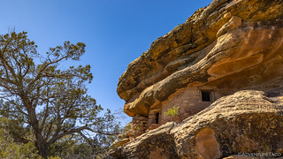
My first ruins of the trip!

Nestled into the landscape.

Careful chinking.

Time takes a toll.

Craftsmanship.

Pottery, even some with exterior artwork.
While not huge, this first ruin was one of the few cliff dwellings I've seen - most of what we saw on our previous trip being built on open ground - and so left me feeling energized as I continued my loop back towards Blanding. It was another several miles before I'd come to the old Dixie Number 1 and Bradford #7 uranium mines - the last attraction along this trail. Across another ravine, I first spotted the old ore chute clinging to the hillside.

Remnants.
A short spur led partway down my side of the ravine, and for the first of what would be several down-one-side-and-up-the-other hikes, I headed over to check them out. Turns out there were lots of short tunnels into the canyon wall, none of them extending more than about 100 feet.

Don't mind me, just holding up a moutain.
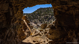
Nice view...too bad it's from a Uranium mine.
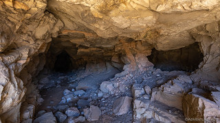
Twin tunnels.
And with that, it was some 15 miles of graded BLM roads back to Blanding, the drive easy and the views grand. The loop had taken me a couple hours longer than I'd planned, but I wasn't complaining at all. Well, except about those missing skid plate bolts.

There they are again!

Easy cruisin'.

The last turn before town.
In town, it was feeding time for the Tacoma - just a little snack, since it was still mostly full from the morning meal - and then off to an ACE Hardware parking lot to replace the skid plate bolts - in case I didn't have any in my kit.
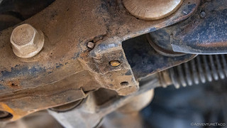
Uh oh.
So yeah, turns out I'd somehow sheared off the bolts rather than lost them, and my choice now was to extract them, remove the skid, or just run it as-is. In the end, I opted for the later, with regular inspections to ensure I didn't lose any additional bolts.
That decision made, I set out west along UT-95 towards the spot that'd befuddled us the last time we'd come this way: the ruins of cliff dwellings known as Lewis Lodge. The last time we'd visited, we'd hit snow around 6500', so this time I'd reached out to Randy - a fellow adventurer who's a bit more local - to ask what the snow situation might be like this year if I tried to access Lewis Lodge through Bears Ears National Monument.
His response, unfortunately, wasn't what I wanted to hear.

Bad news.
However, the suggestion to head up past Hotel Rock gave me some hope, and I figured that starting at 3:30pm would give me plenty of time to hike to Lewis Lodge after completing the seven mile drive. All I can say is... Famous. Last. Words.
On the highway, I threaded my way through Comb Ridge. I'd spend much of the remainder of the trip along this ridge, and I came to quite enjoy it.

A serious road cut.

Making my way up North Comb Wash.
Note: Visiting the Comb Wash area requires a pass. For more information, check out BLM Utah Cedar Mesa Permits and Passes Information.
Then, a mile or so up North Comb Wash, my turn off to Hotel Rock was right where I expected it to be. Almost immediately, I was glad I'd left my skid plate on. This road was nothing like I'd expected. So rocky! And ledgy!

Yes, there is a trail there.
There was - essentially - no dirt on this trail. It was simply a series of tire marks up through the slickrock. As such, it was difficult to stay on-trail, and I soon found myself following a route many others have taken, but that does not lead to Hotel Rock. Instead, I found myself bouncing my way to an overlook of Arch Canyon.

I was off route, but I couldn't really complain about this view.
Retracing my steps, I found the spot where I'd gone wrong, and continued on the correct way. If such a thing was possible, the road got rockier, the ledges got taller, and the trail got narrower along the side of the cliff. I had 3.5 miles of this trail before reaching Hotel Rock, and the first half mile took me nearly 45 minutes.
Finally - as I encountered a series of three near-vertical chutes that each individually reminded me of the wall on the Poughkeepsie Gulch - I gave up. Without a spotter or second truck to pull me out in case of disaster, this was just getting stupid. Lewis Lodge had beaten me again!
While I knew I couldn't complete a 14 mile roundtrip hike to Lewis Lodge at this point in the day - it was nearly 5:00pm by now - I figured that the 6 mile roundtrip to Hotel Rock was still within reach, as long as I brought a headlamp for the return trip. So, I made the decision to position the Tacoma for camp, right there in the middle of the trail - because seriously, no one was coming - with a nice view of Comb Ridge, and set out on foot.

Camp of defeat.
As I hiked up the road - which again, I was only able to follow based on rubber marks on the rock, and by constantly looking at my tablet to ensure I was on track - I made significantly better time on foot than I'd been making in the truck.

Hiking the middle of the "road." Seriously.
As I crested the ridge, the views were splendid, a few clouds having formed to my west, turning the oranges and reds of comb ridge into a deep, dark band across the landscape.

Looking north.
It was an hour or so - right around 6:00pm when I finally reached Hotel Rock. Rising up and standing alone on the top of the plateau, I could see where it got its name. My already fast pace quickened over the last half mile.
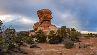
Portrait view.

Landscape view.
Even from half a mile away, I'd spotted the cliff dwellings. As I got closer, I could see that they were - at this level anyway - built into a recess that largely ran around the entire rock, creating a space some six feet tall and ten feet deep. Softer sandstone that had eroded away - most likely - leaving a perfectly sheltered spot to create hotel rooms.


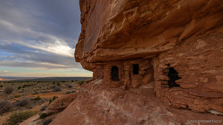
I spent some time just climbing around - and looking into - each of the rooms. Perhaps these were used for shelter, but their size and the uneven ground inside suggested to me that they were more likely for storage than habitation. As I did, the clouds continued to roll in, the sun streaking down as it could to illuminate the landscape.

Comb ridge color.
After completing my exploration of the obvious ruins, I could have just headed back to the truck - likely making it back just after sunset, but I found myself wondering if this was a two - or more - story, hotel? So, I wandered around the base until I - perhaps even a little surprised - found a route up, my curiosity now piqued!
Sure enough, a second level contained ruins as well, though significantly fewer in number and in much worse condition than the ones closer to the ground.

Petroglyphs!

Once tall walls, ready to reassemble.
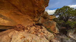
A stash of stone bricks, ready for building.
Making my way around the entire upper level, I eventually found a different way down, the sun just setting as I reached the bottom - a warm purple spilling across the sky.

If these were rooms, they had a great view.
Now with limited light, I started back down the trail toward the Tacoma. I surely hadn't made it to Lewis Lodge, but Hotel Rock was no slouch either - I'd thoroughly enjoyed my time there; even the hike, enjoyable. The cherry on top? - as I glanced west, an arch caught my eye!
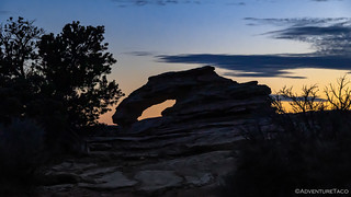
Uneven Arch.
Even with the sun below the horizon I was able to hike most of the way back without the use of my headlamp - enough twilight to see where I was headed. It was only dark the last half mile or so - a point at which I could see camp in the distance, the tent shining bright as a beacon on the side of the ridge.

Easy to see from a distance.
Back at camp, I made a quick dinner under the light of the canopy and spent a few minutes copying photos off the camera before yawning and deciding that an early night - after two nights with not enough sleep - was a reasonable course of action.
And so, camped here in the middle of the road, I brushed my teeth, grabbed a change of clothes, and climbed up the ladder. I still needed to figure out how I was going to adapt the trip given my inability to reach its main impetus, but that was going to have to wait for morning.

Stars up, lights (nearly) out.
Little did I know as I nodded to sleep - this wouldn't be my last attempt at Lewis Lodge. Not by a long shot.


Excellent photos!
Looks like a fun trip.....
Great stuff as always, I love the Utah trips. Looking forward to seeing if you headed down Arch Canyon.
Thanks Ben! Spoiler and teaser in one: Being so close, I wasn't going to miss Arch Canyon. But, it wasn't the highlight of the day. ?
Thank you again for leading my mind back to the desert trails and their beauty. You do a nice job of providing the visuals that illuminate the story so we'll. Can't wait for the next one!!???
Sure thing Thomas, I'm glad you were able to immerse yourself in it! Next one on Monday...at least, that's the plan. Hopefully I'll be able to wrap up the entire trip next week.