
We didn't stick around in Ten Sleep any longer than necessary - mostly for the same reason that we scurried from Atlantic City and South Pass the day before - people. I'm sure that all these places would be super fun to wander around mid-week, but on a warm summer weekend they were just a little too crowded for our liking.
It was on our way out of town that we realized why it was so crowded. Sure, the road we'd traveled into town may have been beautifully reminiscent of Utah, but it certainly hadn't warranted a quadrupling of the population. But as we headed into Ten Sleep Canyon, it was clear where the real attraction was.

We were so distracted by the towering walls of the canyon that we missed our turn off the highway!

Once we snapped out of our drooling daze at the canyon around us, we found a pull-out where we could turn around. But not before snapping some more pictures.
Back on the right track, we were soon winding up the eastern side of the canyon - either on the old highway or on an old rail grade. Whatever it was, it was unpaved but not at all uncrowded. There were vehicles everywhere, and we soon discovered why.

No matter how you climb up through Ten Sleep Canyon, the views are fantastic.

Of course, some climbs/views are harder/fantastic-er than others, I suppose.

Still had a long way to go.
Yep, the canyon walls had been discovered by the climbers, and the popularity of Ten Sleep was immediately apparent to us both. After a bit of glassing with the binoculars, we were back in the truck and on our way through a single gate, re-joining the highway for a moment before diving off onto dirt again, as we began our first big ascent into the Bighorn Mountains.

Looking back down towards Ten Sleep.

Gaining elevation quickly as we exited the canyon, the hillsides greened up, the juniper giving way to pine and fir.
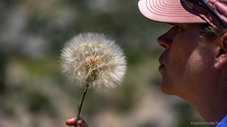
Make a gigantic wish.
Before we knew it, we'd climbed from 5200' to 9300' and found ourselves at our first dramatic overlook of the snowy Bighorns to our north and east. Getting out of the truck here was like stepping into a candy factory - the smell of the wildflowers, sweet in the air. Given our route, I knew we'd get even closer to the mountains, but we still hung around for a while, soaking in the visual and olfactory stimulation.

We'd spend the next two days in the Bighorns - a grand finale as it were!
A living bouquet.

So happy with the smells.
Eventually pulling ourselves away, I mentioned to @mrs.turbodb that - if possible - we should camp in a spot that Monte @Blackdawg had taken me a couple of times before - once on The De-Tour and again on The Re-Tour. We still had quite a bit of ground to cover in order to get there - and several stops in-between - but I hoped that with the long days, we could make it by sunset. She was game, and I'd say we made it a full quarter mile up the road before we just had to stop again.

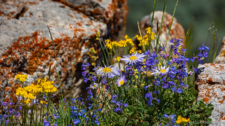
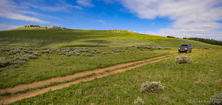
Into the high mountain meadows, purple rivers stretched through fields.

So. Many. Lupine.

Stands of trees broke up the purple hillsides, audible gasps and finger pointing sure to resume as we exited the narrow passages to new stunning vistas.
At this point, the route wound its way out of the mountains and down toward Hyattville. I'm not exactly sure why the BDR planners chose this path - rather than maintaining elevation in the Bighorns - but it would give us an opportunity to check out some rock art that I hoped @mrs.turbodb would appreciate, so down the mountain we dove.

A little hazy, but still - I don't think most people would attribute a view like this to Wyoming.
Unfortunately, our dive down the mountain turned into a bellyflop when we found ourselves behind a couple of Jeep Rubicons that had a top speed somewhere in the 4-7mph range. It's not that the roads were difficult or that the Jeeps were underbuilt. In fact, quite the contrary, they were motoring along on aired-down 35" tires and top-of-the-line suspension. Initially, I thought they might not be looking in their mirrors; then that perhaps they were simply looking for a place to let us by. But, after passing several large pullouts, it seemed something else was going on. Surely a couple short flashes of my bright-as-the-sun Diode Dynamics SS5s and a friendly toot of the horn would get them out of our way in a jiffy.
Nope.

It was painful to be stuck behind such capable vehicles.
Eventually - as in 20 minutes later - we finally came to a gate. As both Jeep drivers got out of their vehicles, it was immediately apparent that it was a couple - each in their own toy. With no way to communicate with each other on the trail, the wife hadn't wanted to be separated from her expedition leader, and he'd had no way to signal her to pull over behind him. Radios: they are important.
Hoping to make up time, but knowing that we had to stay ahead of the Jeeps, very little braking was used as gravity pulled us down the hill. It turns out we had nothing to worry about from a "catch up" perspective, as even with several stops for photos, we never even saw their dust trails in the distance.

It was amazing how varied the color of the dirt had been in this area; here, nearly white.

Just moments later, a deep red.
Nearing the bottom, we spotted an old homestead in the distance. At first, we were both convinced that it was still occupied - a bit of a relief in that we'd not be tempted to explore. But the closer we got, the more apparent it became that we would be looking around - for a few minutes anyway - as the homestead had been abandoned for a couple decades or so.

Homesteaders definitely had an eye for picking the picturesque spots.

The front house was an addition to the back, and clearly in better shape.

Left in a hurry? Thought they were coming back?
Whatever the reason the homesteaders had left, the proximity to the road and several open doors meant that rodents had gotten into the place, and it was now beyond repair; unfortunate, as it seemed like a pretty nice place in its time. And so, content to climb back into the air conditioned Tacoma, we soon found ourselves rolling into - and out of - Hyattville, on our way to Medicine Lodge.
Medicine Lodge has served as a gathering center for people for at least 8,000 years. Early people left behind a legacy of ancient petroglyphs (rock carvings) and pictographs (rock paintings). A 1971 archaeological investigation revealed details about a campsite at the confluence of the dry and running forks of Medicine Lodge Creek. Located at the base of a sandstone bluff, the campsite today has chokecherry, cottonwood, and willow trees and an abundance of game. It also is a state archaeological site administered by Wyoming's recreation department.
Historically, native people used it as a temporary campsite. Evidence they left behind includes glass trade beads, pottery fragments, projectile points, and food, including grass, seeds, wild fruit, and roots. Site use dates back 8.300 years. Archaeological research further indicates that the people using the area probably only lived until their early or mid-thirties. They prepared much of their food by grinding it with sandstone metates that left sandy grit in the food. Years of eating such a coarse diet eventually wore down their teeth, likely explaining their 35-year life expectancy.Roadside History of Wyoming

Happy man.

This combination petroglyph-pictograph reminded me of the sundials I've seen at other sites.

Fat family.

Horned lady.

Insect guy.

Native Americans weren't the only ones to make their mark on this wall, Burgess and Martin passed through here many times and left several axle-grease marks.
Having made it to Medicine Lodge, we were making good progress - we'd covered 57 miles since lunch - but were still some 50 dirt miles from camp, a five-mile spur off of the BDR route. It was 4:00pm and hot at our current 4,700-foot elevation; we hoped that camp in the Bighorns would bring cooler temperatures.
With that, we set off. It wasn't long before the 5,000-foot climb began, all of our elevation achieved over the course of 15 miles at a relatively consistent 10° incline. The weight of the Tacoma meant we were between second and third gear for most of that time, as the landscape alternated between trees and meadows. With each passing mile, the temps moderating. Pure bliss.

Dappled light filtering onto the roadway as we once again climb into the Bighorns.

At a second overlook of the highest peaks in the range, the Tacoma perched at the edge.

A river runs through it.

Out on the edge.

At Upper Medicine Lodge Lake, one of several we passed along the way.
This part of the BDR - and, really, everything that remained - was some of the most beautiful road we've traveled on any of the discovery routes that we've done. I suspected that would be the case, as I've spent a week or so in the Bighorns on other trips, but with the last of those being in 2019, I'd forgotten how special this range really is. The views go on and on, with ample variety of terrain to providing endless enjoyment for those passing through.

The mix of rock, trees, wildflowers, and meadows was mesmerizing.

Racing along ridgelines, the condition of the road varied, but we were able to keep relatively reasonable rates of travel.
In the end, we made great time through the Bighorn Mountains, reaching a road I remembered fondly as our "exit route" from both the De-Tour and Re-Tour years before. Climbing up though the Aspen, I glanced over at my dozing co-pilot, hoping that she'd find our camp site - now only 10 minutes away - as lovely as I remembered it.

The final climb, a single ridge between us and a relaxing hideaway for the next 12 hours.
Popping over the summit, the view before us opened up to a peaceful meadow, ███████ Creek meandering through the tall grass. It appeared - and would turn out to be the case - that we had the whole place to ourselves, as we made our way down to camp on the edge of the meadow.

The clouds were looking dramatic as we pulled into camp.

Pretty soon, we were set up in my favorite spot, the temperature much more pleasant than it'd been at lower elevations.
Unfortunately for us, the lush, spring green grass and plentiful water nearby meant that summer's first wave of mosquitoes were in full swing. We'd brought along our goofy-looking bug net jackets for just such a situation, and broke them out for the preparation and consumption of dinner.

Looking netty.
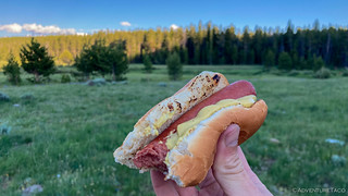
They may seem like a cop out, but hot dogs are always a treat when we do end up eating them!
Of course, to eat, we had to remove our hoods. Miraculously, at exactly the same time we sat down, the wind picked up and our mosquito problem became a non-issue. The wind would mean a bit noisier night in the tent, but if one thing is for certain - it is that wind is better than bugs.
The Following Morning...
It was, I think, the best night of sleep we got all trip. The wind died down just as we climbed into the tent, and with a calm breeze and temperatures in the high 40s °F, the camp site I'd been looking forward to showing off to @mrs.turbodb was delivering. The only drawback was that our position out in the meadow meant dew, and so the tent was a little damp when we woke up in the morning.

I always love when the colors smoothly morph across the sky before the sun comes up in the morning.
Knowing that we'd easily finish the route by the end of the day, we lazed around a bit on this - our final morning on the trail - before getting up around 7:30am.

I'd hoped that our two-hour delay in climbing down the ladder would completely dry the tent, but alas, some high clouds meant that it could have used another hour.

Wandering around camp, I followed the path of ███████ Creek for a while, enjoying the gurgle as it passed on by.

Even the trees were happy.

Headed back to camp to find my compatriot.
The wind that'd pushed the mosquitoes away the night before hadn't returned, so with netting over our torsos, we packed up the tent and got ready to go. Luckily - even though bits of the fly were still damp, I knew we'd have to deploy the tent one more time - on our way home - which would allow it to dry out.

Before leaving the area entirely, I showed off a second primo camp site to @mrs.turbodb, just across the meadow (and creek).
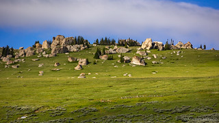
Climbing out of the valley, we once again found ourselves skirting along a broad ridge, this time working our way past Antelope Butte. We didn't notice as we approached, but as we skirted through the grass below the rocky outcropping, we suddenly noticed movement. Lots of movement. A herd of Elk more than 200 strong - by far the largest we've seen - covered the upper reaches of the butte like a swarm of bees.

As we approached, the grandeur of the butte itself is what caught our attention.

Then, our surroundings had us marveling at the morning.

Flowers for the lady.

Only as I was out picking my arrangement did @mrs.turbodb spot the Elk. And my, were there a lot of those guys!
Noticing that there was a road that climbed at least part way up Antelope Butte - and wondering if we could find a way closer to the herd - we worked our way up and around it became clear that we'd be in a different position, but not all that much closer to our ultimate goal.
Even though we didn't get any closer to the Elk, it was interesting to see the butte from another perspective. A much greener one.
And so, we retraced our tracks to the main route - now headed towards Woodchuck Pass - more high meadows, rocky granite outcroppings, and even a cow and baby moose grazing in the distance below. We hadn't been on the trail more than half-an-hour, and the day was already turning out to one of the best!
Retracing our detour to join the herd on the hill.

The clouds, light, and rock play so well together in the Bighorn Mountains.

Our second set of moose on this trip. And, a baby!

Past Bruce Mountain and through Woodchuck Pass.
We had only a single stop planned between Woodchuck Pass and the end of the stage at Burgess Junction - for a splash dam I've wandered by previously. It's not marked at all on the BDR route, but is marked by an information sign on the roadside, and I highly recommend checking it out for anyone else travelling the route.
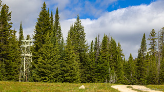
As usual, we got sidetracked before the splash dam, an unknown tower catching our attention. Perhaps an old weather station? Ham radio repeater?

What remains of the splash dam. The water was much lower here the last time I visited.
The structure before you is known as a "splash dam" (also referred to as "surge" or "flash" dams), part of an old transportation system for the movement of logs and railroad ties from the forest to sawmills in the valley. The process began by dragging or rolling logs into the river bed while water was being stored behind the dam. When conditions were right, the gate was opened the logs "flushed" down to small ponds near a flume entrance, The flume, a raised wooden V-shaped structure, then carried the ties, with the help of water, to processing facilities near Dayton, Wyoming. Ties moving down the flume were reported to reach speeds of nearly 80 miles per hour. Parts of the flume were built as early as 1892 by the Starbird and Hall Logging Company. Construction of this "splash dam" occurred around 1905.
As we admired the splash dam, a caravan of semi-trucks loaded with cattle came rumbling up the main road. Five of them, each with a dozen or more cows mooing and pooing away, we counted ourselves lucky that we'd completed our stay in ███████ Creek. I've been there before when the cattle have been grazing, and it was a tense morning as one trapped me in my tent.

A whole new understanding of "cattle drive."

A standoff at dawn, 2019.
It was nearly 11:00am by the time we started the final stretch - some 15 miles - to Burgess Junction. Our speed was a quarter of what it had been on every other morning of the trip, a testament to our surroundings. Even this last little bit would take us longer than normal, as we enjoyed one of the bumpier sections of trail, and of course, views to go along with it.

There's nothing on the route that's even moderately complex for a 4-wheeled vehicle; this was about as extreme as it got.

The views - on the other hand - were second to none.

Only a lodge - and this warning sign - marked the beginning of the end of the WYBDR.
As we pulled out of Burgess Junction, we weren't quite sure what was in store for the final leg of our journey. Upon reaching the border with Montana, would we go north or return south? Would this final segment - as with so many other BDRs - be a weak point full of pavement or as splendid as the last? And, perhaps most importantly, since we were getting hungry - where were we going to eat lunch?
The Whole Story


Love Backcountry Discovery Routes? Check out
BDRs we've run
to find your favorite.


")
")


")
As always, I thoroughly enjoyed your reporting, impressions, historical facts and photography. Looking forward to your next journey.
Beautiful scenery and cloud formations. The wildflowers were a beautiful sight and I am sure a lovely smell. I am surprised at how green it still is, did you get any rain on this trip? One of my secretaries was from Ten Sleep a cowgirl through and through.
When the aircraft boneyard was still in Greybull I got to wander all around the planes and explore. They built retardant planes here for shipment all over the country. We built a chemical plant in Basin Wyoming many years ago and I flew into Greybull many times.
My flight in my 182 from Nampa, Idaho to Greybull took me over some spectacular country and between the peaks of the Teton mountain range.
Thanks for sharing your trip Dan, brings back many great memories!
Thanks Kenny! I loved the clouds as well - it's always no nice to get the puffy white ones! As far as rain - funny you should ask. We got about 3 minutes of rain at 11:00ppm as we were camped in the meadow on this leg of the trip, but it was easily dry by the next morning, and no other rain to speak of the entire time!
And boy, every time you pop in and tell a story, I find your life more and more interesting; I hope that we're able to cross paths one day - likely in the Owyhee area - and have a good chat. That, and/or you should write a book. I'd love to read it!
Thanks Dan,
I am going for a ride tomorrow around Hardtrigger in the Owyhees to check out the suspension settings on my RZR. Last time out it was way too stiff and rough riding. I lowered the tire pressure (8 ply tires) down to 7 psi and ran the retaining ring up on the rear shocks by 2". I also installed a particle separator so no more changing out air cleaners.
I am sure we will run into each other one day if nothing else but to have breakfast or lunch somewhere. Keep exploring, there are lots of places and things to see. I also spent a year in 1967 in Germany in the Army and had a license to drive everything from jeeps to tanks so I was able to travel a lot of Europe plus I had an aunt and uncle who lived in the town I was stationed in and my great grandma lived about 50 miles away.
I am truly blessed to have been able to see so many places and even better met so many wonderful folks along the way. My travels mainly took me to small towns and villages not many tourist towns.
Not sure if you're familiar with those green chest. As a Jump Team Squad Leader Combat Medic, I was responsible for two identical sets of 15 divided between two HMMWV pickups. After the fact, awesome experiences with those chest. Each set of 15 chest along with a general purpose tent small, litters, a small generator, etc. served as a rapid deployment Battalion Aid Station we leaped frogged as the FEBA (Forward Edge of the Battle Area) moved, mostly traveling by dead reckoning as the crow flies, no GPS then (or roads or trails). We never had any love for those chest but in some 4-5 years of tossing them around I do not recall ever replacing any. Good choice for your storage. Stay safe.
Wow, thanks for the background on the chests! They are super awesome, since - as you know - they are aluminum and so relatively light but super durable, stack well, and have a much more "rectangular" shape than a lot of the wedge-shaped totes these days.
I got three of them - 1 small and 2 medium about 5 years ago from a surplus place (in Montana). I've been looking for more ever since.
I heard from a surplus place in CA that some guys bought a lot of them for (Aluminum) scrap, but ran into issues at the recycler b/c of the steel clasps. Ended up not making much money b/c they had to manually remove all the clasps ?.
The biggest bummer though is that they were all scraped, so now it's hard to find them!
The large size (which is like 18" deep I think? was for med kits, I've heard. Is that correct?
I recall two sizes, the ones you have on the ground, which I used, and a bigger one, which the treatment platoon (10 bed hospital) used as they had more equipment, and also a duplicate to leap frog a 10 bed hospital. Imagine that! And mostly in the dark of night (in the snow and uphill both ways, but I digress???). The treatment platoon while less nimble than my aid station, nimble enough. Not only did we drive from point A to B, but all of us and the equipment could be airdropped or sling loaded to point B too, including the vehicles. Thus, the chest got lots of abuse. Nonetheless, the bigger ones were similar to these two you have except they latched onto each other and not the cap, and one of the halves had a divider between them. And you had to pay attention how they were being opened. Otherwise, if the one without the divider was on top EVERYTHING fell out when you opened it. As to being light, yes, except the ones with IV fluid in them. ? Because they were duplicates, one had black numbers with a red background and the other set the opposite. And every number was the same in the other set. I say that because we all knew what chest had the IV fluids, which was heavy, and which one had all the 4x4 dressing, which was light. Again, thanks for sharing. While war is never good, there are some AWESOME memories within too.