

It'd been four months since I'd last attempted to top Mt. Tom. Originally, I'd only wanted to reach the Tungstar Mine from the Pine Creek side - a route originally used by the miners - so I could check out the still-standing towers of the old aerial tramway that I'd seen thousands of feet below the mine workings when I visited the Tungstar from the Horton Lakes side a few years earlier.
I don't exactly recall how I discovered that Matt @theesotericone was also trying to follow the old tram line, but once I did, we quickly worked out a mutually agreeable time to give it a shot. Then, a week before we were to make the climb, I got a text from Matt along the lines of, "What happened to you? Hope you're OK."
Now, Matt is a prolific hiker of the Sierra, and thinking it was the day that we'd agreed to meet, he showed up at the trailhead, didn't find me, and proceeded to summit Mt. Tom. Solo!
It didn't take long for us to sort through the misunderstanding, and at 5:00am exactly one week later, we were both at the trailhead. Matt had proven it could be done, and I was about to prove that he was significantly more badass than I was. Because together, we didn't make it.
The problem for me - since I feel compelled to make excuses - was the snow. I didn't have the right equipment to safely navigate the plentiful patches of icy white, and with a good portion of the route being some of the steepest either of us had ever hiked, it wasn't a recipe for success. We turned around at approximately 11,300 feet, a couple hundred feet below the mine, and nearly 2,200 feet below the summit.
Ultimately, I was thrilled to have hiked with Matt - I always love meeting like-minded folks - but super bummed, especially now knowing that it was possible, to have failed at my attempt at the summit. Since then, I've been itching to get back, knowing that it'd have to be in the fall - when there'd be less snow - and probably when I drove the Tacoma south for the winter. And that's how I found myself at the same trailhead - in early October - at 4:30am.
It was not light. Donning my headlamp and grabbing the hiking poles that Matt had introduced me to on my first attempt, I took off up the Gable Lakes trail under the light of a nearly full moon. It was beautiful.

For the first two miles - and 1,500 vertical feet - the trail, primarily used to access Gable Lakes, was in great shape. But, even before the sun had crested the horizon, I'd left the good trail behind. Following a faint old foot path, I pushed across Gable Creek to begin stage two of the trail.

Already I could tell - or at least, I hoped - that I stood a better chance at making it to the top; the flow in Gable Creek was significantly lower than it'd been in late spring, when we'd been forced to remove our shoes and wade through knee-deep snowmelt.
This second stage of the route - which climbs from approximately 8,600 feet to 9,700 feet is utterly fantastic. Like many old mining trails, this one is barely perceptible in places as it climbs through seemingly impossible terrain. Switching back and forth, it expertly weaves its way through tortured trees, along harrowing headwalls, and between the aerial tram towers that originally piqued my interest in the first place.


Even following the old miner's trail - which was significantly easier than going "straight up" - this section of trail was not easy, but it was significantly easier than what was to come next. This third stage of the route was one that'd succumbed to a hundred years of scree-slides and avalanches, rendering it impossible to see on satellite. As such, Matt and I had made up a route - following a ridge around a deep chute - on our first visit, before regaining the trail some 1,000 feet higher.
Today, I was going to try a different way. I'd done a bit of research in the preceding months, and learned that the old trail dropped down into the chute, then switch-backed up a scree field to a saddle, where there was evidence of an old camp that once provided shelter for those working a couple thousand feet higher, at the mine.
I had no idea if it'd be possible today, but I had to give it a try.


It took me nearly 90 minutes to complete this segment of the climb and while I'm not sure it was any faster or easier than our previous route, I was thrilled as I reached the old mine camp at the saddle, since it felt great to follow in the footsteps of the miners, and I knew that the trail was visible again on the ground for much of the fourth stage of the climb.


Plus, with the saddle sitting right around 10,450 feet in elevation, this is where the views really started to get good.


Somehow, every section of trail seemed to get steeper and steeper, my body covered in sweat even though I wasn't yet in the sun. And so, it was already 9:00am by the time I'd climbed another couple hundred feet to the site of an old workshop and the elaborate upper anchorage of the old aerial tram.


Savoring every second I wasn't pushing higher, I knew I needed to keep moving. Even though I'd begun under the cover of darkness, I knew that getting back before it was dark again was going to take all the effort I could muster. I wasn't yet to the spot - still 400 feet higher - where Matt and I had turned around, somewhere around 11,300 feet. I pushed on. I pushed up.
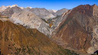

Eventually, I reached the highest still-standing towers of the aerial tramway. There are four towers in this grouping, each identical to the other, as they transported heavy buckets of ore to the mill below.

Previously, at these last four towers, Matt and I had deviated from the old miner's trail. I don't recall exactly why - probably either because we lost the trail or because the trail dropped into a chute filled with ice - but we'd continued up the ridge, past two collapsed towers, to the spot where we ultimately turned around.
I did remember how miserable that up-the-ridge segment was though, so I'd done a little more research in the intervening months. Though several sections of the trail were no longer evident on the ever-eroding face of the mountain, I'd determined where I needed to go in order to pick it up again, where it was still visible as a series of switchbacks that led the final few hundred vertical feet to the Tungstar Mine.
I can't tell you how happy I was - after setting out through a steep, loose-scree-filled chute - to find the trail again 37 minutes later. Well, except for all the up I could still see above me. At least though, I knew that from here I could make it to the mine.


It was 11:19am when I reached the mine, nearly seven hours after I'd started my endless climb. I'd covered 4.4 miles and 4,400 feet of elevation. It was time for lunch - and a few photos - before continuing an even steeper section of trail to the summit.


If the 4,400 feet of elevation in the first 4.4 miles had seemed difficult, I had another thing coming. From the mine, the trail to the summit covered 0.61 miles and gained 1,642 feet according to my pocket mainframe. A standard staircase rising the same height would have been a similar distance - somewhere around 0.58 miles long - though significantly easier since I wouldn't have had to navigate loose scree and sliding rocks; each of which surely resulted in sliding back one step for every two I attempted.
To put it another way, it was steep. Nearly three times as steep as the trail I'd already endured.


By this point, I was moving as quickly as I could - I knew I was going to have trouble getting to the top early enough to make it back down by sunset - and yet I felt like I was moving so slowly. Every couple dozen steps I had to stop - both to rest and to visually pick out the path that I thought would most successfully lead me higher.

Eventually, a respite on the ridge. Here, I got my first glimpses to the southeast. As those to the west, they were spectacular. Far below, emerald lakes and the trail that'd first led me to the Tungstar.


I pushed on. Utterly spent, I couldn't understand how the trail kept getting steeper. By this point, I was nearly scrambling on all fours to navigate the boulders, hoping that each was firmly enough cemented to the mountain that it would support my weight. Mostly, they did, and I'd brought no change of undies for when they did not.
But eventually, I was rewarded. Miraculously, the ground stopped going up. I’d like to say I wept with joy. What actually happened is I sat on a rock, wheezed like a malfunctioning accordion, and wondered what made crazy hikes like this seem like a good idea at the trailhead.
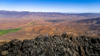


It was right around 2:00pm when I made it to the top, and only about ten minutes later when I snapped the last couple of photos and started picking my way back down. I had just under five hours of daylight, and it'd taken me nine hours to hike up. Down would definitely - hopefully - be faster, but whether it'd be twice as fast on terrain like this was not something I was willing to bet on.


In fact, I did make reasonably good time down; it helped that I was no longer fighting gravity, at least not in the same way. Now I was fighting for balance, as each step threatened to slide my feet out from under me. And then I heard a familiar roar.

Just below the mine, I decided to abandon the trail - at the same gnarly section that was no longer visible on the way up - in hopes that I could more easily traverse a large bowl to the old miner's camp. Digging the sides of my feet into the scree, I rode the rocks as they slid down the hill, hoping that I had enough elevation between myself and a saddle where I knew I could pick up the trail once again.
I did. Just barely.


As quickly as I could I picked my way through the rocks. The mountains I'd been above were soon, once again, above me. The sun, having started on the eastern horizon, was quickly approaching its terminus in the west.


I arrived back at the Tacoma twenty minutes after the last rays had left the skies. It would be dark by the time I traveled about a mile to the place where I'd planned to camp.
There, under the illumination of my headlamp, I'd set up the tent and contemplate skipping dinner altogether. I was starving, and yet, not hungry at all. Ultimately, though, the draw of taco-rritoes and guacamole was enough to coax out the kitchen as I counted the seconds before I was off my feet with my eyes closed.
I snapped one final shot as I brushed my teeth. It'd been a long day - that both started and ended under the cover of darkness - but worth it. I'd finally gotten to the top of Tom, and I'd done it the hard way.

The Whole Story


Discussion
No comments yet.