
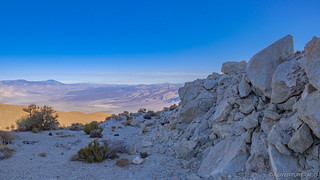
Unlike most nights, where the temps seem to drop to their lowest point just before sunrise, our night high in ███████████████████████████████████████ the Inyo Mountains turned out to be just the opposite. At some point, I was so warm that I even removed one of the comforters in order to maintain a reasonably-cozy-and-not-all-sweaty body temp. Even @mrs.turbodb commented on it in the morning, as we enjoyed our breakfast.
That of course was after I'd gotten out of bed in order to capture what might have been an amazing sunrise. See, as we'd arrived the previous evening, one of the things we'd noticed was that there was quite a bit of high-level smoke to our west. With a westerly wind, I figured we'd either reap the benefits of that smoke - with some spectacular color - or we'd end up with nothing more than a hazy mess. If the end, I think we got a bit of both.
The light on the horizon started oranger than we'd seen previous mornings - likely because this was the first time we had enough elevation to see closer to the horizon. The bright orange lasted only minutes, the smoke becoming more hazy as the sun neared the horizon.


I probably scurried around camp - literally jogging from spot to spot in order to try and capture the grandeur - for a good 90 minutes before finally deciding that there was really no way I was going to be able to be in all places at once, and I'd just have to find my way back in the future so I could spend a few more days here. With @mrs.turbodb now out of bed and breakfast behind us, it was time to get on with our day. We only had about half the day to spend here in the wilderness - the other half to be spent making our way north towards home.
And here - once again - I should mention that I'll be doing this out-of-order and with a bit of obfuscation and/or redaction of certain places. If you know where they are, please do your best to keep them special as well!
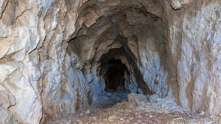
Luckily for us, our first stop was reasonably nearby - the ███████████████ Mine. This was a historic copper mine, responsible for more than two thirds of all the copper to come out of Saline Valley. Mined as an open cut, the most striking thing about this mine to me was the structure of the quartz crystals that are everywhere on the site. More than trillions of little crystals are imperceptible at first, and only on closer inspection does one notice the amazing geology.

As much as we'd have loved to stay to take in the views, we knew that there were other places to spend time before we hit the highway, and we pulled ourselves away towards our next destination. It's here that I'd be remiss however, if I failed to mention another really exciting experience that we'd had the last several days. In fact, it was one that I wasn't sure would be in the cards this time due to the unfortunate crash of a Navy F-18 at Father Crowley Point back in July. But - and I don't know if this has always been the Star Wars route, or if it's a new route for the planes - our time in Saline Valley was peppered with low-level fly-bys, several of the jets performing rolls as they passed overhead.
Could they see us - a lone vehicle with a dust trail as we drove our way around? - perhaps. But we could definitely see - and hear - them!

Surely, all of the folks at the Saline Valley Warm Springs enjoyed it as well. That place was hopping as we drove by - something that I think surprised @mrs.turbodb a little bit, given it's remoteness - and while we'd planned to stay there one night, in the end we were much happier with our private little spot by the Salt Tram - away from the chaotic parties that were surely raging below. A few minutes exploring the upper springs, and a quick stop at the bat sign, were the only time we allotted to what is - by far - the most popular place in Saline Valley.


Our next couple of mines were not quite on our way to the final destination of our trip - the mining ghost town of Cerro Gordo - but they were close enough. The █████████ Mine - which worked primarily silver - and ████████████████ Mine - which pulled garnets and several other semi-precious stones - were both located in the ████████████ near Lee Flat. We visited the silver mine first, working out way up to a small opening in the hillside. Don't let this opening fool you - if pressed, I'd say it was much smaller than the original opening, erosion of the surrounding area slowly working to cover this entrance. A few feet inside the mountain, both the the shaft height and width increased dramatically, large enough for several miners to work comfortably side by side.

We were in no way going inside this mine however - the loose dirt and rock, indicators to us that we'd be safer out here in the open! As it turns out, this mine was reasonably near another attraction, and there were a few other explorers already set up there when we were at the █████████ Mine, so we didn't hang out here long.

Instead, we headed over to the nearby ████████████████ garnet mine to see if we could find what we had heard was a profusion of garnet strewn about on the ground. This was especially interesting to @mrs.turbodb who'd also wanted to search for garnets on our trip to Indian Hot Springs in Idaho earlier in the year. There, we hadn't had time to do much poking around, but this time we figured it would be significantly easier, and so - why not?
Almost immediately, we discovered something else. In addition to garnets, this mine was apparently rich - at least, as far as we could tell - with turquoise. In fact, while we searched several tailings piles for garnets and never found any, there was no shortage of the bluish-green gem embedded in the surrounding rock. It quite literally, littered the ground!

Here too there were mine shafts - the largest of which seemed to be bored into reasonably solid rock. That fact, and my hope that perhaps we'd find a garnet inside, propelled not only me - but also @mrs.turbodb - forward twenty feet or so into the shaft.
...which is when we noticed this little guy on the ceiling. Now, for anyone familiar with my stories - you may recall that it was only a couple months ago that I found a bat under my mattress when I was putting away the tent one morning. The discovery was enough to send @mrs.turbodb back the way she'd come, and I spent a few minutes trying to get a photo before making my way out as well. Garnet-less! (Which was just fine - it's not like they'd be coming home with us anyway, though it would have been nice to take home a picture.)

With that, our exploration of the mine was complete - at least for this trip - and we climbed back in the truck and pointed ourselves west; our destination was Cerro Gordo. Located near the southern crest of the Inyo Mountains, this mining town founded by Mexicans in 1863 was unlike many in the Death Valley area. Where most mines were all work and no pay - disappointing generations of miners - Cerro Gordo was not only successful - it was the most successful. In fact, Hiking Western Death Valley retells a story of just how much silver was pulled out of this area:
Concentration of the ore by on-site smelting was a major part of Cerro Gordo's activities. The silver-lead bullion was cast into 80- to 90-pound ingots and freighted to markets my mule teams, beginning in 1868. For three years, renowned freighter Remi Nadeau hauled the huge production along the Bullion Trail to San Pedro. Everything was going fine until the freight contract was up for renewal in 1871. Nadeau refused to reduce his rates, and a different company was hired. This new company was unable to keep up with the smelters, and by early 1873, 30,000 silver ingots had been stockpiled at the nearby town of Swansea. Employees of the mine used these ingots to erect temporary shelters. [Yes, houses built of silver bricks!] Needless to say, the Cerro Gordo mine owners eventually contacted Nadeau and accepted his terms - his 80, 14-22 mule wagon teams, the only way to get the silver to Los Angeles and San Francisco in a timely fashion. In all, over $17 million was pulled out of the area (over $364.5 million in 2019 dollars).
As we made our way toward this historic town, Cerro Gordo peak rose in front of us - a striking view in the morning sun.

The drive to Cerro Gordo was a fun one. While not at all difficult or challenging, it was rougher - in a good way - than most of the other roads we'd been on, providing some terrain interest as we climbed to the saddle at 8,000-feet. And then, as we crested the saddle - even before we could see the town itself - we got our first peak at Owens Valley, and the Sierras rising up out of the other side.

We were mere feet from the town at this point, and as rounded the corner, it all opened up in front of us. Nestled into the folds of the mountain, Cerro Gordo was smaller than I'd envisioned. I can't pinpoint why, but for some reason I'd envisioned it with several checkerboard streets - a few blocks of buildings at least. Instead, there were a handful of very well maintained structures, and of course the entire place was surrounded by mining remnants in various states of disrepair.


As we stood looking around, Robert - the caretaker for the last 30+ years - rolled up on his ATV and we all introduced ourselves. Let me tell you this - the highlight of our time in Cerro Gordo was the 15 minutes that we spent talking there in the center of town. Robert was full of stories - both past and present - and his delivery of those stories, and obvious love for the town were awesome. I encourage anyone who visits to respectfully introduce themselves - assuming he's got the time to chat - and to ask him a little bit about the history of the place, and what notable things he experienced on the previous weekend!
One of the things I inquired about was whether he knew what the new owners had in store for the town. See, Cerro Gordo was sold in July 2018 to a group of investors, and many interested in the history of the Death Valley area have been wondering what's going to come of this historic ghost town. This got Robert on a roll, as he related to us how "the kids" who acquired the town were "city slickers who don't understand how things work around here."  Of course, I'm sure he's right, and to me, the idea of opening up a bed and breakfast, along with a night-time saloon sounds a bit crazy - I mean, it'd be neat, but seems too far away from everything to be a smashing success. Hey, at least they only paid $1.4- to $1.7-millon for the place.
At any rate, we eventually parted ways with Robert - he going off to continue stockpiling the 5 cords of wood he'd need to heat his cabin for the winter, us to snap a few final photos and then leave him in peace as we headed west - down out of the Inyo's and into Owens Valley.

It was at this point that I figured we were pretty much done with the highlights of the town, but Cerro Gordo had one more surprise in store as we rolled out of town - the view of the Owens Valley!


We enjoyed the view for the entire 20 minute trip out of the mountains, the Sierras looming larger and larger as our elevation dropped, and our distance neared. Along the way, we passed numerous ruins of mining equipment - relics of bygone days, perhaps something to explore on a future trip to the region. And then, in front of us - pavement. It was the first we'd seen in four days, and it was with mixed emotions that we pulled out the tools to air up our tires.
Ten minutes later, we accelerated onto the pavement of CA-136 on our way to US-395 which would take us much of the way home. We didn't make it 15 miles before we were stopped again - this time in the middle of the road. There, in front of us was Mt. Whitney. At 14,505 feet tall, it's the tallest peak in California, and a stark contrast to the lowest point - Badwater Basin, Death Valley (at 282 feet below sea level). More amazing is that the two are less than 90 miles apart as the crow flies!

As we got underway again - this time for good - @mrs.turbodb and I marveled at the just how fun this trip had been. Not all of it had gone to plan, but by in large we'd seen everything that we'd hoped to see - and more. It had, as always, been a bit more packed than it might have been if we lived closer - but still, we were both left wanting more. We would be back for sure.
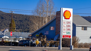
And hopefully when we were, the gas prices would be a little cheaper. I mean sheesh, aren't they supposed to go down in the winter months?!
The rest of the trip home was uneventful - which is a really good thing to say about a 1,000 mile, 20-ish hour drive! We made a few stops here and there, none of them worth talking about save two - Erick Schatt's Bakery in Bishop (which made @mrs.turbodb very happy), and Mono Lake. Exiting Death Valley to the west, we took a different route home than we've taken on all our previous trips, and as we passed this historic lake, we couldn't help but jump out to take a look at the Tufa formations protruding from the water's surface.


It was yet another highlight to an already great trip. More than that, it was another place to add to our ever-growing bucket list of places to go explore!
The Whole Story
![In Search of Overlooks - A Fall Trip to Western Death Valley [P1]](https://live.staticflickr.com/65535/49072602511_82aa16d541_h.jpg)
![Old Roads and Star Trails - In Search of Overlooks [2]](https://live.staticflickr.com/65535/49082756533_26e5373a5b_h.jpg)


")
")
")
")
")
")
")
")
")
")


")

")
")
")
Nice job of describing a great trip. Loved the "blackouts", of course. Re-lived some of my adventures there as you described yours. UJ
FYI - I have given up on Schatt's now that I have discovered Great Basin Bakery. I recommend going there next time you're in the area.
https://goo.gl/maps/HxJgLc532RHXcQ9q7
Might have to hit both of them! ? ?
When you went from warm springs up to Cerro Gordo did you come in from the east? I see the road off the ████████████████████████ but the only reports my google foo found was from 8 years ago. Going to DV in march and this is the route I wanna leave to get to 395. We’re going to hbe ghost town either way.
A great trip report again.
Hey Erik, Glad you enjoyed the trip report(s)! We did come into Cerro Gordo from the east (it is accessible from both the east and west) but as I noted in various parts of this particular trip report, this one is out of order so that some of the special places in it can be protected from my giving specific locations. My recommendation would be to spend some time with satellite imagery in order to figure out your route in/out of Cerro Gordo. I will say - even if you go up/down from 395, it's certainly worth seeing once!