
Having thoroughly enjoyed my time at Cedar Point, I figured it'd take me about an hour to make my way north, up the Moki Dugway, and to my next destination along Johns Canyon; this time the West Fork. But, as had been the case earlier in the day, events conspired to distract me as I pulled up behind another stopped truck in the middle of UT-261.
At first I wasn't sure what was going on. Then, I was fumbling to get my zoom lens fitted to the camera.


I thought for sure that it'd only be a matter of minutes before this cowboy had his target in ropes, but after shooting a few hundred shots over the course of 15 minutes, I realized that it had to be a little nerve racking for both him and his skittery horse. Even if he had the job done in an hour, that'd be about a week faster than I'd have been able to do it. Plus, it probably didn't help to have an audience, so I moved on.


As I summited the series of switchbacks, I realized that I always seem to end up at the Moki as afternoon is turning to evening. I'll have to change that someday to see what it looks like in the morning. For now, I covered the last few miles of pavement - then a few more on dirt - before finding myself all alone in the middle of nowhere, a perfect camp site at the tip of the West Fork of Johns Canyon.
Note: Visiting Johns Canyon (and Cedar Mesa in general) requires a pass. For more information, check out BLM Utah Cedar Mesa Permits and Passes Information.


Nearing 6:00pm, and with sunset a little less than two hours away, it was decision time - head out for a five-mile roundtrip through the West Fork, or call it an evening and enjoy the evening light playing across the land.
Obviously - as someone with explorers' disease - there was no real choice. I grabbed the camera, a bit of water, my inReach, and a headlamp - since I knew there was a good chance of returning in the dark - and dove off the side of the canyon.
At least, it felt like diving off - the trail was pretty steep - as I followed the cairns that would lead me along the loop I hoped to accomplish.


After dropping a little more than 300- of the 550-feet between the trailhead and the apex of my loop, the remaining 250 feet would come as I wound my way along the sandstone bottom of the canyon, enjoying the steps as I gazed upwards, my eyes peeled for the ruins I hoped to find.


Not long after spotting the eroding wall to my east, I headed west. While this might seem unintuitive, I had it on good authority that there were a few ruins - on a couple of different levels - 200 feet above me near the western rim of the canyon. I couldn't see them, and it was nearing sunset, but hey, it's just climbing nearly vertical walls and walking along narrow ledges, right? 


When visiting rock art and ruin sites, be respectful.
This is most easily done by following the Leave No Trace principles; leaving the place exactly as you found it and taking with you only photographs and memories. In case that is not clear enough for some reason, here are examples of respectful behaviors:
With relatively little to offer, I didn't spend much time at the lower level, instead beginning my search for a way to access the upper level of these ruins. Eventually - a few hundred feet away - I found the ladder.


Happy to have found the first major ruin site, I retraced my steps to the canyon floor just as the last of the sunlight inched its way up the last few feet of canyon wall above me. Without a doubt, I was not on borrowed time as far as light was concerned.
The light situation didn't bother me all that much. My prior research suggested that the second set of ruins was near the top of the canyon rim and - essentially, given that I was making a large loop - on my way back to camp. Still, it's better to have a bit of light for photos, so I hoped I'd find the ruins reasonably quicky.
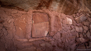
To my surprise, I hiked for only a few minutes before spotting a granary much lower on the canyon wall than I was expecting. Turns out, this wasn't the second ruin site I was looking for but rather a third site that I'd had no idea existed!


After spending a few minutes at this unexpected discovery, I continued to climb toward the mouth of the tributary canyon in which I now found myself, skirting steep dry falls and working my way along sandstone ledges - an activity I'd find myself repeating over and over in the coming days. Eventually reaching the uppermost bench, I doubled back towards the main canyon in search of the ruins.

It wasn't long before I came to a series of granaries - ten or so in all - that lined this level of the canyon. Clearly less visited than the first set, an audible "wow" may have escaped my mouth when I encountered the first one.


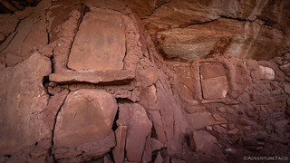


With dwindling light - and a belly that was beginning to complain about the amount of time that'd passed since lunch - I continued around the bench, hoping to find the very first wall ruin I'd spotted from the wash nearly an hour earlier. Unfortunately, I now found myself above the wall, with no short path to the bench below.

With that, I picked up the pace - as much as one could, given the 16 miles I'd hiked on only five hours of sleep - as I pointed myself towards camp. I was tired, hungry, and 100% ready to do it again, right after a big dinner and ten hours of sleep.

It'd been a fantastic first day in Cedar Mesa, and I was even more excited for what I had planned in the days to come. In the end it was so much more hiking than I'd envisioned, and so much more enjoyable than I ever imagined...


Really enjoying your report on this area. Two years ago I camped on Muley's Point, after ascending the Moki Dugway. Also camped for two days in the Valley of the Gods. Hoping to return, on an extended trip, later this year. I'll be sure to check out Johns Canyon.
Thanks Lapsley! I really debated driving it to the top of Muley Point, but I just didn’t have enough time since I wanted to get the last hike in. Next time!
Amazing photographs of the horse and rider. You've really outdone yourself with this series.
Thanks! Was pretty cool to see him out on the range, and no surprise that he was stopping traffic. Hope you enjoy the rest of the trip, the next part is now posted here:
https://adventuretaco.com/road-canyon-three-ways-rr-3/
Your puzzlement at the location of the survey marker you found stems from your
imperfect knowledge of such markers. There are numerous types, but basically you
could say that one type is at an arbitrary location, generally one with a good
view in many directions or at the top of a peak. These are often used for triangulation.
The other type marks a man-established location, e.g. a county or state boundary, a
standard meridian, or the like.
The first type generally will have a small triangle in the center, and in the center of
the triangle a centerpunch. This is where the surveyer will place his instrument above
monument and have the point of his plumb bob just above the centerpunch, thus making
it possible to duplicate the location used by the original surveyor exactly.
The other type is what you have illustrated here. Ever since George Washington was a
surveyer, our lands have been divided into Sections (one square mile), and Sections
gathered into 6x6 mile blocks called Townships. In a Township, the sections are
numbered thus:
06 05 04 03 02 01
07 08 09 10 11 12
18 17 16 15 14 13
19 20 21 22 23 24
30 29 28 27 26 25
31 32 33 34 35 36
Your marker shows the location of the SE corner of Sec. 31 and the adjoining SW corner of Sec. 32, of Township 39S, Range 18E. Below the horizontal line is "T40S, R18E" because that is the next Township to the south.
If your system allowed sending images, I could have made this clearer, perhaps.
Wow! Super cool, thanks for the lesson on survey markers - I’ve always known that there was more to them than I understood,, but I never really had the time to figure them out.
Your explanation was great and made total sense, by the way. Please, if you find other bits of my stories that you can educate me on as well, don’t hesitate to do so!
Cheers!
I wonder when these were built, how long did it take them to build, and how long did they use them. One of these days, I will stand where you did to ponder those questions. Till then, continue the trails!!
Hey Bill,
In this area, archeologists have done a bunch of research into the time periods that occupation took place. Pinyon and Juniper logs were common building materials for ceiling beams and uprights, and these logs are ideal subjects for the science of tree ring dating called dendrochronology, an excellent method for determining site occupation. In 1974, 192 tree ring core samples were taken and 134 dates were obtained. These dates Indicate a 42 year span of beam cutting between 1226 arid 1268 AD. During these years there were three peak building periods: 1242-1244 AD, 1249-12S4 AD, and 1256-1265 AD. Evidence suggests that some beams were stockpiled for later use - and that others were reused over time.
Cedar Mesa has probably always been a marginal environment for agriculture. With the limited estimated annual rainfall of 12-13 inches, any dry year would be devastating. During the late 1200's many of the living (habitation) areas were converted to storage. Archaeologists estimate that there was a conversion of habitation rooms to storage rooms of five to one. Two theories exist regarding conversion to storage. First, that people were storing up enough food to feed other residents of the canyon. Second, storage of surplus food was a buffer against increasingly poor harvests. While both theories are possible, there is evidence of increasing drought conditions in the late 1200's which may have led to abandonment of the mesa between 1270 and 1300.
(Note: this is all info that I discovered when I was visiting another ruin in the area on a previous trip.)
Great information. Something to know all this was going on almost 800 years ago. And the structures are still standing! Thanks for getting that information out for us all to read.