
Stage 4 - Austin to Tonopah.
Our fuel tank once again topped off, we immediately climbed out of Austin and into the mountains to the south. We didn't have far to go though - just outside this historic little town is a the craziest little castle tower - Stokes Castle.

Built on the mountainside overlooking the Reese River Valley, the three-story castle was built in 1897 by Anton Stokes - a wealthy mine owner and builder of the Nevada Central Railway. Constructed of native granite slabs, it was made to resemble a villa that Stokes had admired outside of Rome. (Roadside History of Nevada)

Also at the castle was an old headframe. It's unclear whether this was also originally a mine site, or whether the headframe has been moved into position as a tourist attraction, but it too overlooked the Reese River Valley and would have been a splendid location to search for gold!

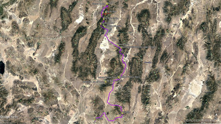
From Stokes Castle, we made our only planned deviation from the BDR route. Having found a write up by dave6253 on AdvRider.com who took a long, sharp, rolling ridge into Austin from the south, I knew this was the route we'd have to take on our way out. It should - in my opinion - be made the BDR route in future iterations.
We started by climbing up a short connector that I'd routed in Google Earth. Extremely steep and more likely an ATV trail than one meant for trucks, I made a mental note to check elevation profiles more carefully in the future. But, as we crested the top, the entire range upened up before us!

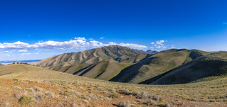
As we anticipated, the road undulated up and down from one peak of the ridgeline to the next, and we happily followed it - albeit in 4Lo for some of the steeper sections.

Our progress already slow as we enjoyed every minute, the final - highest - peak had a little extra something waiting over its crest - an enormous pit mine that had decimated a nearby mountain!

As with other unexpected discoveries along the way - and despite the fact that it was already nearing 7:00pm - we detoured from our detour to go check it out. No longer in operation, it's clearly apparent that some amount of reclaimation of this site has taken place, but it's impossible to fully reclaim a site like this, its impact on the land so great.

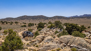
By the time we were done, we knew we needed to find a spot to camp - ideally up here in the mountains somewhere, to help keep the temps a bit more managable than they were getting in the valley's. And, after just a little bit of searching, we settled on a spot that was a little closer to the road than we'd have liked, but that offered spectacular views of the valley below.


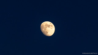
Dinner consisted of the most delicious cheese burgers I think I've ever eaten, and before long we were sitting in our chairs reading as we enjoyed the sunset playing out before us, the moon rising over our shoulders.


It had been another splendid day; we hoped there were many more to come.
Day 3
Camped on the west side of a north-south range, there was no chance for any sort of sunrise, but we were still up early - out of the tent by 6:30am because we knew we had a long day ahead of us; the more miles we could cover before it heated up too much, the happier we'd be.
Then, as we were eating breakfast, I happened to spot something unnatural near the bottom of the mountain. I pointed it out to @mrs.turbodb, who grabbed her binoculars and confirmed that it was in fact some sort of old mining paraphernalia. Of course, that meant we had to go check it out - a detour before we really even got started!


You go, goof.
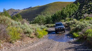
Soon though, we were back on our way, now rejoined to the official BDR track and making good - if a little dusty - time until we arrived at Big Creek Canyon in the Toiyabe National Forest.


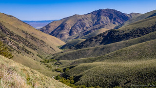
Big Creek Canyon reminded us a bit of our climb up into the Jarbidge Mountains just a couple days earlier - as we wound our way up, we crossed Big Creek several times before climbing up and out of the valley and over what was already our umteenth saddle of the trip.

If you look closely, you can see evidence of mining activity - horizontal banding - on one of the ridgelines below.
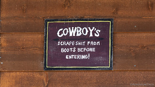
Over the ridge, we made our way down towards the old town of Kingston, but before we arrived, a cluster of white-with-green-trim buildings caught our eye. We knew before we even arrived that this must be an old guard station, specifically the Kingston Guard Station as we pulled up to the fence.
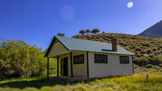

Someone had vandalized the station, breaking the windows and door locks, but it was clear that this had been a nice place to hang out.
Our quick exploration of the four buildings complete, we resumed our bombing run down towards Kingston - another of the old towns that we'd pass along our route. Like many, this town had seen a boom around mining, and then quickly faded as the ore ran lean - its old mill and a few old rock structures all that remained from the original inhabitants.


The old Kingston Mill.
Today, the town struggles to survive - there's not much here except for the old Lucky Spur Saloon - and today the saloon was closed, the town seemingly empty.

Seems reasonable.
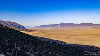
From Kingston, we headed east - crossing another large, flat, hot, valley that led us to the Toquima Range, its rocky outcroppings a new type of geology compared to what we'd seen so far on this trip. While still in the Basin and Range, we were definitely diving deeper into desert landscapes.


Another major difference was that the roads here were like gavel super highways. Plenty of signs along the road informed us that this was likely due to mining that had taken place at the Northumberland mine - another (now legacy) mine that had produced over 230,000 ounces of gold and 485,000 ounces of silver for its owners. And boy, when we came upon the mine, it was quite the operation!

There was still quite a bit of heavy machinery present, and our guess was that the reclamation of this mine was still underway, unlike the one we'd seen just outside of Austin the evening before.
A few photos and a bathroom break later and we were headed toward our next point of interest - the ghost town of Belmont.
Generally referred to as one of the best ghost towns in Nevada - both by books that @mrs.turbodb had brought along on the trip, as well as several web sites I'd discovered as I researched places on and nearby the route prior to leaving, I warned @mrs.turbodb that we'd probably be underwhelmed.
Because when everyone says something is "the best," it usually isn't.
At any rate, enough of my always-such-a-downer attitude -  - the good mining roads meant that we continued at our high rate of speed until we saw another dust cloud approaching. A motorcycle rider, we pulled over to snap a quick photo of the only other (we assume) NVBDR rider we'd see over the entire route!

Who are you, and were you riding the NVBDR on July 2, 2020?
Belmont wasn't far now and as we turned onto the main (paved) street, the first thing that struck us was the lack of "ghost" in this town - save for a few ruins, all of the houses looked reasonably new and were clearly occupied.

Chimney of the Belmont Brickworks, one of the few ruins in this part of town.
Brickworks watchman. Will work for bugs.
Knowing there must be more, we continued on - to Old Belmont, just over the crest of the hill. Here, there were definitely more trappings from the old days, but RV trailers, active residences, and ATV's easily outnumbered and out-tackied what could have been a great place to walk around and enjoy.
We snapped a few photos and were on our way.

Were these really what they claimed to be, or just bait for the tourists?

The old Belmont Courthouse.

Bank - circa 1868.

Burro sculpture - circa 2020.
From Belmont, the NVBDR makes a beeline - south then east, before turning west and then north, at which point it flips south, and then west again to arrive in Tonopah.
We, however, would not take such a direct route. 
Near the town of Belmont, I'd also discovered the ghost town of Manhattan, NV - purportedly with an old bank whose vault remained locked all these years later. And we were going to check it out.
Clearly, I should have realized that anything I researched on the internet about "best ghost towns in Nevada," was likely to result in a similar experience to Belmont - and when we arrived, that was immediately the case. Manhatten did have fewer RV trailers, and was clearly not-quite-as-popular as Belmont, but there were plenty of residences scattered amongst the few remaining ruins.
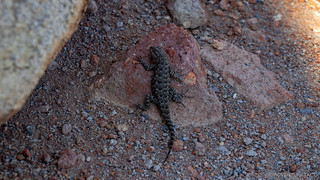
They definitely have a sense of humor here; perhaps the volunteers are lizards.

This small chapel on the hill was moved to Manhattan in 1908 from the nearby town of Belmont where it was built in 1874. Belmont citizens later wanted it back, but were unable to reclaim it.

The infamous bank, its vault visible through a missing front door.

Guess the internet is out of date. Vault is open now.
The real fun of Manhattan though was the road we took out of town. It started as a reasonably graded road - much like the others we'd encountered in the area - but as we got further from town, road maintenance was clearly less of a concern. Even narrower than the road down Telegraph Canyon, this was the only point on the trip where I suggested that it might even be too narrow for a 1st gen Tacoma.
A few pinstripes later and we found ourselves back in a landscape of mixed juniper-and-tundra, and the perfect spot to enjoy another lunch of tuna sandwiches and chips!
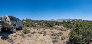
Except for the 95°F heat, what's not to love about this view for lunch?
Our detour to Manhattan complete, we rejoined the NVBDR only a few miles from where we'd left it, all of it's meanderings east, south, west, and north still between us and the end of the stage in Tonopah. It was 2:15pm, and @mrs.turbodb was on her eighth gate of the day.


Up into another north-south range that makes up the basin-and-range landscape of Nevada.
As we approached the next set of mountains, some old ranching equipment caught our eye - could this be the overlanding and insta-expedition trailer we'd always wanted?

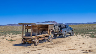

Probably not going to break that diff...given the lack of power train.
A little careful positioning of the Tacoma, and joking around about whether this was our dream trailer and we pushed forward, up into the Monitor Range. Here, two notable sights presented themselves. First, 16 wild horses dotted the landscape - extremely curious who we were, and what type of horse we were riding. Each time we'd stop for a photo, they'd politely turn to face us, and as we'd start rolling again, they'd trot along behind us at a distance.


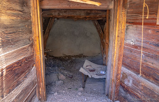
The other discovery was an old dugout as we made our way down and out the south end of the range. We weren't completely clear whether this was a shallow mine or a dwelling, but it'd held up well over the years and would be - at the very least - a great way to get out of the scorching sun during the day!
A few miles later, we found ourselves headed west toward Tonopah on Nevada's Highway 6. It was only for a few miles though - rather than a direct shot into town, the route takes a two-sides-of-the-triangle-are-better-than-one approach and heads northwest and then southwest into town.
At the turn off to dirt however is a rocket. Well, a model rocket anyway - where the highway stripers have clearly got a good sense of humor, or at least an interesting practice area.

Rocket flames, or just a coincidence?
There was nothing notable about the long way into town - the roads were just meh, and the views - even as we passed through the low hills were nothing to write a trip report about.

Perhaps the most interesting aspect of our back way into town was the view we got of Tonopah itself as we crested the last hill. Nestled into a hillside that has clearly been extensively mined (and perhaps is still being mined), we were happy to have achieved the next checkpoint on the NVBDR.

As with the last two, we'd fill up on gas and get out of town - we'd been here many times before and knew it was way to kitschy for our tastes, despite the fact that Lonely Planet: Southwest USA recommended this as a great place to spend the evening!
For us though, it was on to Gold Point - one of our favorite towns of the trip - but not before we hit up Goldfield - home of the International Car Forest; something you definitely don't want to miss...
The Whole Story


Interested in traversing entire states? Check out
More BDR's
for all the amazing routes we've run over the years.
I love your photography and write ups in you trip reports. I’m glad I once followed a link from Expedition Portal... During your research on the internet, did you ever come across Ray Dunakin’s website? http://www.raydunakin.com/Site/Ghost_Towns_and_Mines.html
He’s an amazing model builder and has been exploring the ghost towns of Nevada for 30 years. His photographic record is priceless with an emphasis on buildings and mechanical bits. I know him from him amazing G-scale model Railroad.
Thanks Russell, glad you've found the site, and I hope you've considered subscribing so you get the latest trip reports (I'm a bit behind on ExPo!)
I have run across Ray's site as I've done research, so it's cool to have you mention it as well. I use the site (mostly) to get a sense of what I'll see before I go, since he generally seems to assume that you know where you're going (i.e. no directions, etc.) That of course is fine by me - I know that many of these places only exist because not-so-many people find them!
subscribe here, no junk mail --> https://adventuretaco.com/subscribe/
Tragic that you missed gaining access to the Lucky Spur. It's been integrated as a waypoint for me and my fellow travelers oh-so-many times. It was originally called Zach's Lucky Spur Saloon. Got a write-up in some men's magazine as the best bar in the middle of nowhere. Zach was (probably still is) a larger-than-life character who bought the marquee and adornments from a bankrupt casino in Carson City, then used them to create the place. Apparently lost interest after awhile and sold it to the present owners. Or at least they were still the owners as of September, 2022. I've visited on overland trips and Over Land trips, the latter being landing at the nearby airstrip, pitching a tent at the end of the runway and making the hike to the bar.
Great story about the saloon, and reminds me of the stories of many of these middle-of-nowhere-but-better-than-everywhere-else places that exist across the west. There's something about the folks who do this because they love it, I think - like Zach it sounds like - that really comes through in the way a place presents. They're becoming rarer it seems, but hopefully new "jewels" will show up over time!