Having just gorged ourselves on Wendy's, we weren't in any position to stop at the shop directly below this tantalizing sign as we left town.
While unexpected, we were both glad that things were working out this way. We've found it much more pleasant to end a day halfway through a stage - rather than at the end/beginning of one - in order to find somewhere to setup camp and enjoy a view unobstructed by civilization ...at least to the extent possible.
We appreciated the fact that we weren't going to be camping near town, but boy - there sure was a lot of pavement, so far!
With the final 30 miles of Stage 1 being paved, you can imagine our surprise as Stage 2 began with another 30 miles of pavement to Cascabel, followed by 35 miles of a four-lane, might-as-well-have-been-paved, gravel road to Mammoth, AZ. Those 65 miles flew by in no time, and suddenly - at 4:45pm - we were halfway through Stage 2 and worried that we might find ourselves rolling into the end of the stage at Globe when the sun set a few minutes before 7:00pm!
I suppose that this is technically dirt, but it sure didn't feel like it as we zoomed along at 50+ miles per hour.
This was a new level of non-technicality for us on a BDR, and reminded each of us of our least favorite aspect of the New Mexico BDR - there was just too much of it that didn't feel "backcountry." Still, the smooth trails gave @mrs.turbodb a chance to catch up on her afternoon nap, and I did my best to slow the Tacoma every now and then in order to capture a bit of the environment that was otherwise racing past us along the side of the road.
We hadn't seen any Saguaro Cactus on the first stage, but there were plenty on the second!A couple Saguaro were even fruiting. Or something?!Saguaro Sentinels.A Desert Dandelion (Malacothrix glabrata) (left), and Desert Chicory (right) growing at the base of the Saguaro.
It was at Mammoth - where we crossed to the western bank of the San Pedro River - that the road finally tightened up around us. Nothing technical on the ground, it was the woody vegetation - impinging on the trail - that slowed us down as I worked the steering wheel one way and then the other in order to avoid what could easily ended up being more-than-just-pinstriping along the sides of my green machine.
I suppose it doesn't look too bad here, but anything wider than a 1st gen Tacoma was going to have battle scars after winding through this woody path.
It was also in Mammoth that my copilot related this tidbit she'd discovered prior to our departure:
Founded in 1872, it was in November 2014 that the town of Mammoth was the subject of a fictional horror tale on the Reddit subreddit "/r/nosleep", wherein a contagious disease infected - and then wiped out - the population, while the government tried to contain and deny the entire situation.
Naïve reddit users believed and spread the story, somewhat akin to the 1938 War of the Worlds panic. The town was inundated with phone calls from people trying to ascertain what was happening, and insistence by local authorities that there was nothing going on only added to the theory that a coverup was underway.
After getting a good chuckle out of the story, and doing my best to avoid any branches that could punch a hole in the rubber over of the tent as we sped through the undergrowth, it 6:30pm as we pulled into Winkelman, some 85 miles into the 127-mile-long stage.
The towers of the Winkelman Copper Smelter easily caught our attention as we rolled into town.
We were in no danger of making it to Globe, but boy, we were still way - nearly a full day - ahead of schedule! And so, as the road widened and crossed the San Pedro River, we decided it was time for a bit of high-speed fun in the reasonably shallow water.
First one way......then the other!
After several passes through the lake - the undercarriage and sliders getting a good wash - we headed up Dripping Springs Rd before turning onto Pioneer Basin Rd as the sun dropped down below the horizon.
We ran the final few miles with our own mini suns - Diode Dynamics SS5s - lighting the way.
It was time to find camp and call it a night. Reasonably sure that there wasn't going to be anyone else headed this direction after nightfall, we only briefly looked for spur roads before finding a wide spot along the side of the road where we could setup the tent and wind down with a little reading and photo processing before calling it a night.
We'd covered more than 225 miles in a single day - nearly a full third of the entire route. It felt good - taking some of the pressure to "stay on schedule" off - but also worrisome, that the entire route might be a total bore.
The following morning...
In no rush given how far we'd made it on day 1, sunrise came and went before we lazily donned our clothes and climbed down out of the tent a little after 7:00am. We'd easily wrap up this stage before lunch, and then - we figured - we'd probably wrap up the next one as well!
This nice little spot along a ridge made for a fantastic camp site on our way to Pioneer Pass.After putting away the tent, we traced the ridgeline as we climbed toward Pioneer Pass.
Gaining elevation - and nearly 300 miles into the 750-mile BDR - we hit the first section of trail that wasn't totally smooth. That's not to say there was anything all that technical about it - on the contrary, we'd generally view this type of terrain as "easy going" on any other trip - but this time it was a change to the otherwise pavement-like surfaces we'd endured so far.
Just before 8:00am, @mrs.turbodb spotted a bit of disturbed dirt on the side of the canyon, remarking that it looked like a tailings pile. We weren't expecting a mine at this point along the trail - or at least, I'd not had one marked prior to our departure - but a few seconds later I spotted a chimney climbing above the tree line. Turns out that we'd stumbled what appeared to have originally been an old mining cabin, later converted into a ranch house. Perhaps - given some of the nearby mines - a failed Uranium prospect.
Whatever it was, it was the perfect place to eat breakfast!
The outside of the cabin looked to be in reasonably good shape, so I was excited to check out the interior.Less intriguing than I'd hoped!
As @mrs.turbodb set about assembling bowls, cereal, milk, and the various other bits we'd need for breakfast, I wandered around the site trying to piece together the history. A few roads wandered their way up the sides of the canyon - and there were a few places where it appeared that some minor surface extraction took place - but I couldn't see any major waste piles that indicated possible adits or major diggings. Still, I figured it'd be a good time to break out the drone, so after enjoying a nice cold bowl of Honey Bunches of Oats with Almonds, I fired up the flying camera for a better look around.
This old stone structure behind the main house - guarded by a very loud, I'm-gonna-murder-you squirrel - was one of the more visually interesting things I found as I walked around.The old mill foundation had been converted into a stepped series of small corrals once the property transitioned to ranching activities.Looking down-canyon to the south, Arizona was looking very green in the morning sun!The view up-canyon towards Pioneer Pass was even nicer, but didn't reveal any major workings along the maze of roads that lined both sides of the canyon.
After putzing around for a few minutes to remind myself how poor a pilot I really am with the aerial picture machine, I pressed the button that automatically brings it home and lands it exactly where it lifted into the sky, and we climbed back into our four-wheeled hike-assist vehicle that would take us up and over Pioneer Pass and then down to the end of Stage 2 in the once-metropolis of Globe.
Wrapping our way around Pioneer Pass at what seemed like the top of the world, but was really only 6,114 feet.
The Old Dominion Mining Company was incorporated in Globe in 1880, and ran "on a financial roller-coaster" for the next twenty years.
In 1894, the mine was sold to the Lewisohn Brothers of New York. The arrival of the railroad in 1898 dramatically lowered shipping costs. In 1904, the mine was acquired by Phelps-Dodge, who appointed Louis D. Ricketts as general manager. From 1904 to 1908, Phelps-Dodge spent $2.5 million on expanding and modernizing the mine and plant. As the mine grew, so did Globe.
World War 1 brought increased copper demand; the mine and town both prospered. A strike on the Globe mines was called on July 1, 1917 and federal troops were called in to restore order. By October, miners returned to work, and the mine was back to normal production.
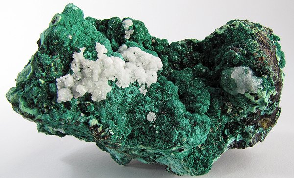
Specimen of malachite from the Old Dominion mine (left); photo by Rob Lavinsky.
Unusual azurite specimen from the Blue Ball mine near Globe (right); photo by Rob Lavinsky.
In the postwar years, the Old Dominion never returned to its former glory. Neglected maintenance, declining ore grades, and flooding underground all took their toll. The mine closed during the recession of 1921 - 1922, and closed permanently in 1931.
In its half-century of operation, the mine produced some 800 million pounds of copper, and returned gross earnings of $134 million to shareholders. It was the economic mainstay for the Globe community for most of this half-century.
The property was sold to the Miami Copper Company as a water supply in 1941, and continues to supply both industrial and domestic water to the area.
We really liked this Arizona-themed welcome sign to Globe.
It was 9:40am when we pulled rolled through Globe and fueled the Tacoma for the coming stage. With two stages complete after just more than a single day of travel, I was starting to worry that we'd complete the entire route in the next couple of days, leaving us with several days to fill before our flight home. Luckily, I'd mapped out a couple of longer hikes, and with the first of those coming up on the next stage, I hoped that our time "on foot" would slow us down enough to extend the trip to the originally-planned six-day adventure.
Mexico to Benson - Unusual Encounters | AZBDR Stage 1-Prologue Running a BDR (Backcountry Discovery Route) this year is going to be a little different for us than it has been in years past, for several reasons. First, we'll be exploring a state that - due to its distance from home, or even Las Vegas where the Tacoma is now stored - we've done very little adventuring through. This should be a great thing, as one of the "problems" with the last couple of BDRs we've explored was that we were already reasonably familiar with what we'd encounter, making the trip less exciting. Second, we'll be running the route…
Benson to Globe - Kinda Boring | AZBDR Stage 2-Having wrapped up Stage 1 of the Arizona Backcountry Discovery Route (BDR) more quickly than we'd anticipated, it was early afternoon as we headed north out of Benson, toward Globe. Having just gorged ourselves on Wendy's, we weren't in any position to stop at the shop directly below this tantalizing sign as we left town. While unexpected, we were both glad that things were working out this way. We've found it much more pleasant to end a day halfway through a stage - rather than at the end/beginning of one - in order to find somewhere to setup camp and…
Globe to Young - Take a Hike | AZBDR Stage 3-Globe definitely won the "best marketing" award of all the towns we passed through on this trip. It was fantastic to photograph. Rolling out of Globe early on our second day of running the Arizona Backcountry Discovery Route (BDR), we were once again on - you guessed it - pavement! This was quickly getting old - as we sped north at speeds we rarely encounter on our adventures - and by now we were pretty sure that the AZBDR wouldn't be climbing to the top of our "favorite BDR" list unless something changed dramatically, and quickly. AZ-288 (the Globe-Young Highway)…
Young to Winona - The Mogollon Rim is Closed | AZBDR Stage 4-As our tires hit pavement in the outskirts of Young, it was time to start thinking about Stage 4. Climbing - and then traversing the Mogollon Rim - this was where satellite imagery, which I'd been watching on a daily basis for several weeks prior to our departure, suggested that 5-19" of snow still blanketed the ground. This didn't look promising. Still, my copilot - having spent the last half hour looking through the road conditions page for the Coconino National Forest - thought we stood a chance, at least in part. Though she confirmed closure of the Forest Service…
Winona to Cameron - Volcanoes, Pueblos, and a Grand Canyon | AZBDR Stage 5-Having "wrapped up" (and by that I mean, essentially, skipped) Stage 4 of the AZBDR in a little under six hours, it was just after 3:30pm when we set out from Winona in search of open roads. The elevations here were nearly as high as those on the Mogollon Rim, so I was a little worried that we'd soon find ourselves blocked by snow, but @mrs.turbodb was reasonably confident that we'd be just fine. As usual, she was right. The snowy San Fransisco Mountains would provide a familiar - and beautiful - backdrop for much of this stage. For the…
Cameron to Utah - The Best for Last | AZBDR Stage 6-A quick recap... We knew even before starting the AZBDR that we'd need a permit to cross the Navajo Nation, and we knew we could conveniently pick up the permit just outside of Cameron, AZ just prior to entering Navajo land. What we didn't know for sure were the hours of the permit office. Knowing that we didn't know, we'd tried calling the permit office earlier in the day - just before visiting Wupatki National Monument - thinking that we could pick up our permit well before the office closed for the day. However, when no one answered the phone,…
Underwhelming | AZBDR Epilogue-The Arizona Backcountry Discovery Route (BDR) is the eighth that we've completed in as many years. Through the experience of each one, @mrs.turbodb and I are - as you can imagine - regularly comparing the current BDR to those we've explored in the past and a few years ago I finally started writing some of these comparisons down. Now, naturally, I feel obligated to carry on that tradition into the future. TL;DR - the Arizona BDR is the least technical that we've run, and the vast majority of the route would rank near the bottom of our list of "best…
Looks less boring than the desk I am sitting at while reading your writeup.
How is the new rear end working out?
We are getting ready to head south to Nevada again to meet up with friends at Middlegate Station then up to Wonder, around the Clan Alpine and finishing in the Dixie Settlement area. But first, the new LRA 33 gallon fuel tank needs to arrive and get installed. As usual, the delivery date is now three weeks past the estimate when I ordered it back in February and I can't get a response from them.
Fingers crossed...
turbodbMay 5, 2024
Hahaha, I suppose that in comparison to a desk, this was a pleasant day on the trail! 😉
Good luck on the fuel tank - 33 gallons sounds like a dream. That's about where I end up with a full tank and three jerry cans!
Once you do get it, have fun out there. Such a beautiful part of the state to explore, and one that I've still got a long list of places to check out.


 Mexico to Benson - Unusual Encounters | AZBDR Stage 1 - Prologue Running a BDR (Backcountry Discovery Route) this year is going to be a little different for us than it has been in years past, for several reasons. First, we'll be exploring a state that - due to its distance from home, or even Las Vegas where the Tacoma is now stored - we've done very little adventuring through. This should be a great thing, as one of the "problems" with the last couple of BDRs we've explored was that we were already reasonably familiar with what we'd encounter, making the trip less exciting. Second, we'll be running the route…
 Benson to Globe - Kinda Boring | AZBDR Stage 2 - Having wrapped up Stage 1 of the Arizona Backcountry Discovery Route (BDR) more quickly than we'd anticipated, it was early afternoon as we headed north out of Benson, toward Globe. Having just gorged ourselves on Wendy's, we weren't in any position to stop at the shop directly below this tantalizing sign as we left town. While unexpected, we were both glad that things were working out this way. We've found it much more pleasant to end a day halfway through a stage - rather than at the end/beginning of one - in order to find somewhere to setup camp and…
 Globe to Young - Take a Hike | AZBDR Stage 3 - Globe definitely won the "best marketing" award of all the towns we passed through on this trip. It was fantastic to photograph. Rolling out of Globe early on our second day of running the Arizona Backcountry Discovery Route (BDR), we were once again on - you guessed it - pavement! This was quickly getting old - as we sped north at speeds we rarely encounter on our adventures - and by now we were pretty sure that the AZBDR wouldn't be climbing to the top of our "favorite BDR" list unless something changed dramatically, and quickly. AZ-288 (the Globe-Young Highway)…
 Young to Winona - The Mogollon Rim is Closed | AZBDR Stage 4 - As our tires hit pavement in the outskirts of Young, it was time to start thinking about Stage 4. Climbing - and then traversing the Mogollon Rim - this was where satellite imagery, which I'd been watching on a daily basis for several weeks prior to our departure, suggested that 5-19" of snow still blanketed the ground. This didn't look promising. Still, my copilot - having spent the last half hour looking through the road conditions page for the Coconino National Forest - thought we stood a chance, at least in part. Though she confirmed closure of the Forest Service…
 Winona to Cameron - Volcanoes, Pueblos, and a Grand Canyon | AZBDR Stage 5 - Having "wrapped up" (and by that I mean, essentially, skipped) Stage 4 of the AZBDR in a little under six hours, it was just after 3:30pm when we set out from Winona in search of open roads. The elevations here were nearly as high as those on the Mogollon Rim, so I was a little worried that we'd soon find ourselves blocked by snow, but @mrs.turbodb was reasonably confident that we'd be just fine. As usual, she was right. The snowy San Fransisco Mountains would provide a familiar - and beautiful - backdrop for much of this stage. For the…
 Cameron to Utah - The Best for Last | AZBDR Stage 6 - A quick recap... We knew even before starting the AZBDR that we'd need a permit to cross the Navajo Nation, and we knew we could conveniently pick up the permit just outside of Cameron, AZ just prior to entering Navajo land. What we didn't know for sure were the hours of the permit office. Knowing that we didn't know, we'd tried calling the permit office earlier in the day - just before visiting Wupatki National Monument - thinking that we could pick up our permit well before the office closed for the day. However, when no one answered the phone,…
 Underwhelming | AZBDR Epilogue - The Arizona Backcountry Discovery Route (BDR) is the eighth that we've completed in as many years. Through the experience of each one, @mrs.turbodb and I are - as you can imagine - regularly comparing the current BDR to those we've explored in the past and a few years ago I finally started writing some of these comparisons down. Now, naturally, I feel obligated to carry on that tradition into the future. TL;DR - the Arizona BDR is the least technical that we've run, and the vast majority of the route would rank near the bottom of our list of "best…


")
")
")


")
")
Looks less boring than the desk I am sitting at while reading your writeup.
How is the new rear end working out?
We are getting ready to head south to Nevada again to meet up with friends at Middlegate Station then up to Wonder, around the Clan Alpine and finishing in the Dixie Settlement area. But first, the new LRA 33 gallon fuel tank needs to arrive and get installed. As usual, the delivery date is now three weeks past the estimate when I ordered it back in February and I can't get a response from them.
Fingers crossed...
Hahaha, I suppose that in comparison to a desk, this was a pleasant day on the trail! 😉
Good luck on the fuel tank - 33 gallons sounds like a dream. That's about where I end up with a full tank and three jerry cans!
Once you do get it, have fun out there. Such a beautiful part of the state to explore, and one that I've still got a long list of places to check out.
Saguaro FRUIT. UJ
Honk honk! Thanks!