
Having modified our itinerary a bit to visit the Black Dragon Pictographs, we popped back onto I-70 and retraced a few miles of freeway through the fins of the San Rafael Reef to one of the more popular areas in the San Rafael Swell - Buckhorn Wash.

Hiking to the top of the fins seems like something that's in our future.
Entering from the south - which seemed to be the less common way, given the 20-miles of gravel road to access the location - we made good time under an increasingly cloudy sky. Naturally, we stopped a few times along the way as views presented themselves, and once when we heard a thunderous clunking sound under the Tacoma. I knew immediately what it was - one of the D-rings on the front bumper had worked itself loose and fallen to the ground, hitting the skid plate along the way. Luckily, @mrs.turbodb spotted the pin after a bit of searching along the roadside, and we were back underway.

At the base of the cliffs runs the San Rafael River, and beyond that, we'd find ourselves winding our way through a maze of canyons.

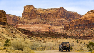
After crossing some 20 miles of flat desert, approaching Buckhorn Wash from the south is rather dramatic.

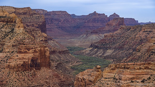
A side view of Bottleneck Peak.
While the main attraction of Buckhorn Wash was rock art - something we were definitely getting our fill of on this trip - our first stop was an old "swinging" bridge that hangs over the San Rafael River. The only suspension bridge remaining in Utah, it was built by the Civilian Conservation Corps between 1935 and 1937 using wood cut from the Manti-LaSal National Forest by Company 959.

The San Rafael River wasn't rushing when we were there, but apparently it was treacherous when the bridge was built, and can be a fun float when the water level is high enough today.
Into the wash.
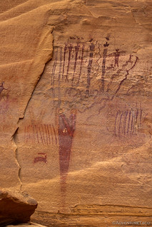
Ten minutes after entering the canyon, we made our first stop - we'd reached the large Buckhorn Wash Pictograph Panel. Likely one of the most well-known panels in the San Rafael Swell, the 130-foot-long panel also contains a few petroglyphs - probably pecked into the sandstone by the Fremont People who lived in the area between 700 and 2000 years ago - but the most interesting renditions are the Barrier Canyon Style pictographs that were made by the Archaic People some 2000 to 4000 years ago.

Whip it! A classic example of Barrier Canyon Style figures with elongated bodies.

Striking Snake.

Jazz-hands, a Snake, and a Flute.

Comb Under a Rainbow.
Common Roots.

Detail of the top of the Common Roots panel.

Rain Angels.

The Center Stage panel.
This site has seen a lot of visitation over the years, as Buckhorn Wash was part of the Old Spanish Trail. Much of the damage done to the panel was done in the 1800s, before Theodore Roosevelt signed the 1906 Antiquities Act, but there's also plenty that's taken place since that time.
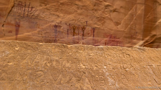
W.R. Stolworthy, Blackfoot, Idaho, 1938.
From the main panel, it was a simple matter of meandering our way north. In and out of the truck on a regular basis, we explored panel after panel - some marked by roadside signage, others indicated by social trails leading away from road-side pull-outs. The key - as is often the case - is to keep an eye out and drive slowly, otherwise you're liable to miss something cool!

I can only imagine what it was like to travel this canyon thousands of years ago. Was there a similar sense of wonder and awe?

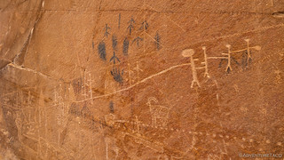
A classic Fremont Style scene at Big Panel, with an emphasis on the animals that the Fremont People focused on in many of their carvings.
Tug-o-War. I also thought it was interesting to see both evergreen and deciduous trees!

Different renditions of sheep and deer, likely by different artists.

I really liked texture of the rocky formation on which these sheep were pecked.
From Big Panel, it was onto the nearby Black Panel, a much smaller work that seems to see less visitation than some of the more popular panels along the route.

Common elements overlooking Buckhorn Wash.
Not far from the Black Panel sits the TKG Panel. Nestled high on the canyon wall, this one has two very cool petroglyphs, but has also been the recipient of quite a lot of vandalism. In fact, the name of the panel - TKG - stems from the moron who used a 50-caliber rifle to pound their initials into the panel from a distance.

Talk about the ultimate in disrespect. (TKG outlines enhanced for easier comprehension.)
The most prominent figure at the TKG panel is the Bird Man who has a human arm on one side and a wing - encompassing a concentric circle - on the other. Closer inspection also reveals a less conspicuous trait - one human foot and one bird foot! I think this might be one of my favorite panels, if it wasn't for all the scratched marks of more recent visitors. 

Bird Man.

Sara and Anton Nielson visited in 1922... and violated the 1906 Antiquities Act.

Figures drawn upside down are thought to represent death, so... Death by Scorpion.
Nearing the northern end of Buckhorn Wash we only had a couple more stops on our agenda, and neither of them were petroglyphs! In fact, one was much older and the other much newer than the rock art we'd been enjoying along the rest of our journey.
First up was the live long and prosper symbol that Vulcan's left on the earth's surface when they first visited long ago. Or maybe a dinosaur track.

Spock was here.

A circle of stones has been placed around the track to protect it from those wandering to find it.
Our last stop was at the Morrison Knudsen (MK) Tunnels (wikipedia) (Cold War Tourist). Named for the United Stated Department of Defense (DoD) contractor that constructed them, there's not all that much to see at the site today - except for an information panel and a short hike to one of the tunnels that is relatively close to the road.

"Top secret" MK Tunnel.
In 1948, when the DoD was looking for naturally occurring defenses from air-delivered explosives, the western flank of the San Rafael Swell became one of the testing grounds. Several horizontal shafts were created, after which varying amounts of explosives - ranging from 320lbs. to 320,000lbs. - were detonated at varying levels above them no fewer than 19 times. The relatively soft rock of the Navajo Sandstone probably didn't perform as well as the hard granite of Colorado where NORAD and other military facilities were ultimately located, and predictably, no military installations were developed here.

It would most definitely be interesting to see where the tunnel leads, given the nature of the experiment.
And with that, our adventure through Buckhorn Wash came to an end. In fact, as it neared 6:00pm, so too were we nearing the end of our time in the San Rafael Swell. Our plan - as it were - was to loop around to The Wedge, where we'd enjoy a birds-eye view of the canyon through which we'd travelled, spend the night, and head north the following morning. That is, if we could find a spot to call home for the evening that wasn't too windy!
I have to say that as we looped south into The Wedge - designated as a special recreation area by copious signage - I started to get a bit nervous. Nearly all of the area is designated as day use only, and there are so many signs that alert visitors to camping in designated sites only that I found myself racing a bit to ensure that we stayed ahead of any vehicles that might be behind us on the road.
But before we could find a camp site, one thing was for certain - we were going to check out the Wedge Overlook of Utah's Little Grand Canyon. This was a spot that a fellow explorer - Randy Langstraat - had suggested to me as something that I really shouldn't miss when we visited the Swell, and given his preferences, I knew it would be spectacular.

I'd say that Little Grand Canyon is quite an apt description.

More zoom.

More more zoom.
More more more zoom.
In the end - as usually happens - everything worked out just fine. Even though there were several other folks who had the same idea we did, there turned out to be plenty of camping, and we were able to get a really nice spot right on the edge of the Wedge where we could air up the tires and fill up the tank for our trip north the next morning.

Our final camp site.

As the sun dipped lower in the sky, the clouds started to clear - just a bit - and it peeked through along the horizon, casting a really nice light over the Swell.

Lenticular clouds suggested that there might be a bit of moisture on its way. We just hoped it held off until we got camp stowed the next morning.
We decided that we'd change up dinner a bit on our final night, and rather than having our usual tacorittos, we broke out some Ramen (with additional fresh veggies) to heat up on the stove. Our thought was that in addition to being a nice change from a taste perspective, it would also be easy.
Let me tell you, it was not. Boiling the water - and keeping it hot - at 6300' turned out to be strangely difficult. In the end, my water was luke-warm and the noodles were overcooked, and we emptied the propane bottle while cooking @mrs.turbodb's, so hers came out crunchy!
You win some, you lose some, and at least our view helped to make up for the tribulations with dinner!

Sunset sunstar.
The Following Morning...
Thankfully, no wind picked up overnight, rendering our spot at the head of the Wedge both calm and cool - the perfect way to snuggle into down comforters for a pleasant night sleep. Plus, the morning brought clear skies - though they wouldn't hang around all day - and more fantastic views out over the Little Grand Canyon. It most definitely was a great way to end our adventure.

Just a few steps away, a several-hundred-foot plunge made for the perfect morning views as color crept across the landscape.

One of our final looks at the buttes of the San Rafael Swell.
Soon, breakfast was made, and the tent was put away for the final time. After a final check of the tires and gas, we headed north - towards Castle Dale - to pavement and fuel that would send us in the direction of home. There, before us, the seemingly omnipresent towers of the PacifiCorp Hunter Coal Powerplant.

Looking north to Huntington, a second powerplant - also run by PacifiCorp - chugged away in the distance.

A landmark from beginning to end of this trip.
It'd been a great trip to the Swell, and it was still hard to believe that this was the first time we'd visited. The best part? We can always come back for more!


I think this is one of your best trips, the photos are spectacular, I see you really need a drone to compliment your photography. I am amazed how many petroglyphs there are, and interesting is some of the new ones.
Keep up the travels!
Kenny
Thanks Kenny, glad to hear you enjoyed this one! I think The San Rafael Swell could become "like Owyhee" for either of us, if only we were closer to it. There's just so much to explore there, and so much history to uncover. Driving, hiking, galore. I'll be back for sure.
And as for the drone - I am, as always, keeping an eye out. Maybe someday I'll actually work up the courage to buy one.
I have to go there. Really nice!
Thank you, Dan!!
You're welcome as always! It's a great place, and I highly recommend the Wedge, even more than Buckhorn Wash. The views from up there are spectacular!
(and sorry for the slow reply, I just found a bunch of comments that were incorrectly marked as spam, so I'll need to dig into the guts of the site to figure out what's going on)
Looks like a Swell road that my truck can handle! That first photo reminds me of the San Andreas Fault a few miles east of here. I'm always sad to see vandalism of history, very sad. And those photos of the Little Grand Canyon are WOW, spectacular. Locally I'm getting closer to being ready for some trips with the Rhino Rack arriving yesterday, several weeks early! Always look forward to your adventures, gives us some new places and ideas to try out in the future, thanks much!
BTW - Always like suspension bridges, the older the better. I crossed many long and big ones during my tour of duty in S.E. Asia in the 1960's, some in the mountains that were spectacular. Oh, and I like your comment about boiling water! During our backpacking trips in the High Sierras it was pretty much impossible to boil water for coffee but it did get darned hot, LOL!
Suspension bridges do seem to hold some sort of magic to them. I've found several people now who've mentioned them to me (or rather, their fascination with them), so much so that I've started to become even more interested in them than I was previously, hahaha! I love it when that happens - it's like discovering something new that's been there all along!
And don't even get me started on hot water. ? The biggest issue, really, is that our propane bottle was on its last legs, and I didn't want to break out a new one for the last night of the trip!
(and sorry for the slow reply, I just found a bunch of comments that were incorrectly marked as spam, so I'll need to dig into the guts of the site to figure out what's going on)
Another great series. I enjoyed this one a lot.
Thanks Tim, glad you enjoyed it!